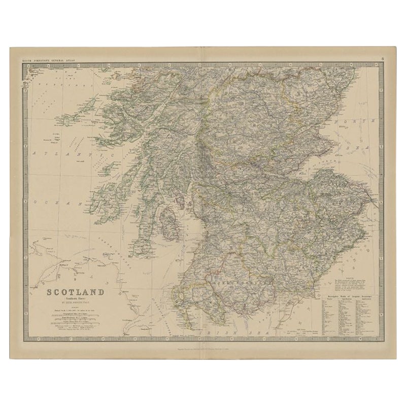
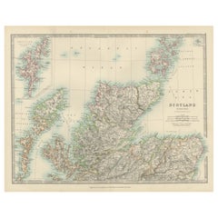
Items Similar to Antique Map of Scotland, 1885 – Highlands, Counties
Coastal Detail
Want more images or videos?
Request additional images or videos from the seller
1 of 11
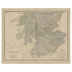
Antique Map of Scotland, 1885 – Highlands, Counties
Coastal Detail
$237.31
£177.16
€200
CA$329.70
A$354.64
CHF 189.53
MX$4,180.15
NOK 2,389.50
SEK 2,184.46
DKK 1,524.22
About the Item
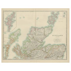
Antique Map of Scotland, 1885 – Highlands, Counties
Coastal Detail
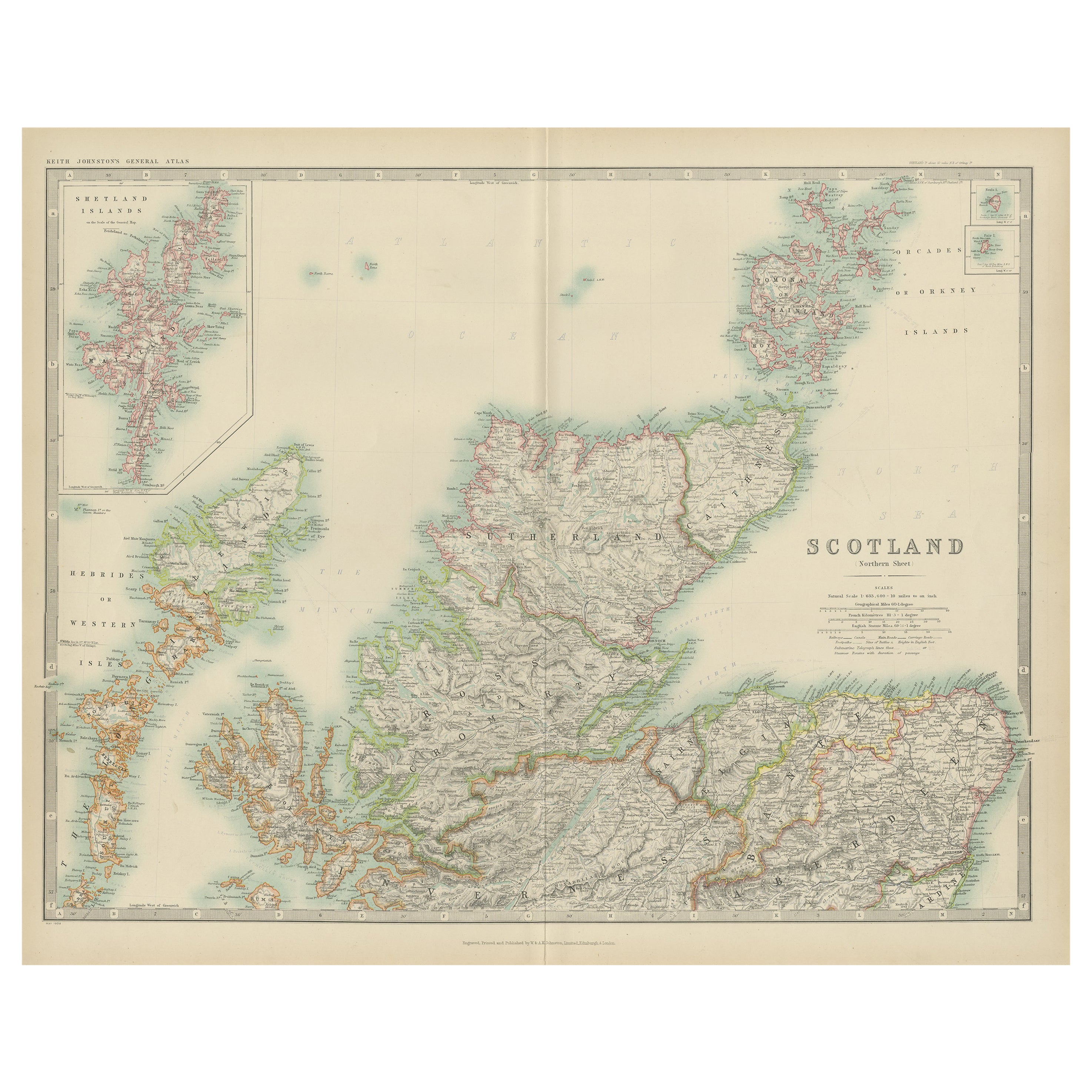
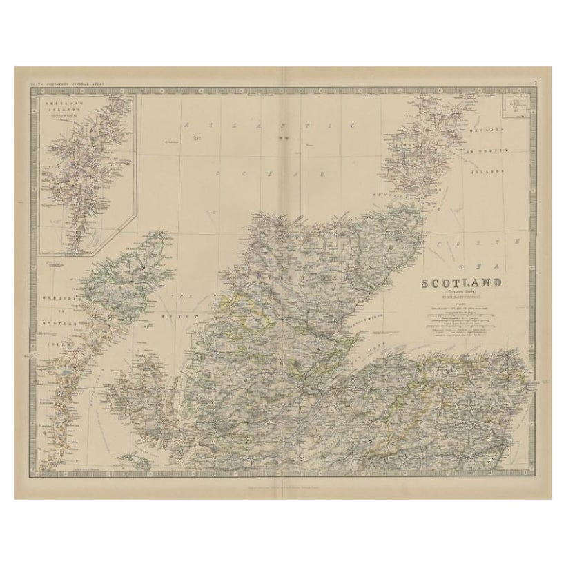
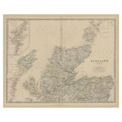
This striking antique map of Scotland was published in 1885 by George W. Bacon in London as part of the *New Large Scale Ordnance Atlas of the British Isles with Plans of Towns*. Compiled from Ordnance Survey data, it shows Scotland divided into its historic counties, each delicately hand-colored and overlaid with a finely engraved network of railways, roads, rivers, and towns.
NOTE: The map is offered unframed, giving flexibility to select a frame that best suits the intended interior.
Visually, the map is especially compelling. The dramatic geography of the Scottish Highlands, islands, and rugged coastline is rendered with great clarity, while the soft pastel county colors create a calm, harmonious surface. Red reference lines and sheet numbers introduce a subtle graphic structure that enhances the composition without overpowering it.
This map works exceptionally well as decorative wall art. Its balance of detail and elegance makes it suitable for studies, libraries, living rooms, offices, or hospitality interiors. It conveys a strong sense of Scottish landscape and heritage while remaining refined and visually approachable, appealing to both designers and decorative buyers.
Condition Report:
Good antique condition. Light age toning and minor spotting consistent with age. No major tears or losses; original coloring remains attractive and well preserved.
Framing Tips:
A dark wood, black, or ebonized frame complements the historic character. An ivory or warm off-white mat will highlight the subtle colors and keep the presentation clean and elegant.
Technique: Lithograph with original color
Maker: George W. Bacon, London, 1885
- Dimensions:Height: 13.31 in (33.8 cm)Width: 9.85 in (25 cm)Depth: 0.01 in (0.2 mm)
- Materials and Techniques:
- Place of Origin:
- Period:
- Date of Manufacture:1885
- Condition:Good antique condition. Light age toning and minor spotting consistent with age. No major tears or losses; original coloring remains attractive and well preserved.
- Seller Location:Langweer, NL
- Reference Number:Seller: BG-14216-2B1stDibs: LU3054348335762
About the Seller
5.0
Recognized Seller
These prestigious sellers are industry leaders and represent the highest echelon for item quality and design.
Platinum Seller
Premium sellers with a 4.7+ rating and 24-hour response times
Established in 2009
1stDibs seller since 2017
2,836 sales on 1stDibs
Typical response time: 1 hour
- ShippingRetrieving quote...Shipping from: Langweer, Netherlands
- Return Policy
More From This Seller
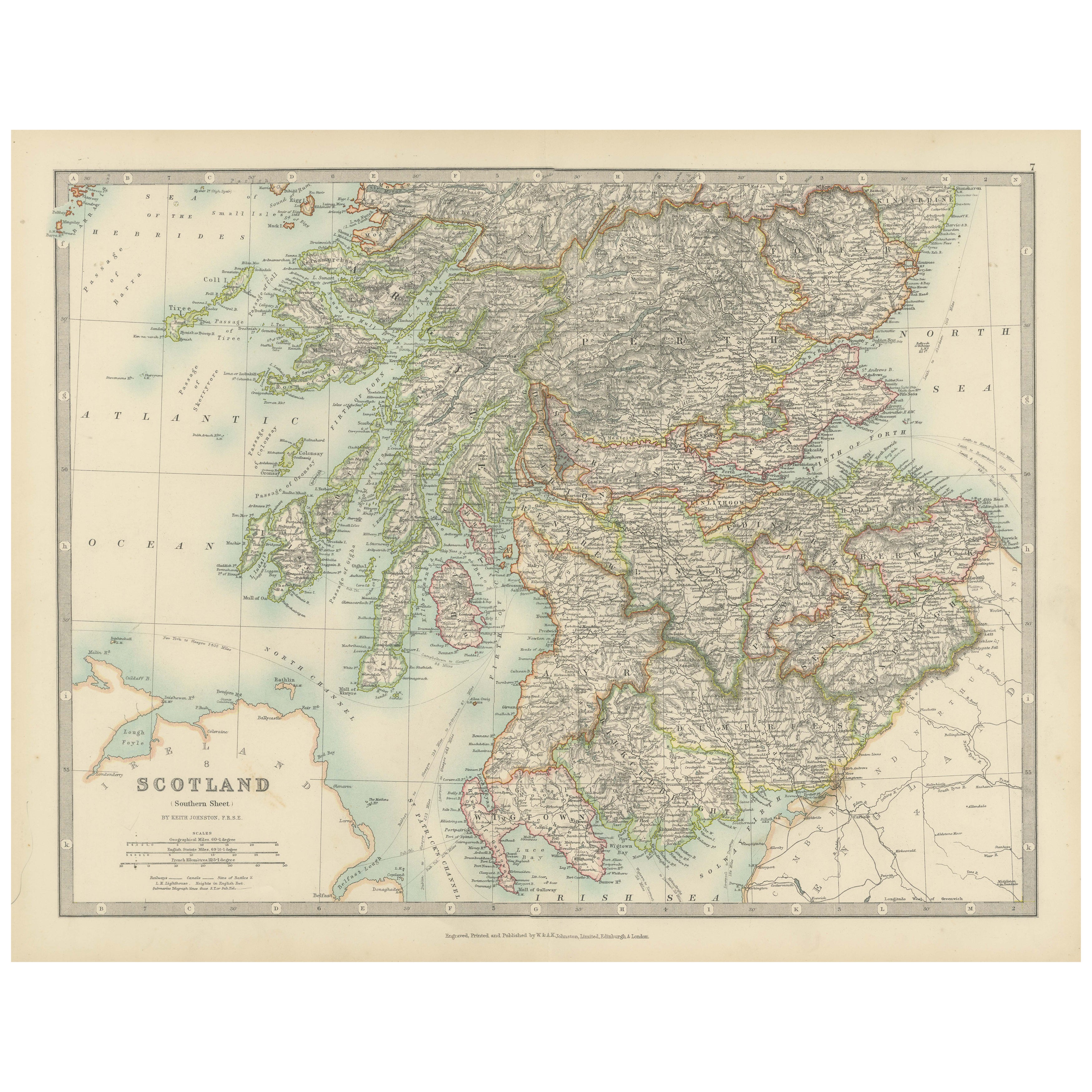
View AllAntique Map of Southern Scotland, 1903, with Coastal and Inland Details
Located in Langweer, NL
Title: Antique Map of Southern Scotland, 1903, with Coastal and Inland Details
Description:
This exquisite antique map, titled "Scotland (Southern Sheet I)," was engraved and publis...
Category
Early 20th Century Maps
Materials
Paper
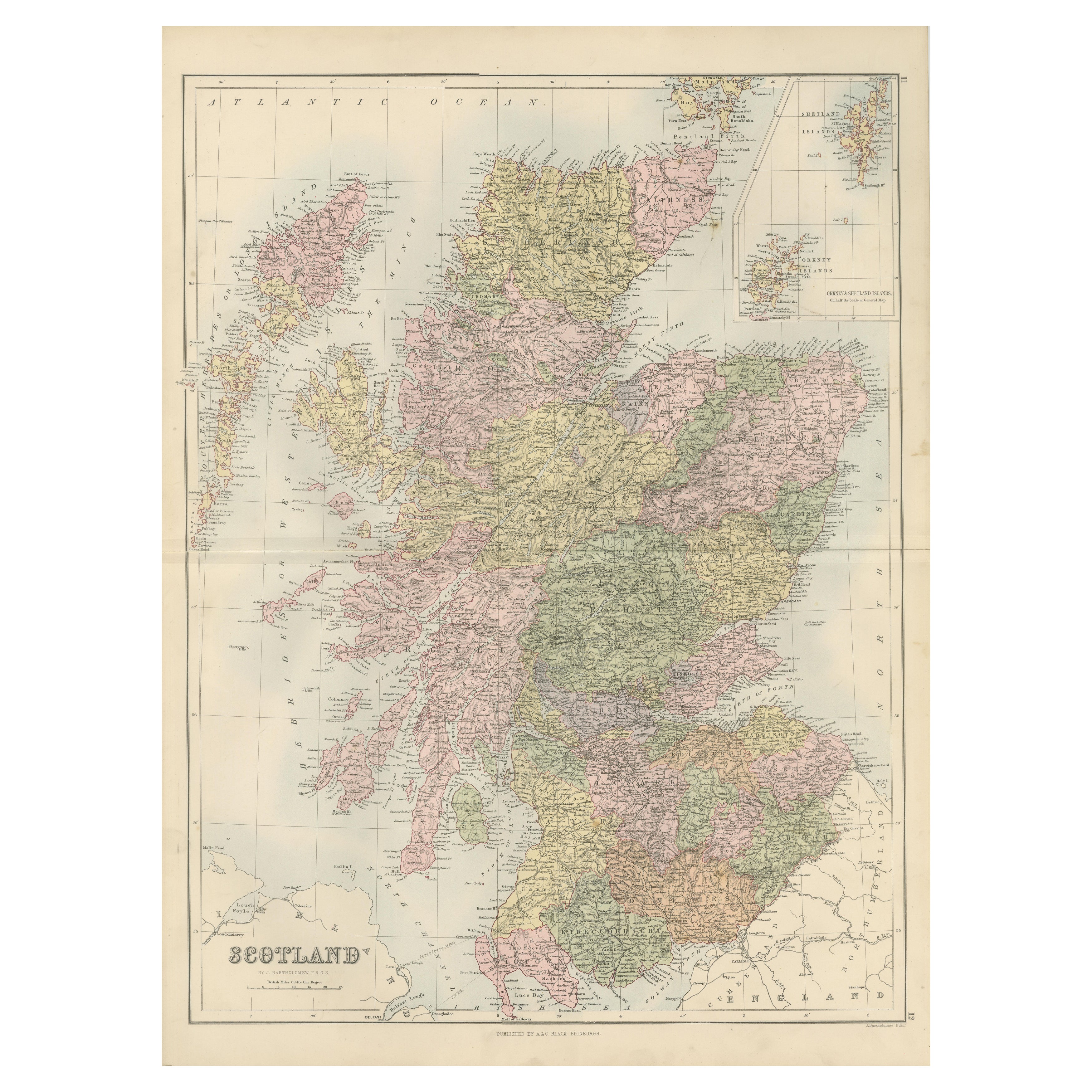
Antique Map of Scotland with Counties and Islands – Black’s Atlas, 1884
Located in Langweer, NL
Here is a catalogue entry in your preferred format for the Scotland map you uploaded:
---
Title: Antique Map of Scotland with Counties and Islands – Bla...
Category
Antique 1880s Scottish Maps
Materials
Paper
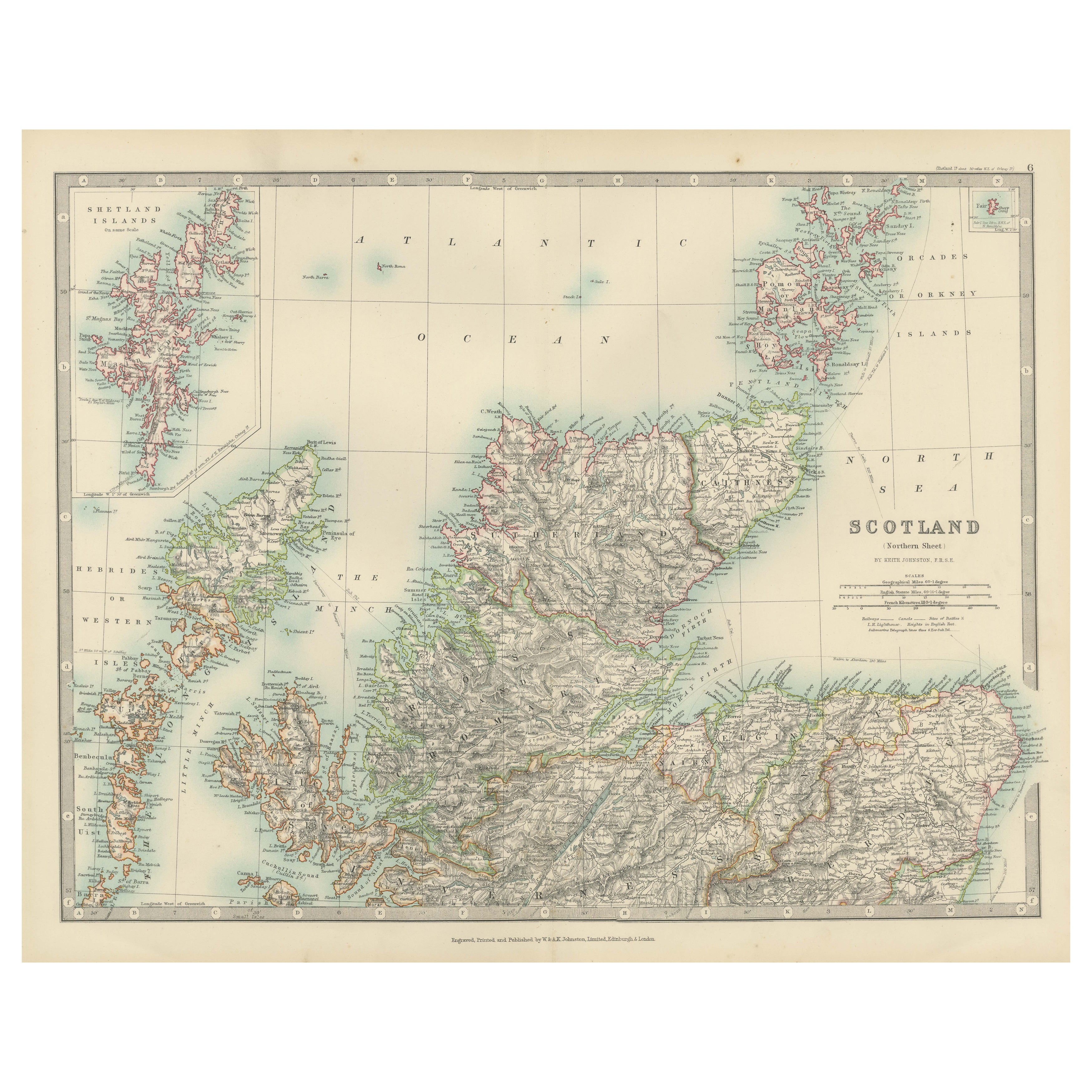
Antique Map of Northern Scotland, 1903, with Intricate Coastal Features
Located in Langweer, NL
Title: Antique Map of Northern Scotland and Islands, 1903, with Intricate Coastal Features
Description:
This striking antique map, titled "Scotland (Northern Sheet I)," was engraved...
Category
Early 20th Century Maps
Materials
Paper
Antique Map of Southern Scotland by Johnston, 1882
Located in Langweer, NL
"Antique map titled 'Scotland'. Old map of Southern Scotland. This map originates from 'The Royal Atlas of Modern Geography, Exhibiting, in a Series of Entirely Original and Authenti...
Category
Antique 19th Century Maps
Materials
Paper
$128 Sale Price
20% Off
Antique Map of Scotland
Northern
by Johnston,
1909
Located in Langweer, NL
Antique map titled 'Scotland'. Original antique map of Scotland. With inset map of the Shetland Islands. This map originates from the ‘Royal Atlas of M...
Category
Early 20th Century Maps
Materials
Paper
$237 Sale Price
20% Off
Antique Map of Northern Scotland by Johnston, 1882
Located in Langweer, NL
Antique map titled 'Scotland'. Old map of Northern Scotland. This map originates from 'The Royal Atlas of Modern Geography, Exhibiting, in a Series of Entirely Original and Authentic...
Category
Antique 19th Century Maps
Materials
Paper
$99 Sale Price
20% Off
You May Also Like
Original Antique Map of Scotland by Dower, circa 1835
Located in St Annes, Lancashire
Nice map of Scotland
Drawn and engraved by J.Dower
Published by Orr & Smith. C.1835
Unframed.
Free shipping
Category
Antique 1830s English Maps
Materials
Paper

England and Wales, Northern Part. Century Atlas antique vintage map
Located in Melbourne, Victoria
'The Century Atlas. England and Wales, Northern Part'
Original antique map, 1903.
Central fold as issued. Map name and number printed on the reverse corners.
Sheet 29.5cm by 40cm.
Category
Early 20th Century Victorian More Prints
Materials
Lithograph

England, Scotland
Ireland: A Hand Colored Map of Great Britain by Tirion
By Isaak Tirion
Located in Alamo, CA
This is a hand-colored double page copperplate map of Great Britain entitled "Nieuwe Kaart van de Eilanden van Groot Brittannien Behelzende de Kon...
Category
Antique Mid-18th Century Dutch Maps
Materials
Paper

Large Original Vintage Map of the United Kingdom, circa 1920
Located in St Annes, Lancashire
Great map of The United Kingdom
Unframed
Original color
By John Bartholomew and Co. Edinburgh Geographical Institute
Published, circa 1920
Free shipping.
Category
Vintage 1920s British Maps
Materials
Paper

Large Original Antique Map of Ireland. C.1900
Located in St Annes, Lancashire
Fabulous map of Ireland
Original color.
Engraved and printed by the George F. Cram Company, Indianapolis.
Published, C.1900.
Unframed.
Free shipping.
Category
Antique 1890s American Maps
Materials
Paper

Antique County Map, Lancashire, English, Framed Lithography, Cartography, C.1860
Located in Hele, Devon, GB
This is an antique lithography map of Lancashire. An English, framed atlas engraving of cartographic interest, dating to the mid 19th century and later.
Superb lithography of Lanca...
Category
Antique Mid-19th Century British Victorian Maps
Materials
Glass, Wood, Paper
