Items Similar to Antique Map of Scotland by Cary,
1811

Want more images or videos?
Request additional images or videos from the seller
1 of 6
Antique Map of Scotland by Cary,
1811
$759.40
$949.2520% Off
£566.93
£708.6620% Off
€640
€80020% Off
CA$1,055.03
CA$1,318.7920% Off
A$1,134.84
A$1,418.5520% Off
CHF 606.49
CHF 758.1120% Off
MX$13,376.49
MX$16,720.6220% Off
NOK 7,646.41
NOK 9,558.0220% Off
SEK 6,990.27
SEK 8,737.8420% Off
DKK 4,877.52
DKK 6,096.9020% Off
About the Item
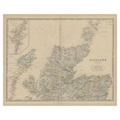
Antique map titled 'A New Map of Scotland from the Latest Authorities':
**Title**: A New Map of Scotland from the Latest Authorities
**Publisher**: J. Cary
**Publication Year**: 1811
This exquisite hand-colored folding map of Scotland, crafted in 1811, offers a detailed and comprehensive portrayal of the country as understood in the early 19th century. Published by the renowned cartographer J. Cary, known for his precision and attention to detail, this map represents the geographical knowledge of Scotland during a significant period in British history.
The map is distinguished by its hand coloring, a characteristic feature of maps from this era that adds both aesthetic appeal and practical value in distinguishing different regions, boundaries, and geographical features. The folding nature of the map indicates its utility for travelers or scholars of the time, providing ease of transport and use.
This map offers a window into the cartographic style and geographical understanding of Scotland in the early 19th century. It would have been an essential tool for both local and international travelers, as well as academics and government officials. The map's creation in 1811 places it in a context of significant historical events and societal changes in Scotland and the United Kingdom, making it a valuable piece for historical study.
- Dimensions:Height: 36.62 in (93 cm)Width: 42.52 in (108 cm)Depth: 0.02 in (0.5 mm)
- Materials and Techniques:
- Period:
- Date of Manufacture:1811
- Condition:General age-related toning. Mounted on linen. Minor wear, please study image carefully.
- Seller Location:Langweer, NL
- Reference Number:Seller: BGJC-3541stDibs: LU3054321190152
About the Seller
5.0
Recognized Seller
These prestigious sellers are industry leaders and represent the highest echelon for item quality and design.
Platinum Seller
Premium sellers with a 4.7+ rating and 24-hour response times
Established in 2009
1stDibs seller since 2017
2,836 sales on 1stDibs
Typical response time: 1 hour
- ShippingRetrieving quote...Shipping from: Langweer, Netherlands
- Return Policy
More From This Seller
View AllAntique Map of the Northern Part of Scotland by Black
1854
Located in Langweer, NL
Antique map titled 'Scotland'. Original map of the northern part of Scotland. With an inset map of the Orkney Isles. This map originates from 'General Atlas Of The World: Containing ...
Category
Antique Mid-19th Century Maps
Materials
Paper

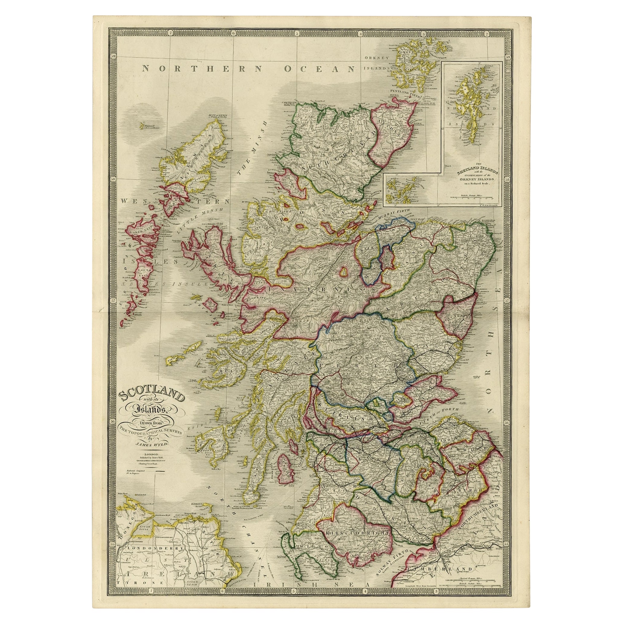
Antique Map of Scotland With an Inset Map of the Shetland Islands, 1854
Located in Langweer, NL
Stunning Map of Scotland that will look beautiful in any setting framed on the wall.
Description: Large Antique map titled 'Scotland with its Islands, drawn from the Topographical surveys...
Category
Antique 1850s Maps
Materials
Paper

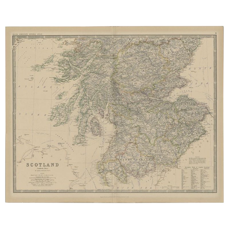
Antique Map of Southern Scotland by Johnston, 1882
Located in Langweer, NL
"Antique map titled 'Scotland'. Old map of Southern Scotland. This map originates from 'The Royal Atlas of Modern Geography, Exhibiting, in a Series of Entirely Original and Authenti...
Category
Antique 19th Century Maps
Materials
Paper
$128 Sale Price
20% Off
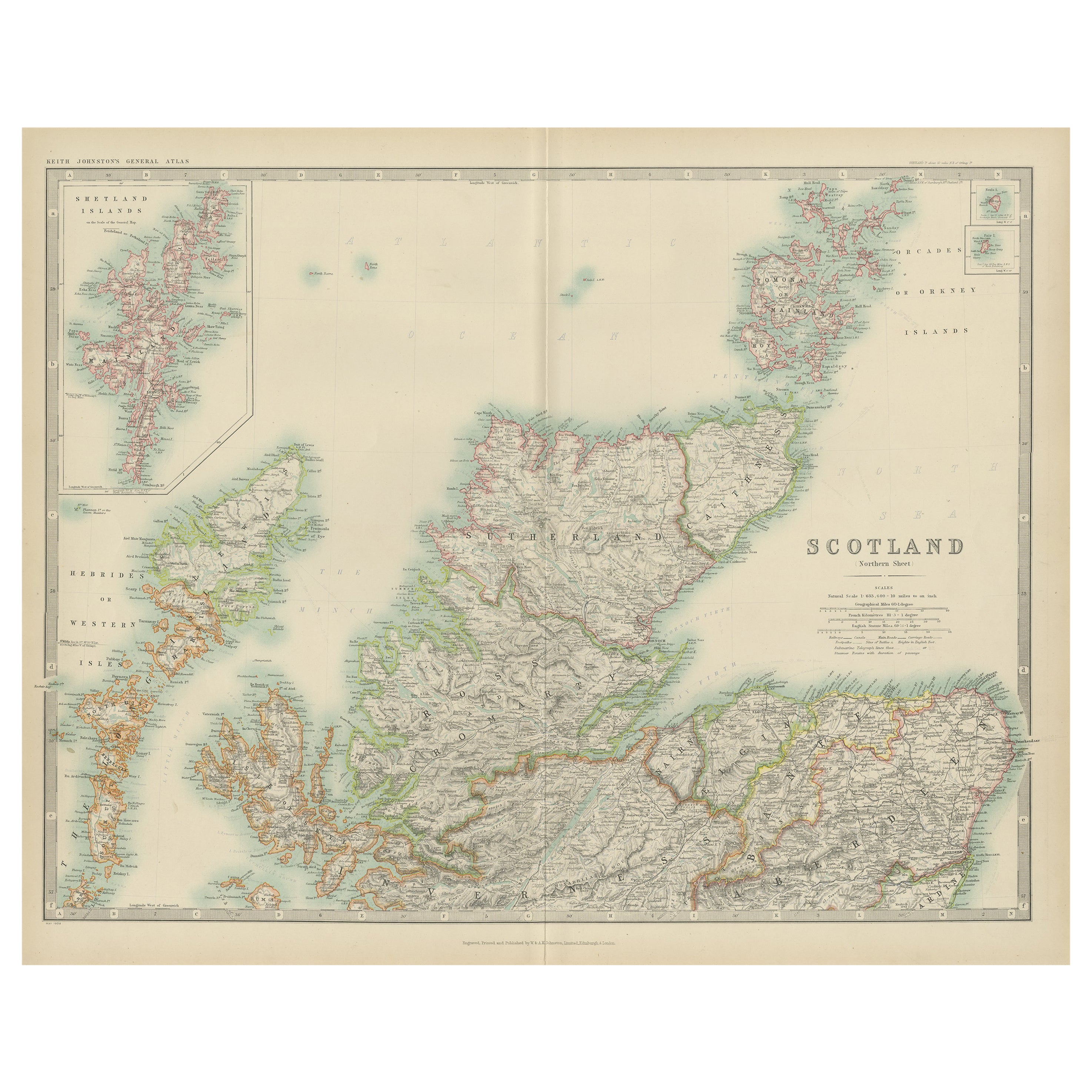
Antique Map of Scotland
Northern
by Johnston,
1909
Located in Langweer, NL
Antique map titled 'Scotland'. Original antique map of Scotland. With inset map of the Shetland Islands. This map originates from the ‘Royal Atlas of M...
Category
Early 20th Century Maps
Materials
Paper
$237 Sale Price
20% Off
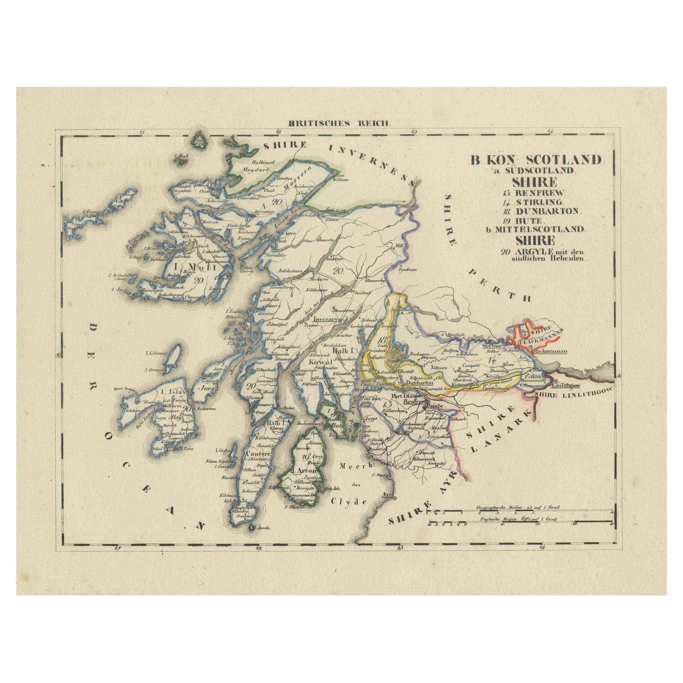
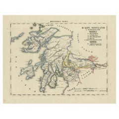
Antique 1830 Map of Scotland with Counties Renfrew, Stirling, Dumbarton and Bute
Located in Langweer, NL
Title: Antique 1830 Map of Scotland with Counties Renfrew, Stirling, Dumbarton, and Bute
Description:
This 1830 German-language map, titled Britisches Reich – B. Kon Scotland, ...
Category
Antique 1830s Maps
Materials
Paper
Antique Map of Northern Scotland by Johnston, 1882
Located in Langweer, NL
Antique map titled 'Scotland'. Old map of Northern Scotland. This map originates from 'The Royal Atlas of Modern Geography, Exhibiting, in a Series of Entirely Original and Authentic...
Category
Antique 19th Century Maps
Materials
Paper
$99 Sale Price
20% Off
You May Also Like
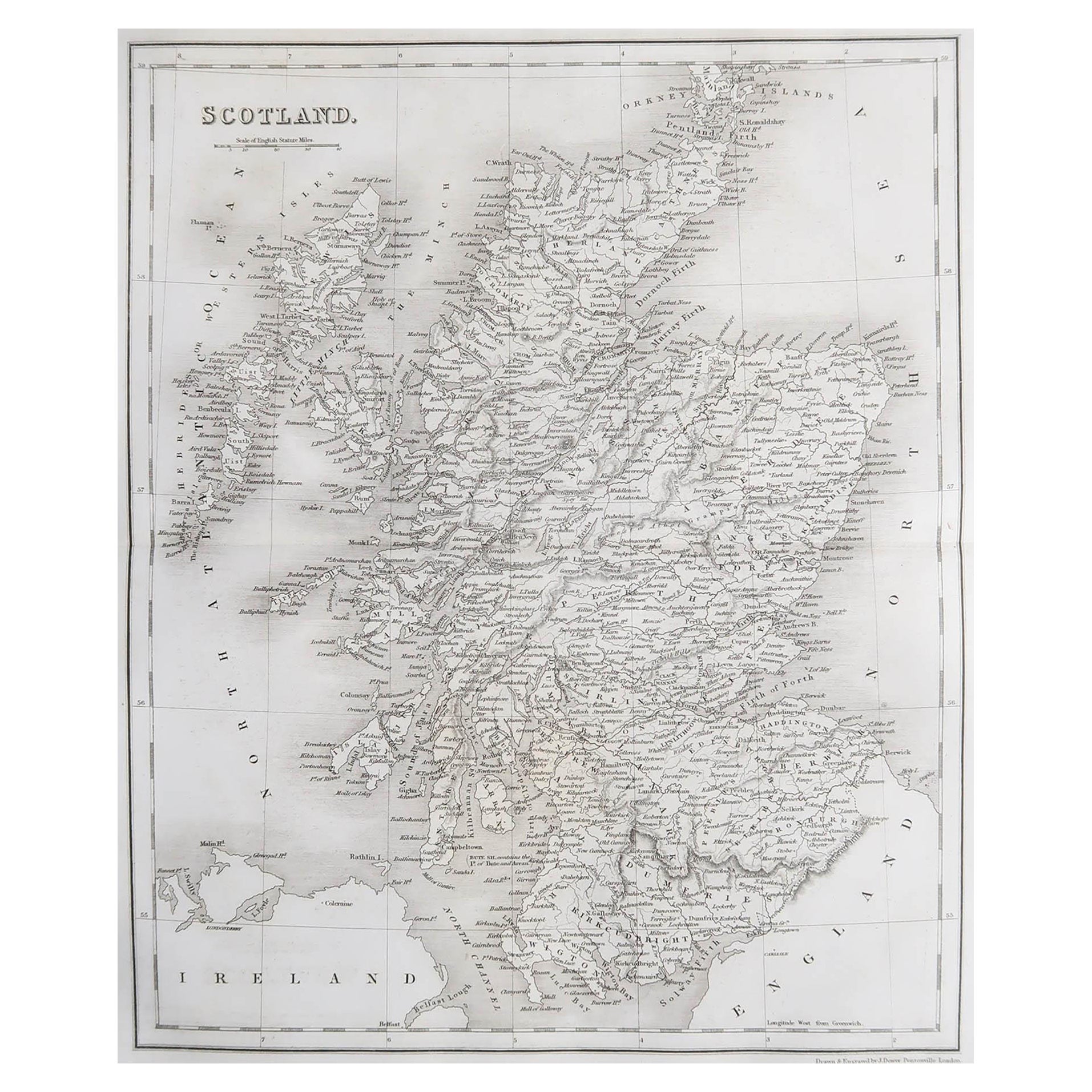
Original Antique Map of Scotland by Dower, circa 1835
Located in St Annes, Lancashire
Nice map of Scotland
Drawn and engraved by J.Dower
Published by Orr & Smith. C.1835
Unframed.
Free shipping
Category
Antique 1830s English Maps
Materials
Paper

Map Southern Scotland Thomas Conder Alex Hogg 1795
Located in BUNGAY, SUFFOLK
A new map of the southern part of Scotland containing the counties of Stirling, Lanerk, Renfrew, Linlithgow, Edinburgh, Peebles, Haddingtoun, Berwick, Selkirk, Roxburgh, Dumfries, Wigtoun, Kirkudbright & Air
Published by Alex Hogg at the Kings Arms...
Category
Antique 18th Century English Georgian Maps
Materials
Paper

Von Reilly Map of the Russian Empire, 1796
Located in Savannah, GA
A map of the Russian Empire in Europe by Von Reilly. Published in Vienna, 1796.
32 inches wide by 24 ½ inches tall
Category
Antique 1790s Austrian Prints
Materials
Glass, Wood, Paper

Large Original Vintage Map of the United Kingdom, circa 1920
Located in St Annes, Lancashire
Great map of The United Kingdom
Unframed
Original color
By John Bartholomew and Co. Edinburgh Geographical Institute
Published, circa 1920
Free shipping.
Category
Vintage 1920s British Maps
Materials
Paper

England, Scotland
Ireland: A Hand Colored Map of Great Britain by Tirion
By Isaak Tirion
Located in Alamo, CA
This is a hand-colored double page copperplate map of Great Britain entitled "Nieuwe Kaart van de Eilanden van Groot Brittannien Behelzende de Kon...
Category
Antique Mid-18th Century Dutch Maps
Materials
Paper

Antique County Map, Lancashire, English, Framed Lithography, Cartography, C.1860
Located in Hele, Devon, GB
This is an antique lithography map of Lancashire. An English, framed atlas engraving of cartographic interest, dating to the mid 19th century and later.
Superb lithography of Lanca...
Category
Antique Mid-19th Century British Victorian Maps
Materials
Glass, Wood, Paper
