Items Similar to Antique Map of Seine Inférieure, France by V. Levasseur, 1854
Want more images or videos?
Request additional images or videos from the seller
1 of 5
Antique Map of Seine Inférieure, France by V. Levasseur, 1854
$237.36
£177.05
€200
CA$330.36
A$354.42
CHF 190.10
MX$4,267.18
NOK 2,396.49
SEK 2,185.26
DKK 1,524.15
About the Item
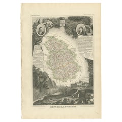
Antique map titled 'Dépt. de la Seine Inférieure'. Map of the French department of Seine Inferieure, France. Centered around its capital of Rouen, this area is known for its production of Gournay, a soft cheese of the fresh Neufchatel type. The map proper is surrounded by elaborate decorative engravings designed to illustrate both the natural beauty and trade richness of the land. There is a short textual history of the regions depicted on both the left and right sides of the map. This map originates from ‘Atlas National de la France Illustré’. Published by A. Combette, Paris: 1854.
- Creator:Victor Levasseur (Artist)
- Dimensions:Height: 13.98 in (35.5 cm)Width: 20.67 in (52.5 cm)Depth: 0.02 in (0.5 mm)
- Materials and Techniques:
- Period:
- Date of Manufacture:1854
- Condition:General age-related toning. Please study image carefully.
- Seller Location:Langweer, NL
- Reference Number:Seller: BG-05614/261stDibs: LU3054310739663
Victor Levasseur
Victor Jules Levasseur (1795–1862) was a French cartographer widely known for his distinctive decorative style. He produced numerous maps more admired for the artistic content of the scenes and data surrounding the map than for the detail of the map. Victor Levasseur was born in 1795 in France. Little is known about his early life and education, but he emerged as one of the most prominent French cartographers of the 19th century. Levasseur lived during a time of significant political and geographical changes in France and Europe, which greatly influenced his work as a mapmaker.
About the Seller
5.0
Recognized Seller
These prestigious sellers are industry leaders and represent the highest echelon for item quality and design.
Platinum Seller
Premium sellers with a 4.7+ rating and 24-hour response times
Established in 2009
1stDibs seller since 2017
2,830 sales on 1stDibs
Typical response time: 1 hour
- ShippingRetrieving quote...Shipping from: Langweer, Netherlands
- Return Policy
More From This Seller
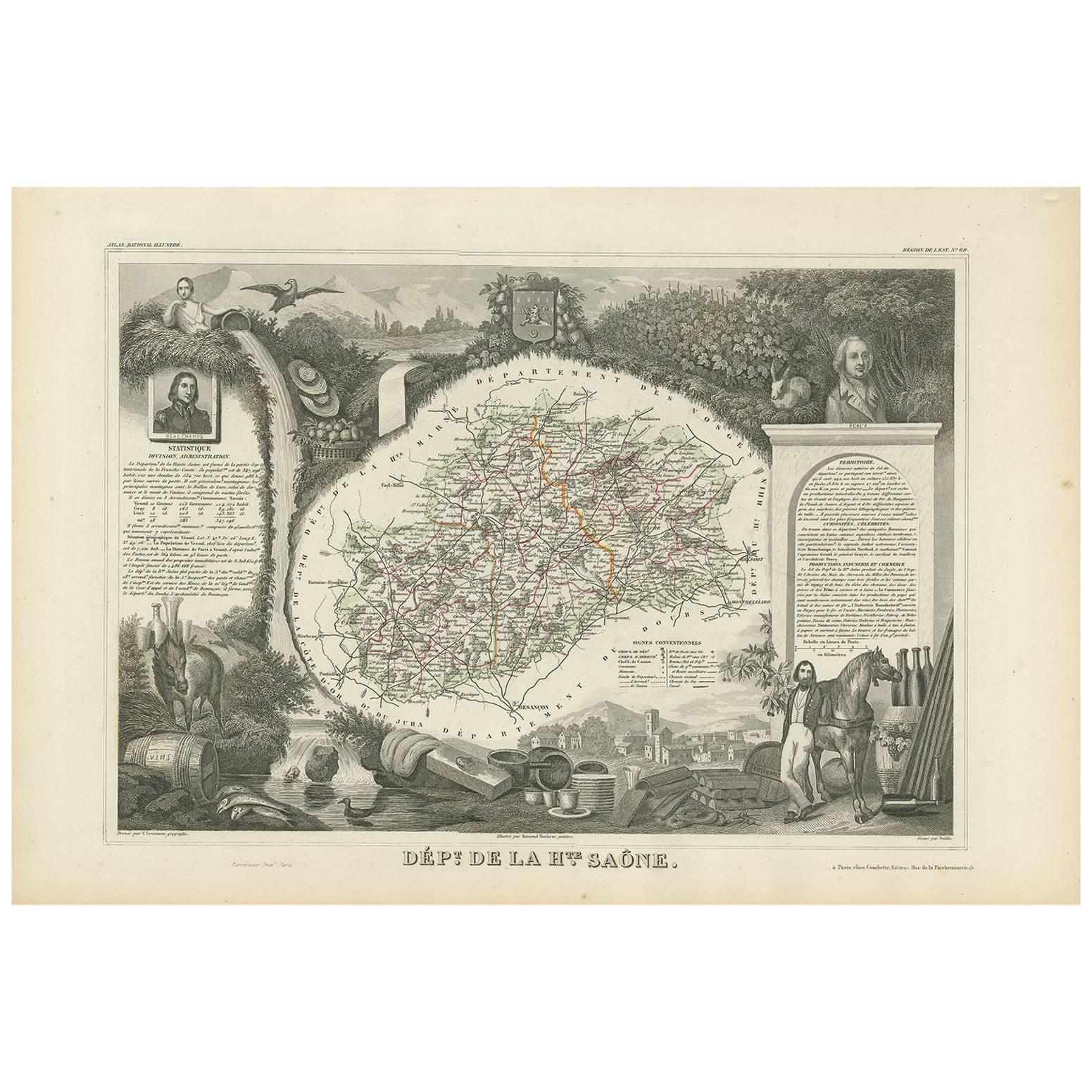
View AllAntique Map of Haute-Saone, France by V. Levasseur, 1854
By Victor Levasseur
Located in Langweer, NL
Antique map titled 'Dépt. de la Hte. Saône'. Map of the French department of Haute-Saone, France. Part of France's important Burgundy or Bourgogne Wine Region. This area is home to t...
Category
Antique Mid-19th Century Maps
Materials
Paper
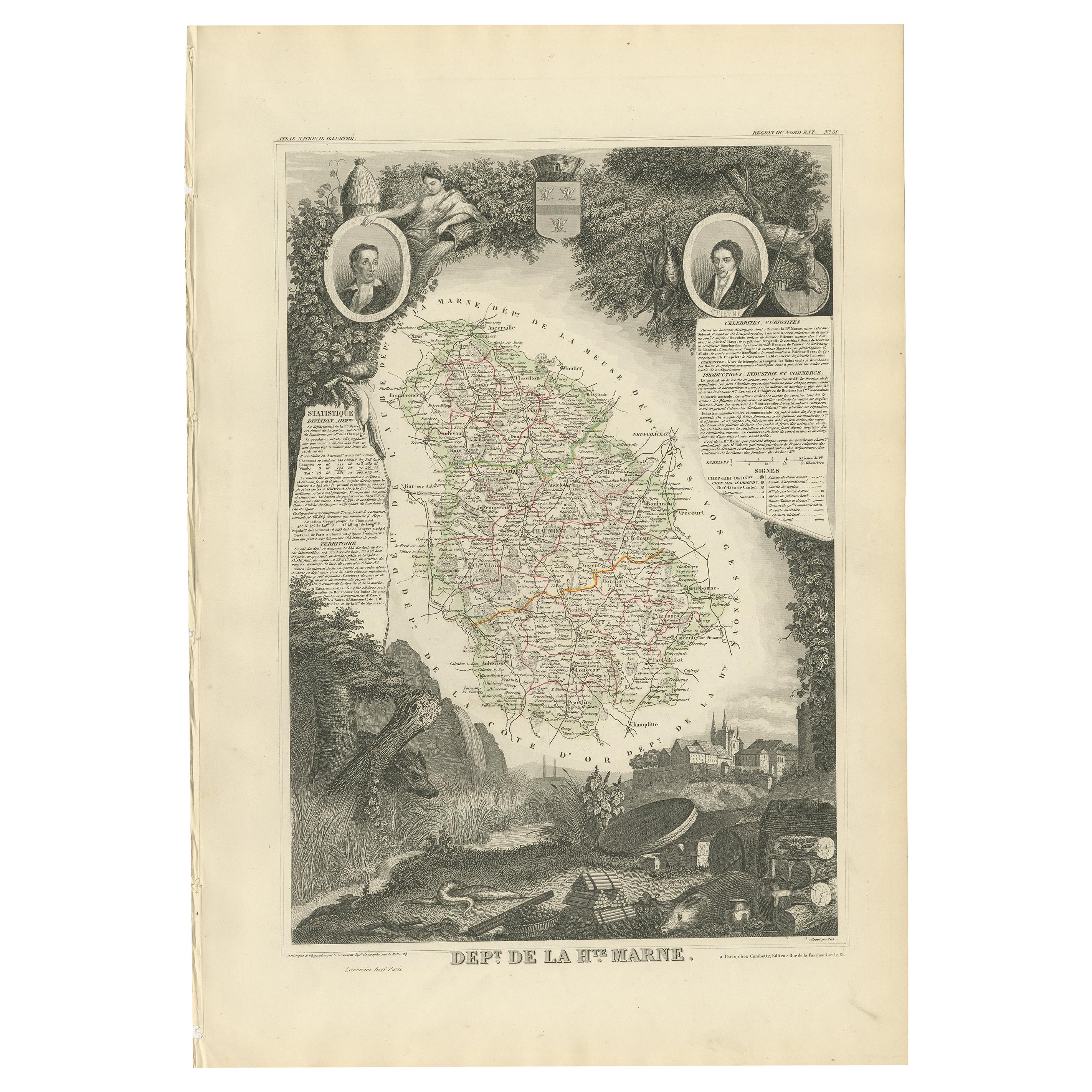
Antique Map of Haute Marne ‘France’ by V. Levasseur, 1854
Located in Langweer, NL
Antique map titled 'Dépt. de la Hte. Marne'. Map of the French department of Haute Marne, France. This department is part of the Champagne region, where the world-famous sparkling wi...
Category
Antique Mid-19th Century Maps
Materials
Paper
$170 Sale Price
20% Off
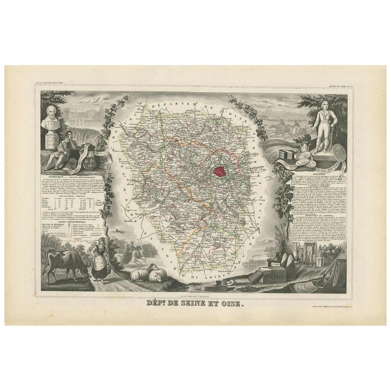
Antique Map of Seine et Oise
France
by V. Levasseur, 1854
By Victor Levasseur
Located in Langweer, NL
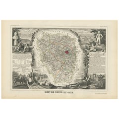
Antique map titled 'Dépt. de Seine et Oise'. Map of the French department of Seine-et-Oise. Centred on Versailles, its administrative centre, Seine-et-Oise extends from Espernon to M...
Category
Antique Mid-19th Century Maps
Materials
Paper
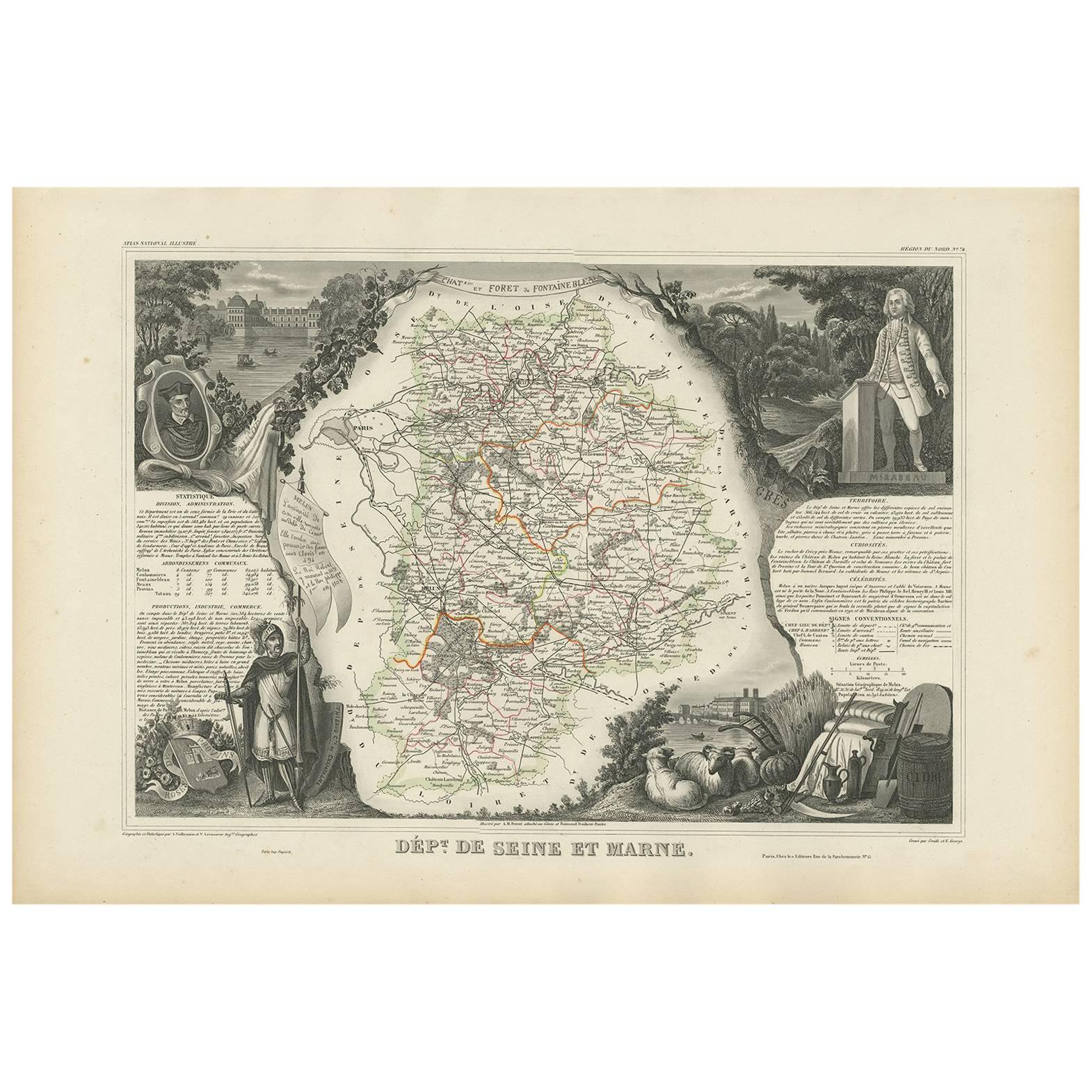
Antique Map of Seine et Marne
France
by V. Levasseur, 1854
By Victor Levasseur
Located in Langweer, NL
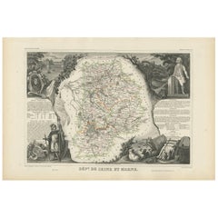
Antique map titled 'Dépt. de Seine et Marne'. Map of the French department of Seine Et Marne, France. This region produces a wide variety of wines and h...
Category
Antique Mid-19th Century Maps
Materials
Paper
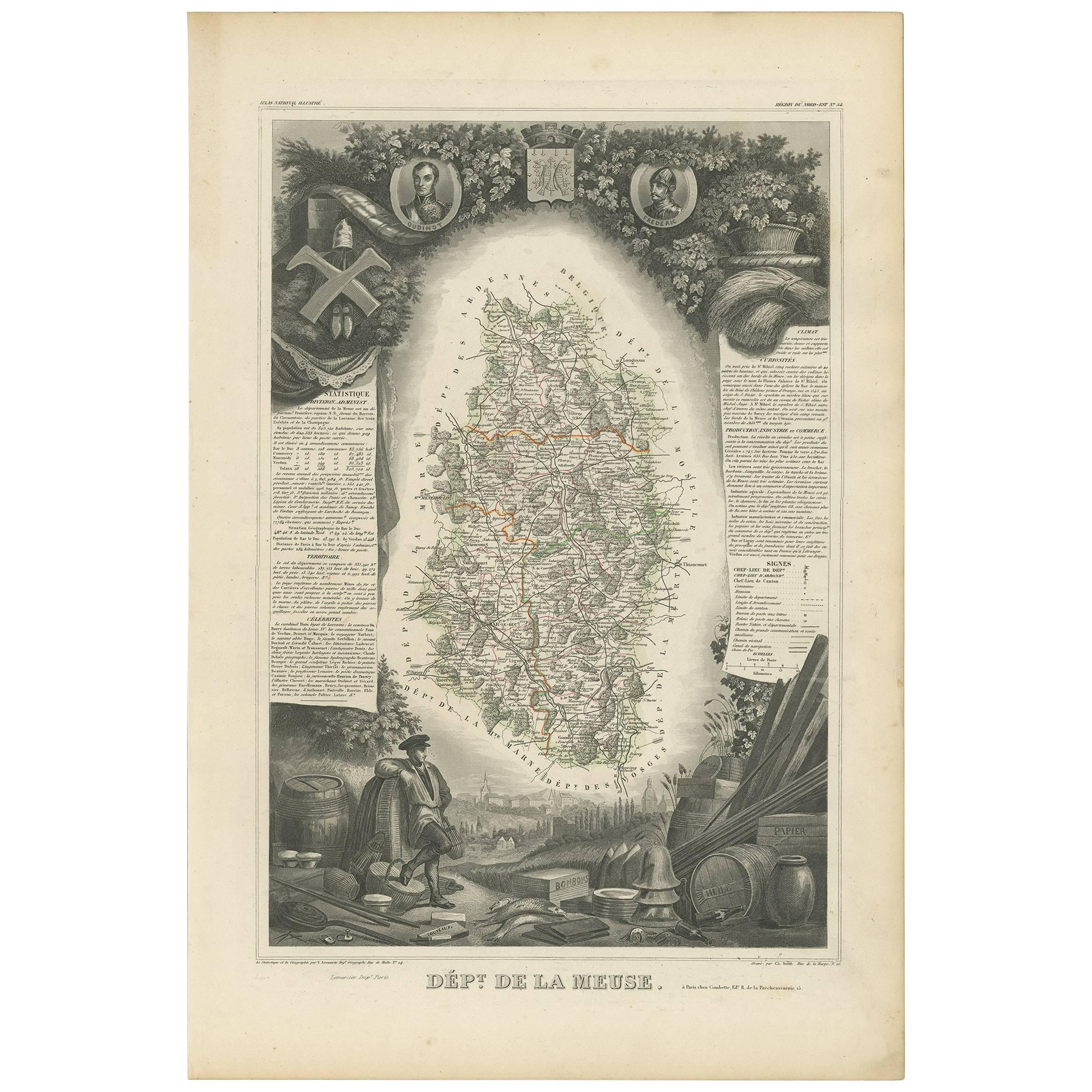
Antique Map of Meuse ‘France’ by V. Levasseur, 1854
Located in Langweer, NL
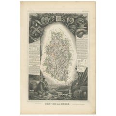
Antique map titled 'Dépt. de la Meuse'. Map of the French department of Meuse, France. This area part of the Lorraine or Alsace-Lorraine wine regions. It is also known for its produc...
Category
Antique Mid-19th Century Maps
Materials
Paper
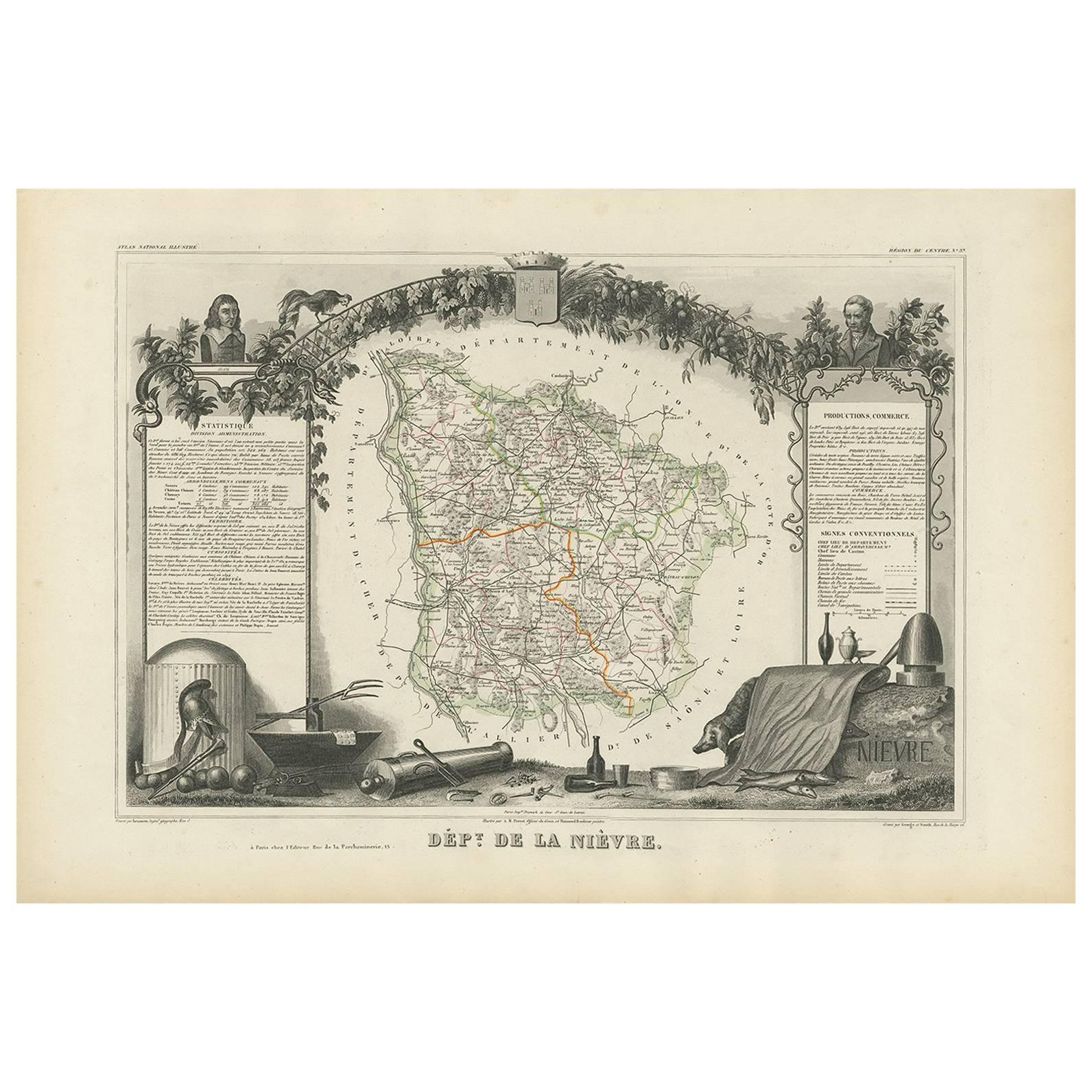
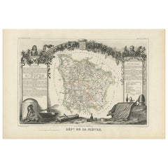
Antique Map of Nièvre ‘France’ by V. Levasseur, 1854
Located in Langweer, NL
Antique map titled 'Dépt. de la Nièvre'. Map of the French department of Nievre, France. Part of the prestiegous Burgundy or Bourgogne wine region this area is known for its producti...
Category
Antique Mid-19th Century Maps
Materials
Paper
You May Also Like
Saone and Loire, France. Antique map of a French department, 1856
By Victor Levasseur
Located in Melbourne, Victoria
'Dept. de Saone et Loire', steel engraving with original outline hand-colouring., 1856, from Levasseur's Atlas National Illustre.
The French department of Saone et Loire is at the ...
Category
19th Century Naturalistic Landscape Prints
Materials
Engraving

L
Isere, France. Antique map of French department, 1856
By Victor Levasseur
Located in Melbourne, Victoria
'Dept. de L'Isere', Steel engraving with original outline hand-colouring., 1856, from Levasseur's 'Atlas National Illustre'.
This area is known for its production of Bleu du Vercor...
Category
19th Century Naturalistic Landscape Prints
Materials
Engraving

Bas Rhin, France. Antique map of a French department, 1856
By Victor Levasseur
Located in Melbourne, Victoria
'Dept. du Bas Rhin', steel engraving with original outline hand-colouring., 1856, from Levasseur's Atlas National Illustre.
Part of the Alsace wine region surrounding Strasbourg. T...
Category
19th Century Naturalistic Landscape Prints
Materials
Engraving

Var, France. Antique map of a French department, 1856
By Victor Levasseur
Located in Melbourne, Victoria
'Dept. du Var', steel engraving with original outline hand-colouring., 1856, from Levasseur's Atlas National Illustre.
Var covers the heart of the French Riviera or Cote d'Azur., and includes the resort cities of Cannes, Nice and San Tropez...
Category
19th Century Naturalistic Landscape Prints
Materials
Engraving

Aude, France. Antique map of a French department, 1856
By Victor Levasseur
Located in Melbourne, Victoria
'Dept. de L' Aude', steel engraving with original outline hand-colouring., 1856, from Levasseur's 'Atlas National Illustre'.
This area of France is famous for its wide variety of v...
Category
19th Century Naturalistic Landscape Prints
Materials
Engraving

Indre and Loire, France. Antique map of a French department, 1856
By Victor Levasseur
Located in Melbourne, Victoria
'Dept. d'Indre et Loire', steel engraving with original outline hand-colouring., 1856, from Levasseur's 'Atlas National Illustre'.
This area is known for its production of Chenin b...
Category
19th Century Naturalistic Landscape Prints
Materials
Engraving

More Ways To Browse
Antique World Maps
Map Of Europe
Antique Maps Of Holland
Compass Rose Antique
Antique Furniture Portugal
Antique Maps Of Europe
Mexican Antiques
Map Of Africa
Mississippi Antique
Antique Furniture Plans
Ancient Collectibles
Antique Wood Coat Of Arms
Antique Quadrant
Antique Maps Of Africa
Antique Map India
Antique Map Of The South Of France
Antique English Maps
Indonesia Map