Items Similar to Antique Map of Southeast Asia by Walker, c.1845


Want more images or videos?
Request additional images or videos from the seller
1 of 5
Antique Map of Southeast Asia by Walker, c.1845
$69.58
$86.9720% Off
£51.69
£64.6120% Off
€58.40
€7320% Off
CA$96.47
CA$120.5920% Off
A$103.75
A$129.6820% Off
CHF 55.47
CHF 69.3420% Off
MX$1,251.17
MX$1,563.9620% Off
NOK 701.51
NOK 876.8820% Off
SEK 639.16
SEK 798.9520% Off
DKK 445.10
DKK 556.3820% Off
About the Item
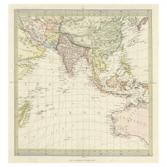
"Untitled map of southeast Asia. This map depicts India, Indonesia, Australia and surrounding regions. Also depicts a large part of the Indian Ocean. Artists and Engravers: Engraved by J.
C. Walker. Published in London.
Artist: Engraved by J.
C. Walker. Published in London.
Condition: Fair, some wear and creasing. Please study image carefully.
Date: c.1845
Overall size: 34 x 42.5 cm.
Image size: 0.001 x 26.5 x 27.5 cm.
Antique prints have long been appreciated for both their aesthetic and investment value. They were the product of engraved, etched or lithographed plates. These plates were handmade out of wood or metal, which required an incredible level of skill, patience and craftsmanship. Whether you have a house with Victorian furniture or more contemporary decor an old engraving can enhance your living space. We offer a wide range of authentic antique prints for any budget.".
- Dimensions:Height: 16.74 in (42.5 cm)Width: 13.39 in (34 cm)Depth: 0 in (0.01 mm)
- Materials and Techniques:
- Period:
- Date of Manufacture:circa 1845
- Condition:
- Seller Location:Langweer, NL
- Reference Number:Seller: BGJC-0031stDibs: LU3054327659752
About the Seller
5.0
Recognized Seller
These prestigious sellers are industry leaders and represent the highest echelon for item quality and design.
Platinum Seller
Premium sellers with a 4.7+ rating and 24-hour response times
Established in 2009
1stDibs seller since 2017
2,826 sales on 1stDibs
Typical response time: 1 hour
- ShippingRetrieving quote...Shipping from: Langweer, Netherlands
- Return Policy
More From This Seller
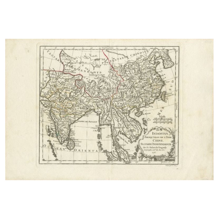
View AllAntique Map of Southeast Asia by Dussy, 1778
Located in Langweer, NL
"Antique map titled 'Indostan presqu'isles de l'Inde, Chine, Tartarie Independante.' - A map of Asia: Hindustan, India and China. This map originates from 'Nouvel Atlas Portatif dest...
Category
Antique 18th Century Maps
Materials
Paper
$209 Sale Price
20% Off
Antique Map of Southern Asia, the East Indies and the Indian Ocean, ca.1840
Located in Langweer, NL
Original antique map of Southern Asia, the East Indies and the Indian Ocean. Also shows part of Australia. Published circa 1840.
Artists and Engravers: ...
Category
Antique 1840s Maps
Materials
Paper
Antique Map of Asia by Lapie, 1842
Located in Langweer, NL
Antique map titled 'Carte de l'Asie'. Map of Asia. This map originates from 'Atlas universel de géographie ancienne et moderne (..)' by Pierre M. Lapie and...
Category
Antique Mid-19th Century French Maps
Materials
Paper

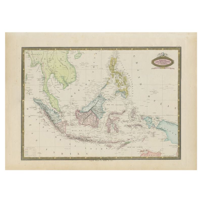
Antique 1860 Map of Southeast Asia by F.A. Garnier
Located in Langweer, NL
"Antique map titled 'Borneo, Iles de la Sonde, Celebes, Moluques et Phillippines'. Antique map of Southeast Asia, from Birma and Sumatra to the Philippines and Nouveau Guinea. Artist...
Category
Antique 19th Century French Maps
Materials
Paper
Antique Map of India and Southeast Asia by Balbi
1847
Located in Langweer, NL
Antique map titled 'India en deçà et au delà du Gange'. Original antique map of India and Souteast Asia. This map originates from 'Abrégé de Géographie (..)' by Adrien Balbi. Publish...
Category
Antique Mid-19th Century Maps
Materials
Paper

$142 Sale Price
20% Off
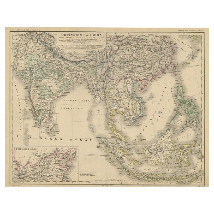
Antique Map of Southeast Asia and China by Kiepert, c.1870
By Thomas Kitchin
Located in Langweer, NL
Antique map titled 'Ostindien und China'. Old map of Southeast Asia and China. This map originates from 'H. Kiepert's Kleiner Atlas der Neueren Geographie für Schule und Haus'. Artis...
Category
Antique 19th Century German Maps
Materials
Paper

You May Also Like
Antique 1803 Italian Map of Asia Including China Indoneseia India
Located in Amsterdam, Noord Holland
Antique 1803 Italian Map of Asia Including China Indoneseia India
Very nice map of Asia. 1803.
Additional information:
Type: Map
Country of Manufacturing: Europe
Period: 19th centu...
Category
Antique 19th Century European Maps
Materials
Paper

$438 Sale Price
39% Off
Original Antique Map of South East Asia by Thomas Clerk, 1817
Located in St Annes, Lancashire
Great map of South East Asia
Copper-plate engraving
Drawn and engraved by Thomas Clerk, Edinburgh.
Published by Mackenzie And Dent, 1817
Unframed.
Category
Antique 1810s English Maps
Materials
Paper

Antique French Map of Asia Including China Indoneseia India, 1783
Located in Amsterdam, Noord Holland
Very nice map of Asia. 1783 Dedie au Roy.
Additional information:
Country of Manufacturing: Europe
Period: 18th century Qing (1661 - 1912)
Condition: Overall Condition B (Good Used)...
Category
Antique 18th Century European Maps
Materials
Paper

$486 Sale Price
40% Off
Large Original Antique Map of Asia by Sidney Hall, 1847
Located in St Annes, Lancashire
Great map of Asia
Drawn and engraved by Sidney Hall
Steel engraving
Original colour outline
Published by A & C Black. 1847
Unframed
Free shipping
Category
Antique 1840s Scottish Maps
Materials
Paper

Original Antique Map of The Eastern Hemisphere by Dower, circa 1835
Located in St Annes, Lancashire
Nice map of the Eastern Hemisphere
Drawn and engraved by J.Dower
Published by Orr & Smith. C.1835
Unframed.
Free shipping
Category
Antique 1830s English Maps
Materials
Paper

Original Antique Map of India by Dower, circa 1835
Located in St Annes, Lancashire
Nice map of India
Drawn and engraved by J.Dower
Published by Orr & Smith. C.1835
Unframed.
Free shipping
Category
Antique 1830s English Maps
Materials
Paper

More Ways To Browse
Antique Walkers
Ptolemy Map
Antique Maps Massachusetts
Antique Maps Singapore
Antique Planisphere
Map Of Palestine
R Johnston
Santa Cruz Island
Shetland Map
Antique Alabama Map
Antique Framed Map Engravings
Antique Furniture Cheshire
Antique Great Lakes Map
Antique Map Of Michigan
Antique Map Of Turkish Empire
Antique Map Of Yorkshire
Bali Map
Bermuda Map