Items Similar to Antique Map of Southern Africa by Levasseur, 1875

Want more images or videos?
Request additional images or videos from the seller
1 of 11
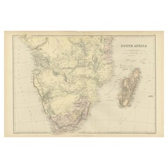
Antique Map of Southern Africa by Levasseur, 1875
$427.16
£318.90
€360
CA$593.45
A$638.35
CHF 341.15
MX$7,524.28
NOK 4,301.11
SEK 3,932.03
DKK 2,743.60
About the Item
Antique map titled 'Afrique Méridionale'. Large map of Southern Africa. This map originates from 'Atlas de Géographie Moderne Physique et Politique' by A. Levasseur. Published 1875.
- Dimensions:Height: 18.71 in (47.5 cm)Width: 24.02 in (61 cm)Depth: 0.02 in (0.5 mm)
- Materials and Techniques:
- Place of Origin:
- Period:
- Date of Manufacture:1875
- Condition:General age-related toning, minor wear. Original folding line, blank verso. Please study images carefully.
- Seller Location:Langweer, NL
- Reference Number:Seller: BG-12257-371stDibs: LU3054320206432
About the Seller
5.0
Recognized Seller
These prestigious sellers are industry leaders and represent the highest echelon for item quality and design.
Platinum Seller
Premium sellers with a 4.7+ rating and 24-hour response times
Established in 2009
1stDibs seller since 2017
2,836 sales on 1stDibs
Typical response time: 1 hour
- ShippingRetrieving quote...Shipping from: Langweer, Netherlands
- Return Policy
More From This Seller
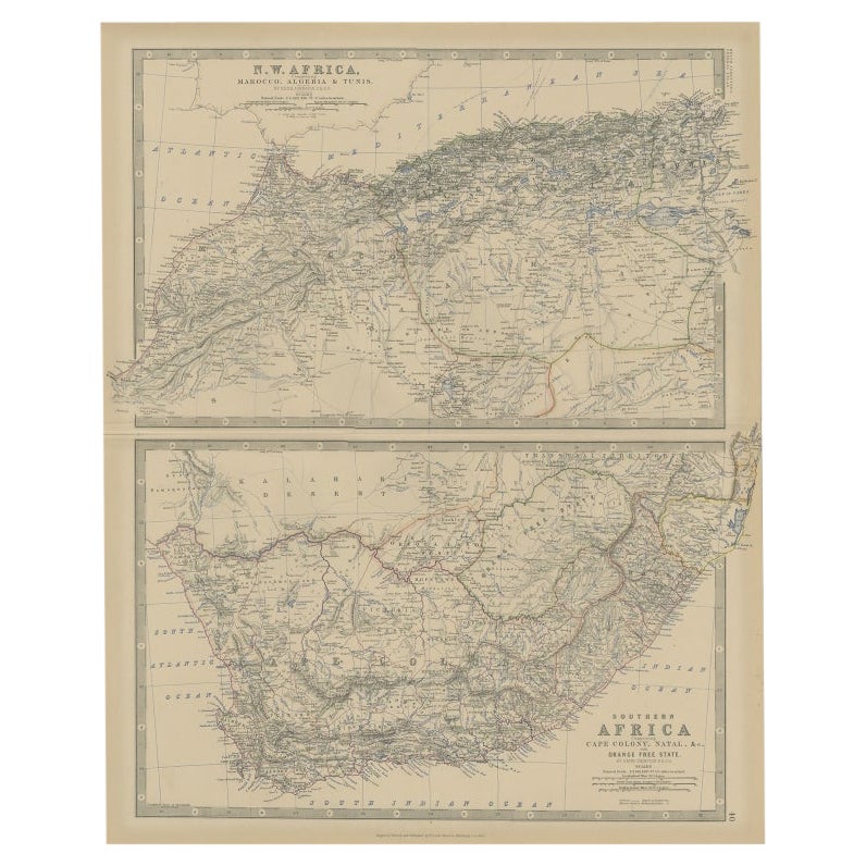
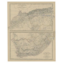
View AllAntique Map of North and South Africa by Johnston, 1882
Located in Langweer, NL
Two antique maps on one sheet titled 'N.W. Africa, Marocco, Algeria & Tunis' and 'Southern Africa, comprising Cape Colony, Natal & c'.
This map originates from 'The Royal Atlas of ...
Category
Antique 19th Century Maps
Materials
Paper
Antique Map of South Africa by Wyld
1845
Located in Langweer, NL
Antique map titled 'South Africa'. Original antique map of South Africa.
This decorative original old map originates from 'An Atlas of th...
Category
Antique Mid-19th Century Maps
Materials
Paper

$189 Sale Price
20% Off
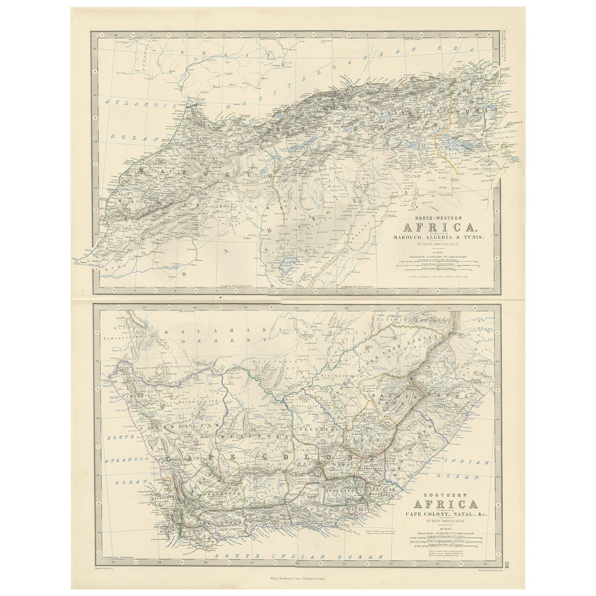
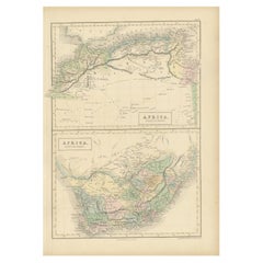
Antique Map of North-Western and South Africa by A.K. Johnston, 1865
Located in Langweer, NL
Two maps on one sheet titled 'North-Western Africa' and 'Southern Africa'. Depicting Morocco, Algeria, Tunis, Cape Colony, Natal and more. This map originates from the ‘Royal Atlas o...
Category
Antique Mid-19th Century British Maps
Materials
Paper

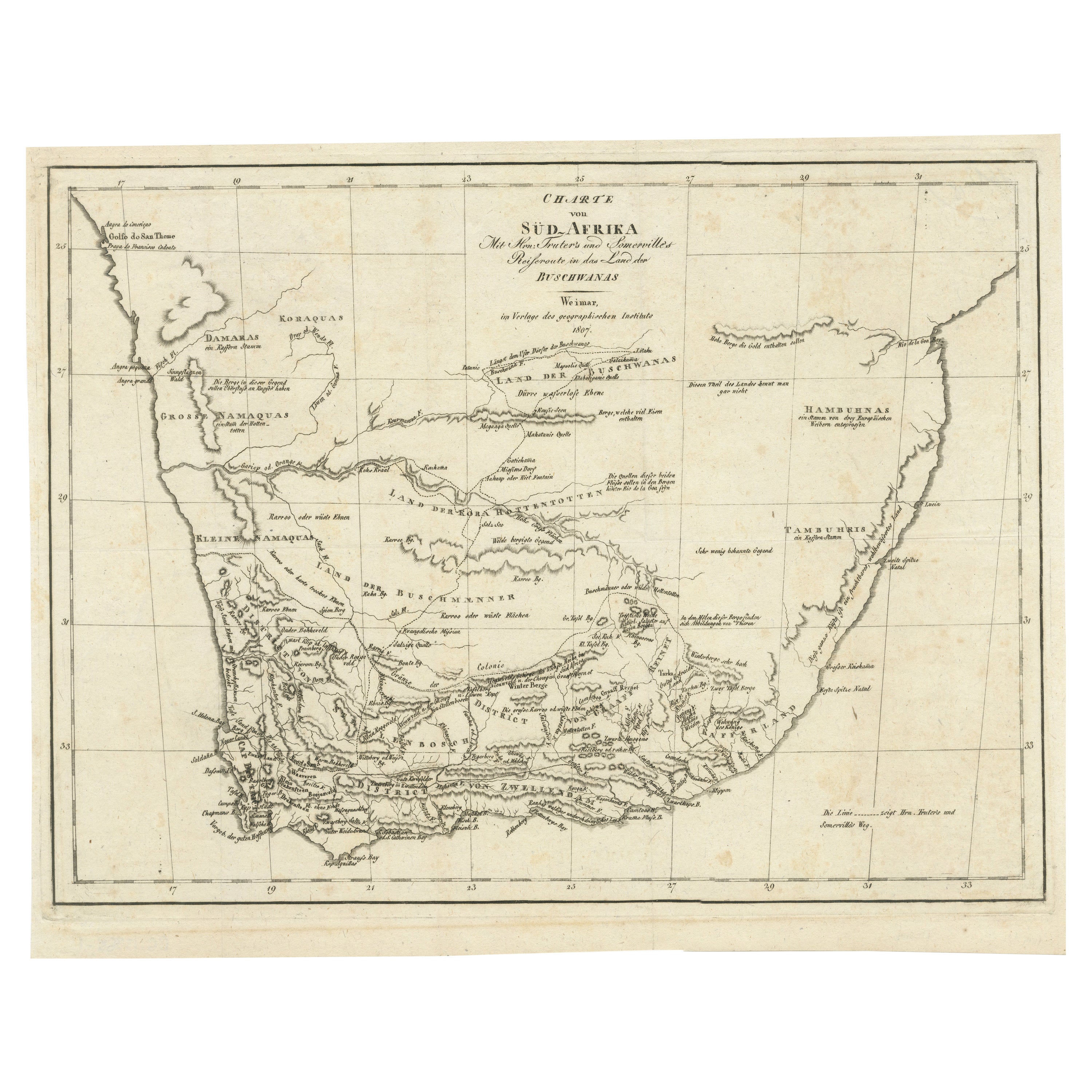
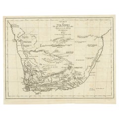
Antique Map of South Africa showing the Travels of Truter and Somerville
Located in Langweer, NL
Antique map titled 'Charte von Süd-Afrika'. Original antique map of South Africa showing the travels of Truter and Somerville. Published ci...
Category
Antique Early 19th Century Maps
Materials
Paper
$398 Sale Price
20% Off
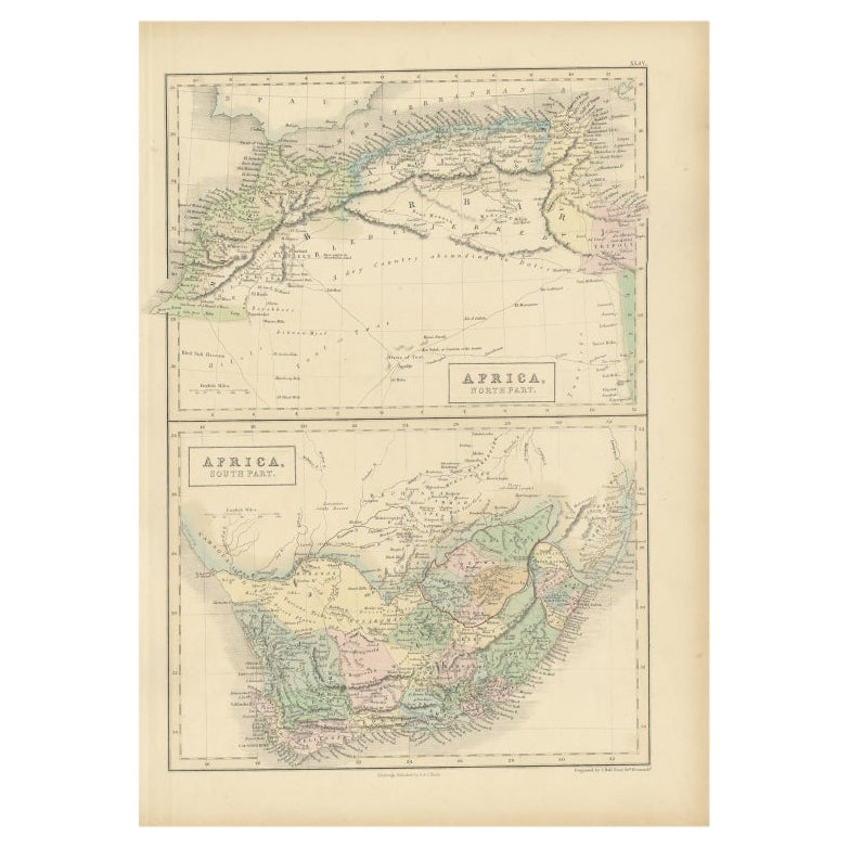
Antique Map of North Africa and South Africa by Black, 1854
Located in Langweer, NL
Antique map titled 'Africa north part - Africa south part'. Old map of Africa showing the region of Morocco, Algeria and South Africa. This map orginates from 'General Atlas Of The W...
Category
Antique 19th Century British Maps
Materials
Paper
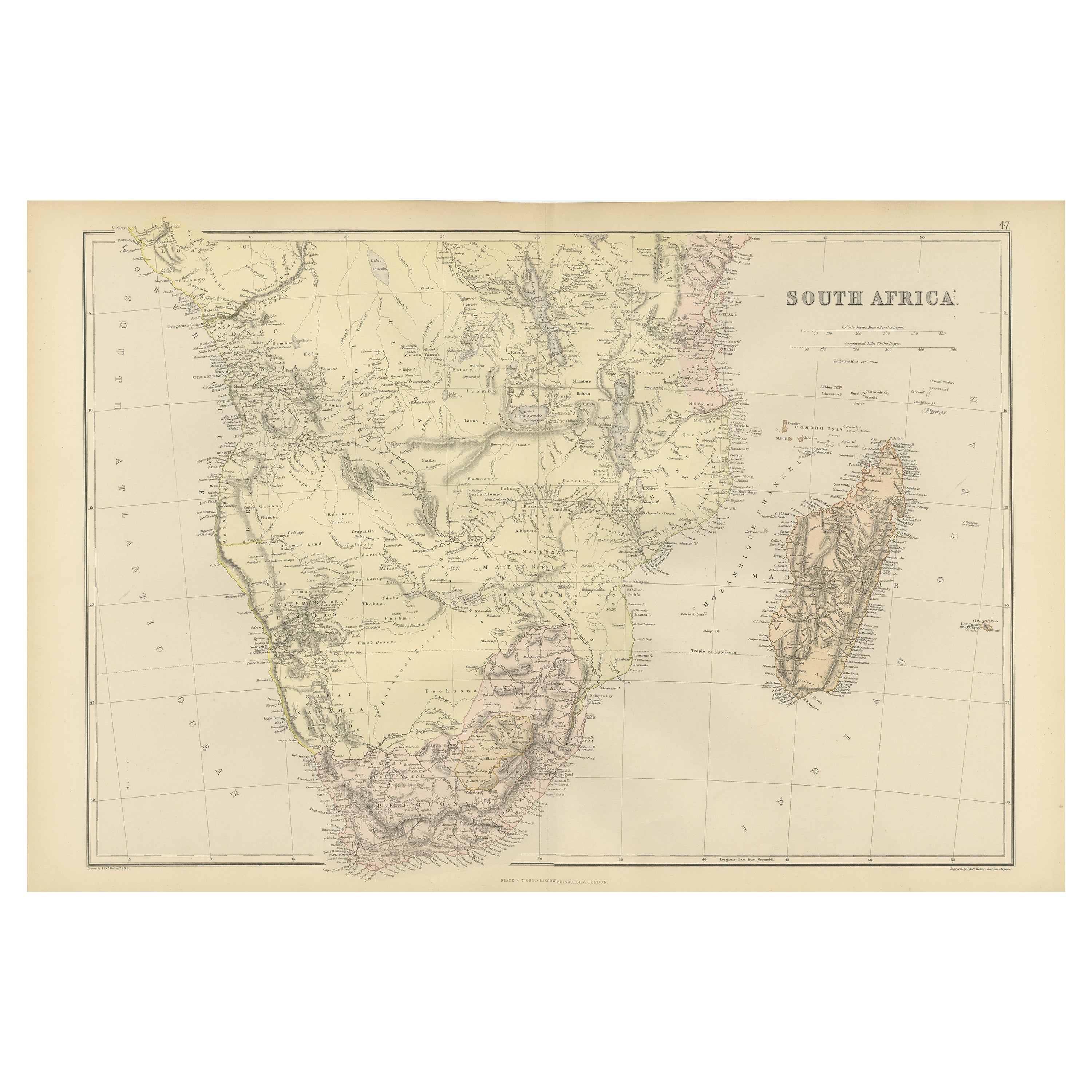
Antique Decorative Coloured Map of South Africa and Madagascar, 1882
Located in Langweer, NL
The map of South Africa is from the Blackie & Son Atlas, published in 1882. This historical map is quite interesting for several reasons:
1. **Historical Period**: This map was crea...
Category
Antique 1880s Maps
Materials
Paper
You May Also Like
Large Original Vintage Map of South Africa, circa 1920
Located in St Annes, Lancashire
Great map of South Africa
Original color.
Good condition / repair to a minor edge tear middle bottom
Published by Alexander Gross
Unframed.
...
Category
Vintage 1920s English Edwardian Maps
Materials
Paper

Africa. Southern Part. Century Atlas antique vintage map
Located in Melbourne, Victoria
'The Century Atlas. Africa. Southern Part'
Original antique map, 1903.
Inset maps of 'Cape Town', 'Johannesburg' and 'Ladysmith'.
Central fold as issued. Map name and number printe...
Category
Early 20th Century Victorian More Prints
Materials
Lithograph

Original Antique Map of South Africa, Arrowsmith, 1820
Located in St Annes, Lancashire
Great map of South Africa.
Drawn under the direction of Arrowsmith.
Copper-plate engraving.
Published by Longman, Hurst, Rees, Orme and Br...
Category
Antique 1820s English Maps
Materials
Paper

Original Antique Map of Africa by Dower, circa 1835
Located in St Annes, Lancashire
Nice map of Africa
Drawn and engraved by J.Dower
Published by Orr & Smith. C.1835
Unframed.
Free shipping
Category
Antique 1830s English Maps
Materials
Paper

Africa. Central. Century Atlas antique vintage map
Located in Melbourne, Victoria
'The Century Atlas. Africa. Central'
Inset map of 'Madagascar'.
Original antique map, 1903.
Central fold as issued. Map name and number printed on the reverse corners.
Sheet 29.5cm...
Category
Early 20th Century Victorian More Prints
Materials
Lithograph

Africa. North-West Part. Century Atlas antique vintage map
Located in Melbourne, Victoria
'The Century Atlas. Africa. Southern Part'
Original antique map, 1903.
Central fold as issued. Map name and number printed on the reverse corners.
Sheet 40cm by 29.5cm.
Category
Early 20th Century Victorian More Prints
Materials
Lithograph

More Ways To Browse
Antique Maps Scotland
Furniture Russian 18th Century
Antique Map Of Middle East
London Antique Maps
Map Colorful
Maps Of Australia
Antique Railroad Furniture
Map Of London
Antique Galleon
Antique Maps Australia
Used Nautical Charts
Antique Collectables Australia
Joan Blaeu
Map Greece
Antique Maps Of New York City
Map Railroad
Antique Railroad Maps
Pirate Antique