Items Similar to Antique Map of Southern Mindanao, Sulawesi and Gilolo Halmahera, Indonesia, 1827

Want more images or videos?
Request additional images or videos from the seller
1 of 10
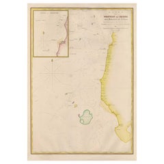
Antique Map of Southern Mindanao, Sulawesi and Gilolo Halmahera, Indonesia, 1827
$677.98
£502.42
€565
CA$926.59
A$1,008.67
CHF 535.40
MX$12,136.52
NOK 6,784.30
SEK 6,216.34
DKK 4,303.77
About the Item
Antique lithograph, with a text vignette on Borneo. This important map for the Philippines shows Southern Mindanao, and the area between Sulawesi, Mindanao and Gilolo (today: Halmahera), part of the Moluccas. Published by P.M.G. Vandermaelen, 1827.
- Dimensions:Height: 20.87 in (53 cm)Width: 26.78 in (68 cm)Depth: 0.02 in (0.5 mm)
- Materials and Techniques:Paper,Engraved
- Place of Origin:
- Period:
- Date of Manufacture:1827
- Condition:Good. Please study image carefully.
- Seller Location:Langweer, NL
- Reference Number:Seller: D-04611stDibs: LU305439811541
About the Seller
5.0
Recognized Seller
These prestigious sellers are industry leaders and represent the highest echelon for item quality and design.
Platinum Seller
Premium sellers with a 4.7+ rating and 24-hour response times
Established in 2009
1stDibs seller since 2017
2,816 sales on 1stDibs
Typical response time: 1 hour
- ShippingRetrieving quote...Shipping from: Langweer, Netherlands
- Return Policy
More From This Seller
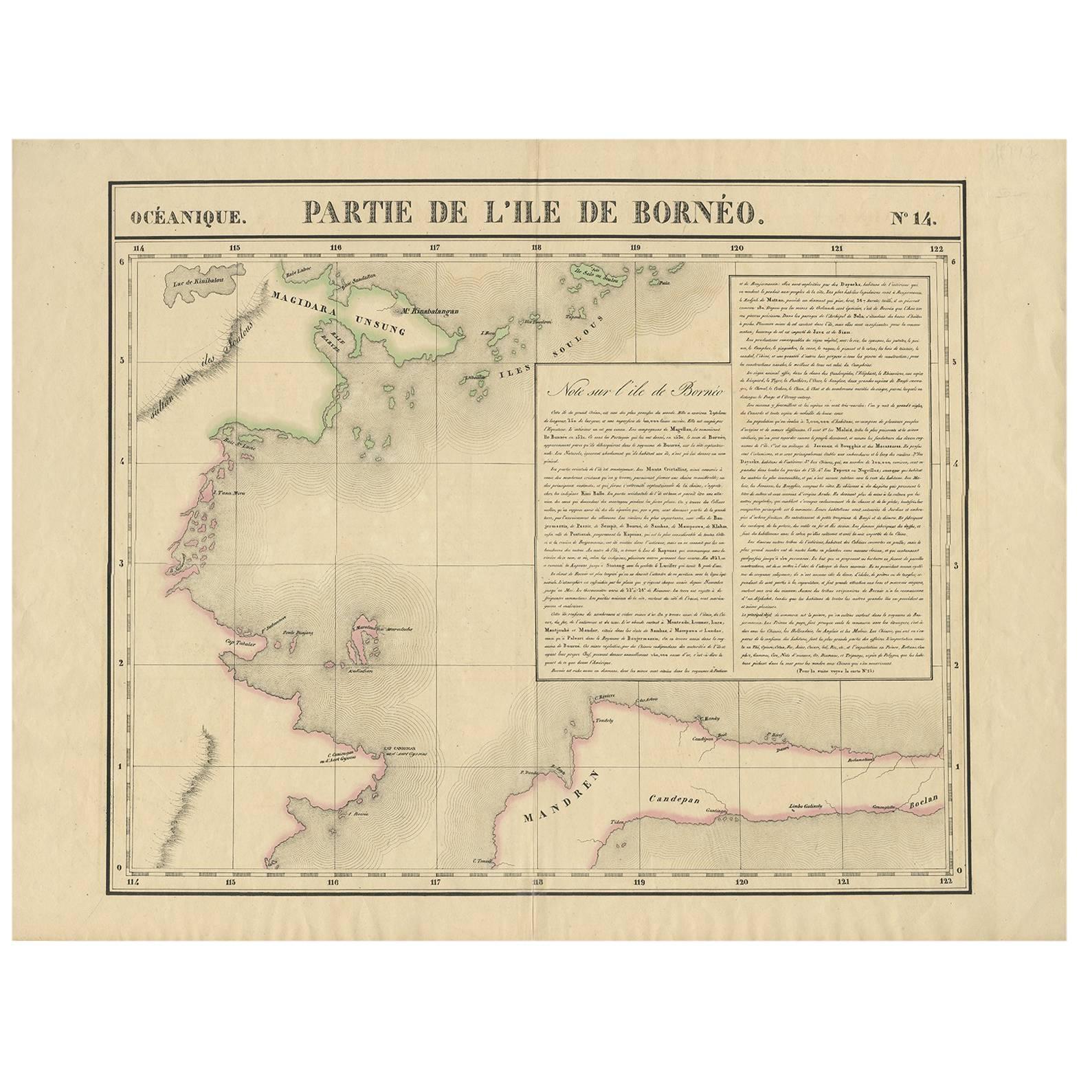
View AllAntique Map of North East Borneo and North Sulawesi by P.M.G. Vandermaelen
Located in Langweer, NL
Contemporary colored lithographed map. Relief shown pictorially and by hachures. Covers North Eastern Borneo and part of Northern Sulawesi.
Category
Antique Early 19th Century Maps
Materials
Paper

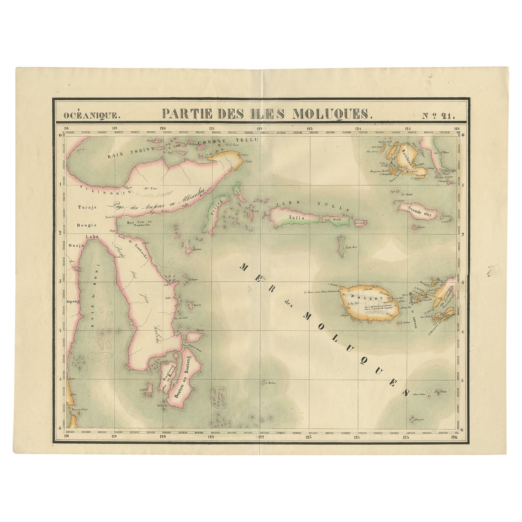
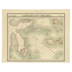
Old Map of the Moluccas and Part of Sulawesi Indonesia by Vandermaelen, c 1825
Located in Langweer, NL
Antique map titled 'Partie des Iles Moluques'. Map of a portion of the Moluccas and part of Sulawesi. Includes the Maluku islands Buru, Sula, Bacan and more. Originates from 'Atlas U...
Category
Antique 19th Century Maps
Materials
Paper
$604 Sale Price
20% Off
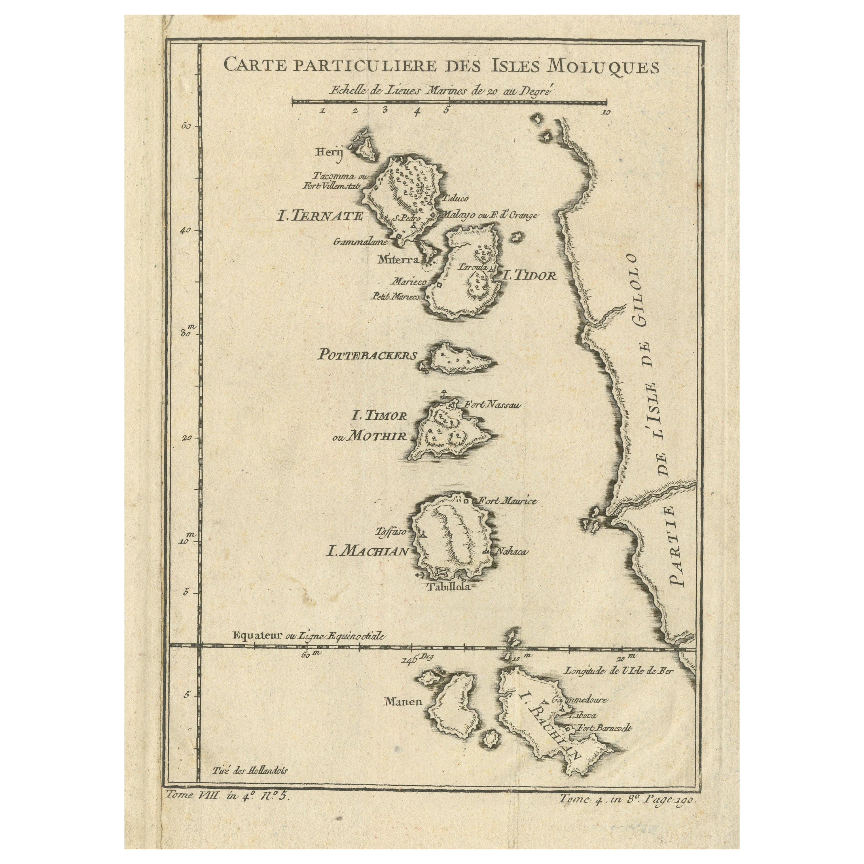
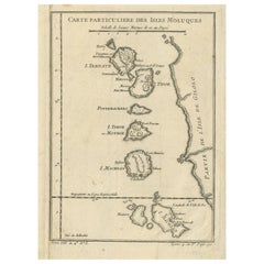
Antique Map of the Maluku Islands or Moluccas, Indonesia
Located in Langweer, NL
Antique map titled 'Carte Particuliere des Isles Moluques'. This map depicts the islands of Herij, Ternate, Tidor, Pottebackers, Timor, Machian and Bachian. The Moluccan islands were...
Category
Antique Mid-18th Century Maps
Materials
Paper
$143 Sale Price
20% Off
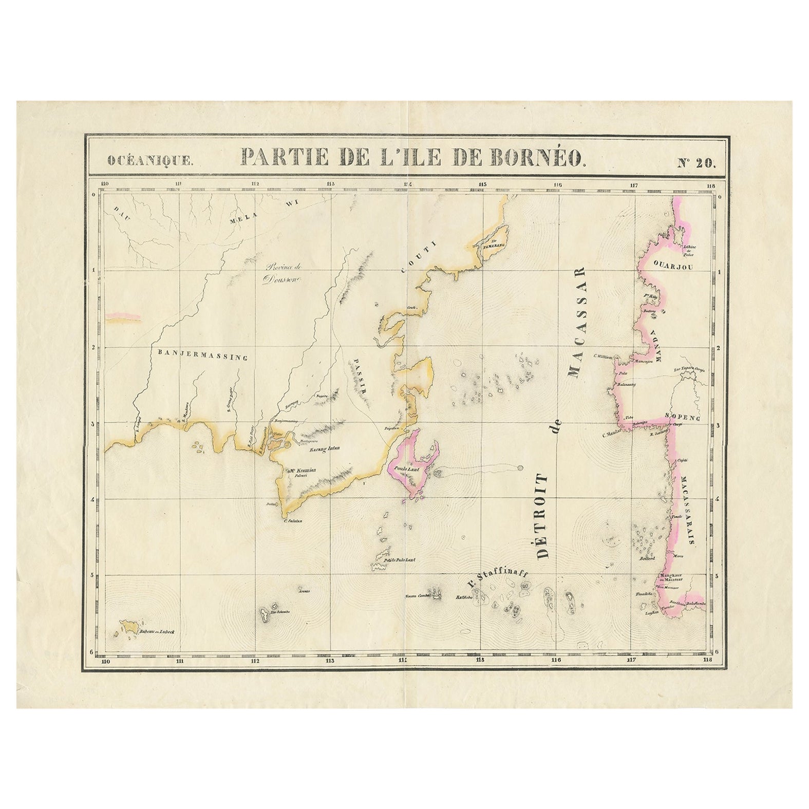
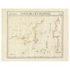
Detailed Antique Map of a Portion of Borneo and Sulawesi in Indonesia, c.1825
Located in Langweer, NL
Antique map titled 'Partie de l'Ile de Bornéo'. Map of a portion of Borneo, primarily the Southern part of the Island, the Strait of Macassar and the Staffinaff Islands. Originates f...
Category
Antique 19th Century Maps
Materials
Paper
$518 Sale Price
20% Off
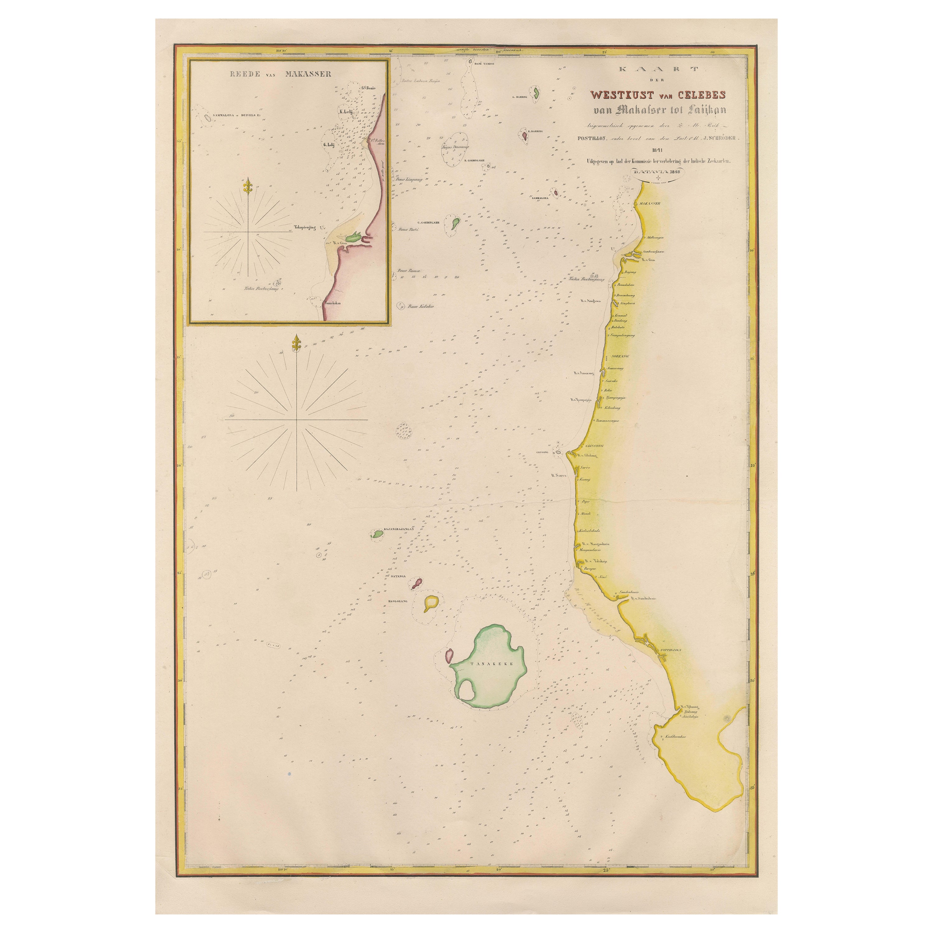
Large Antique Map of the west coast of Celebes, Sulawesi, Indonesia
Located in Langweer, NL
Original antique map titled 'Kaart der Westkust van Celebes van Makasser tot Laijkan'. This large map shows the west coast of Celebes, Sulawesi, Indonesia. It covers the region of Makassar to Cikoang. Inset map of the coast of Selat (Strait) Makassar, also showing the Dutch Fort Rotterdam, to day Fort Ujung Pandang. With historical traces dating back to the Kingdom of Gowa from the 16th century to colonization by the Dutch, this Fort has silently witnessed many episodes in Makassar’s history, playing a most essential role in its development. Originally called Benteng or Fort Jumpandang or Ujung Pandang, the huge complex was first built in 1545 in the era of Imanrigau Daeng Bonto Karaeng Lakiung or Karaeng Tunipalangga Ulaweng, the tenth King of Gowa. Initially, the fort was made from a mixture of Stone and burnt clay, and took the shape of a typical square Portuguese architectural...
Category
Antique Mid-19th Century Maps
Materials
Paper
$412 Sale Price
53% Off
Antique Map of the Indonesian and Philippine Archipelagos by R. de Vaugondy
Located in Langweer, NL
Striking and highly detailed map of the region from Sumatra and Malaca and Southern China to the Philipines, New Guinea and Northern Australia, centered on Borneo. Includes a large i...
Category
Antique Mid-18th Century Maps
Materials
Paper

You May Also Like
Large Original Antique Map of Java and Borneo, Fullarton, C.1870
Located in St Annes, Lancashire
Great map of Java and Borneo
Wonderful figurative borders
From the celebrated Royal Illustrated Atlas
Lithograph. Original color.
Published by Fullarton, Edinburgh. C.1870
Unfr...
Category
Antique 1870s Scottish Maps
Materials
Paper

Original Antique Map of The Philippines. C.1900
Located in St Annes, Lancashire
Fabulous map of The Philippines
Original color.
Engraved and printed by the George F. Cram Company, Indianapolis.
Published, C.1900.
Unframed.
Free shipping.
Category
Antique 1890s American Maps
Materials
Paper

Original Antique Map of South East Asia by Thomas Clerk, 1817
Located in St Annes, Lancashire
Great map of South East Asia
Copper-plate engraving
Drawn and engraved by Thomas Clerk, Edinburgh.
Published by Mackenzie And Dent, 1817
Unframed.
Category
Antique 1810s English Maps
Materials
Paper

Antique French Map of Asia Including China Indoneseia India, 1783
Located in Amsterdam, Noord Holland
Very nice map of Asia. 1783 Dedie au Roy.
Additional information:
Country of Manufacturing: Europe
Period: 18th century Qing (1661 - 1912)
Condition: Overall Condition B (Good Used)...
Category
Antique 18th Century European Maps
Materials
Paper

$486 Sale Price
40% Off
Antique 1803 Italian Map of Asia Including China Indoneseia India
Located in Amsterdam, Noord Holland
Antique 1803 Italian Map of Asia Including China Indoneseia India
Very nice map of Asia. 1803.
Additional information:
Type: Map
Country of Manufacturing: Europe
Period: 19th centu...
Category
Antique 19th Century European Maps
Materials
Paper

$438 Sale Price
39% Off
West Coast of Africa, Guinea
Sierra Leone: An 18th Century Map by Bellin
By Jacques-Nicolas Bellin
Located in Alamo, CA
Jacques Bellin's copper-plate map entitled "Partie de la Coste de Guinee Dupuis la Riviere de Sierra Leona Jusquau Cap das Palmas", depicting the coast of Guinea and Sierra Leone in ...
Category
Antique Mid-18th Century French Maps
Materials
Paper

$460 Sale Price
20% Off
More Ways To Browse
Blue Kilim Vintage
Contemporary Side Tables And Stools
Decorative Wall Plate
Mid Century Modern Corner Chair
Dining Tables With Brass Inlay
Oak Mid Century Armchair
Solid Wood Side Table Stool
Antique Marble Top Hall Table
Bird And Butterfly
Old Carpet
Porcelain Modern Hand Painted
Bent Plywood
1960 Italian Dining Set
Italian Giltwood Table
Polished Bronze Table
Antique Laurel Wreath
Armchair In France
Green Oushak