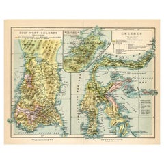
Items Similar to Antique Map of Southern Sulawesi by Stemfoort, 1885


Want more images or videos?
Request additional images or videos from the seller
1 of 10
Antique Map of Southern Sulawesi by Stemfoort, 1885
$407.04
£304.40
€340
CA$560.88
A$611.91
CHF 324
MX$7,332.37
NOK 4,126.32
SEK 3,773.21
DKK 2,589.50
About the Item
"Antique map titled 'Kaart van Zuid West Celebes'. Old map of the southern tip of the southwestern part of Sulawesi. Includes a large inset map of the Makassar area, centered on Fort Rotterdam, with a second inset showing the islands just to the south. This map originates from 'Atlas der Nederlandsche bezittingen in Oost-Indië naar de nieuwste bronnen samengesteld en aan de regering opgedragen'. Artists and Engravers: Author: J.W. Stemfoort.
Artist: Author: J.W. Stemfoort.
Condition: Good, general age-related toning,. Few marginal tears, please study image carefully.
Antique prints have long been appreciated for both their aesthetic and investment value. They were the product of engraved, etched or lithographed plates. These plates were handmade out of wood or metal, which required an incredible level of skill, patience and craftsmanship. Whether you have a house with Victorian furniture or more contemporary decor an old engraving can enhance your living space. We offer a wide range of authentic antique prints for any budget."
- Dimensions:Height: 24.81 in (63 cm)Width: 18.9 in (48 cm)Depth: 0 in (0.01 mm)
- Materials and Techniques:
- Place of Origin:
- Period:
- Date of Manufacture:1885
- Condition:Condition: Good, general age-related toning,. Few marginal tears, please study image carefully.
- Seller Location:Langweer, NL
- Reference Number:Seller: BG-047021stDibs: LU3054327662882
About the Seller
5.0
Recognized Seller
These prestigious sellers are industry leaders and represent the highest echelon for item quality and design.
Platinum Seller
Premium sellers with a 4.7+ rating and 24-hour response times
Established in 2009
1stDibs seller since 2017
2,792 sales on 1stDibs
Typical response time: <1 hour
- ShippingRetrieving quote...Shipping from: Langweer, Netherlands
- Return Policy
More From This Seller
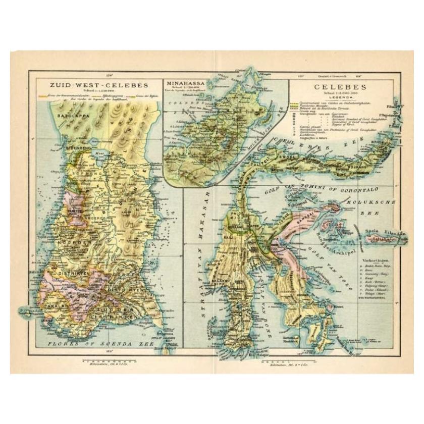
View AllAntique Map of Sulawesi by Winkler Prins, c.1900
Located in Langweer, NL
Antique map titled 'Celebes.' (Sulawesi .) This map shows the Indonesian island of Sulawesi, one of the Sunda islands. With inset maps of South-west Sulawesi and Semenanjung Minahassa. Legend and scale. This map originates from 'De Grote Winkler Prins...
Category
20th Century Maps
Materials
Paper
$69 Sale Price
20% Off
Antique Map of West Sumatra, Indonesia, 1900
Located in Langweer, NL
Antique map titled 'Sumatra, Bangka, Blitoeng en de Riouw-Archipel'. Old map of West Sumatra depicting the various islands and the Strait of Malacca. This map originates from 'Atlas ...
Category
20th Century Maps
Materials
Paper

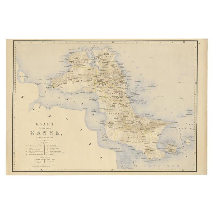
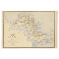
Antique Map of Bangka Island, Indonesia, 1885
Located in Langweer, NL
Antique map titled 'Kaart van het Eiland Banka. Old map of Bangka Island, or Banka. This map originates from 'Atlas der Nederlandsche bezittingen in Oost-Indië naar de nieuwste bronn...
Category
Antique 19th Century Dutch Maps
Materials
Paper
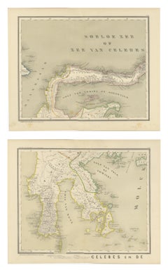
Antique Two-Sheet Map of Celebes Sulawesi - Dornseiffen, Dutch East Indies, 1884
Located in Langweer, NL
Antique Two-Sheet Map of Celebes Sulawesi by Dornseiffen, Published in 1884 - Dutch East Indies
This striking two-sheet antique map set depicts the island of Celebes (modern Sulawes...
Category
Antique 1880s Dutch Maps
Materials
Paper
Antique Map of the Moluccas by Stemfoort, 1885
Located in Langweer, NL
Antique map titled 'Kaart der Molukken'. Old map of the southern tip of the Moluccas, or Maluku Islands. With an inset map of part of Ambon Island and an inset map of New Guinea. Thi...
Category
Antique 19th Century Dutch Maps
Materials
Paper

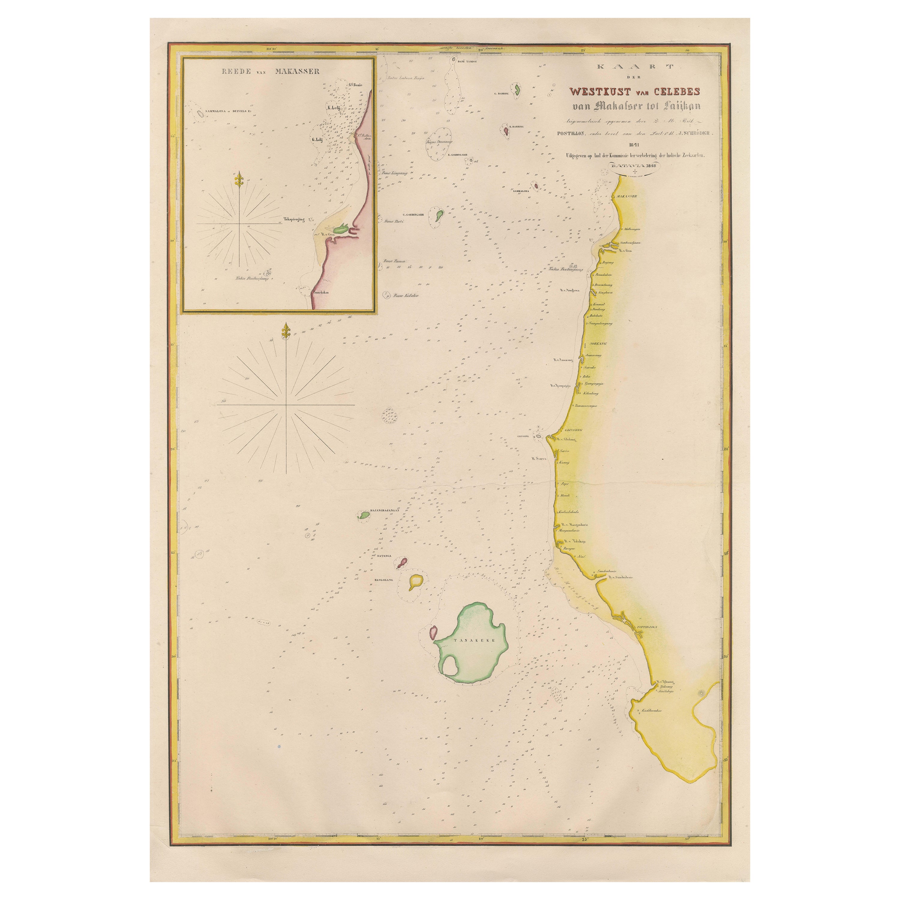
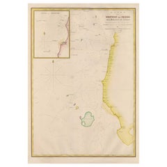
Large Antique Map of the west coast of Celebes, Sulawesi, Indonesia
Located in Langweer, NL
Original antique map titled 'Kaart der Westkust van Celebes van Makasser tot Laijkan'. This large map shows the west coast of Celebes, Sulawesi, Indonesia. It covers the region of Makassar to Cikoang. Inset map of the coast of Selat (Strait) Makassar, also showing the Dutch Fort Rotterdam, to day Fort Ujung Pandang. With historical traces dating back to the Kingdom of Gowa from the 16th century to colonization by the Dutch, this Fort has silently witnessed many episodes in Makassar’s history, playing a most essential role in its development. Originally called Benteng or Fort Jumpandang or Ujung Pandang, the huge complex was first built in 1545 in the era of Imanrigau Daeng Bonto Karaeng Lakiung or Karaeng Tunipalangga Ulaweng, the tenth King of Gowa. Initially, the fort was made from a mixture of Stone and burnt clay, and took the shape of a typical square Portuguese architectural...
Category
Antique Mid-19th Century Maps
Materials
Paper
$411 Sale Price
53% Off
You May Also Like
Large Original Antique Map of Java and Borneo, Fullarton, C.1870
Located in St Annes, Lancashire
Great map of Java and Borneo
Wonderful figurative borders
From the celebrated Royal Illustrated Atlas
Lithograph. Original color.
Published by Fullarton, Edinburgh. C.1870
Unfr...
Category
Antique 1870s Scottish Maps
Materials
Paper

Large Original Antique Map of Madagascar. 1894
Located in St Annes, Lancashire
Superb Antique map of Madagascar
Published Edward Stanford, Charing Cross, London 1894
Original colour
Good condition
Unframed.
Free shipping
Category
Antique 1890s English Maps
Materials
Paper

Large Original Antique Map of the The Windward Islands. 1894
Located in St Annes, Lancashire
Superb Antique map of The Windward Islands
Published Edward Stanford, Charing Cross, London 1894
Original colour
Good condition
Unframed.
Free shipping
Category
Antique 1890s English Maps
Materials
Paper

Large Original Antique Map of The Greek Islands. 1894
Located in St Annes, Lancashire
Superb Antique map of The Greek Islands
Published Edward Stanford, Charing Cross, London 1894
Original colour
Good condition
Unframed.
Free shipping
Category
Antique 1890s English Maps
Materials
Paper

Original Antique Map of South East Asia by Thomas Clerk, 1817
Located in St Annes, Lancashire
Great map of South East Asia
Copper-plate engraving
Drawn and engraved by Thomas Clerk, Edinburgh.
Published by Mackenzie And Dent, 1817
Unframed.
Category
Antique 1810s English Maps
Materials
Paper

Large Original Antique Map of The West Indies by Sidney Hall, 1847
Located in St Annes, Lancashire
Great map of The West Indies
Drawn and engraved by Sidney Hall
Steel engraving
Original colour outline
Published by A & C Black. 1847
Unframed
Free shipping.
Category
Antique 1840s Scottish Maps
Materials
Paper

More Ways To Browse
Ptolemy Map
Antique Maps Massachusetts
Antique Maps Singapore
Antique Planisphere
Map Of Palestine
R Johnston
Santa Cruz Island
Shetland Map
Antique Alabama Map
Antique Framed Map Engravings
Antique Furniture Cheshire
Antique Great Lakes Map
Antique Map Of Michigan
Antique Map Of Turkish Empire
Antique Map Of Yorkshire
Bali Map
Bermuda Map
British Empire Map