Items Similar to Antique Map of Southwest Europe by Kiepert, c.1870


Want more images or videos?
Request additional images or videos from the seller
1 of 5
Antique Map of Southwest Europe by Kiepert, c.1870
$129.37
$161.7120% Off
£96.74
£120.9220% Off
€108
€13520% Off
CA$178.23
CA$222.7920% Off
A$194.39
A$242.9920% Off
CHF 102.97
CHF 128.7220% Off
MX$2,330.46
MX$2,913.0720% Off
NOK 1,311.44
NOK 1,639.3020% Off
SEK 1,199.21
SEK 1,499.0220% Off
DKK 823
DKK 1,028.7520% Off
About the Item
"Antique map titled 'Romanisches Südwest-Europa'. Old map of Southwest Europe. This map originates from 'H. Kiepert's Kleiner Atlas der Neueren Geographie für Schule und Haus'. Artists and Engravers: Kiepert, Heinrich (1818-1899), was a German geographer, and the son of a wealthy businessman.
Artist: Kiepert, Heinrich (1818-1899), was a German geographer, and the son of a wealthy businessman.
Antique prints have long been appreciated for both their aesthetic and investment value. They were the product of engraved, etched or lithographed plates. These plates were handmade out of wood or metal, which required an incredible level of skill, patience and craftsmanship. Whether you have a house with Victorian furniture or more contemporary decor an old engraving can enhance your living space. We offer a wide range of authentic antique prints for any budget.".
- Dimensions:Height: 13.78 in (35 cm)Width: 17.96 in (45.6 cm)Depth: 0 in (0.01 mm)
- Materials and Techniques:
- Period:
- Date of Manufacture:circa 1870
- Condition:Condition: Good, general age-related toning. Split on folding line, please study image carefully.
- Seller Location:Langweer, NL
- Reference Number:Seller: BG-06670-91stDibs: LU3054327674942
About the Seller
5.0
Recognized Seller
These prestigious sellers are industry leaders and represent the highest echelon for item quality and design.
Platinum Seller
Premium sellers with a 4.7+ rating and 24-hour response times
Established in 2009
1stDibs seller since 2017
2,791 sales on 1stDibs
Typical response time: <1 hour
- ShippingRetrieving quote...Shipping from: Langweer, Netherlands
- Return Policy
More From This Seller
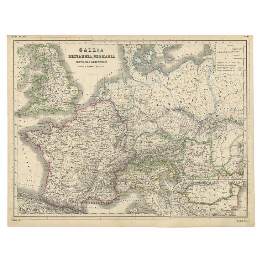
View AllAntique Map of Western Europe by H. Kiepert, circa 1870
By Heinrich Kiepert
Located in Langweer, NL
Antique map titled 'Gallia, Britannia, Germania'. This map depicts a large part of Western Europe including countries like Germany, France, Great Britain, The Netherlands and more. T...
Category
Antique Late 19th Century German Maps
Materials
Paper

Antique Map of Europe by W. G. Blackie, 1859
Located in Langweer, NL
Antique map titled 'Europe'. Original antique map of Europe. This map originates from ‘The Imperial Atlas of Modern Geography’. Published by W. G. Blackie, 1859.
Category
Antique Mid-19th Century Maps
Materials
Paper

$239 Sale Price
20% Off
Antique Map of the European Continent, 1882
Located in Langweer, NL
Antique map titled 'Europe'. Old map of the European continent. This map originates from 'The Royal Atlas of Modern Geography, Exhibiting, in a Series of ...
Category
Antique 19th Century Maps
Materials
Paper

Antique Map of Europe by Johnson,
1872
Located in Langweer, NL
Antique map titled 'Johnson's Europe'. Original map of Europe. This map originates from 'Johnson's New Illustrated Family Atlas of the World' by A.J. Johnson. Published 1872.
Category
Antique Late 19th Century Maps
Materials
Paper

$335 Sale Price
20% Off
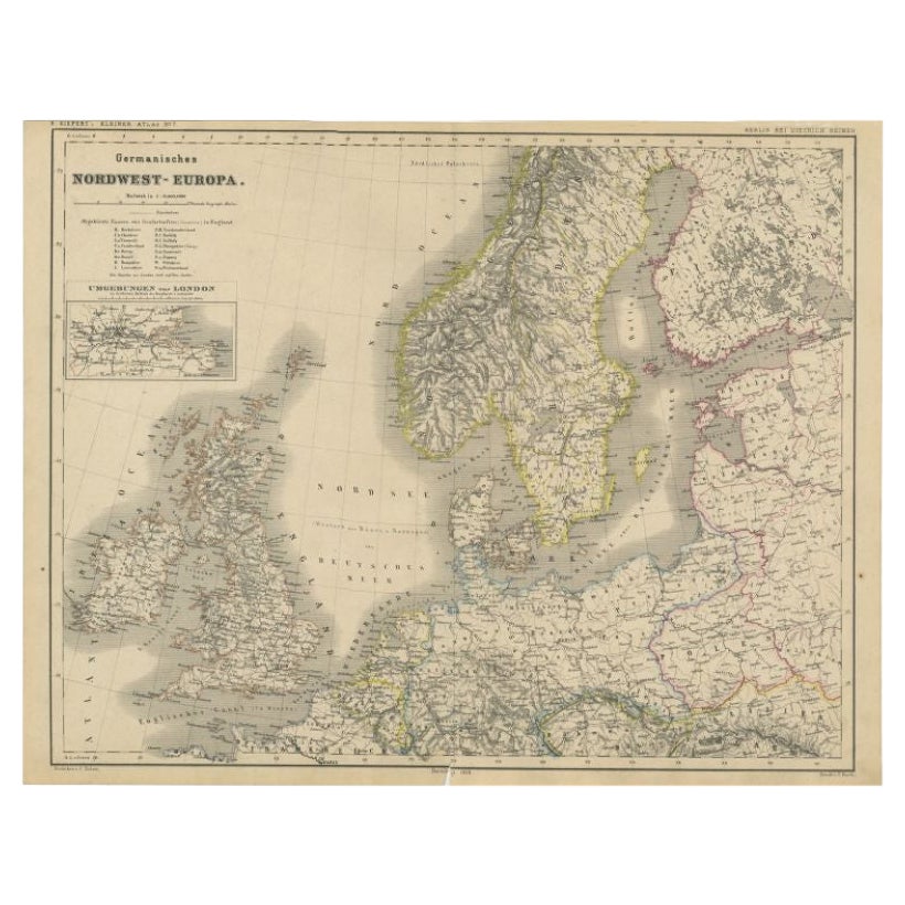
Antique Map of Northwest Europe by Kiepert, c.1870
Located in Langweer, NL
Antique map titled 'Germanisches Nordwest-Europa'. Old map of North-West Europe depicting the United Kingdom, Ireland, the Netherlands, Germany, Scandinavia and surroundings. This ma...
Category
Antique 19th Century Maps
Materials
Paper
$129 Sale Price
20% Off
Original Antique Map of West Europe, circa 1870
Located in Langweer, NL
Antique map titled 'Gallia, Britannia, Germania'. Old map of West Europe including France, Germany and the United Kingdom. This map originates from 'Atlas Antiquus, twaalf kaarten be...
Category
Antique 19th Century German Maps
Materials
Paper
You May Also Like
Large Original Antique Map of Europe by Sidney Hall, 1847
Located in St Annes, Lancashire
Great map of Europe
Drawn and engraved by Sidney Hall
Steel engraving
Original colour outline
Published by A & C Black. 1847
Unframed
Free shipping.
Category
Antique 1840s Scottish Maps
Materials
Paper

Large Original Antique Map of Italy. John Dower, 1861
Located in St Annes, Lancashire
Great map of Italy
Lithograph engraving by John Dower
Original colour
Published, 1861
Unframed
Good condition / repair to top right corner seen in last image
Category
Antique 1860s English Victorian Maps
Materials
Paper

Original Antique Map of Europe, Arrowsmith, 1820
Located in St Annes, Lancashire
Great map of Europe
Drawn under the direction of Arrowsmith.
Copper-plate engraving.
Published by Longman, Hurst, Rees, Orme and Brown, 1820
...
Category
Antique 1820s English Maps
Materials
Paper

Large Original Antique Map of Poland by Sidney Hall, 1847
Located in St Annes, Lancashire
Great map of Poland
Drawn and engraved by Sidney Hall
Steel engraving
Original colour outline
Published by A & C Black. 1847
Unframed
...
Category
Antique 1840s Scottish Maps
Materials
Paper

1870 "Johnson
s Europe" Map Published by A. J. Johnson
Located in Colorado Springs, CO
Presented is an original 1870 "Johnson’s Europe" map. First published in 1864, this map was issued as pages 87 and 88 in the 1870 edition of “Johnson's New Illustrated (Steel Plate) ...
Category
Antique 1870s American Victorian Maps
Materials
Paper

1849 Map of "Europaische Russland",
Meyer Map of European Russia
, Ric. R017
Located in Norton, MA
1849 Map of
"Europaische Russland"
( Meyer Map of European Russia)
Ric.r017
A lovely map of European Russia dating to 1849 by Joseph Meyer. It covers the European portions of...
Category
Antique 19th Century Unknown Maps
Materials
Paper

More Ways To Browse
Southwest Furniture
Ptolemy Map
Antique Maps Massachusetts
Antique Maps Singapore
Antique Planisphere
Map Of Palestine
R Johnston
Santa Cruz Island
Shetland Map
Antique Alabama Map
Antique Framed Map Engravings
Antique Furniture Cheshire
Antique Great Lakes Map
Antique Map Of Michigan
Antique Map Of Turkish Empire
Antique Map Of Yorkshire
Bali Map
Bermuda Map