Items Similar to Antique Map of Spain and Portugal by Barlow, 1809

Want more images or videos?
Request additional images or videos from the seller
1 of 5
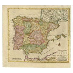
Antique Map of Spain and Portugal by Barlow, 1809
$76.55
$95.6820% Off
£56.84
£71.0520% Off
€64
€8020% Off
CA$105.17
CA$131.4620% Off
A$114.34
A$142.9220% Off
CHF 60.62
CHF 75.7820% Off
MX$1,370.60
MX$1,713.2520% Off
NOK 770.46
NOK 963.0820% Off
SEK 705.85
SEK 882.3120% Off
DKK 487.89
DKK 609.8620% Off
About the Item
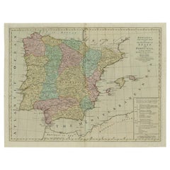
"Antique map titled 'Spain and Portugal from the best Authorities'. Detailed antique map of Spain and Portugal. This map originates from 'The General Gazetteer'. Artists and Engravers: Engraved by Barlow. Published by Brightly and Kennersly.
Artist: Engraved by Barlow. Published by Brightly and Kennersly.
Condition: Very good, original/contemporary hand coloring. Please study image carefully.
Date: 1809
Overall size: 25 x 20 cm.
Image size: 0.001 x 22 x 19 cm.
Antique prints have long been appreciated for both their aesthetic and investment value. They were the product of engraved, etched or lithographed plates. These plates were handmade out of wood or metal, which required an incredible level of skill, patience and craftsmanship. Whether you have a house with Victorian furniture or more contemporary decor an old engraving can enhance your living space. We offer a wide range of authentic antique prints for any budget.".
- Dimensions:Height: 7.88 in (20 cm)Width: 9.85 in (25 cm)Depth: 0 in (0.01 mm)
- Materials and Techniques:
- Period:
- Date of Manufacture:1809
- Condition:
- Seller Location:Langweer, NL
- Reference Number:Seller: BG-093471stDibs: LU3054327675052
About the Seller
5.0
Recognized Seller
These prestigious sellers are industry leaders and represent the highest echelon for item quality and design.
Platinum Seller
Premium sellers with a 4.7+ rating and 24-hour response times
Established in 2009
1stDibs seller since 2017
2,821 sales on 1stDibs
Typical response time: 1 hour
- ShippingRetrieving quote...Shipping from: Langweer, Netherlands
- Return Policy
More From This Seller
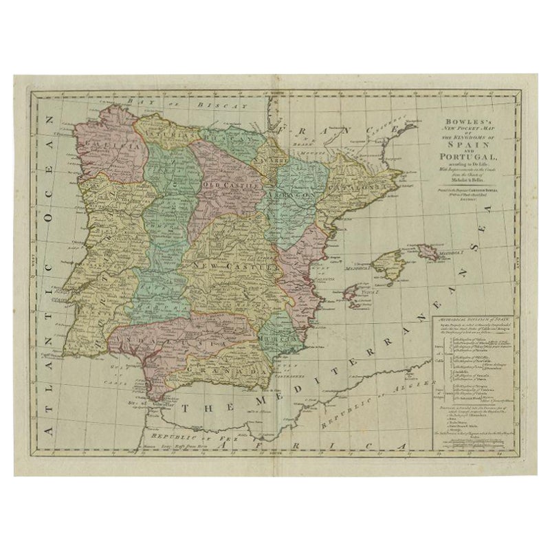
View AllAntique Map of Spain and Portugal by Bowles, c.1780
Located in Langweer, NL
"Antique map titled 'Bowles's New Pocket Map of the Kingdom of Spain and Portugal according to De Lisle'. Large and detailed map of Spain and Portugal. Artists and Engravers: Made by 'Thomas & Carington Bowles' after an anonymous artist. Thomas Bowles, born around 1712, was map publisher and seller in London...
Category
Antique 18th Century Maps
Materials
Paper
Antique Map of Spain and Portugal by Tardieu, circa 1795
Located in Langweer, NL
The image is an antique map titled "Hispanie Betique et Lusitanie", which depicts the Iberian Peninsula during the Roman times, highlighting the provinces of Hispania Baetica (Betiqu...
Category
Antique Late 18th Century Maps
Materials
Paper

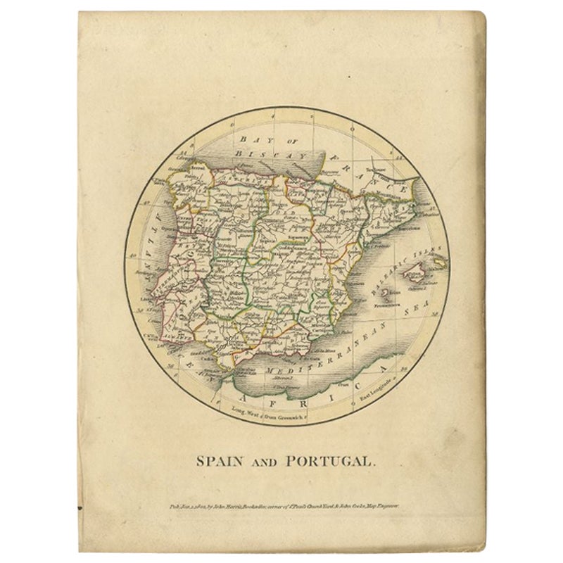
Antique Map of Spain and Portugal by Harris, 1802
Located in Langweer, NL
"Antique map titled 'Spain and Portugal'. Uncommon circular map of Spain and Portugal. Artists and Engravers: Published by J. Harris, 1802.
Artis...
Category
Antique 19th Century Maps
Materials
Paper
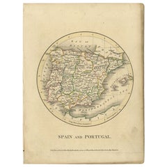
$79 Sale Price
20% Off
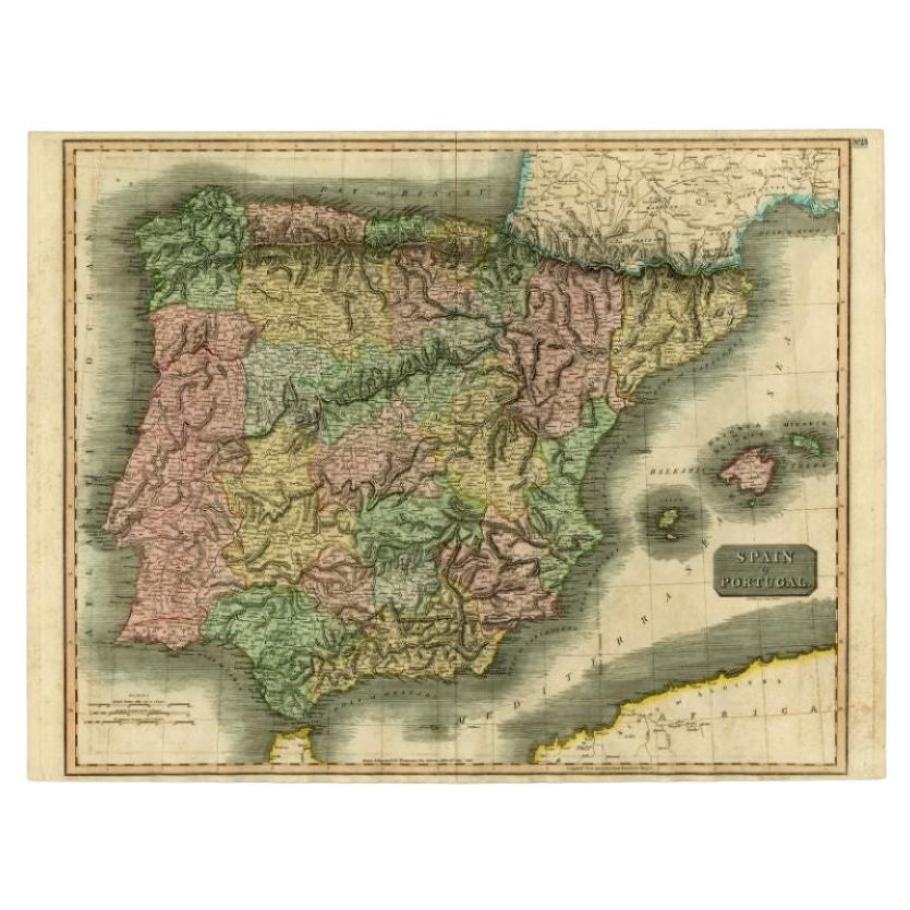
Antique Map of Spain and Portugal by Thomson, 1815
Located in Langweer, NL
Antique map titled 'Spain & Portugal.' Map of Spain and Portugal. From Thomson's 'New General Atlas', 1815. Artists and Engravers: Made by 'J. & G. Menzies'. Publisher: John Thomson ...
Category
Antique 19th Century Maps
Materials
Paper
$167 Sale Price
20% Off
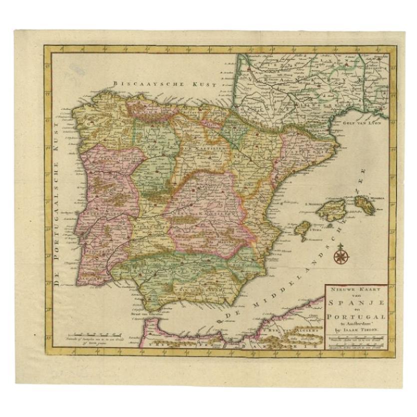
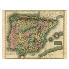
Antique Map of Spain and Portugal by Tirion, c.1760
Located in Langweer, NL
Antique map titled 'Nieuwe Kaart van Spanje en Portugal.' Attractive detailed map showing Spain and Portugal. Including Majorca, Minorca and Ibiza. Title in block-style cartouche wit...
Category
Antique 18th Century Maps
Materials
Paper
$261 Sale Price
20% Off
Antique Map of Spain and Portugal by Keizer
de Lat, 1788
Located in Langweer, NL
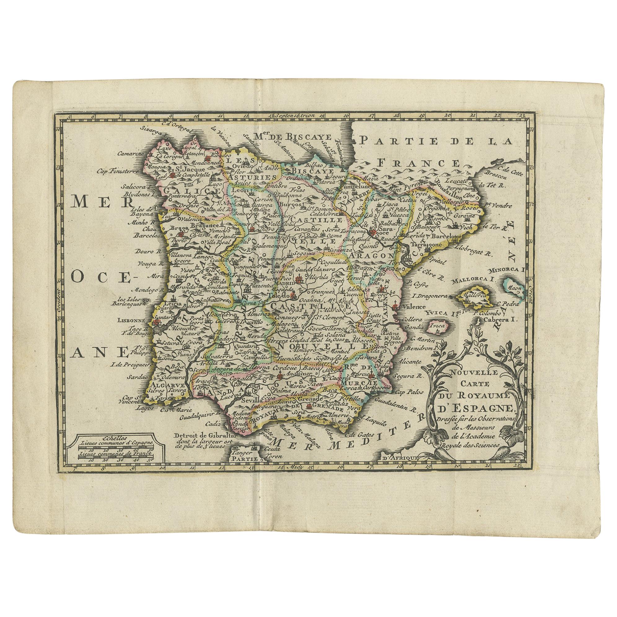
Antique map titled 'Nouvelle Carte du Royaume d'Espagne (..)'. Uncommon original antique map of Spain and Portugal. This map originates from 'Nieuwe Natuur- Geschied- en Handelkundig...
Category
Antique Late 18th Century Maps
Materials
Paper

$334 Sale Price
20% Off
You May Also Like
18th Century Hand Colored Map of Spain and Portugal by Visscher
By Nicolaes Visscher II
Located in Alamo, CA
This is an early 18th century map of Spain and Portugal, with attractive original hand-coloring, entitled "Hispaniae et Portugalliae Regna per Nicolaum Visscher cum Privilegio Ordinu...
Category
Antique Early 18th Century Dutch Maps
Materials
Paper

$1,020 Sale Price
20% Off
Map of Spain and Portugal - Etching by Pierre François Tardieu - 1837
Located in Roma, IT
Map of Spain and Portugal is an Etching realized by Pierre François Tardieu in 1837.
Good conditions.
The artwork is realized in a well-balanced composition. the artwork and belong...
Category
1830s Modern Figurative Prints
Materials
Lithograph

Map of Spain and Portugal - Original Etching - Late 19th Century
Located in Roma, IT
This Map of Spain and Portugal is an etching realized by an anonymous artist.
The state of preservation of the artwork is good with some small diffused stains.
Sheet dimension: 28...
Category
Late 19th Century Modern Figurative Prints
Materials
Etching

Spain and Portugal: A Hand-colored 17th/18th Century Map by Visscher
By Nicolaus Visscher
Located in Alamo, CA
This is an early 18th century map of Spain and Portugal, with attractive original hand-coloring, entitled "Hispaniae et Portugalliae Regna per Nicolaum Visscher cum Privilegio Ordinum Hollandiae et Westfrisiae" first published by Nicolaes Visscher II (1649-1702) in 1688, and later re-published from Visscher's original copper plate by Peter Schenk, Junior in Amsterdam in 1725. The cartouche in the right lower corner depicts a coat of arms representing one combined kingdom of Spain and Portugal before their break-up. Putti hold up the coat-of-arms of Phillip II on the right and a queen reaches for it on the left. There is a scale cartouche in the lower left corner surmounted by two putti and a wheel. This is an outstanding depiction of the Iberian peninsula, showing Spain and Portugal and Balearic Islands. The map includes portions of North Africa and the Strait of Gibralter.
This copperplate engraved map is presented in a cream-colored mat. It is printed on fine chain-linked, laid paper. The mat measures 26.5" high by 30" wide and the sheet measures 21.75" high by 26.375" wide. There is a central fold, as issued. The lower portion of the fold is reinforced on the verso. There is a small paper defect at the lower edge of the fold and another at the edge of the right corner, as well as a few small tears along the lower edge; none affecting the map and all covered by the mat. There are a few small faint spots in the upper margin and on the left. The map is otherwise in very good condition.
The Visscher family were one of the great art and cartographic printing families of the 17th century. Begun by Claes Jansz Visscher...
Category
Late 17th Century Other Art Style Landscape Prints
Materials
Engraving

$1,020 Sale Price
20% Off
After Johann B. Homann (1664-1724) - 19th C, General Map of Spain and Portugal
Located in Corsham, GB
General map of Spain and Portugal divided into its current provinces by D.T. Lopez, newly drawn by F. L. G. in Nuremberg at the Heret of Homann, 1782. A double-page engraved map with...
Category
19th Century More Prints
Materials
Engraving

1751 Map of Spain Castilla Robert De Vaugondy 1st Edition, Ric.a001
Located in Norton, MA
Large Spain Castilla Robert De Vaugondy
1751 1st Edition
-Colored- Ric.a001
Coming from a family of cartographers, a descendant of the famous Nicolas Sanson and ordinary geographer of the king, Gilles Robert de Vaugondy makes himself known by his maps of the French provinces.
He published an Essay on the History of Geography (1755) from which he excluded the physical geography "too systematic". After a Small Atlas (1748), he draws a universal Atlas (1758), a portable Atlas (1762).
His Atlas of the revolutions of the globe remains unpublished. His warnings and prefaces, his book reviews reveal a Cartesian mind and solid knowledge.
Very early, he associates with his works his son Didier who publishes, since 1742, the methodical tables of Nicolas Sanson, two Globes, one terrestrial, the other celestial (1752).
He is credited with a map of Poland...
Category
Antique 18th Century Unknown Maps
Materials
Paper

More Ways To Browse
Ptolemy Map
Antique Maps Massachusetts
Antique Maps Singapore
Antique Planisphere
Map Of Palestine
R Johnston
Santa Cruz Island
Shetland Map
Antique Alabama Map
Antique Framed Map Engravings
Antique Furniture Cheshire
Antique Great Lakes Map
Antique Map Of Michigan
Antique Map Of Turkish Empire
Antique Map Of Yorkshire
Bali Map
Bermuda Map
British Empire Map