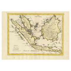
Items Similar to Antique Map of the Sunda Islands Including Sumatra, Java, and Borneo, 1705


Want more images or videos?
Request additional images or videos from the seller
1 of 10
Antique Map of the Sunda Islands Including Sumatra, Java, and Borneo, 1705
$830.11
$1,037.6420% Off
£608.36
£760.4520% Off
€688
€86020% Off
CA$1,139.37
CA$1,424.2120% Off
A$1,203.93
A$1,504.9220% Off
CHF 647.48
CHF 809.3520% Off
MX$14,413.32
MX$18,016.6420% Off
NOK 8,112.19
NOK 10,140.2320% Off
SEK 7,429.58
SEK 9,286.9820% Off
DKK 5,241.33
DKK 6,551.6620% Off
About the Item
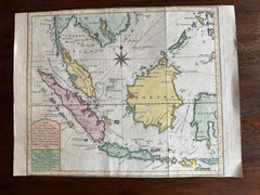
Title: “Antique Map of the Sunda Islands Including Sumatra, Java, and Borneo”
This print is a beautifully detailed and relatively rare map of Western Indonesia, encompassing the region historically known as the Sunda Islands. Created by the cartographer Nicolas Sanson and published in 1705, it measures approximately 9.8 x 7.6 inches (24.9 x 19.3 cm). The map features hand-applied coloring, enhancing its visual appeal and highlighting the distinctive geographical features of the Malay Peninsula, Sumatra, Java, and Borneo, among others.
The map is noteworthy for its precision and the abundance of place names, such as Sincapura (Singapore), Bali, Flores, and others, which are meticulously noted. A striking feature of this map is its ornate title cartouche, adorned with a garland of fruit, which adds an artistic element to the scientific endeavor of cartography.
Nicolas Sanson's small maps, originally from his work "L'Asie en Plusieurs Cartes..." first published in 1652 and engraved by A. Peyrounin, were popular and influential enough to be replicated by various publishers. Johann David Zunners included copies of Sanson's maps in his German translation of "Die Gantze Erd-Kugel" in 1679. Johannes Ribbius and Simon de Vries also published copies in 1682 and 1683, introducing new maps engraved by Antoine d'Winter.
The engraving plates changed hands over time, eventually being acquired by Francois Halma, who utilized them in 1699 and later in 1705, with the titles being re-engraved in Dutch. These same plates saw further use, with titles re-engraved back into French for use by Nicholas Chemereau in 1715 and Henri du Sauzet in 1738.
This map, originating from "Algemeene Weereld-Beschryving," represents a significant period in cartographic history, illustrating the era's geographical knowledge and artistic flair. The intricate detailing and the charming coloration of the map make it not only an important historical document but also a piece of art.
- Dimensions:Height: 8.67 in (22 cm)Width: 11.89 in (30.2 cm)Depth: 0 in (0.02 mm)
- Materials and Techniques:Paper,Engraved
- Period:1700-1709
- Date of Manufacture:1705
- Condition:Very good. A dark and attractive impression on a bright sheet with a bit of offsetting and a narrow top margin. Study the scans carefully.`.
- Seller Location:Langweer, NL
- Reference Number:Seller: BG-137241stDibs: LU3054338602972
About the Seller
5.0
Recognized Seller
These prestigious sellers are industry leaders and represent the highest echelon for item quality and design.
Platinum Seller
Premium sellers with a 4.7+ rating and 24-hour response times
Established in 2009
1stDibs seller since 2017
2,852 sales on 1stDibs
Typical response time: 1 hour
- ShippingRetrieving quote...Shipping from: Langweer, Netherlands
- Return Policy
More From This Seller
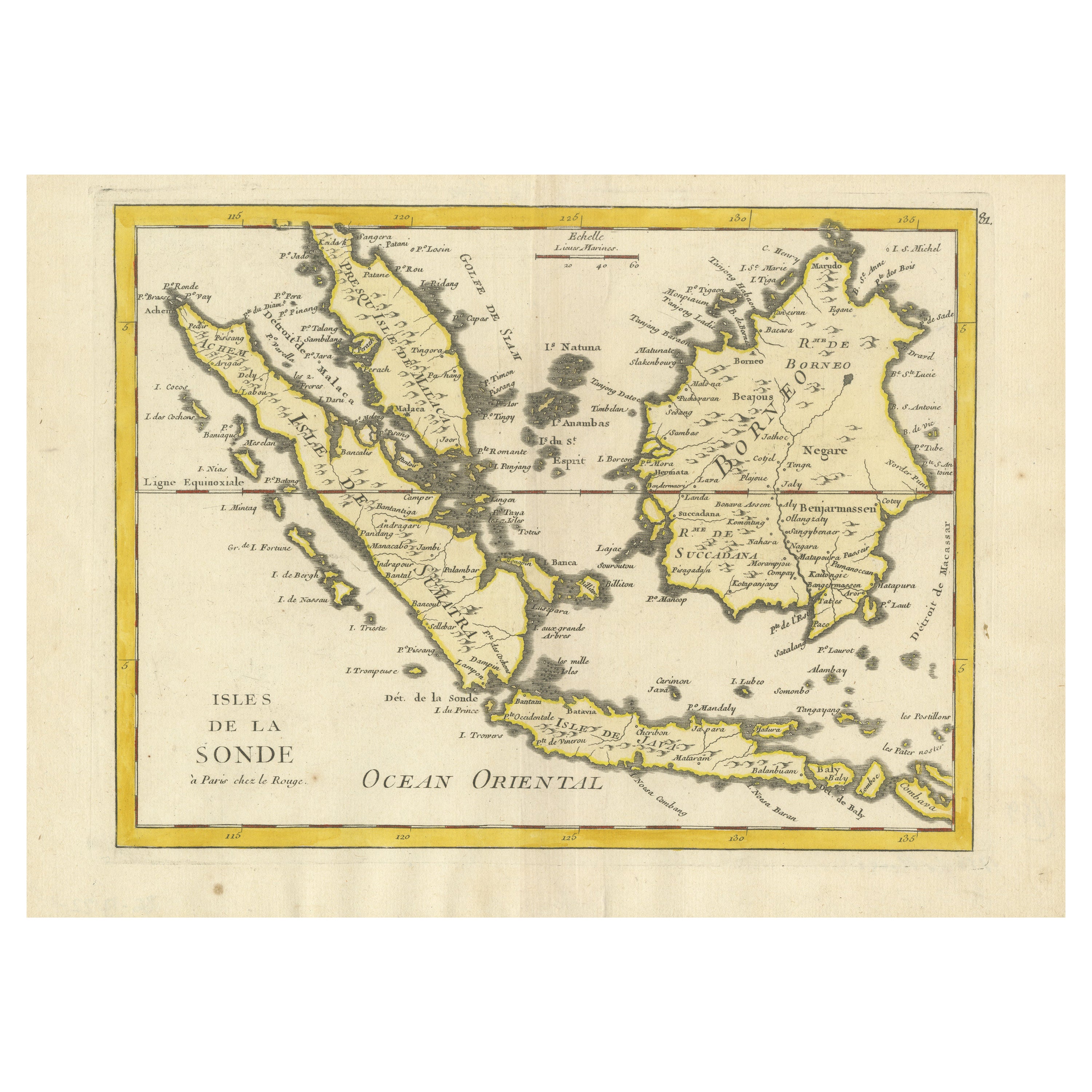
View AllAntique Map of the Sunda Islands Sumatra, Java, Malay Peninsula
Borneo (1739)
By Isaak Tirion
Located in Langweer, NL
Antique map titled 'Nieuwe kaart van de Sundasche Eilanden als Borneo, Sumatra en Groot Iava & c'. Detailed map of the Sunda Islands, Southeast Asia, extending from the tip of Cambod...
Category
Antique Mid-18th Century Maps
Materials
Paper

$705 Sale Price
21% Off
Old Original Antique Map of the Sunda Islands of Indonesia, 1756
Located in Langweer, NL
Title: Isles De La Sonde.
Attractive old decorative map of the Isles de la Sonde, Borneo, Sumatra, Java and Malacca ( Malaysia) with the Straits of Malacca. Penang is spelled as P...
Category
Antique 1750s French Maps
Materials
Paper
$530 Sale Price
20% Off
Rare Antique Map of the Dutch East Indies
Indonesia
, 1774
Located in Langweer, NL
Rare decorative engraved map of the Dutch East Indies, or nowadays Indonesia.
Title (in old Dutch): NIEUWE EN NAUKEURIGE KAART DER OOST-INDISCHE ...
Category
Antique 1770s Maps
Materials
Paper

$1,158 Sale Price
20% Off
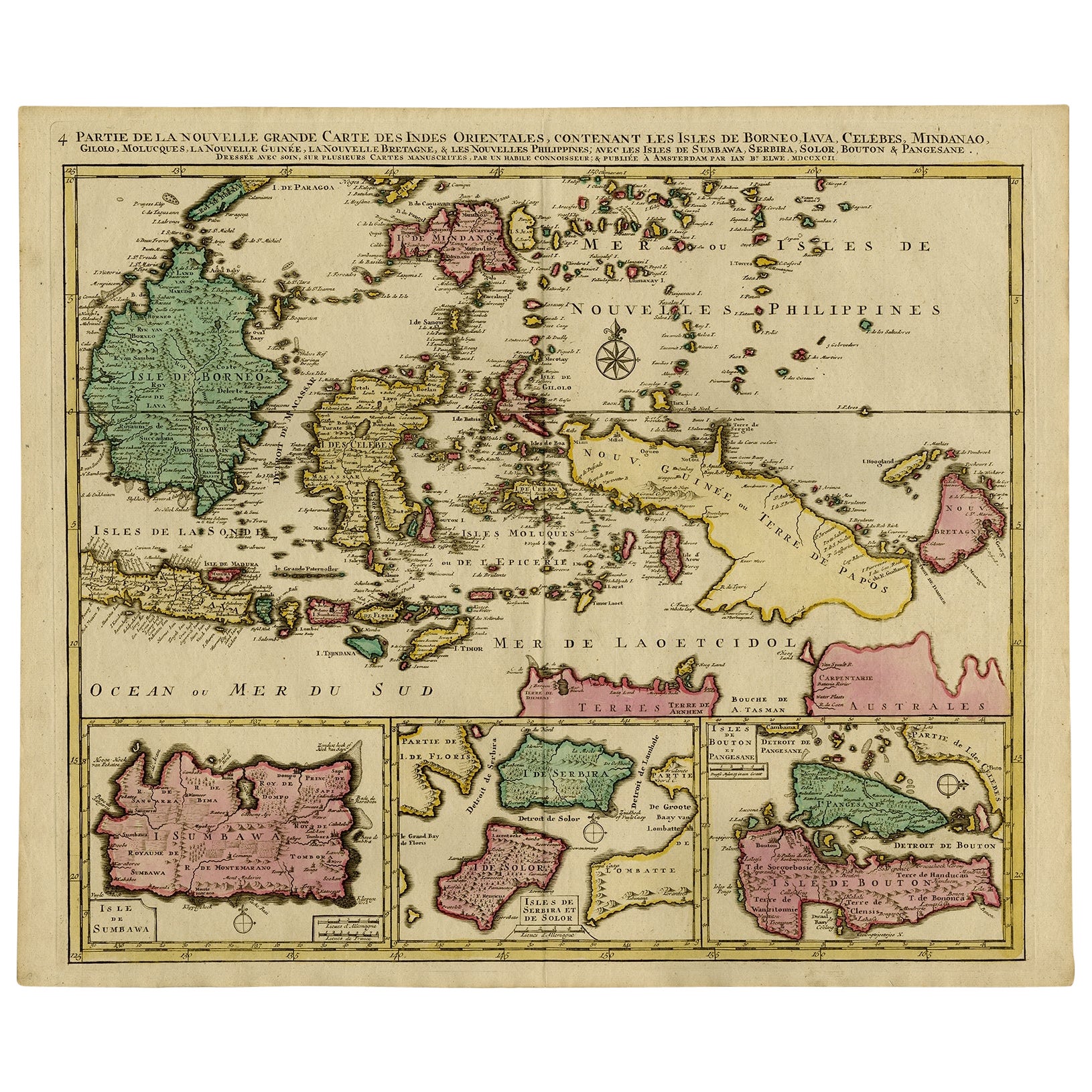
Old Map of Indonesian Islands Borneo, Celebes, New Guinea
New Britain, 1792
Located in Langweer, NL
Antique map titled 'Partie de la Nouvelle Grande Carte des Indes Orientales, contenant les Isles de Borneo, Iava, Celebes, Mindanao (..)'.
Detailed map of the Indonesian islands Bo...
Category
Antique 1790s French Maps
Materials
Paper

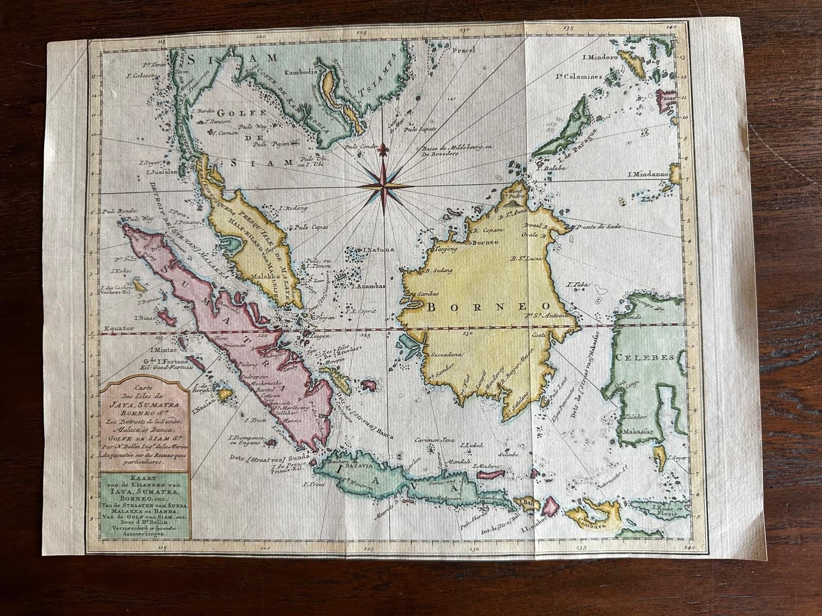
Original Map of the East Indies Including Sumatra, Java, Borneo
Malaysia, 1755
Located in Langweer, NL
TitlEast Indies map – Java, Sumatra, Borneo & Malay Peninsula, c.1755
Attractive 18th-century map of the East Indies centered on Borneo and the Malay world, showing Sumatra, Java, t...
Category
Antique 1750s Dutch Maps
Materials
Paper
Antique Map of Southeast Asia from Persia to the Timor Island, 1712
Located in Langweer, NL
Antique map titled 'A New Map of the East Indies'.
Old map covering all of Southeast Asia from Persia to the Timor Island, inclusive of the modern day nations of India, Ceylon, T...
Category
Antique 1710s Maps
Materials
Paper

$762 Sale Price
20% Off
You May Also Like
Map of the East Indies: An Original 18th Century Hand-colored Map by E. Bowen
Located in Alamo, CA
This is an original 18th century hand-colored map entitled "An Accurate Map of the East Indies Exhibiting the Course of the European Trade both on the Continent and Islands" by Emanu...
Category
Mid-18th Century Old Masters Landscape Prints
Materials
Engraving

Antique French Map of Asia Including China Indoneseia India, 1783
Located in Amsterdam, Noord Holland
Very nice map of Asia. 1783 Dedie au Roy.
Additional information:
Country of Manufacturing: Europe
Period: 18th century Qing (1661 - 1912)
Condition: Overall Condition B (Good Used)...
Category
Antique 18th Century European Maps
Materials
Paper

$486 Sale Price
40% Off
Antique 1803 Italian Map of Asia Including China Indoneseia India
Located in Amsterdam, Noord Holland
Antique 1803 Italian Map of Asia Including China Indoneseia India
Very nice map of Asia. 1803.
Additional information:
Type: Map
Country of Manufacturing: Europe
Period: 19th centu...
Category
Antique 19th Century European Maps
Materials
Paper

$438 Sale Price
39% Off
Original Antique Map of South East Asia by Thomas Clerk, 1817
Located in St Annes, Lancashire
Great map of South East Asia
Copper-plate engraving
Drawn and engraved by Thomas Clerk, Edinburgh.
Published by Mackenzie And Dent, 1817
Unframed.
Category
Antique 1810s English Maps
Materials
Paper

Southern Greece: A Large 17th C. Hand-colored Map by Sanson and Jaillot
By Nicolas Sanson
Located in Alamo, CA
This large original hand-colored copperplate engraved map of southern Greece and the Pelopponese Peninsula entitled "La Moree Et Les Isles De Zante, Cefalonie, Ste. Marie, Cerigo & C...
Category
Antique 1690s French Maps
Materials
Paper

Antique Map - Mare Pacificum - Etching by Johannes Janssonius - 1650s
By Johannes Janssonius
Located in Roma, IT
Mare Pacificum is an antique map realized in 1650 by Johannes Janssonius (1588-1664).
The Map is Hand-colored etching, with coeval watercolorang.
Good conditions with slight foxing...
Category
1650s Modern Figurative Prints
Materials
Etching

More Ways To Browse
Antique Engraving Plates
Bali Antique
Singapore Antique
19th Century Round Dining Table
Carved Chinese Tables
Mid Century Modern Danish Teak Dining Tables
Long Rug Runners
Pair Arm Chairs
Sterling Silver Dinner Sets
United Chair Company
British Antiques
Italian Beech Chairs
Shirvan Rugs
Spain Marble
Vintage Brown Bottles
Vintage Danish Tables And Chairs
1960s Glass Top Coffee Table
Black Glass Coffee Tables