Items Similar to Antique Map of Tibet, The Gobi Desert and China by Bellin, circa 1764


Want more images or videos?
Request additional images or videos from the seller
1 of 10
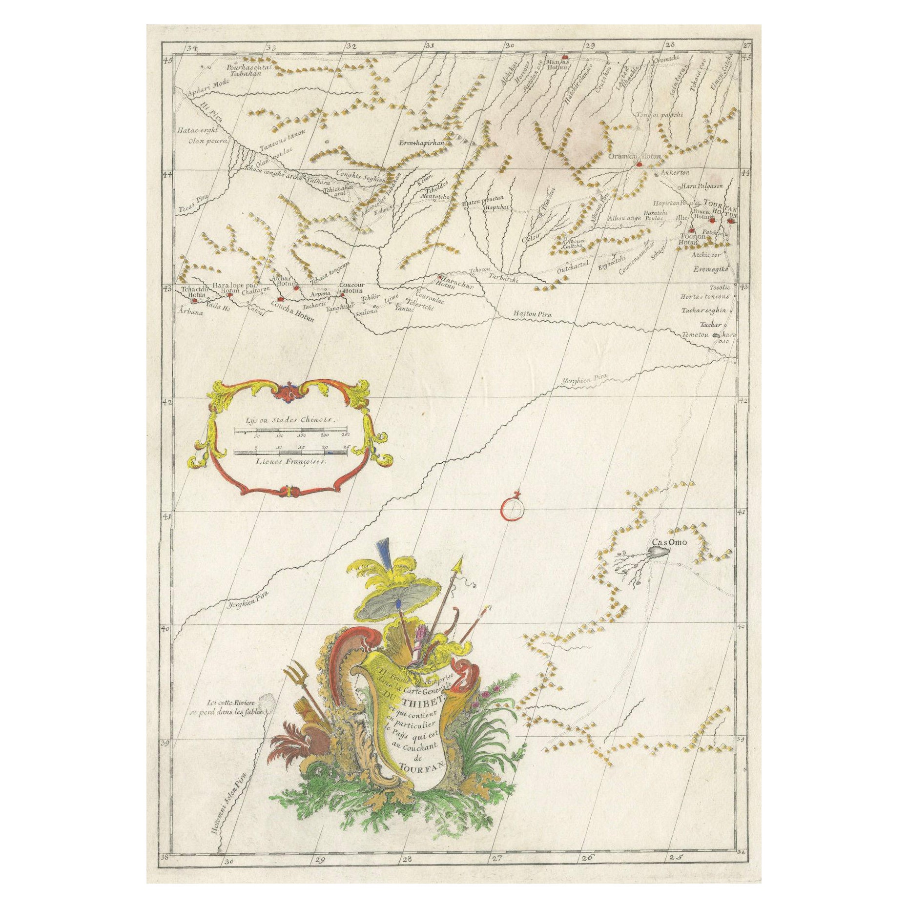
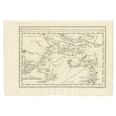
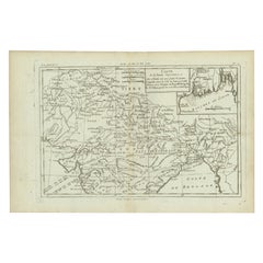
Antique Map of Tibet, The Gobi Desert and China by Bellin, circa 1764
$396.33
£293.58
€330
CA$542.28
A$590.04
CHF 312.42
MX$7,098.58
NOK 3,967.02
SEK 3,629.55
DKK 2,514.87
About the Item
Antique map titled 'Carte de l'Empire de Hya et Partie de Tangut'. Old map of Tibet, Gobi desert and China depicting the Great Wall of China and caravan routes. Originates from Prevost d'Exiles influential travel book, 'L'Histoire Generale des Voyages'.
Artists and Engravers: Jacques-Nicolas Bellin (1703-1772) was among the most important mapmakers of the eighteenth century. In 1721, at age 18, he was appointed hydrographer (chief cartographer) to the French Navy. In August 1741, he became the first Ingénieur de la Marine of the Depot des cartes et plans de la Marine (the French Hydrographic Office) and was named Official Hydrographer of the French King.
Condition: Very good, please study image carefully.
Date: circa 1764
Overall size: 40.5 x 27 cm.
Image size: 31 x 22 cm.
We sell original antique maps to collectors, historians, educators and interior decorators all over the world. Our collection includes a wide range of authentic antique maps from the 16th to the 20th centuries. Buying and collecting antique maps is a tradition that goes back hundreds of years. Antique maps have proved a richly rewarding investment over the past decade, thanks to a growing appreciation of their unique historical appeal. Today the decorative qualities of antique maps are widely recognized by interior designers who appreciate their beauty and design flexibility. Depending on the individual map, presentation, and context, a rare or antique map can be modern, traditional, abstract, figurative, serious or whimsical. We offer a wide range of authentic antique maps for any budget.
- Dimensions:Height: 10.63 in (27 cm)Width: 15.95 in (40.5 cm)Depth: 0.01 in (0.2 mm)
- Materials and Techniques:Paper,Engraved
- Place of Origin:
- Period:
- Date of Manufacture:circa 1764
- Condition:Condition: Very good, please study image carefully.
- Seller Location:Langweer, NL
- Reference Number:Seller: BGJC-0501stDibs: LU3054329305292
About the Seller
5.0
Recognized Seller
These prestigious sellers are industry leaders and represent the highest echelon for item quality and design.
Platinum Seller
Premium sellers with a 4.7+ rating and 24-hour response times
Established in 2009
1stDibs seller since 2017
2,816 sales on 1stDibs
Typical response time: 1 hour
- ShippingRetrieving quote...Shipping from: Langweer, Netherlands
- Return Policy
More From This Seller
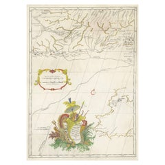
View AllAntique Map of the Bukhari and Surroundings by Bellin, 1749
Located in Langweer, NL
Antique map titled 'Carte de la Petite Bukharie et Pays Voisins'. Old map of the Bukhari (Sinkiang in north-western China) and neighboring countries. Artists and Engravers: Jacques-N...
Category
Antique 18th Century Maps
Materials
Paper
$134 Sale Price
20% Off
Antique Map of Tibet and Region West of Turfan by D’Anville, Paris, 1737
Located in Langweer, NL
Antique Map of Tibet and Region West of Turfan by D’Anville, Paris, 1737
This finely engraved map is one of the detailed sheets from Jean-Baptiste Bourguignon d’Anville’s Carte géné...
Category
Antique 1730s French Maps
Materials
Paper
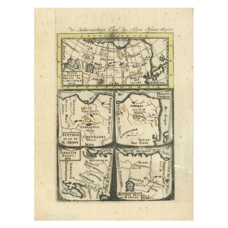
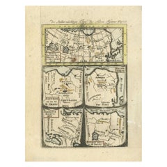
Antique Map of Northern Asia by Mallet, 1719
Located in Langweer, NL
Antique map titled 'Das Mitternächtige Theil des Alten Asien'. This sheet of five miniature maps describes the northern part of Asia in classical times, perhaps circa 150 AD. At the top, an overview map shows the main regions and territories, which are pictured in more detail below. From left to right, the four maps below depict Scythia east of the Imaus (Pamir) Mountains, Serica, Sychia west of the Pamir mountains, and Sarmatia, the last of which borders the Black Sea. Originates from Alain Manesson Mallet's 'Description de l 'Univers' (German edition). Artists and Engravers: Alain Manesson Mallet (1630-1706) was a French cartographer and engineer. He started his career as a soldier in the army of Louis XIV, became a Sergeant-Major in the artillery and an Inspector of Fortifications. He also served under the King of Portugal, before returning to France, and his appointment to the court of Louis XIV. His military engineering and mathematical background led to his position teaching mathematics at court. His major publications were Description de L'Univers (1683) in 5 volumes, and Les Travaux de Mars ou l'Art de la Guerre (1684) in 3 volumes. His Description de L'Universe contains a wide variety of information, including star maps...
Category
Antique 18th Century Maps
Materials
Paper
$93 Sale Price
20% Off
Antique Map of Western Tartary and the Gobi Desert of the Russian Empire, c.1750
Located in Langweer, NL
Antique map titled 'A Map of Western Tartary Drawn from the Survey of the Jesuits and Mr. Kyrillow's Map of the Russian Empire'. Map of the Gobi Desert and the eastern portion of the...
Category
Antique 18th Century Maps
Materials
Paper

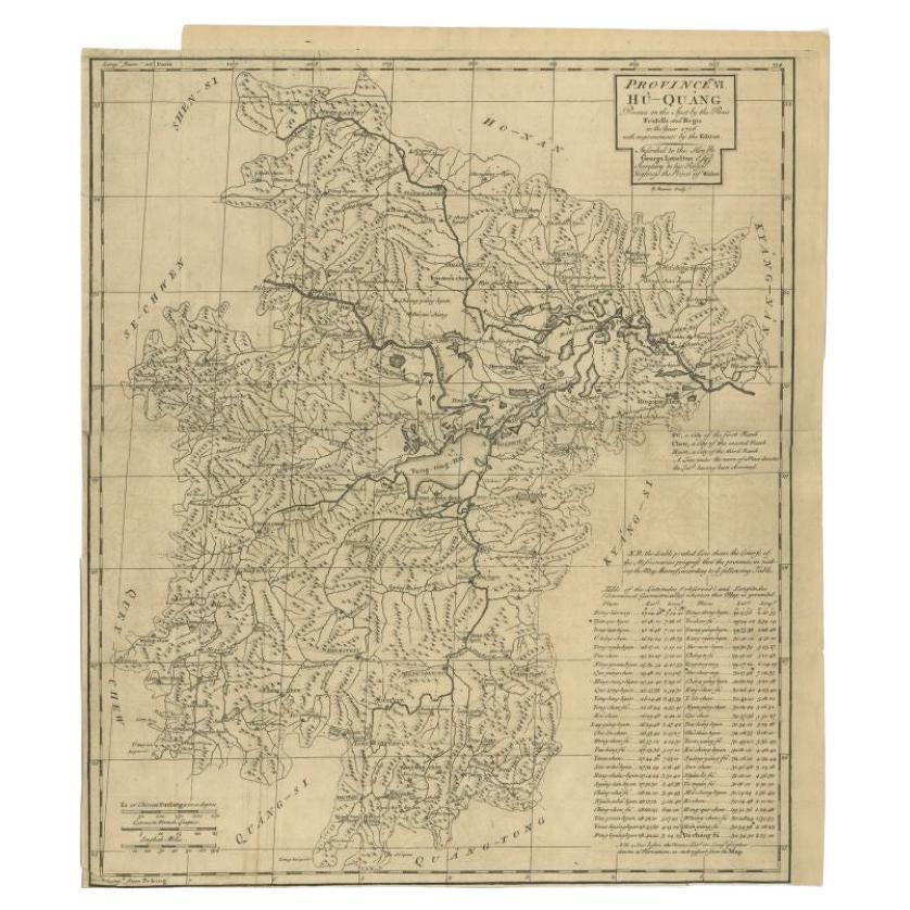
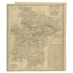
Antique Map of the Huguang Province of China by Du Halde, 1738
Located in Langweer, NL
Antique map titled 'Province VI Hu-Quang'. Old map depicting the Huguang province of China. Originates from 'A description of the Empire of China and Chinese-Tartary' by by J.B. du H...
Category
Antique 18th Century Maps
Materials
Paper
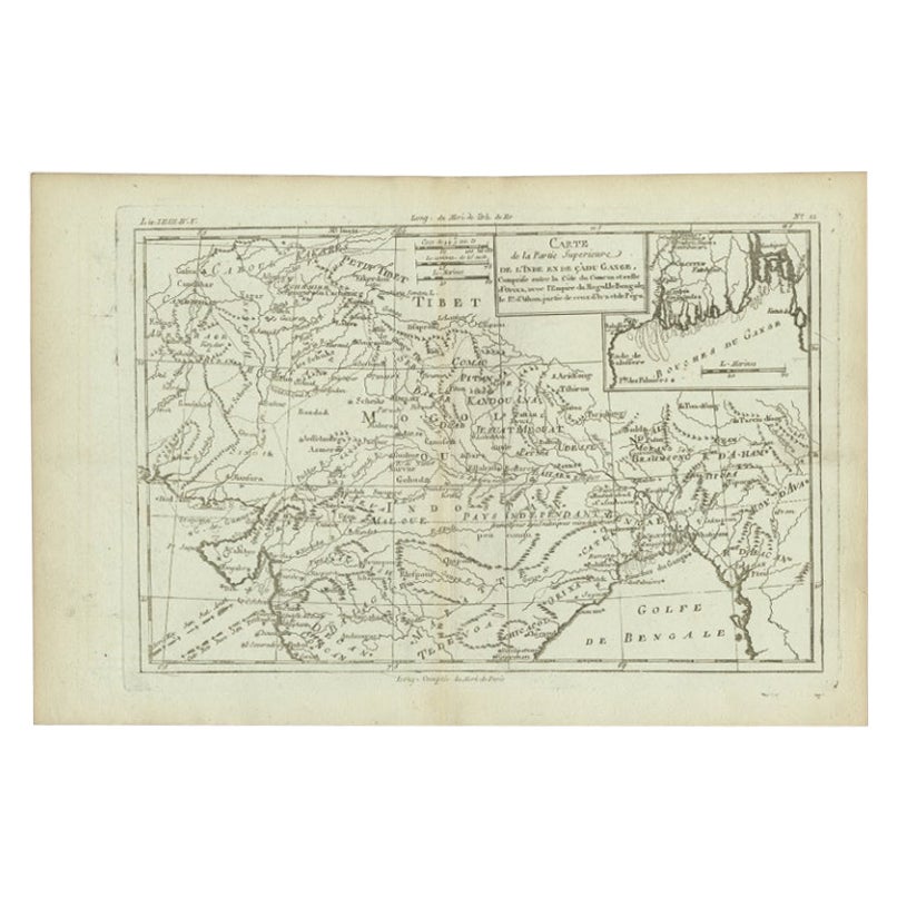
Antique Map of Part of Southern Asia by Bonne, c.1780
Located in Langweer, NL
Antique map titled 'Carte de la Partie Superieure de l'Inde en deca du Gange. Comprise entre la Cote du Concan et celle d'Orixa, avec l'Empire du Mogol, le Bengale, le R. d'Asham, pa...
Category
Antique 18th Century Maps
Materials
Paper
$120 Sale Price
20% Off
You May Also Like
Super Rare Antique French Map of Chine and the Chinese Empire, 1780
Located in Amsterdam, Noord Holland
Super Rare Antique French Map of Chine and the Chinese Empire, 1780
Very nice map of Asia. 1780 Made by Bonne.
Additional information:
Type: Map
...
Category
Antique 18th Century European Maps
Materials
Paper

$438 Sale Price
49% Off
Antique French Map of Asia Including China Indoneseia India, 1783
Located in Amsterdam, Noord Holland
Very nice map of Asia. 1783 Dedie au Roy.
Additional information:
Country of Manufacturing: Europe
Period: 18th century Qing (1661 - 1912)
Condition: Overall Condition B (Good Used)...
Category
Antique 18th Century European Maps
Materials
Paper

$486 Sale Price
40% Off
Antique 1803 Italian Map of Asia Including China Indoneseia India
Located in Amsterdam, Noord Holland
Antique 1803 Italian Map of Asia Including China Indoneseia India
Very nice map of Asia. 1803.
Additional information:
Type: Map
Country of Manufacturing: Europe
Period: 19th centu...
Category
Antique 19th Century European Maps
Materials
Paper

$438 Sale Price
39% Off
Original Antique Map of China, Arrowsmith, 1820
Located in St Annes, Lancashire
Great map of China
Drawn under the direction of Arrowsmith
Copper-plate engraving
Published by Longman, Hurst, Rees, Orme and Brown, 1820
Unfr...
Category
Antique 1820s English Maps
Materials
Paper

Original Antique Map of South America. C.1780
Located in St Annes, Lancashire
Great map of South America
Copper-plate engraving
Published C.1780
Two small worm holes to left side of map
Unframed.
Category
Antique Early 1800s English Georgian Maps
Materials
Paper

California, Alaska and Mexico: 18th Century Hand-Colored Map by de Vaugondy
By Didier Robert de Vaugondy
Located in Alamo, CA
This is an 18th century hand-colored map of the western portions of North America entitled "Carte de la Californie et des Pays Nord-Ouest separés de l'Asie par le détroit d'Anian, ex...
Category
Antique 1770s French Maps
Materials
Paper

More Ways To Browse
Tibet Antiques
Great Wall China
Gibraltar Antique Map
Guyana Antique Map
Maps Of New Mexico
Saudi Arabia Map
16th Century Scotland
Antique Leather Map
Antique Map Of Argentina
Antique Map Of Colombia
Cornwall Map
Early Texas Furniture
Iraq Map
James Cook Map
Kentucky Antiques
Map Of Mexican California
Montreal Map
Mughal Map