Items Similar to Antique Map of Tibet and Latac by D’Anville, Paris, 1737


Want more images or videos?
Request additional images or videos from the seller
1 of 10
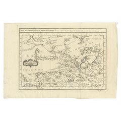
Antique Map of Tibet and Latac by D’Anville, Paris, 1737
$276.23
£204.61
€230
CA$377.95
A$411.24
CHF 217.75
MX$4,947.50
NOK 2,764.89
SEK 2,529.68
DKK 1,752.79
About the Item
Antique Map of Tibet and Latac by D’Anville, Paris, 1737
This antique engraved map is the ninth and final sheet of Jean-Baptiste Bourguignon d’Anville’s monumental Carte générale du Thibet, first published in Paris in 1737. The title cartouche reads “IXe et dernière feuille de celles qui sont comprises dans la Carte générale du Thibet, et où se trouve Latac,” marking it as the concluding portion of the larger atlas.
The map covers the borderlands of Tibet, Ladakh, and Mongolia, an area of great geographical and cultural significance in the 18th century. Prominently featured are the *Ganga River system*, with several branches flowing across the sheet, and key locations including Latac Volerce, Tchoumourti, Piti, and the lake labeled Rudocung Suma. Mountain ranges are depicted pictorially in shaded relief, while numerous political boundaries are noted, including Limites de Monpa Pitai, Monpa Kenti, Monpa Nontai, and Monda Dsomlangu.
The decorative rococo-style cartouche at the top, delicately hand-colored, adds elegance to the map and reflects the French engravers’ artistic sensibilities. At the bottom margin, the note Anonkeek (or Anongen) places the region within the broader dominion of the Mongol empire (Mogol), showing the cartographer’s effort to situate Tibetan territories within the political geography of Eurasia as understood at the time.
D’Anville’s maps were groundbreaking for their reliance on first-hand surveys and missionary accounts, discarding many speculative traditions that had dominated earlier European cartography. His Atlas de la Chine, de la Tartarie Chinoise et du Thibet (1737), from which this sheet originates, was based on the surveys of Jesuit missionaries commissioned by the Chinese Emperor Kangxi. As a result, these maps were among the most accurate European depictions of Central Asia of the 18th century and remained authoritative for decades.
This sheet is a fine example of 18th-century French scientific cartography, merging precise geography with decorative artistry. It represents not only a historical view of Tibet and its frontiers but also the Enlightenment spirit of exploration and knowledge.
Condition report:
Fair to Good condition with a strong, clean impression. Hand-coloring to cartouche and select details remains fresh. Light toning and faint handling marks in the margins, with a chip out of the lower left corner. Ample margins preserved.
Framing tips:
A simple dark wood or walnut frame with a wide cream or ivory mat will emphasize the map’s delicate hand-coloring and engraved detail. For a more formal presentation, a gilt frame with a subtle inner fillet would echo the elegance of the rococo cartouche.
Technique: Engraving with hand-coloring
Maker: Jean-Baptiste Bourguignon d’Anville, Paris, 1737
- Dimensions:Height: 20.67 in (52.5 cm)Width: 13.12 in (33.3 cm)Depth: 0.01 in (0.2 mm)
- Materials and Techniques:Paper,Engraved
- Place of Origin:
- Period:1730-1739
- Date of Manufacture:1737
- Condition:Fair to Good condition with a strong, clean impression. Hand-coloring to cartouche and select details remains fresh. Light toning and faint handling marks in the margins, with a chip out of the lower left corner. Ample margins preserved.
- Seller Location:Langweer, NL
- Reference Number:Seller: BG-13457-11stDibs: LU3054346743672
About the Seller
5.0
Recognized Seller
These prestigious sellers are industry leaders and represent the highest echelon for item quality and design.
Platinum Seller
Premium sellers with a 4.7+ rating and 24-hour response times
Established in 2009
1stDibs seller since 2017
2,816 sales on 1stDibs
Typical response time: 1 hour
- ShippingRetrieving quote...Shipping from: Langweer, Netherlands
- Return Policy
More From This Seller
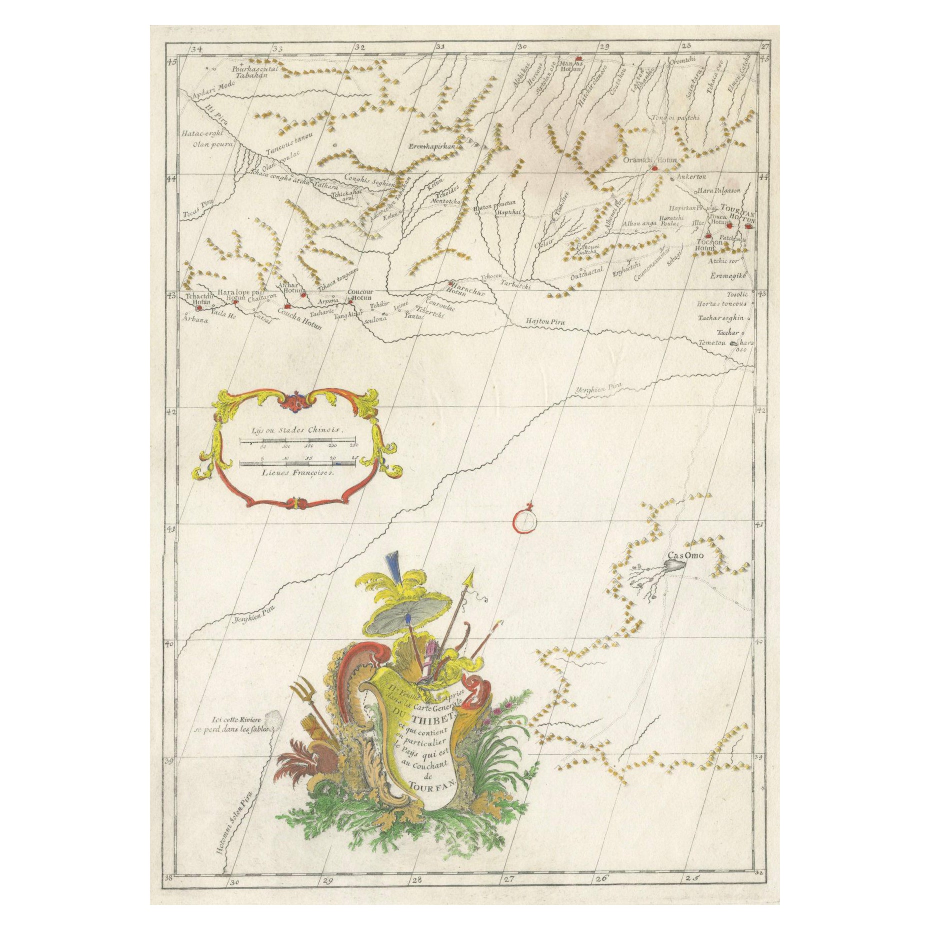
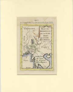
View AllAntique Map of Tibet and Region West of Turfan by D’Anville, Paris, 1737
Located in Langweer, NL
Antique Map of Tibet and Region West of Turfan by D’Anville, Paris, 1737
This finely engraved map is one of the detailed sheets from Jean-Baptiste Bourguignon d’Anville’s Carte géné...
Category
Antique 1730s French Maps
Materials
Paper
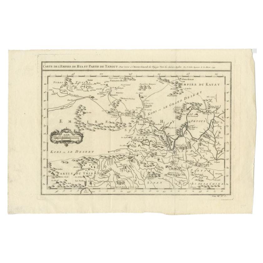
Antique Map of Tibet, The Gobi Desert and China by Bellin, circa 1764
Located in Langweer, NL
Antique map titled 'Carte de l'Empire de Hya et Partie de Tangut'. Old map of Tibet, Gobi desert and China depicting the Great Wall of China and caravan routes. Originates from Prevo...
Category
Antique 18th Century French Maps
Materials
Paper
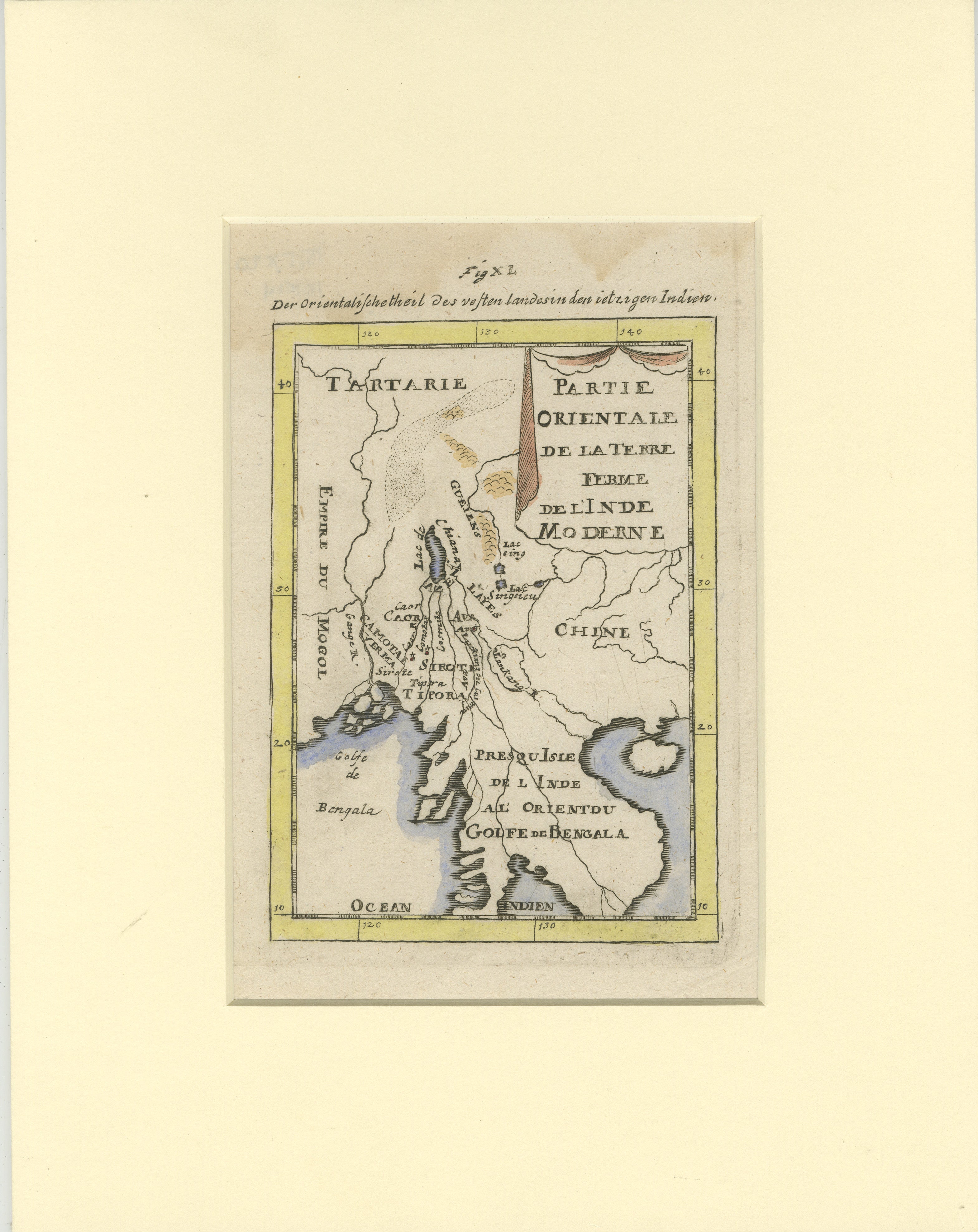
Antique Map of Northern India and the Bengal Gulf by Mallet, 1686
Located in Langweer, NL
This is a fine example of 17th or early 18th-century cartography, showcasing Southeast Asia, including parts of India, China, and the Gulf of Bengal. The French-labeled map highlights early European understanding of the Orient during the Age of Exploration.
Mounted in a soft cream matting board, the presentation enhances the map’s historical appeal while protecting its delicate condition.
The map features detailed geographical elements such as rivers, coastal lines, and mountain ranges. Regions like Tartarie, the Presqu'Isle de l'Inde, and the Golfe de Bengala are illustrated with early cartographic precision. Subtle hand-coloring highlights borders and coastal areas, adding to its visual charm.
In terms of condition, the map is well-preserved with clean paper with some waterdamage in the top, light toning, intact margins, and no visible tears or damage. The hand-coloring remains vibrant, reflecting careful handling over centuries.
This map provides insight into the evolving European knowledge of Asia and would make a distinguished addition to any collection of antique maps or historical artifacts.
Antique map titled "Partie Orientale de la Terre Ferme de l'Inde Moderne". Original antique map of the northern part of India and the Bengal Gulf. This map originates from Alain Manesson Mallet's 'Description de l 'Univers'. Artists and Engravers: Alain Manesson Mallet (1630?1706) was a French cartographer and engineer. He started his career as a soldier in the army of Louis XIV, became a Sergeant-Major in the artillery and an Inspector of Fortifications. He also served under the King of Portugal, before returning to France, and his appointment to the court of Louis XIV. His military engineering and mathematical background led to his position teaching mathematics at court. His major publications were Description de L'Univers (1683) in 5 volumes, and Les Travaux de Mars ou l'Art de la Guerre (1684) in 3 volumes. His Description de L'Universe contains a wide variety of information, including star maps...
Category
Antique 17th Century Maps
Materials
Paper
Antique Map of Tartary and Northeast Asia by Bellin, circa 1750
By Jacques-Nicolas Bellin
Located in Langweer, NL
Antique map titled 'Carte de la Tartarie Occidentale'. Map of Tartary and northeast Asia, from Lake Baykal, Partie du Siberia in the north, Pays des Kalkas at the center, as well as ...
Category
Antique Mid-18th Century European Maps
Materials
Paper

Antique Map of Northern China and Far Eastern Russia Around the Amur River, 1754
Located in Langweer, NL
Antique map titled 'Carte De La Tartarie Orientale (..)'. A map for this far eastern portion of what is present day northern China and far eastern Russia...
Category
Antique 1750s Maps
Materials
Paper

Antique Map of Western Tartary and the Gobi Desert of the Russian Empire, c.1750
Located in Langweer, NL
Antique map titled 'A Map of Western Tartary Drawn from the Survey of the Jesuits and Mr. Kyrillow's Map of the Russian Empire'. Map of the Gobi Desert and the eastern portion of the...
Category
Antique 18th Century Maps
Materials
Paper

You May Also Like
Antique French Map of Asia Including China Indoneseia India, 1783
Located in Amsterdam, Noord Holland
Very nice map of Asia. 1783 Dedie au Roy.
Additional information:
Country of Manufacturing: Europe
Period: 18th century Qing (1661 - 1912)
Condition: Overall Condition B (Good Used)...
Category
Antique 18th Century European Maps
Materials
Paper

$486 Sale Price
40% Off
Super Rare Antique French Map of Chine and the Chinese Empire, 1780
Located in Amsterdam, Noord Holland
Super Rare Antique French Map of Chine and the Chinese Empire, 1780
Very nice map of Asia. 1780 Made by Bonne.
Additional information:
Type: Map
...
Category
Antique 18th Century European Maps
Materials
Paper

$438 Sale Price
49% Off
California: 18th Century Hand-colored Map by de Vaugondy
By Didier Robert de Vaugondy
Located in Alamo, CA
This is an 18th century hand-colored map of the western portions of North America entitled "Carte de la Californie et des Pays Nord-Ouest separés de l'Asie par le détroit d'Anian, ex...
Category
1770s Landscape Prints
Materials
Engraving

$700 Sale Price
20% Off
California, Alaska and Mexico: 18th Century Hand-Colored Map by de Vaugondy
By Didier Robert de Vaugondy
Located in Alamo, CA
This is an 18th century hand-colored map of the western portions of North America entitled "Carte de la Californie et des Pays Nord-Ouest separés de l'Asie par le détroit d'Anian, ex...
Category
Antique 1770s French Maps
Materials
Paper

Siberia as Explored by Behring: Original 18th Century Hand-colored Map by Bowen
Located in Alamo, CA
This is an original 18th century hand-colored map entitled "An Exact Chart of all the Countries through which Capt. Behring Travelled from Tobolski, Capital of Siberia to the Country...
Category
Mid-18th Century Old Masters Landscape Prints
Materials
Engraving

1714 Henri Chatelain "Nouvelle Carte Des Etatas Du Grand.Duc De Mos Moscovie Eur
Located in Norton, MA
A 1714 Henri Chatelain map, entitled
"Nouvelle Carte Des Etatas Du Grand Duc De Moscovie En Europe,"
Ricb001
Henri Abraham Chatelain (1684-1743) was a Huguenot pastor of Parisi...
Category
Antique Early 18th Century Dutch Maps
Materials
Paper
