Items Similar to Antique Map of Turkey in Europe, Greece and the Balkans – Black’s Atlas, 1884

Want more images or videos?
Request additional images or videos from the seller
1 of 9
Antique Map of Turkey in Europe, Greece and the Balkans – Black’s Atlas, 1884
$462.76
£345.47
€390
CA$642.91
A$691.54
CHF 369.58
MX$8,151.30
NOK 4,659.53
SEK 4,259.70
DKK 2,972.24
About the Item
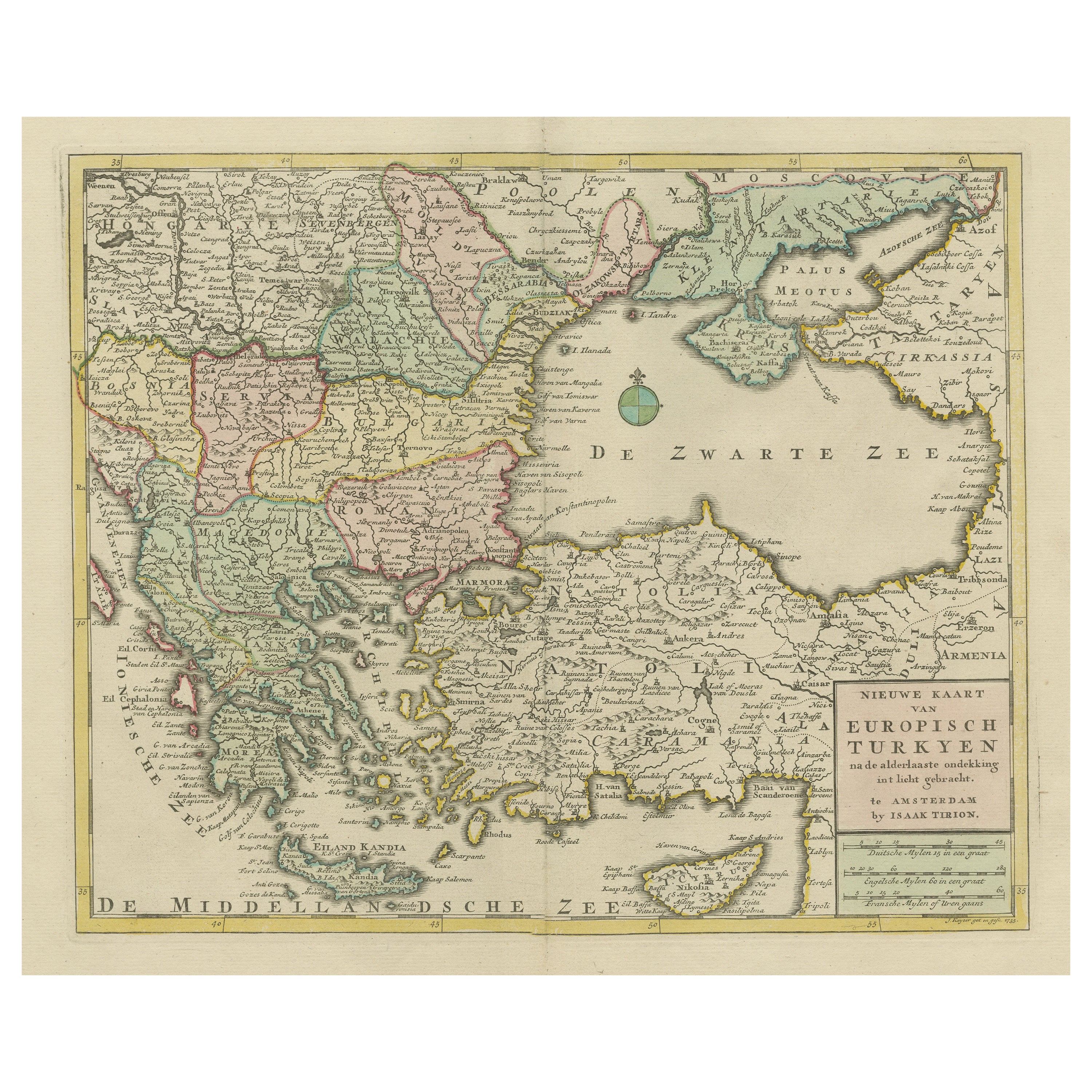
Antique Map of Turkey in Europe, Greece and the Balkans – Black’s Atlas, 1884
Description:
This finely engraved and hand-colored political map, titled “Turkey in Europe, Greece, Roumania, Servia, Montenegro &c.,” was published in the New and Revised Edition of Black’s General Atlas of the World, Edinburgh, 1884. It offers a detailed view of the Balkan Peninsula during a period of profound political transition in southeastern Europe.
The map covers a wide region stretching from the Adriatic Sea to the Black Sea and from the Austro-Hungarian Empire southward to Greece and Crete. It clearly delineates the territories of the Ottoman Empire in Europe alongside the emerging nation-states of Greece, Serbia, Montenegro, Roumania, and Bulgaria. Each region is distinguished by subtle original hand coloring, making political boundaries immediately legible while preserving the elegance of the engraving.
Major cities such as Constantinople (Istanbul), Athens, Sofia, Belgrade, Bucharest, and Salonika are prominently marked, along with an extensive network of towns, rivers, mountain ranges, and coastal features. Seas and gulfs including the Adriatic, Ionian, Aegean, and Black Seas are carefully labeled, underscoring the region’s strategic maritime importance.
This map reflects the shifting balance of power in the Balkans following the decline of Ottoman control and the rise of national independence movements during the late 19th century. As such, it is not only a geographic document but also a vivid historical snapshot of a complex and contested region on the eve of modern political realignment.
Condition report:
Very good condition. Original hand coloring remains clear and attractive. Center fold as issued. Light toning and faint age-related spotting to margins, consistent with atlas maps of this period. Plate mark visible. No tears or losses.
Framing tips:
This map displays beautifully with an archival mat in ivory or light cream to complement the soft pastel coloring. A dark walnut or black frame enhances contrast and legibility, while a gilt frame emphasizes its late Victorian character. UV-protective glass is recommended to preserve the original colors.
Technique: Engraving with original hand coloring
Maker: Black’s General Atlas, Edinburgh, 1884
- Dimensions:Height: 24.1 in (61.2 cm)Width: 17.84 in (45.3 cm)Depth: 0.01 in (0.2 mm)
- Materials and Techniques:
- Place of Origin:
- Period:
- Date of Manufacture:1884
- Condition:Very good condition. Original hand coloring remains clear and attractive. Center fold as issued. Light toning and faint age-related spotting to margins, consistent with atlas maps of this period. Plate mark visible. No tears or losses.
- Seller Location:Langweer, NL
- Reference Number:Seller: BG-13601-3-191stDibs: LU3054348279432
About the Seller
5.0
Recognized Seller
These prestigious sellers are industry leaders and represent the highest echelon for item quality and design.
Platinum Seller
Premium sellers with a 4.7+ rating and 24-hour response times
Established in 2009
1stDibs seller since 2017
2,836 sales on 1stDibs
Typical response time: 1 hour
- ShippingRetrieving quote...Shipping from: Langweer, Netherlands
- Return Policy
More From This Seller
View AllBalkans
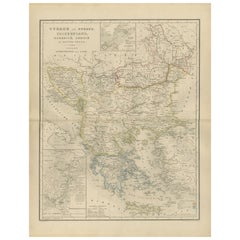
Ottoman Europe Map with Athens Inset – Nieuwe Hand-Atlas, 1876
Located in Langweer, NL
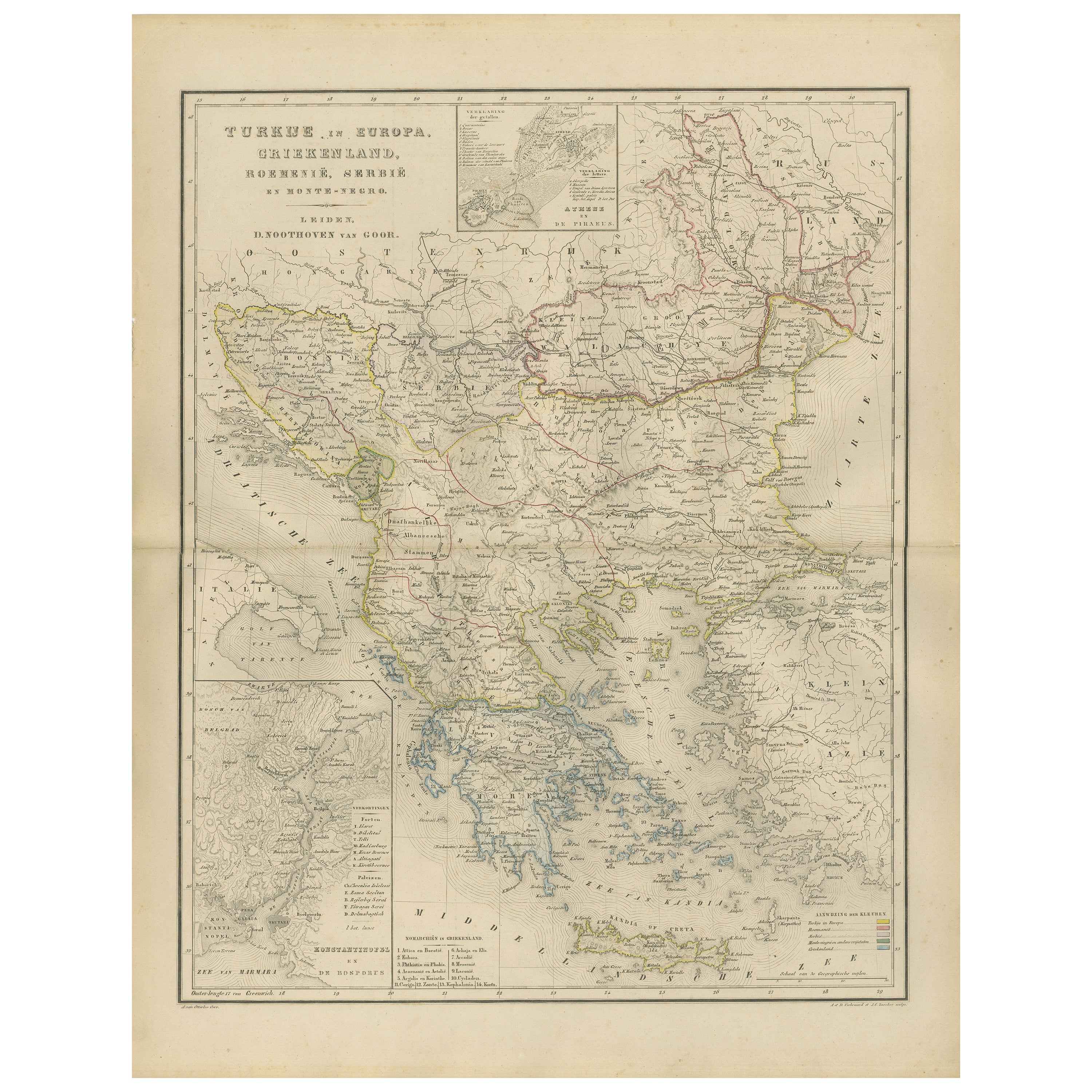
Balkans & Ottoman Europe Map with Athens Inset – Nieuwe Hand-Atlas, 1876
This impressive 19th-century map titled “Turkije in Europa, Griekenland, Roemenië, Servië en Montenegro” provides a richly detailed view of the Balkan Peninsula and the remaining European territories of the Ottoman Empire during a critical historical moment. Published in 1876 in the Nieuwe Hand-Atlas der Aarde in haren Tegenwoordigen Toestand by M. Frijlink, revised by A. van Otterloo and printed by D. Noothoven van Goor in Leiden, this map captures the political and geographical landscape of the Balkans just before the Russo-Turkish War (1877–78) and the subsequent Treaty of Berlin reshaped the region.
The map spans from the Adriatic Sea to the Black Sea, and from the Danube valley down to Crete, covering modern-day Greece, Albania, North Macedonia, Bulgaria, Romania, Serbia, Montenegro, Bosnia and Herzegovina, Thrace, European Turkey, and the Aegean Islands. Hand-colored boundary lines clearly distinguish political units including the Kingdom of Greece, the Principality of Serbia, the United Principalities of Wallachia and Moldavia (Romania), and Ottoman provinces such as Rumelia, Thessaly, Epirus, and Macedonia.
Major cities—Constantinople (Istanbul), Athens, Bucharest, Belgrade, Sofia, Salonika (Thessaloniki), Skodra, Ioannina, Larissa, Adrianople (Edirne), Varna, and Trabzon—are identified with fine engraving work. The map also reflects the complex geography of the region, showing mountain chains such as the Balkans, Pindus, Rhodope, and Dinaric Alps, as well as large river systems including the Danube, Morava, Drina, Vardar, Maritsa, and Iskar.
Inset maps provide valuable additional context: one illustrates the Bosphorus and surrounding fortifications, another focuses on Athens and Piraeus, and a third presents the region around the Gulf of Salonika and Northern Greece. These allow a closer look at strategic locations central to 19th-century European geopolitics.
This plate captures the Balkans at a moment of transition, when national movements were rising and the Ottoman Empire was gradually losing influence. The elegant engraving, refined typography, and harmonious composition are characteristic of Dutch educational cartography at its peak. Today, the map serves as a historical snapshot of a region defined by shifting borders, cultural layers, and emerging nation-states.
Condition Report:
Good condition with gentle toning and scattered small foxing marks, mostly in the margins. Original center fold as issued. Image clean and well-printed with soft, even hand-coloring. No tears, losses, or repairs.
Framing Tips: A light ivory or cream mat works beautifully to highlight the delicate color washes. A slim dark wood or black frame adds contrast and sophistication. Because the map includes attractive insets, a slightly wider mat border enhances balance and readability. Suitable for libraries, studies, travel-themed interiors, and collectors of Ottoman, Greek, and Balkan cartography.
Keywords: Balkans, Ottoman Empire, Turkey in Europe, European Turkey, Greece, Athens, Piraeus, Macedonia, Thrace, Epirus, Thessaly, Crete, Aegean Sea, Bulgaria, Sofia, Varna, Plovdiv, Romania, Bucharest, Wallachia, Moldavia, Danube, Serbia, Belgrade, Montenegro, Cetinje, Albania, Skodra, Ioannina, Thessaloniki, Salonika, Constantinople, Istanbul, Bosphorus, Dardanelles, Adriatic Sea, Aegean Islands, Balkan Peninsula, 19th century Balkans map, 1876 Ottoman map...
Category
Antique 1870s Dutch Maps
Materials
Paper
Small Antique Map of the European Turkey, Greece
Ionian Islands – c.1860
Located in Langweer, NL
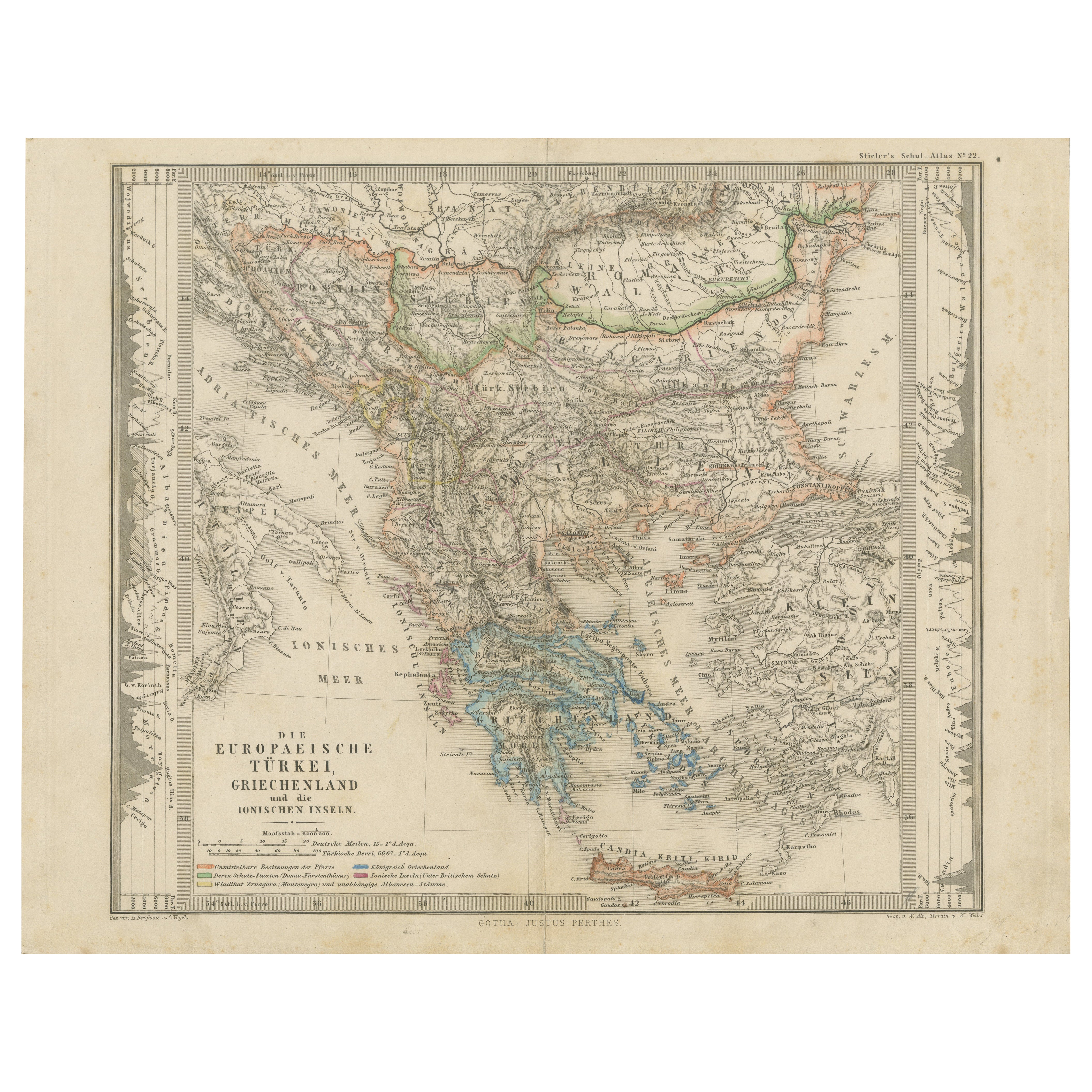
Antique Map of the European Turkey, Greece & Ionian Islands – Stieler, c.1860
Original antique map titled *Die Europaeische Türkei, Griechenland und die ...
Category
Antique 1860s Maps
Materials
Paper

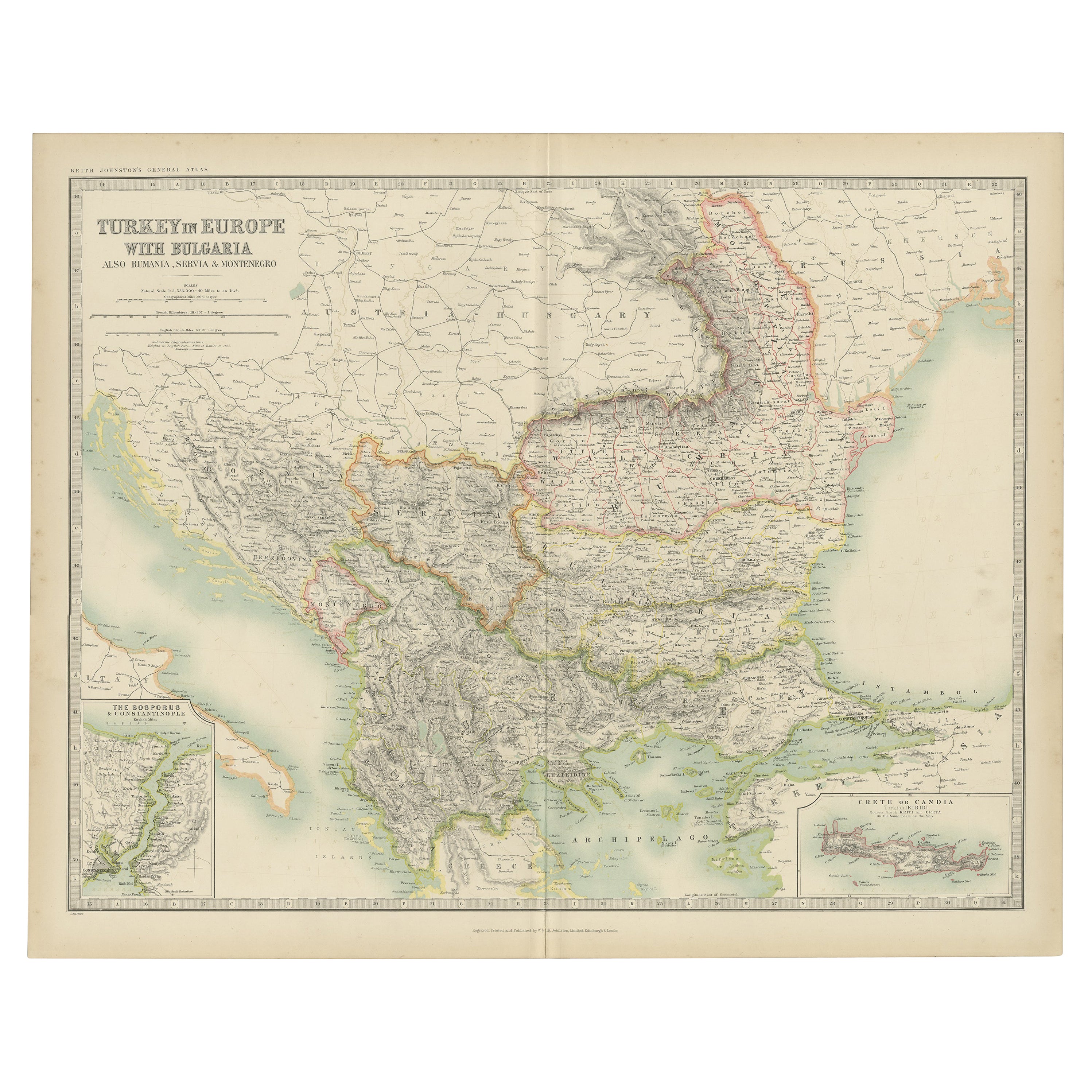
Antique Map of Turkey in Europe with Bulgaria by Johnston, 1909
Located in Langweer, NL
Antique map titled 'Turkey in Europe with Bulgaria'. Original antique map of Turkey in Europe with Bulgaria. With inset maps of The Bosporus & Constantinople, and Crete (or Candia). ...
Category
Early 20th Century American Maps
Materials
Paper
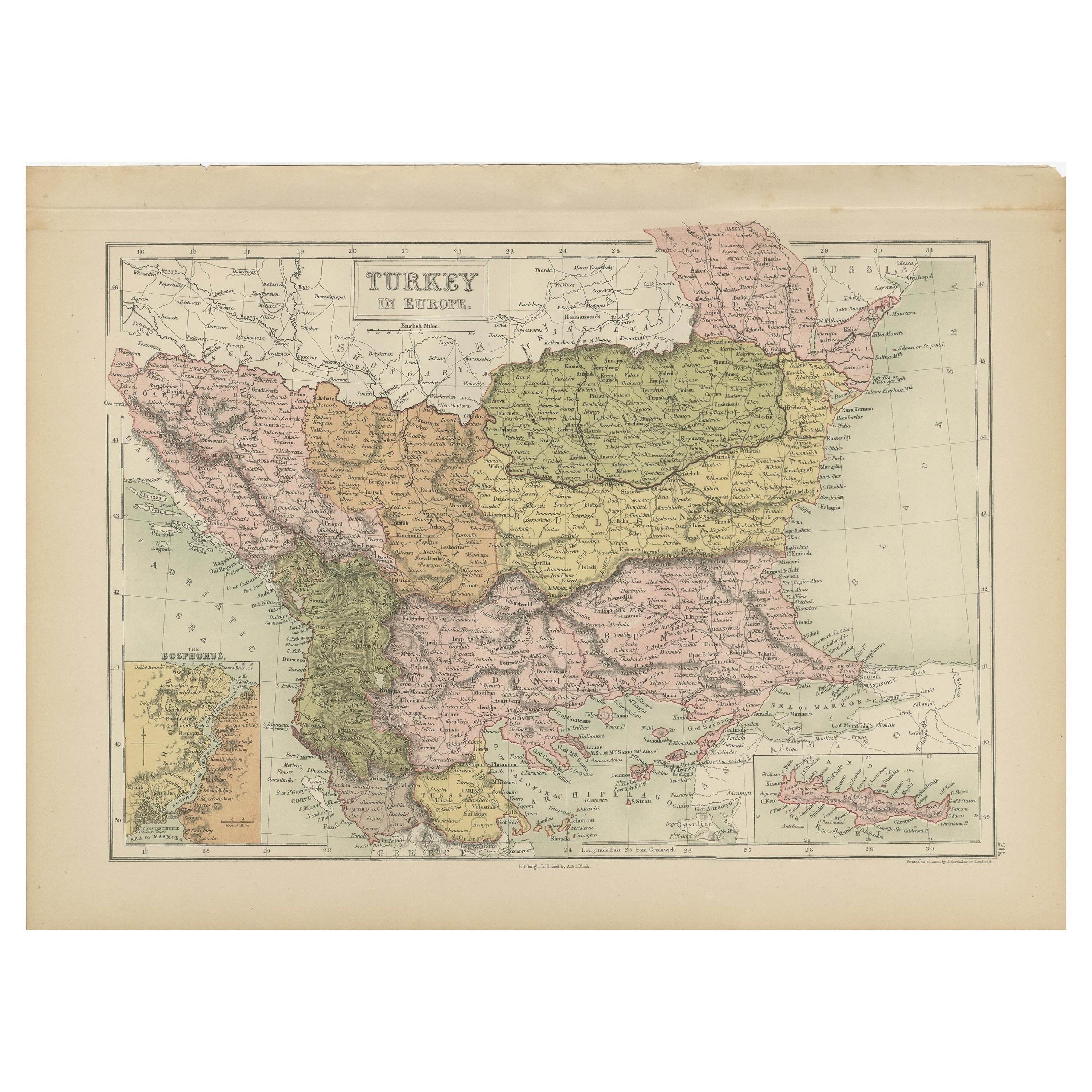
Antique Map of Turkey in Europe by A
C. Black, 1870
Located in Langweer, NL
Antique map titled 'Turkey in Europe'. Original antique map of Turkey in Europe with inset maps of the Bosporus and Crete or Candia. This map originates from ‘Black's General Atlas o...
Category
Antique Late 19th Century Maps
Materials
Paper
$166 Sale Price
20% Off
Antique Map of Greece, Turkey and surroundings with original coloring
Located in Langweer, NL
Antique map titled 'Nieuwe Kaart van Europisch Turkyen na de alderlaatste ontdekking in t licht gebracht'. Antique map of Greece with Crete and Cyprus, Turkey and the Black Sea. Publ...
Category
Antique Mid-18th Century Maps
Materials
Paper

$654 Sale Price
20% Off
Antique Map of Turkey and Greece by Petri, c.1873
Located in Langweer, NL
Antique map titled 'Europisch Turkije en Griekenland'. Old map depicting Turkey in Europe and Greece. This map originates from 'School-Atlas van alle Deelen der Aarde'.
Artists and...
Category
Antique 19th Century Maps
Materials
Paper

You May Also Like
Hand-Colored 18th Century Homann Map of the Danube, Italy, Greece, Croatia
By Johann Baptist Homann
Located in Alamo, CA
"Fluviorum in Europa principis Danubii" is a hand colored map of the region about the Danube river created by Johann Baptist Homann (1663-1724) in his 'Atlas Novus Terrarum', publish...
Category
Antique Early 18th Century German Maps
Materials
Paper

Map of Ancient Greece of Macedonia and... - Lithograph by Auguste Wahlen - 1844
Located in Roma, IT
Map of Ancient Greece of Macedonia and Thrace is a lithograph made by Auguste Wahlen in 1844.
Hand colored.
Good condition.
Bottom left is the original title "Carta della Grecia A...
Category
1840s Modern Figurative Prints
Materials
Lithograph

Map of Eastern Roman Empire -Vintage Offset Print - Early 20th Century
Located in Roma, IT
This map of Eastern Roman Empire is a vintage offset print realized in the early 20th Century.
The state of preservation of the artwork is aged with dif...
Category
Early 20th Century Figurative Prints
Materials
Offset

Large Original Antique Map of Cyprus. 1894
Located in St Annes, Lancashire
Superb Antique map of Cyprus
Published Edward Stanford, Charing Cross, London 1894
Original colour
Good condition
Unframed.
Free shipping
Category
Antique 1890s English Maps
Materials
Paper

Map of Greece - Etching on Paper 19th Century
Located in Roma, IT
Image dimensions: 22.2 x 27.8 cm.
Grecia is an interesting hand-colored etching on paper, realized by an anonymous artist in the first half of the XIX century.
With the inscriptions in Italian, this original print describes the geography of Greece with the great charisma of the antique maps.
In very good conditions, except for a usual yellowing of the paper at the edges and minor defects and signs of the time, and some light yellow strips...
Category
19th Century Modern Figurative Prints
Materials
Etching

Russia in Europe with Poland and Finland. Century Atlas antique vintage map
Located in Melbourne, Victoria
'The Century Atlas. Russia in Europe with Poland and Finland'
Original antique map, 1903.
Central fold as issued. Map name and number printed on the reverse corners.
Sheet 40cm by ...
Category
Early 20th Century Victorian More Prints
Materials
Lithograph
