Items Similar to Antique Map of the United States with Vignette of Washington


Want more images or videos?
Request additional images or videos from the seller
1 of 6
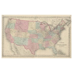
Antique Map of the United States with Vignette of Washington
$456.48
$570.6020% Off
£339.75
£424.6920% Off
€384
€48020% Off
CA$633.09
CA$791.3620% Off
A$681.58
A$851.9720% Off
CHF 365
CHF 456.2520% Off
MX$8,212.75
MX$10,265.9320% Off
NOK 4,605.25
NOK 5,756.5720% Off
SEK 4,214.55
SEK 5,268.1920% Off
DKK 2,926.79
DKK 3,658.4920% Off
About the Item
Antique map titled 'États-Unis'. A very attractive and detailed late 19th century map of the United States, with a fine decorative vignette of Washington. The extensive railway network which had been established in United States by that time is clearly illustrated.
Published by J. Migeon, circa 1875. J. Migeon was a late 19th century map publisher based in Paris, France.
- Dimensions:Height: 15.44 in (39.2 cm)Width: 20.4 in (51.8 cm)Depth: 0.02 in (0.5 mm)
- Materials and Techniques:
- Period:
- Date of Manufacture:circa 1875
- Condition:Wear consistent with age and use. Age-related toning, original folding line. Shows some wear and soiling, blank verso. Please study images carefully.
- Seller Location:Langweer, NL
- Reference Number:Seller: BG-13192-51stDibs: LU3054331369962
About the Seller
5.0
Recognized Seller
These prestigious sellers are industry leaders and represent the highest echelon for item quality and design.
Platinum Seller
Premium sellers with a 4.7+ rating and 24-hour response times
Established in 2009
1stDibs seller since 2017
2,828 sales on 1stDibs
Typical response time: 1 hour
- ShippingRetrieving quote...Shipping from: Langweer, Netherlands
- Return Policy
More From This Seller
View AllAntique Map Colton
s United States of America
Located in Langweer, NL
Antique map titled 'Colton's United States of America'. Show railroads, canals, state capitals, major cities and towns, military posts, historic trails, Pony Express and U.S. mail routes; Dakota [Territory] extending deep into Nebraska, and Idaho [Territory] encompassing [modern day] Montana and Wyoming; Indian Territory...
Category
Antique Mid-19th Century Maps
Materials
Paper
$846 Sale Price
20% Off
Antique Map of the United States by Titus
1871
Located in Langweer, NL
Antique map titled 'The United States of America'. Original antique map of the United States. This map originates from 'Atlas of Prebl...
Category
Antique Late 19th Century Maps
Materials
Paper

$760 Sale Price
20% Off
Antique Map of the United States of North America, c.1882
Located in Langweer, NL
Antique map titled 'United States of North America'. Old map of the United States of North America. This map originates from 'The Royal Atlas of Modern Geography, Exhibiting, in a Se...
Category
Antique 1880s Maps
Materials
Paper

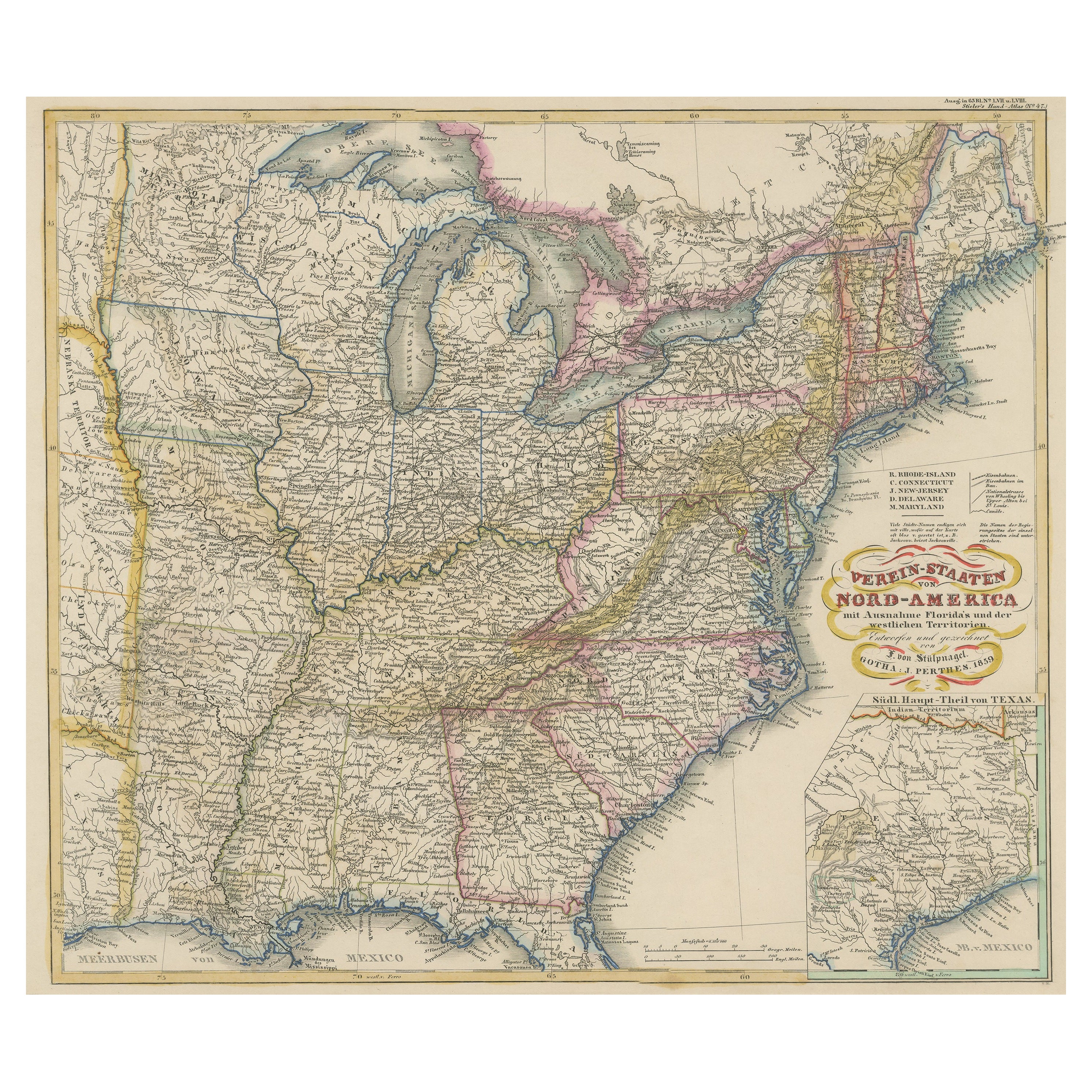
Antique Map of the Eastern United States with Inset Map of Texas
Located in Langweer, NL
Antique map titled 'Verein-Staaten von Nord-America mit Ausnahme Florida's und der Westlichen Territorien'. This map extends as far west as Louisiana and only includes the northern p...
Category
Antique Mid-19th Century Maps
Materials
Paper

$513 Sale Price
20% Off
Antique Map of The United States of North America, 1882
Located in Langweer, NL
This is a historical map titled "The United States of North America, Central Part" from the 1882 Blackie Atlas. It depicts the continental United States with a high level of detail, ...
Category
Antique 1880s British Maps
Materials
Paper

$237 Sale Price
20% Off
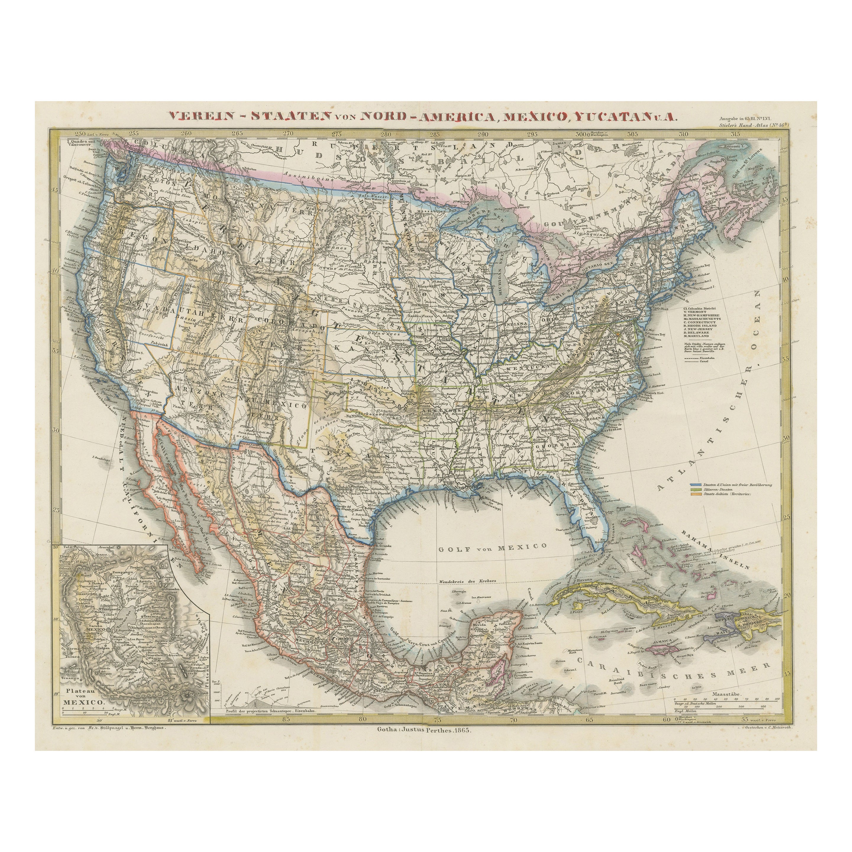
Antique Map of the United States of America, also showing the Caribbean
Located in Langweer, NL
Antique map titled 'Verein-Staaten von Nord-America, Mexico, Yucatan u.a.'. Very detailed map of the United States of America showing the ...
Category
Antique Mid-19th Century Maps
Materials
Paper

$779 Sale Price
20% Off
You May Also Like
Original Antique Map of United States, Grattan and Gilbert, 1843
Located in St Annes, Lancashire
Great map of United States
Drawn and engraved by Archer
Published by Grattan and Gilbert. 1843
Original colour
Unframed.
Category
Antique 1840s English Maps
Materials
Paper

Large Original Antique Map of the United States of America. 1891
By Rand McNally
Co.
Located in St Annes, Lancashire
Fabulous map of The United States
Original color
By Rand, McNally & Co.
Dated 1891
Unframed
Free shipping.
Category
Antique 1890s American Maps
Materials
Paper

Original Antique Map of The United States of America by Dower, circa 1835
Located in St Annes, Lancashire
Nice map of the USA
Drawn and engraved by J.Dower
Published by Orr & Smith. C.1835
Unframed.
Free shipping
Category
Antique 1830s English Maps
Materials
Paper

1866 "Johnson
s United States" Map, Published by Johnson and Ward
Located in Colorado Springs, CO
Presented is a detailed map of the United States by A. J. Johnson. Spanning the whole of the continental United States, as well as adjacent parts of Canada and Mexico, the map reflec...
Category
Antique 1860s American Victorian Maps
Materials
Paper

1856 "Map of the United States" by Ensign, Bridgeman, and Fanning
Located in Colorado Springs, CO
Presented is a scarce American wall map of the United States and Mexico issued by Ensign, Bridgman, and Fanning in 1856. As the title suggests, the map covers all of the United State...
Category
Antique 1850s American Victorian Maps
Materials
Paper

Large Original Vintage Map of North America, circa 1920
Located in St Annes, Lancashire
Great map of North America
Original color. Good condition
Published by Alexander Gross
Unframed.
Category
Vintage 1920s English Edwardian Maps
Materials
Paper
