Items Similar to Antique Map of Victoria, or Port Phillip in Australia, ca. 1850


Want more images or videos?
Request additional images or videos from the seller
1 of 7
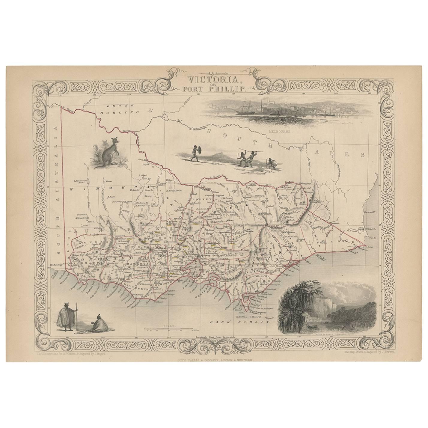
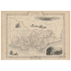
Antique Map of Victoria, or Port Phillip in Australia, ca. 1850
$680
$85020% Off
£518.70
£648.3720% Off
€590.95
€738.6920% Off
CA$955.75
CA$1,194.6820% Off
A$1,042.69
A$1,303.3720% Off
CHF 552.10
CHF 690.1320% Off
MX$12,494.44
MX$15,618.0520% Off
NOK 7,031.30
NOK 8,789.1320% Off
SEK 6,429.60
SEK 8,03720% Off
DKK 4,412.54
DKK 5,515.6820% Off
About the Item
This antique map, measuring approximately 12.7 x 10.0 inches, showcases Victoria, specifically centered around Melbourne, Australia. Crafted by John Tallis around 1850, this map is part of the Illustrated Atlas and Modern History of the World.
Noteworthy for its superb detailing, the map features vignettes highlighting the cultural and natural essence of the region. It includes depictions of Aborigines, a kangaroo, and a striking view of Melbourne across the water. The latter portrays a bustling scene with a sailing ship and two early steamships navigating the foreground.
Offering historical and geographical insights, this map serves as a valuable artifact, portraying the landscape and cultural elements of Victoria during the mid-19th century. It's available for purchase, providing a chance to own a piece of history with worldwide free shipping.
- Dimensions:Height: 10 in (25.4 cm)Width: 12.7 in (32.26 cm)Depth: 0.002 in (0.06 mm)
- Materials and Techniques:
- Place of Origin:
- Period:
- Date of Manufacture:1850
- Condition:Very good condition. Minor soiling due to age and handling. Study image carefully.
- Seller Location:Langweer, NL
- Reference Number:Seller: BG-13069-21stDibs: LU3054325866062
About the Seller
5.0
Recognized Seller
These prestigious sellers are industry leaders and represent the highest echelon for item quality and design.
Platinum Seller
Premium sellers with a 4.7+ rating and 24-hour response times
Established in 2009
1stDibs seller since 2017
2,792 sales on 1stDibs
Typical response time: <1 hour
- ShippingRetrieving quote...Shipping from: Langweer, Netherlands
- Return Policy
More From This Seller
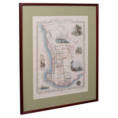
View AllAntique Map of Victoria ‘Australia’ by J. Tallis, circa 1855
Located in Langweer, NL
A highly decorative and finely engraved mid-19th century map of Victoria, Australia which appeared in John Tallis & co.'s The Illustrated Atlas (London...
Category
Antique Mid-19th Century British Maps
Materials
Paper
$287 Sale Price
20% Off
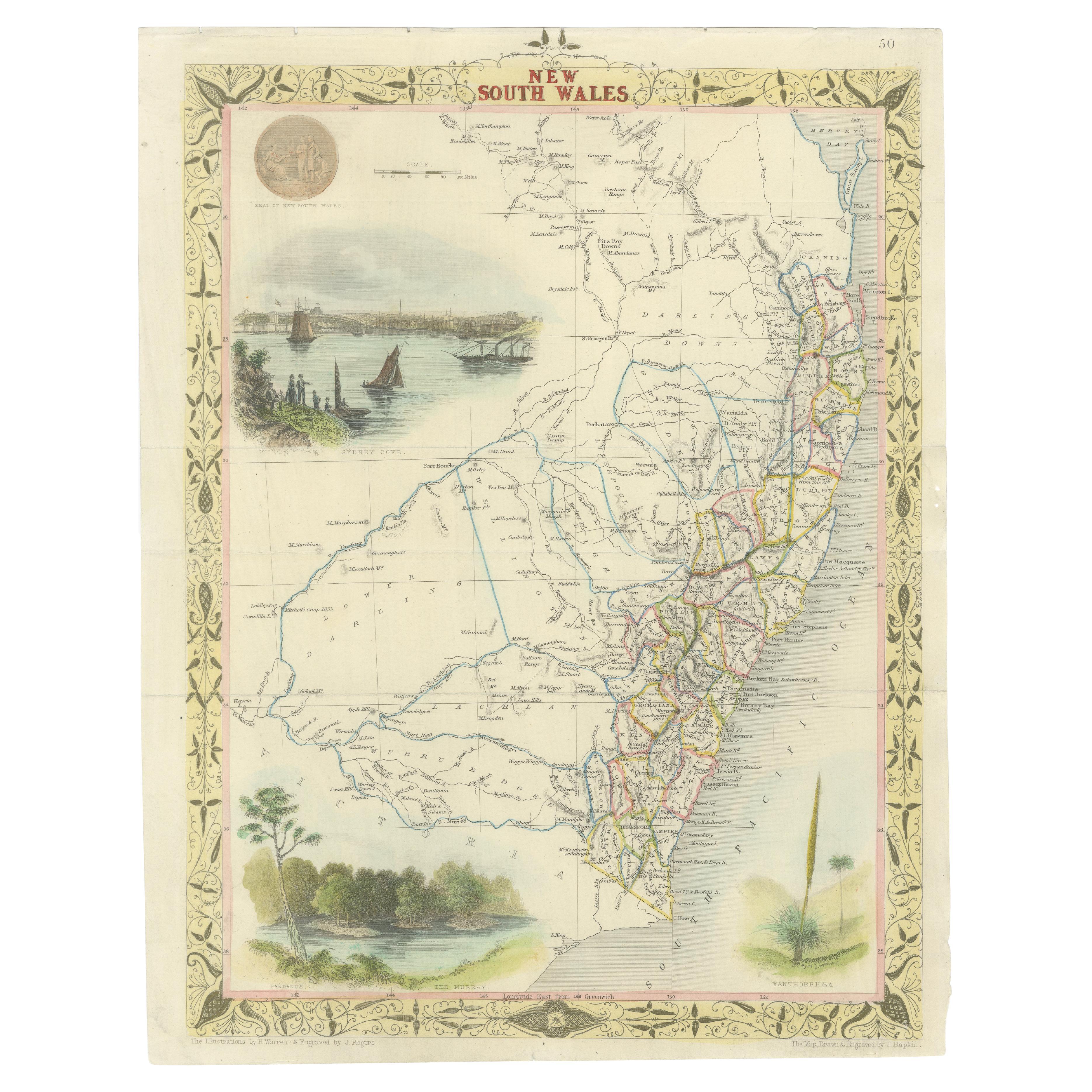
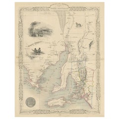
Antique Map of New South Wales in Australia, ca. 1850
Located in Langweer, NL
Antique map of Victoria, or Port Phillip (12.7 x 10.0") in Australia. Superb map of Victoria roughly centered on Melbourne. Vignettes of Aborigines, a ...
Category
Antique Mid-19th Century European Maps
Materials
Paper

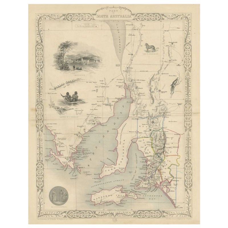
Antique Map of South Australia by Tallis, 1851
By Thomas Kitchin
Located in Langweer, NL
Antique map Australia titled 'Part of South Australia'. Decorative map of part of South Australia, surrounded by illustrations of Adelaide, natives on a catamaran, an Australian dog and a nymphicus bird illustrated. Originates from 'The Illustrated Atlas, And Modern History Of The World Geographical, Political, Commercial & Statistical, Edited By R. Montgomery Martin'. Published; John Tallis London, New York, Edinburgh & Dublin. 1851. Drawn and Engraved by J. Rapkin. Artists and Engravers: John Tallis (1817-1876) was a British map...
Category
Antique 19th Century Maps
Materials
Paper
$215 Sale Price
20% Off
Antique Map of Southeastern Australia by F. von Stülpnagel, 1850
Located in Langweer, NL
Antique map titled 'Süd-Östlichen Australien'. Map of southeastern Australia with inset maps of southwest Australia and Tasmania compiled by the military cartographer Friedrich von S...
Category
Antique Mid-19th Century Maps
Materials
Paper

$171 Sale Price
35% Off
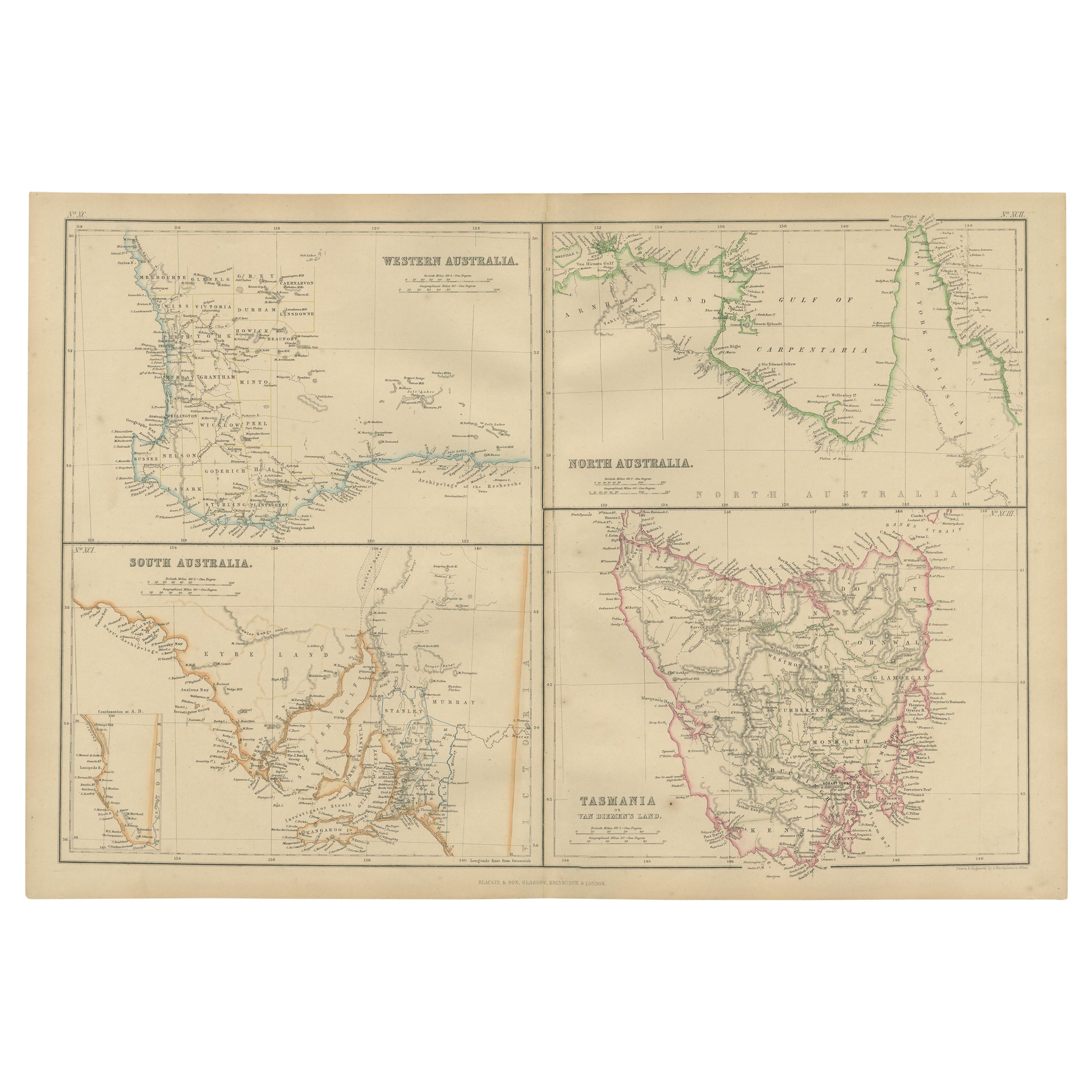
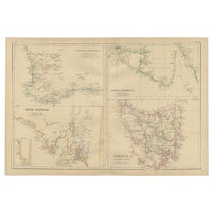
Antique Map of West, South, North Australia and Tasmania by W. G. Blackie, 1859
Located in Langweer, NL
Antique map titled 'Western Australia, South Australia, North Australia and Tasmania'. Original antique map of Western Australia, South Australia, North Australia and Tasmania. This ...
Category
Antique Mid-19th Century Maps
Materials
Paper
$239 Sale Price
20% Off
Antique Detailed Map of New South Wales, Queensland
Victoria, Australia, 1865
Located in Langweer, NL
Antique map Australia titled 'South Australia, New South Wales, Victoria & Queensland'. Old map depicting South Australia including New South Wal...
Category
Antique 19th Century Maps
Materials
Paper

$335 Sale Price
20% Off
You May Also Like
Original Antique Map of Australia by Dower, circa 1835
Located in St Annes, Lancashire
Nice map of Australia
Drawn and engraved by J.Dower
Published by Orr & Smith. C.1835
Unframed.
Free shipping
Category
Antique 1830s English Maps
Materials
Paper

Large Original Antique Map of Australia by Sidney Hall, 1847
Located in St Annes, Lancashire
Great map of Australia
Drawn and engraved by Sidney Hall
Steel engraving
Original colour outline
Published by A & C Black. 1847
Unframed
Free shipping.
Category
Antique 1840s Scottish Maps
Materials
Paper

Australia, Tallis antique map, 1851
Located in Melbourne, Victoria
'Australia'
With decorative border surrounds and vignettes including a view of Sydney, Kangaroos, Natives of Australia Felix, Australian Parrots and Cockatoos and Natives of the Tri...
Category
19th Century Naturalistic Landscape Prints
Materials
Engraving

New South Wales, Australia, antique mid 19th century engraved John Tallis map
Located in Melbourne, Victoria
'New South Wales'
With decorative border surrounds and vignettes of 'Sydney Cove'. 'The Murray' and 'Xanthorrhea'.
'Drawn and engraved by J Rapkin'. Published by John Tallis.
375m...
Category
1840s Victorian Landscape Prints
Materials
Engraving

Vintage Australia Map, Framed, Historic 19th Century Cartography Interest, 1988
Located in Hele, Devon, GB
This is a vintage Australia map. A late 20th century reproduction of John Tallis’ original 1850 steel engraving, produced to mark the 1988 Australian Bicentennial.
Fascinating repro...
Category
1990s Australian Victorian Maps
Materials
Glass, Paper

Vintage Western Australia Map, Framed Print, Swan River, John Tallis Cartography
Located in Hele, Devon, GB
This is a vintage Western Australia map. A late 20th century reproduction of John Tallis’ original 1850 steel engravings, dating to the late 20th century, circa 1990.
Fascinating re...
Category
1990s Australian Victorian Maps
Materials
Glass, Paper
More Ways To Browse
Australian Antique Furniture
19th Century Australian Furniture
Antique Kangaroo
Used Victoria Antique Furniture
Antique Texas Furniture
Military Map
Antique Maps New Zealand
Birds Eye View Map
North Africa Map
West Africa Map
Antique Compass Map
Antique Maps California
Biblical Maps
Hungary Map
Maps Of Mediterranean
Treasure Map
Antique Navigational Tools
Mississippi Furniture