Items Similar to Antique Map of West Africa by Lowry, 1852

Want more images or videos?
Request additional images or videos from the seller
1 of 9
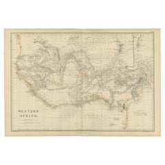
Antique Map of West Africa by Lowry, 1852
$298.13per set
£220.75per set
€250per set
CA$411.78per set
A$441.02per set
CHF 237.09per set
MX$5,356.42per set
NOK 2,995.72per set
SEK 2,742.81per set
DKK 1,905.32per set
About the Item
Antique map titled 'West Africa'. Three individual sheets of West Africa. This map originates from 'Lowry's table Atlas constructed and engraved from the most recent authorities' by J.W. Lowry. Published 1852.
- Dimensions:Height: 12.21 in (31 cm)Width: 9.65 in (24.5 cm)Depth: 0.02 in (0.5 mm)
- Sold As:Set of 3
- Materials and Techniques:
- Place of Origin:
- Period:
- Date of Manufacture:1852
- Condition:General age-related toning, blank verso. Minor wear, please study images carefully.
- Seller Location:Langweer, NL
- Reference Number:Seller: BG-12593-60, BG-12593-61 BG-12593-621stDibs: LU3054321550752
About the Seller
5.0
Recognized Seller
These prestigious sellers are industry leaders and represent the highest echelon for item quality and design.
Platinum Seller
Premium sellers with a 4.7+ rating and 24-hour response times
Established in 2009
1stDibs seller since 2017
2,826 sales on 1stDibs
Typical response time: 1 hour
- ShippingRetrieving quote...Shipping from: Langweer, Netherlands
- Return Policy
More From This Seller
View AllAntique Map of North Africa by Lowry
1852
Located in Langweer, NL
Antique map titled 'North Africa Marocco Algiers & Tunis'. Two individual sheets of North Africa. This map originates from 'Lowry's Table Atlas constructed and engraved from the most...
Category
Antique Mid-19th Century Maps
Materials
Paper

$143 Sale Price / set
20% Off
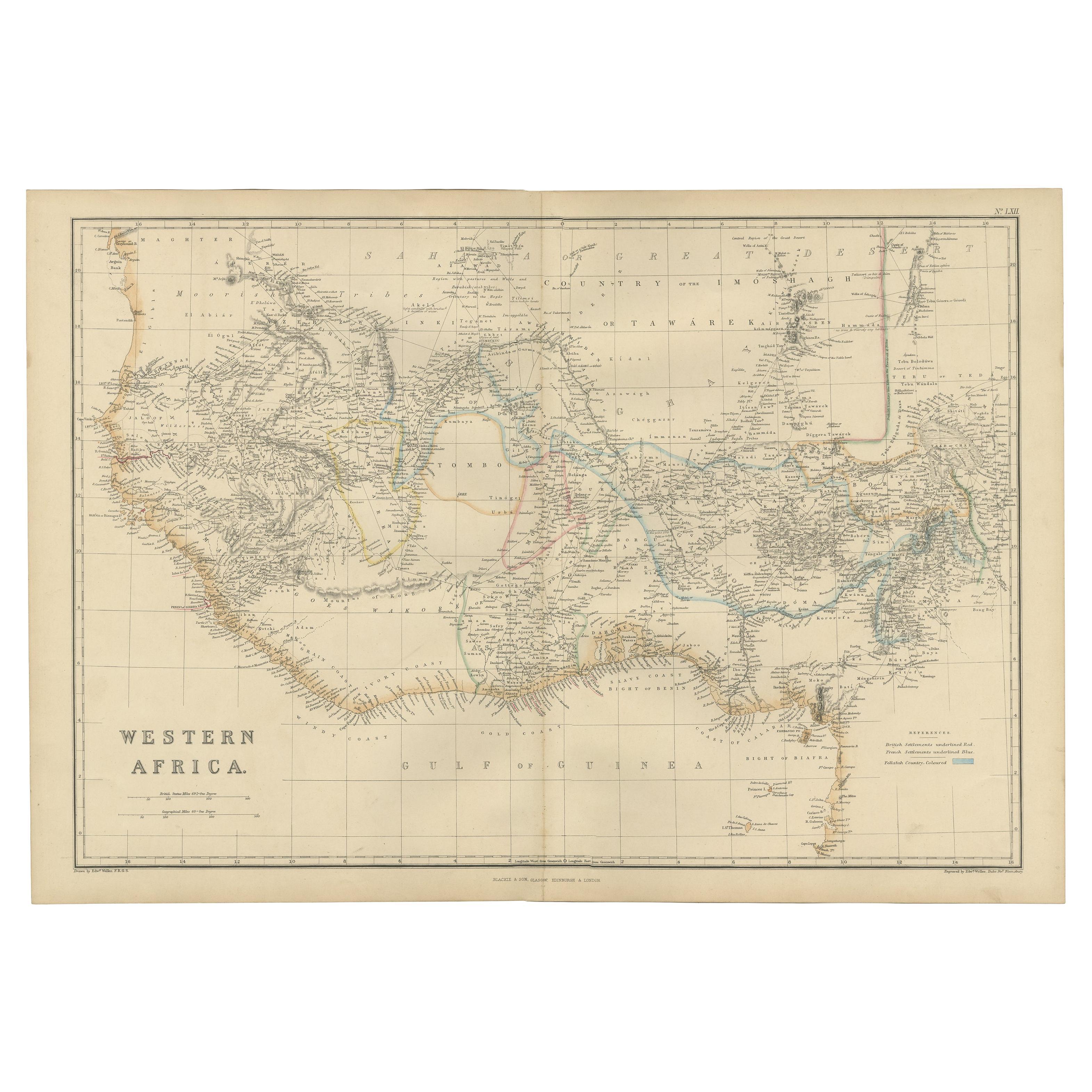
Western Africa Antique Map by W. G. Blackie, 1859
Located in Langweer, NL
The antique map titled 'Western Africa' presents an original depiction of the region. Originating from 'The Imperial Atlas of Modern Geography,' this map was published by W. G. Black...
Category
Antique Mid-19th Century Maps
Materials
Paper
$238 Sale Price
20% Off
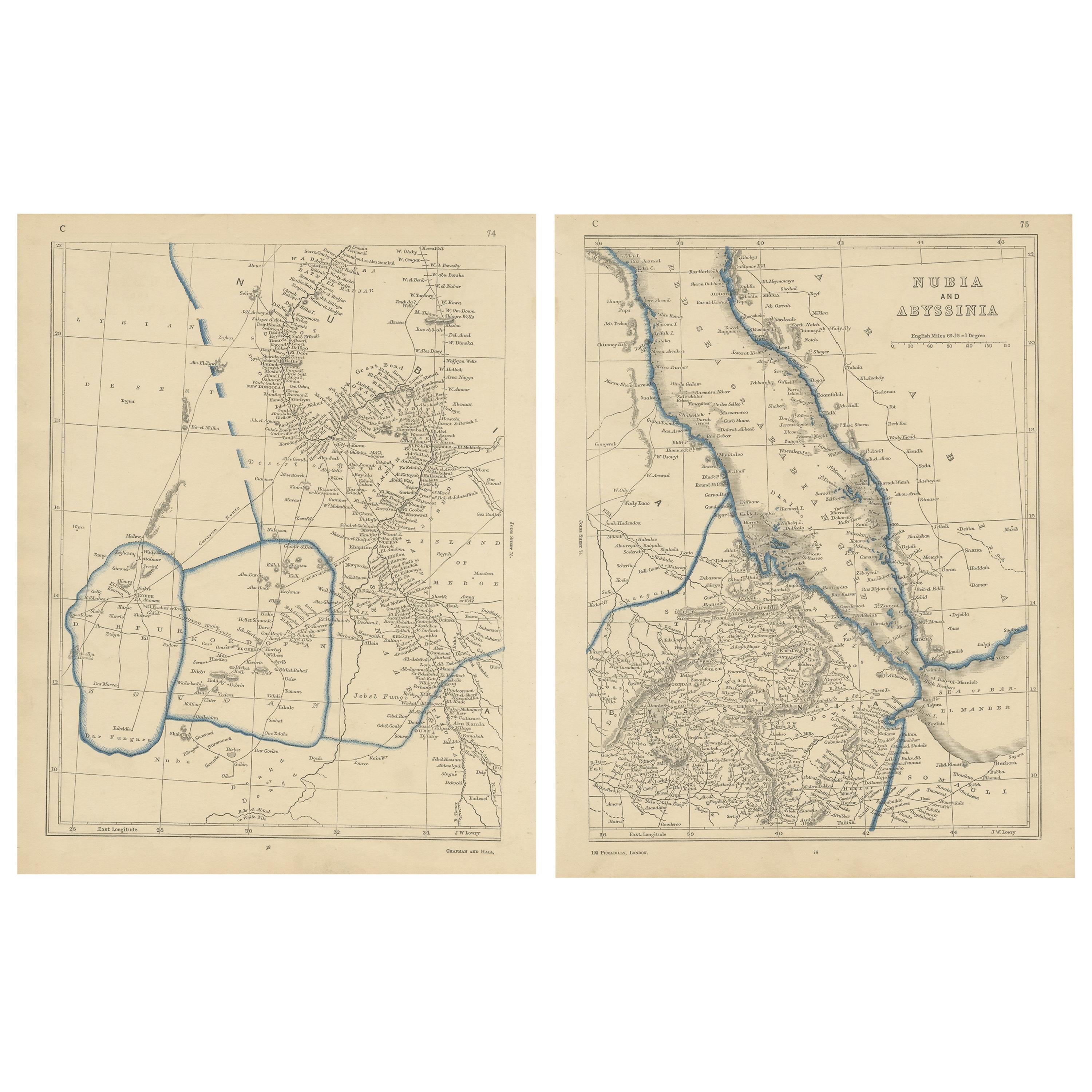
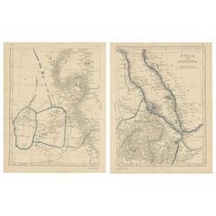
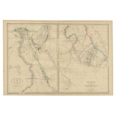
Antique Map of Nubia and Abyssina by Lowry, 1852
Located in Langweer, NL
Antique map titled 'Nubia and Abyssina'. Two individual sheets of Nubia and Abyssina. This map originates from 'Lowry's Table Atlas constructed and engraved from the most recent auth...
Category
Antique Mid-19th Century Maps
Materials
Paper
$143 Sale Price / set
20% Off
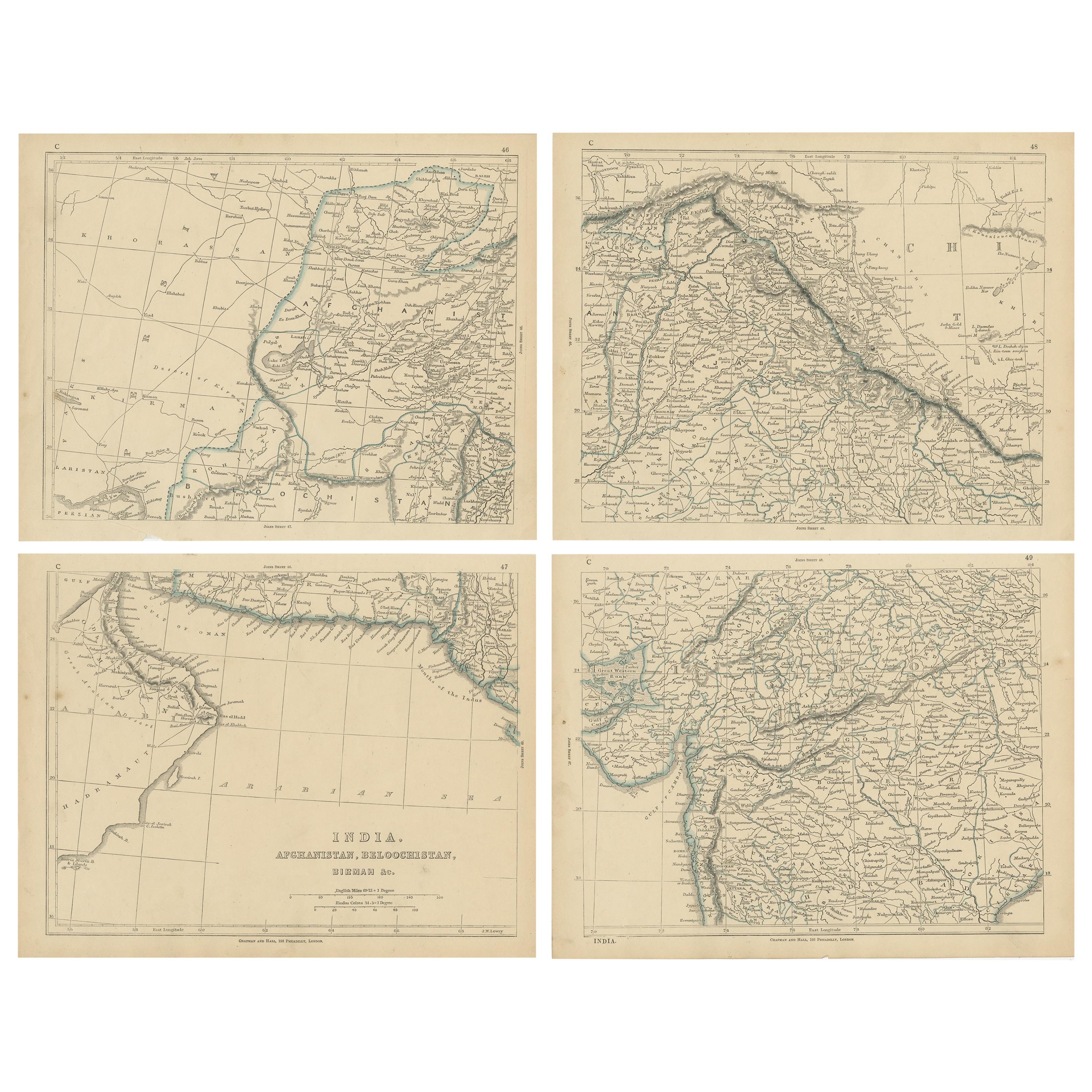
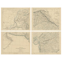
Antique Map of India, Afghanistan, Balochistan and surroundings by Lowry,
1852
Located in Langweer, NL
Antique map titled 'India, Afghanistan, Beloochistan, Birmah & C'. Four individual sheets of India, Afghanistan, Baluchistan and surroundings. This map originates from 'Lowry's Table...
Category
Antique Mid-19th Century Maps
Materials
Paper
$238 Sale Price / set
20% Off
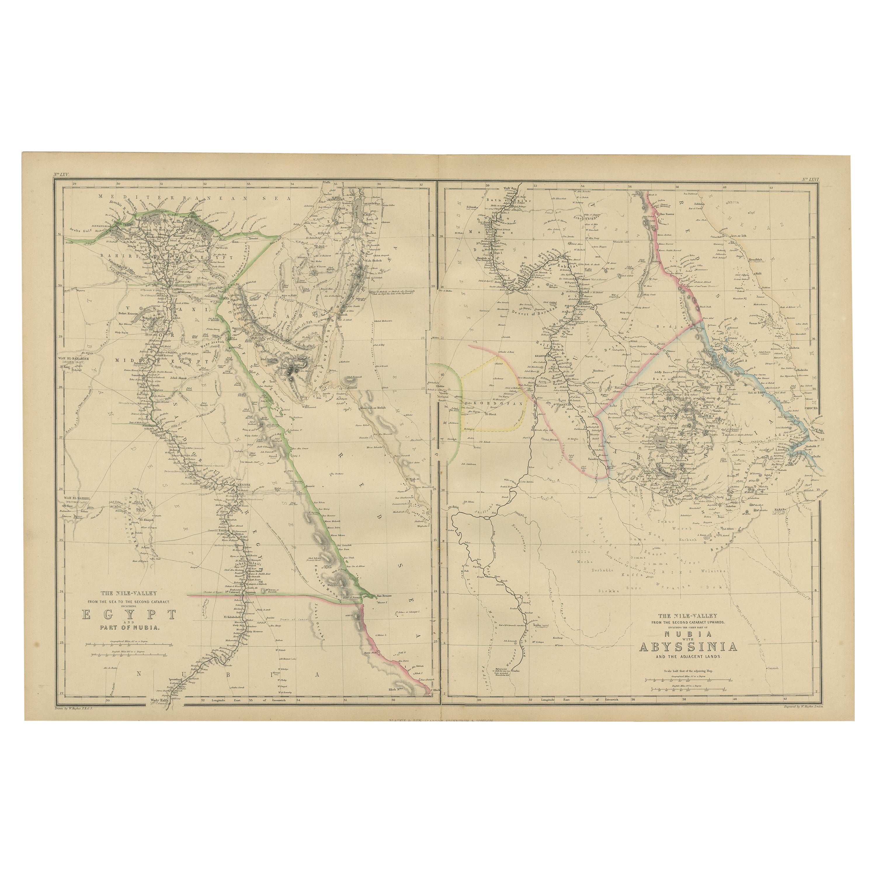
Antique Map of Egypt and Abyssinia by W. G. Blackie, 1859
Located in Langweer, NL
Antique map titled 'Egypt and Abyssinia'. Original antique map of Egypt and part of Nubia and Nubia with Abyssinia. This map originates from ‘The Imperial Atlas of Modern Geography’....
Category
Antique Mid-19th Century Maps
Materials
Paper
$238 Sale Price
20% Off
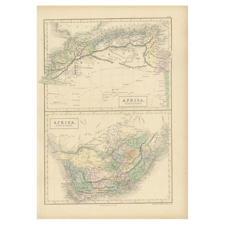
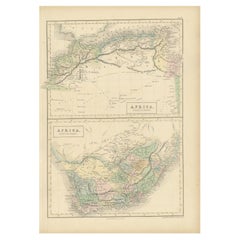
Antique Map of North Africa and South Africa by Black, 1854
Located in Langweer, NL
Antique map titled 'Africa north part - Africa south part'. Old map of Africa showing the region of Morocco, Algeria and South Africa. This map orginates from 'General Atlas Of The W...
Category
Antique 19th Century British Maps
Materials
Paper
You May Also Like
Original Antique Map of Africa by Dower, circa 1835
Located in St Annes, Lancashire
Nice map of Africa
Drawn and engraved by J.Dower
Published by Orr & Smith. C.1835
Unframed.
Free shipping
Category
Antique 1830s English Maps
Materials
Paper

Ancient Map of Senegal - Original Etching - 19th Century
Located in Roma, IT
Map of Senegal is an original etching realized by an anonymous engraver of the 19th Century.
Printed in series of "France Pittoresque" at the top center.
The state of preservation ...
Category
19th Century Figurative Prints
Materials
Etching

Large Original Antique Map of Afghanistan. Edward Weller, 1861
Located in St Annes, Lancashire
Great map of Afghanistan
Lithograph engraving by Edward Weller
Original colour
Published, 1861
Unframed
Good condition
Category
Antique 1860s English Victorian Maps
Materials
Paper

Map of Campaign of 1814 - Etching by Pierre François Tardieu - 1837
Located in Roma, IT
Map of Campaign of 1814 is an Etching realized by Pierre François Tardieu in 1837.
Good conditions.
The artwork is realized in a well-balanced composition. the artwork and belongs ...
Category
1830s Modern Figurative Prints
Materials
Lithograph

Map of Russia - Etching by Marco Di Pietro - 19th Century
Located in Roma, IT
This map of Russia is an etching realized by the Italian engraver Marco Di Pietro in 19th century.
The state of preservation of the artwork is excellent. The signature is engraved o...
Category
19th Century Old Masters Figurative Prints
Materials
Etching
West Africa Entitled "Guinea Propria": An 18th Century Hand Colored Homann Map
By Johann Baptist Homann
Located in Alamo, CA
This is a scarce richly hand colored copper plate engraved map of Africa entitled "Guinea Propria, nec non Nigritiae vel Terrae Nigrorum Maxima Pars" by Johann Baptist Homann (1664-1...
Category
Antique Mid-18th Century German Maps
Materials
Paper

More Ways To Browse
West Africa Map
Antique Nautical Charts
Antique Macedonia
Hemispheres Map
Java Map
Miniature Maps
Antique Maps Of Wales
Swiss Antiques And Collectables
Map Stand
Caribbean Antique Furniture
West Indies Furniture
Railroad Collectibles
Antique Map Denmark
American West Furniture
Antique Railroad Collectibles
Gold Maps
World Map Of Trade Routes
J Walker