Items Similar to Antique Map of Winchester, Eldorado
Orangeburg, 1871

Want more images or videos?
Request additional images or videos from the seller
1 of 5
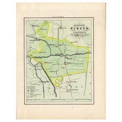
Antique Map of Winchester, Eldorado
Orangeburg, 1871
$239.43
$299.2920% Off
£179.06
£223.8220% Off
€200
€25020% Off
CA$329.93
CA$412.4120% Off
A$359.94
A$449.9320% Off
CHF 190.59
CHF 238.2420% Off
MX$4,313.16
MX$5,391.4520% Off
NOK 2,427.25
NOK 3,034.0620% Off
SEK 2,219.54
SEK 2,774.4220% Off
DKK 1,523.24
DKK 1,904.0520% Off
About the Item
Antique map titled 'Winchester, Eldorado, Orangeburg'. Original antique map of villages and communities of Ohio. This map originates from 'Atlas of Preble County Ohio' by C.O. Titus. Published, 1871.
- Dimensions:Height: 12.41 in (31.5 cm)Width: 14.97 in (38 cm)Depth: 0.02 in (0.5 mm)
- Materials and Techniques:
- Period:
- Date of Manufacture:1871
- Condition:Original folding lines. Shows some wear and foxing. General age-related toning. Few small defects in margins. Please study images carefully.
- Seller Location:Langweer, NL
- Reference Number:Seller: BG-11874-41stDibs: LU3054321717002
About the Seller
5.0
Recognized Seller
These prestigious sellers are industry leaders and represent the highest echelon for item quality and design.
Platinum Seller
Premium sellers with a 4.7+ rating and 24-hour response times
Established in 2009
1stDibs seller since 2017
2,792 sales on 1stDibs
Typical response time: <1 hour
- ShippingRetrieving quote...Shipping from: Langweer, Netherlands
- Return Policy
More From This Seller
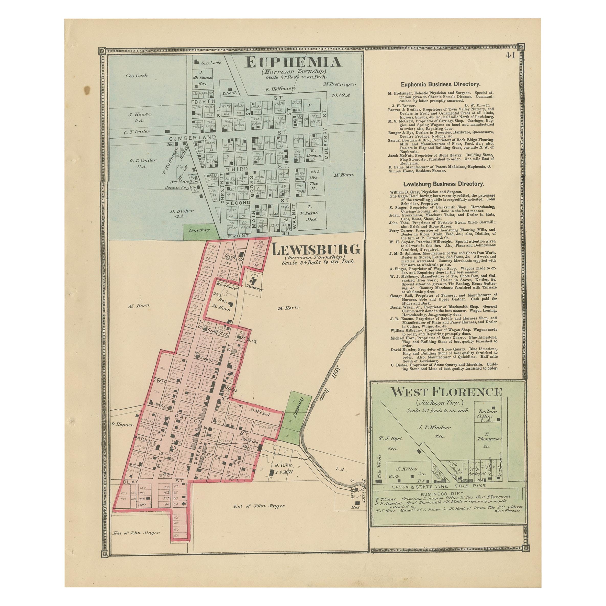
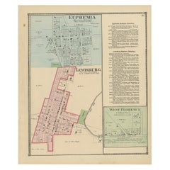
View AllAntique Map of Euphemia, Lewisburg
West Florence, 1871
Located in Langweer, NL
Antique map titled 'Euphemia, Lewisburg, West Florence'. Original antique map of villages and communities of Ohio. This map originates from 'Atlas of Preble County Ohio' by C.O. Titu...
Category
Antique Late 19th Century Maps
Materials
Paper
$239 Sale Price
20% Off
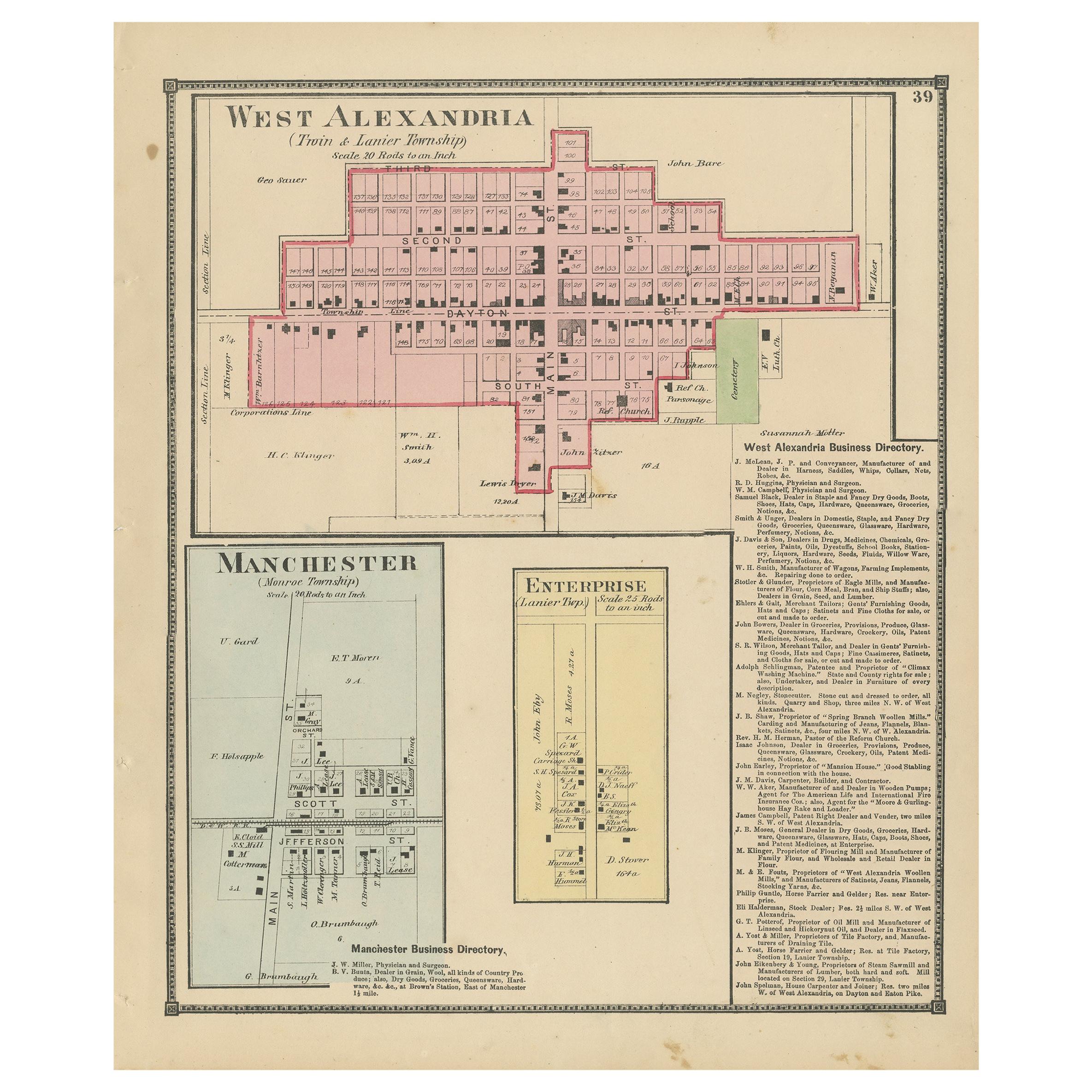
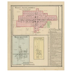
Antique Map of West Alexandria, Manchester
Enterprise, 1871
Located in Langweer, NL
Antique map titled 'West Alexandria, Manchester, Enterprise'. Original antique map of villages and communities of Ohio. This map originates from 'Atlas of Preble County Ohio' by C.O....
Category
Antique Late 19th Century Maps
Materials
Paper
$239 Sale Price
20% Off
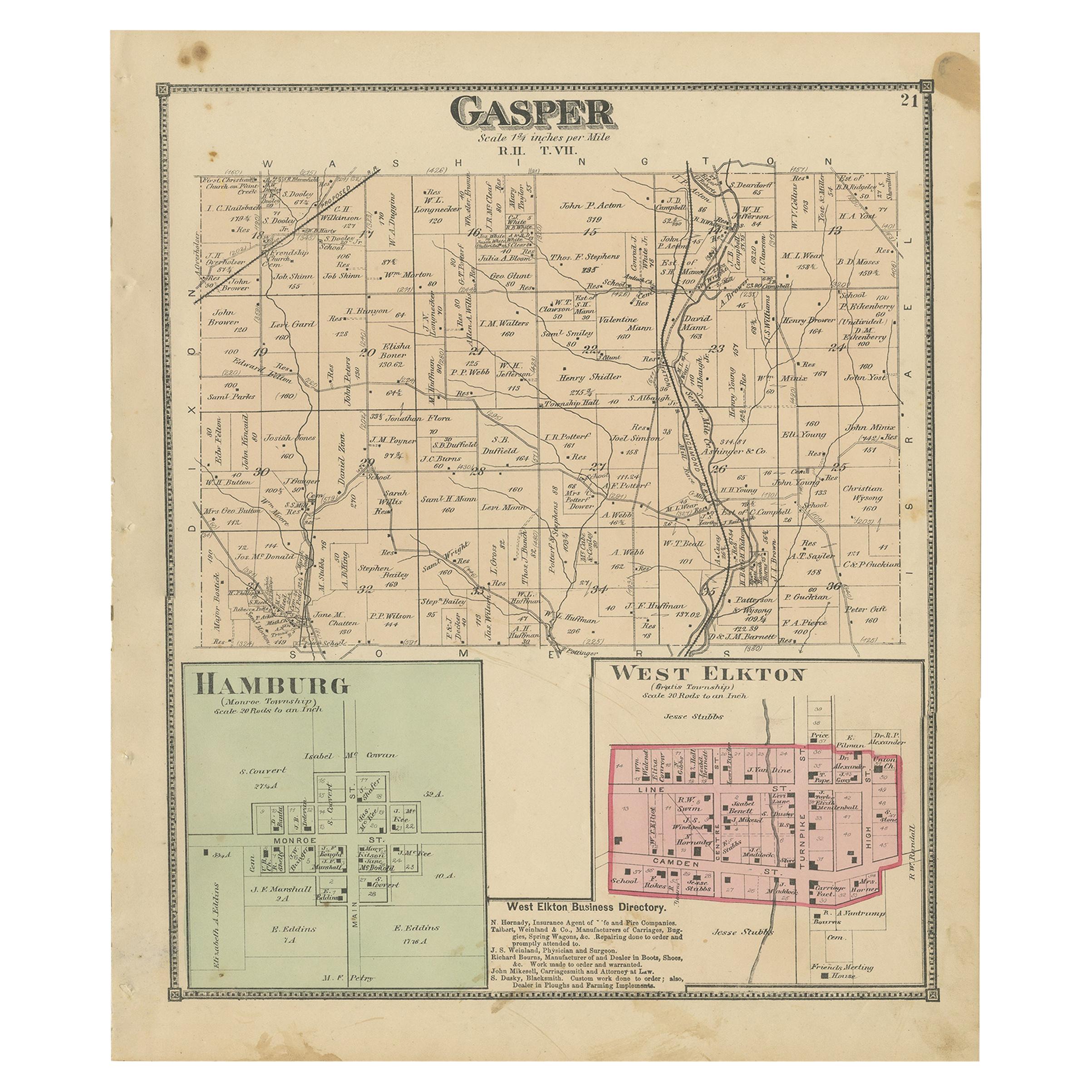
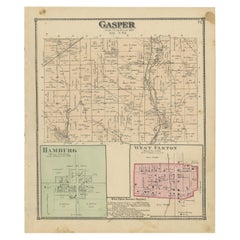
Antique Map of Gasper, Hamburg and West Elkton, 1871
Located in Langweer, NL
Antique map titled 'Gasper, Hamburg, West Elkton'. Original antique map of villages and communities of Ohio. This map originates from 'Atlas of Preble County Ohio' by C.O. Titus. Pub...
Category
Antique Late 19th Century Maps
Materials
Paper
$239 Sale Price
20% Off
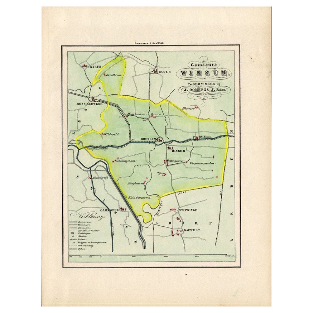
Antique Map of the Township of Winsum, Groningen in The Netherlands, 1862
Located in Langweer, NL
Groningen: Gemeente Obergum-Winsum. These scarse detailed maps of Dutch Towns originate from the 'Gemeente atlas van de Provincie Groningen in 62 kaarten.' by C. Fehse. This atlas of...
Category
Antique 19th Century Maps
Materials
Paper
$162 Sale Price
20% Off
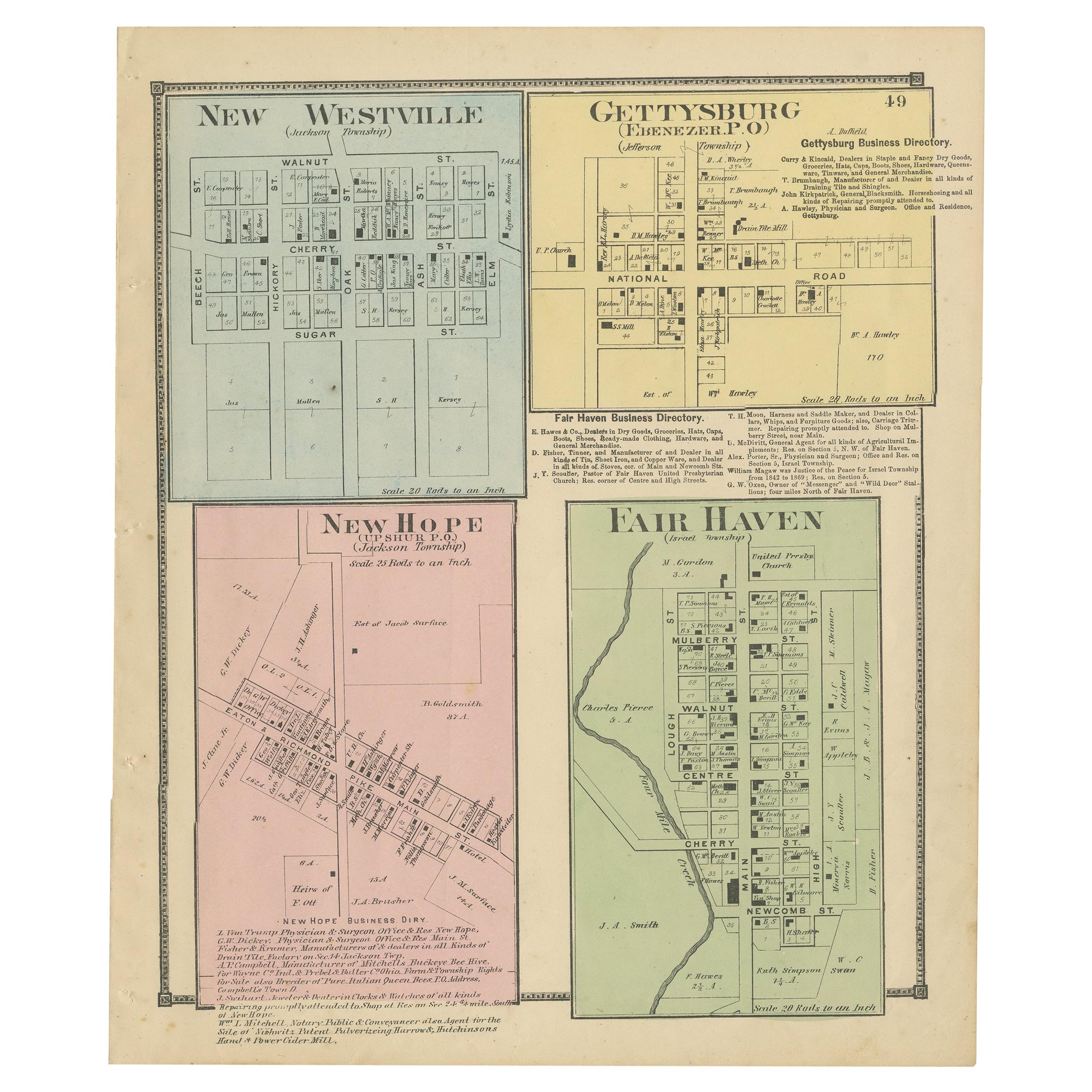
Antique Map of New Westville, Gettysburg, New Hope
Fair Haven, 1871
Located in Langweer, NL
Antique map titled 'New Westville, Gettysburg, New Hope, Fair Haven'. Original antique map of villages and communities of Ohio. This map originates from 'Atlas of Preble County Ohio'...
Category
Antique Late 19th Century Maps
Materials
Paper
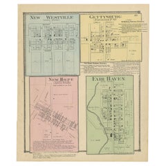
$239 Sale Price
20% Off
Antique Map of the Region of Winschoten, Groningen in The Netherlands, 1862
Located in Langweer, NL
Groningen: Gemeente Arrondisement Winschoten. These scarse detailed maps of Dutch Towns originate from the 'Gemeente atlas van de Provincie Groningen in 62 kaarten.' by C. Fehse. Thi...
Category
Antique 19th Century Maps
Materials
Paper
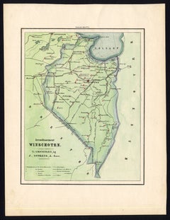
$181 Sale Price
20% Off
You May Also Like
Original Antique English County Map, Buckinghamshire, J
C Walker, 1851
Located in St Annes, Lancashire
Great map of Buckinghamshire
Original colour
By J & C Walker
Published by Longman, Rees, Orme, Brown & Co. 1851
Unframed.
Category
Antique 1850s English Other Maps
Materials
Paper

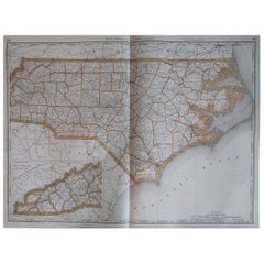
Large Original Antique Map of North Carolina, USA, 1894
By Rand McNally
Co.
Located in St Annes, Lancashire
Fabulous map of North Carolina
Original color
By Rand, McNally & Co.
Published, 1894
Unframed
Free shipping.
Category
Antique 1890s American Maps
Materials
Paper
Large Original Antique City Plan of Montreal, Canada, circa 1900
By Rand McNally
Co.
Located in St Annes, Lancashire
Fabulous colorful map of Montreal
Original color
By Rand, McNally & Co.
Published, circa 1900
Unframed
Minor edge tears
Free shipping.
Category
Antique Early 1900s American Maps
Materials
Paper

Original Antique English County Map, Huntingdonshire, J
C Walker, 1851
Located in St Annes, Lancashire
Great map of Huntingdonshire
Original colour
By J & C Walker
Published by Longman, Rees, Orme, Brown & Co. 1851
Unframed.
Category
Antique 1850s English Other Maps
Materials
Paper

Original Antique English County Map, Cambridgeshire, J
C Walker, 1851
Located in St Annes, Lancashire
Great map of Cambridgeshire
Original colour
By J & C Walker
Published by Longman, Rees, Orme, Brown & Co. 1851
Unframed.
Category
Antique 1850s English Other Maps
Materials
Paper

Original Antique Map of the American State of Illinois ( Southern Part ), 1903
Located in St Annes, Lancashire
Antique map of Illinois ( Southern part )
Published By A & C Black. 1903
Original colour
Good condition
Unframed.
Free shipping
Category
Antique Early 1900s English Maps
Materials
Paper

More Ways To Browse
Antique Ohio Maps
Eldorado Furniture
Antique Nautical Charts
Antique Macedonia
Hemispheres Map
Java Map
Miniature Maps
Antique Maps Of Wales
Swiss Antiques And Collectables
Map Stand
Caribbean Antique Furniture
West Indies Furniture
Railroad Collectibles
Antique Map Denmark
American West Furniture
Antique Railroad Collectibles
Gold Maps
World Map Of Trade Routes