Items Similar to Antique Map of the World Showing the Distribution of Plants and Minerals, 1872


Want more images or videos?
Request additional images or videos from the seller
1 of 10
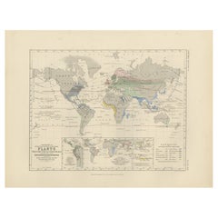
Antique Map of the World Showing the Distribution of Plants and Minerals, 1872
$189.85
$237.3120% Off
£141.73
£177.1620% Off
€160
€20020% Off
CA$263.76
CA$329.7020% Off
A$283.71
A$354.6420% Off
CHF 151.62
CHF 189.5320% Off
MX$3,344.12
MX$4,180.1520% Off
NOK 1,911.60
NOK 2,389.5020% Off
SEK 1,747.57
SEK 2,184.4620% Off
DKK 1,219.38
DKK 1,524.2220% Off
About the Item
Antique map titled 'Johnson's World showing the distribution of the Characteristic Forest Trees (..)'. Original world map showing the distribution of plants and minerals over the globe. This map originates from 'Johnson's New Illustrated Family Atlas of the World' by A.J. Johnson. Published, 1872.
- Dimensions:Height: 13.39 in (34 cm)Width: 16.93 in (43 cm)Depth: 0.02 in (0.5 mm)
- Materials and Techniques:
- Period:
- Date of Manufacture:1872
- Condition:General age-related toning, shows minor wear and creasing. Some soiling. English text on verso. Please study images carefully.
- Seller Location:Langweer, NL
- Reference Number:Seller: BG-12592-131stDibs: LU3054321465272
About the Seller
5.0
Recognized Seller
These prestigious sellers are industry leaders and represent the highest echelon for item quality and design.
Platinum Seller
Premium sellers with a 4.7+ rating and 24-hour response times
Established in 2009
1stDibs seller since 2017
2,836 sales on 1stDibs
Typical response time: 1 hour
- ShippingRetrieving quote...Shipping from: Langweer, Netherlands
- Return Policy
More From This Seller
View AllAntique Map Showing the Distribution of Plants by Johnston
1850
Located in Langweer, NL
Antique map titled 'Geographical plants which are used as food for man'. Original antique map showing the distribution of plants. This map originates from 'The Physical Atlas of Natu...
Category
Antique Mid-19th Century Maps
Materials
Paper
$189 Sale Price
20% Off
Antique Map Showing the Distribution of Plants by Johnston,
1850
Located in Langweer, NL
Antique map titled 'Geographical Distribution of Plants'. Original antique map showing the distribution of plants. This map originates from 'The Physical Atlas of Natural Phenomena' ...
Category
Antique Mid-19th Century Maps
Materials
Paper

$189 Sale Price
20% Off
Antique Map showing Isotherm Lines throughout the World by Johnston
1850
Located in Langweer, NL
Antique map titled 'Humboldt's System of Isothermal Lines'. Original antique map showing isotherm lines throughout the world. This map originates from 'The Physical Atlas of Natural ...
Category
Antique Mid-19th Century Maps
Materials
Paper

$189 Sale Price
20% Off
Antique Map Showing the Religions Around the World by Johnston
1854
Located in Langweer, NL
Antique map titled 'Moral & Statistical Chart showing the Geographical Distribution of Man According to Religious Belief'. Rare large-size thematic map on the distribution of religio...
Category
Antique Mid-19th Century Maps
Materials
Paper

$925 Sale Price
35% Off
Antique Map of the World by Johnson,
1872
Located in Langweer, NL
Antique map titled 'Johnson's World. Original world map. This map originates from 'Johnson's New Illustrated Family Atlas of the World' by A.J. John...
Category
Antique Late 19th Century Maps
Materials
Paper

$444 Sale Price
25% Off
Antique Map Showing the Division and Distribution of Mammals by Johnston
1850
Located in Langweer, NL
Antique map titled 'Geographical division and distribution of mammiferous animals of the orders rodentia and ruminantia over the globe'. Original antique map showing geographical div...
Category
Antique Mid-19th Century Maps
Materials
Paper

$189 Sale Price
20% Off
You May Also Like
Large Original Antique Map of The World, Fullarton, C.1870
Located in St Annes, Lancashire
Great map of the World. Showing both hemispheres
From the celebrated Royal Illustrated Atlas
Lithograph. Original color.
Published by Fullarton, Edinburgh, C.1870
Unframed.
Rep...
Category
Antique 1870s Scottish Maps
Materials
Paper

1864 Original illustrated planisphere - World Map - Geography
Located in PARIS, FR
Immerse yourself in the epic journey of the past with the Illustrated Historical Planisphere of 1864 by Charpentier! 🗺️ This cartographic treasure transports you through the intrica...
Category
1860s Prints and Multiples
Materials
Linen, Paper, Lithograph

Original Antique Map of The World by Thomas Clerk, 1817
Located in St Annes, Lancashire
Great map of The Eastern and Western Hemispheres
On 2 sheets
Copper-plate engraving
Drawn and engraved by Thomas Clerk, Edinburgh.
Published by Mackenzie And Dent, 1817
...
Category
Antique 1810s English Maps
Materials
Paper

Original Antique Map of The World by Dower, circa 1835
Located in St Annes, Lancashire
Nice map of the World
Drawn and engraved by J.Dower
Published by Orr & Smith. C.1835
Unframed.
Free shipping
Category
Antique 1830s English Maps
Materials
Paper

Antique Map of Eastern Hemisphere from the collection of Thierry Despont
Located in New York, NY
Designed by Enrico Bonetti (E. Bonatti) and published by Francesco Vallardi Editore. Based on an earlier map by Evangelista Azzi (Ev. Azzi). Labeled as such at bottom edge of map.
T...
Category
Antique Late 19th Century Italian Maps
Materials
Canvas, Wood

Original Antique Map of The Western Hemisphere by Dower, circa 1835
Located in St Annes, Lancashire
Nice map of the Western Hemisphere
Drawn and engraved by J.Dower
Published by Orr & Smith. C.1835
Unframed.
Free shipping
Category
Antique 1830s English Maps
Materials
Paper

More Ways To Browse
19th Century World Map
Map Railroad
Antique Railroad Maps
Antique Maps Of Greece
Brazilian Antiques
Turkey Map
Map Of Japan
Antique Nautical Charts
Denmark Map
Antique Macedonia
Hemispheres Map
Java Map
Miniature Maps
Antique Maps Of Wales
Swiss Antiques And Collectables
Map Stand
Caribbean Antique Furniture
West Indies Furniture