Items Similar to Antique Map of the World in two Hemispheres by Keizer
de Lat, 1788


Want more images or videos?
Request additional images or videos from the seller
1 of 5
Antique Map of the World in two Hemispheres by Keizer
de Lat, 1788
$628.38
$897.6930% Off
£466.90
£667.0130% Off
€525
€75030% Off
CA$860.76
CA$1,229.6530% Off
A$939.04
A$1,341.4830% Off
CHF 498.05
CHF 711.5030% Off
MX$11,313.30
MX$16,161.8630% Off
NOK 6,321.18
NOK 9,030.2630% Off
SEK 5,787.22
SEK 8,267.4530% Off
DKK 3,999.38
DKK 5,713.4130% Off
About the Item
Antique map titled 'Kaart van de Twee platte Warelds Bollen (..)'. Interesting world map in two hemispheres. California shown as a labeled island with place names and an indented northern coast. It is touching the mainland in the center. Title in cartouche at top between hemispheres. Includes charts at top right and left.
This map originates from 'Nieuwe Natuur- Geschied- en Handelkundige Zak- en Reisatlas' by Gerrit Brender à Brandis. Published by J. Keizer and I. de Lat, 1788.
- Dimensions:Height: 8.08 in (20.5 cm)Width: 13 in (33 cm)Depth: 0.02 in (0.5 mm)
- Materials and Techniques:
- Period:
- Date of Manufacture:1788
- Condition:Few splits, slightly affecting image. General age-related toning. Original folding lines. Original/contemporary hand coloring, blank verso. Minor wear, please study image carefully.
- Seller Location:Langweer, NL
- Reference Number:Seller: BG-12854-31stDibs: LU3054321978162
About the Seller
5.0
Recognized Seller
These prestigious sellers are industry leaders and represent the highest echelon for item quality and design.
Platinum Seller
Premium sellers with a 4.7+ rating and 24-hour response times
Established in 2009
1stDibs seller since 2017
2,820 sales on 1stDibs
Typical response time: 1 hour
- ShippingRetrieving quote...Shipping from: Langweer, Netherlands
- Return Policy
More From This Seller
View AllAntique Map of the World in Hemispheres by Keizer
de Lat, 1788
Located in Langweer, NL
Antique map titled 'Schuine Ronde Aard-Bolle waar van 't Middelpunt is Amsterdam (..)'. Interesting double hemisphere world map on polar projections. In North America, there is a large Island of California. Australia and New Zealand are shown with incomplete coastlines. The map contains six smaller astronomical...
Category
Antique Late 18th Century Maps
Materials
Paper

$478 Sale Price
20% Off
Antique Map of the World on Mercator
s Projection, 1788
Located in Langweer, NL
Antique map titled 'Kaart van de Geheele Wereld (..)'. Uncommon small world map on Mercator's projection. Nice detail of the islands throughout the wor...
Category
Antique Late 18th Century Maps
Materials
Paper

$718 Sale Price
20% Off
Original Engraved Antique Map of the World, Colorful and Decorative, C.1780
By Pierre François Tardieu
Located in Langweer, NL
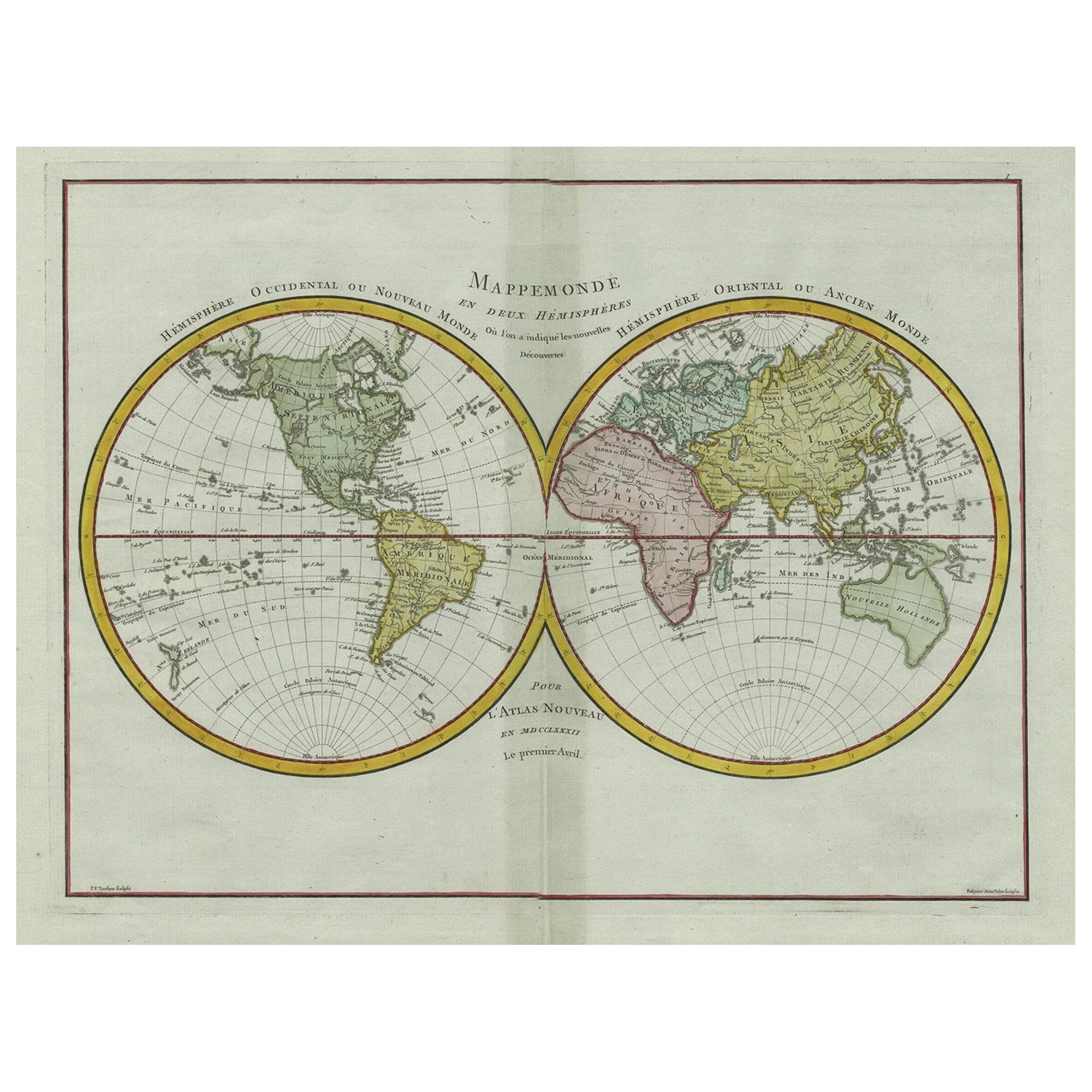
Antique map titled 'Mappemonde en Deux Hemispheres ou l'on a Indique les Nouvelles Decouvertes' - This handsome double hemisphere map presents a ...
Category
Antique 18th Century Maps
Materials
Paper

$450 Sale Price
20% Off
Antique Map of the World with Polar Projections by Keizer
de Lat, 1788
Located in Langweer, NL
Antique map titled 'Schuine Ronde Aard-Klooten (..)'. Interesting double hemisphere world map with polar projections. In North America, there is a...
Category
Antique Late 18th Century Maps
Materials
Paper

$448 Sale Price
25% Off
Very Decorative Original Antique Map of the World, Published in France in c.1780
By Rigobert Bonne
Located in Langweer, NL
Antique map titled 'L'Ancien Monde Et Le Nouveau en Deux Hemispheres' - Double hemisphere map of the World, showing the contemporary geographical...
Category
Antique 18th Century French Maps
Materials
Paper

$552 Sale Price
40% Off
Interesting Antique Engraving of the World in Hemispheres with 6 Diagrams, 1788
Located in Langweer, NL
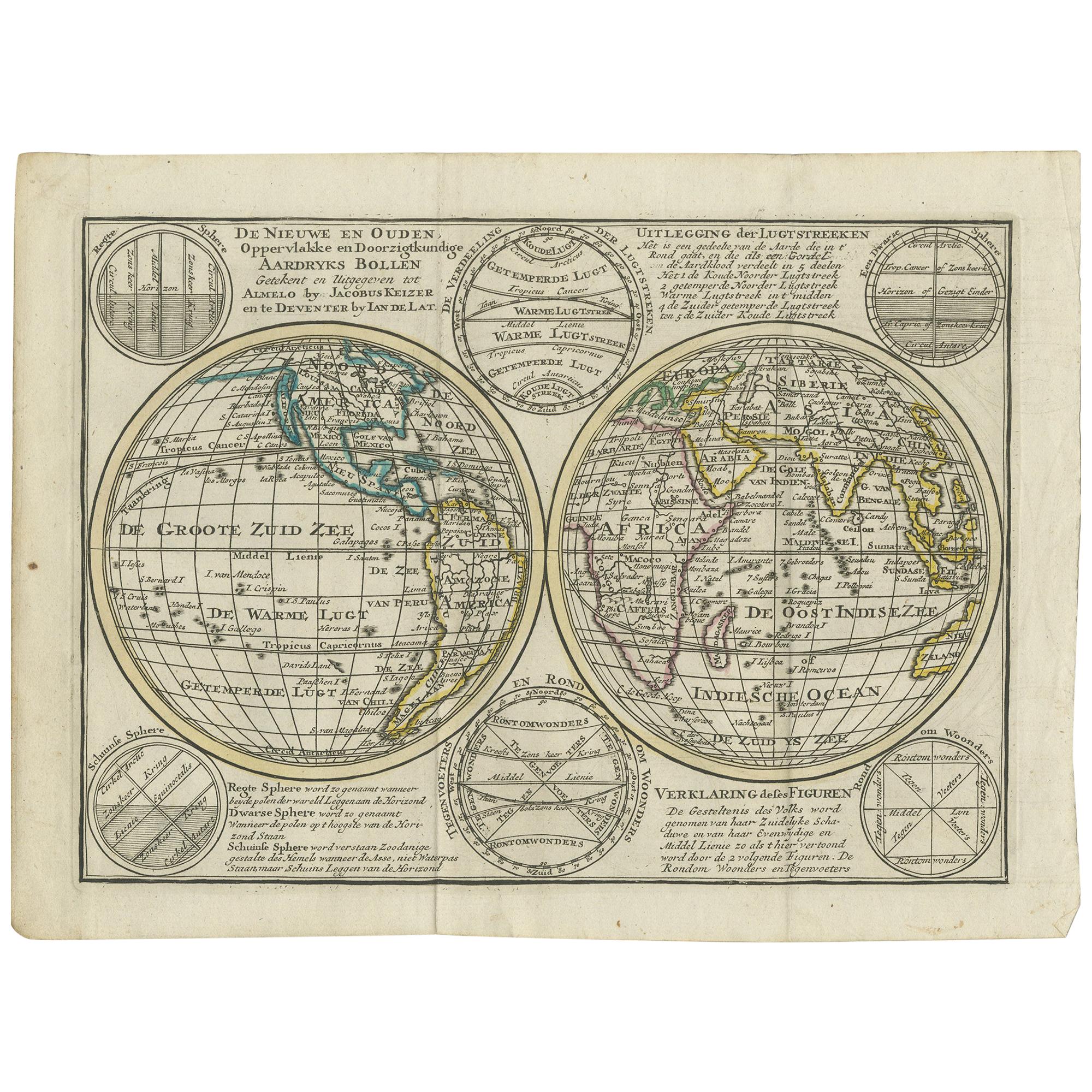
Antique map titled 'De Nieuwe en Ouden oppervlakke en doorzigtkundige Aardrykes Bollen (..)'. Twin hemispheres surrounded by six diagrams showing various divisions of the globe. Cali...
Category
Antique Late 18th Century Maps
Materials
Paper
$478 Sale Price
20% Off
You May Also Like
Original Antique Map of The World by Thomas Clerk, 1817
Located in St Annes, Lancashire
Great map of The Eastern and Western Hemispheres
On 2 sheets
Copper-plate engraving
Drawn and engraved by Thomas Clerk, Edinburgh.
Published by Mackenzie And Dent, 1817
...
Category
Antique 1810s English Maps
Materials
Paper

Original Antique Map of South America. C.1780
Located in St Annes, Lancashire
Great map of South America
Copper-plate engraving
Published C.1780
Two small worm holes to left side of map
Unframed.
Category
Antique Early 1800s English Georgian Maps
Materials
Paper

Original Antique Map of The World by Dower, circa 1835
Located in St Annes, Lancashire
Nice map of the World
Drawn and engraved by J.Dower
Published by Orr & Smith. C.1835
Unframed.
Free shipping
Category
Antique 1830s English Maps
Materials
Paper

North
South America: A 17th Century Hand-colored Map by Jansson
Goos
By Johannes Janssonius
Located in Alamo, CA
A 17th century hand-colored map of North & South America entitled "Americae Descriptio" by the cartographer Johannes Jansson, published in Jansson's Atlas Minor in Amsterdam in 1628....
Category
Antique 1620s Dutch Maps
Materials
Paper

$1,020 Sale Price
20% Off
Original Antique Map of The Western Hemisphere by Dower, circa 1835
Located in St Annes, Lancashire
Nice map of the Western Hemisphere
Drawn and engraved by J.Dower
Published by Orr & Smith. C.1835
Unframed.
Free shipping
Category
Antique 1830s English Maps
Materials
Paper

1850 Old French Map Depicting the Entire Earth
s Surface Divided into Two Parts
Located in Milan, IT
Geographical map depicting the entire earth's surface divided into two parts that correspond to the two hemispheres where the emerged lands are depicted which have been classified wi...
Category
Antique Mid-19th Century French Maps
Materials
Glass, Wood, Paper

More Ways To Browse
Antique Maps California
Miniature Maps
Antique Maps Of Wales
Swiss Antiques And Collectables
Map Stand
Caribbean Antique Furniture
West Indies Furniture
Railroad Collectibles
Antique Map Denmark
American West Furniture
Antique Railroad Collectibles
Gold Maps
World Map Of Trade Routes
J Walker
Mercator Map
Antique Map Of Switzerland
Albanian Antique
Antique Pamphlets