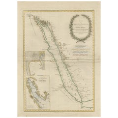
Items Similar to Antique Map of Yemen by Schraembl, 1789


Want more images or videos?
Request additional images or videos from the seller
1 of 5
Antique Map of Yemen by Schraembl, 1789
$863.97
$1,079.9620% Off
£640.26
£800.3220% Off
€720
€90020% Off
CA$1,180.79
CA$1,475.9920% Off
A$1,285.39
A$1,606.7420% Off
CHF 682.29
CHF 852.8620% Off
MX$15,466
MX$19,332.5120% Off
NOK 8,645.48
NOK 10,806.8520% Off
SEK 7,921.71
SEK 9,902.1320% Off
DKK 5,484.46
DKK 6,855.5720% Off
About the Item
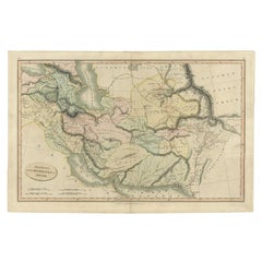
Antique map titled 'Karte von dem groessten Theil des Landes Jemen'. Original map of Yemen, this map is the first printed map specifically of Yemen, and the earliest map based on actual exploration of this region. It is derived from data collected by the German mathematician Carsten Niebuhr. It covers from what is now the western part of Yemen and the southwestern extents of Saudi Arabia. This map originates from the 'Allgemeiner Grosser Atlas' by Franz Anton Schraembl. Published, 1789.
- Dimensions:Height: 30.71 in (78 cm)Width: 23.23 in (59 cm)Depth: 0.02 in (0.5 mm)
- Materials and Techniques:
- Period:
- Date of Manufacture:1789
- Condition:Great condition, beautiful original/contemporary hand coloring. Original folding line. General age-related toning, blank verso. Please study images carefully.
- Seller Location:Langweer, NL
- Reference Number:Seller: BG-127471stDibs: LU3054321879462
About the Seller
5.0
Recognized Seller
These prestigious sellers are industry leaders and represent the highest echelon for item quality and design.
Platinum Seller
Premium sellers with a 4.7+ rating and 24-hour response times
Established in 2009
1stDibs seller since 2017
2,816 sales on 1stDibs
Typical response time: 1 hour
- ShippingRetrieving quote...Shipping from: Langweer, Netherlands
- Return Policy
More From This Seller
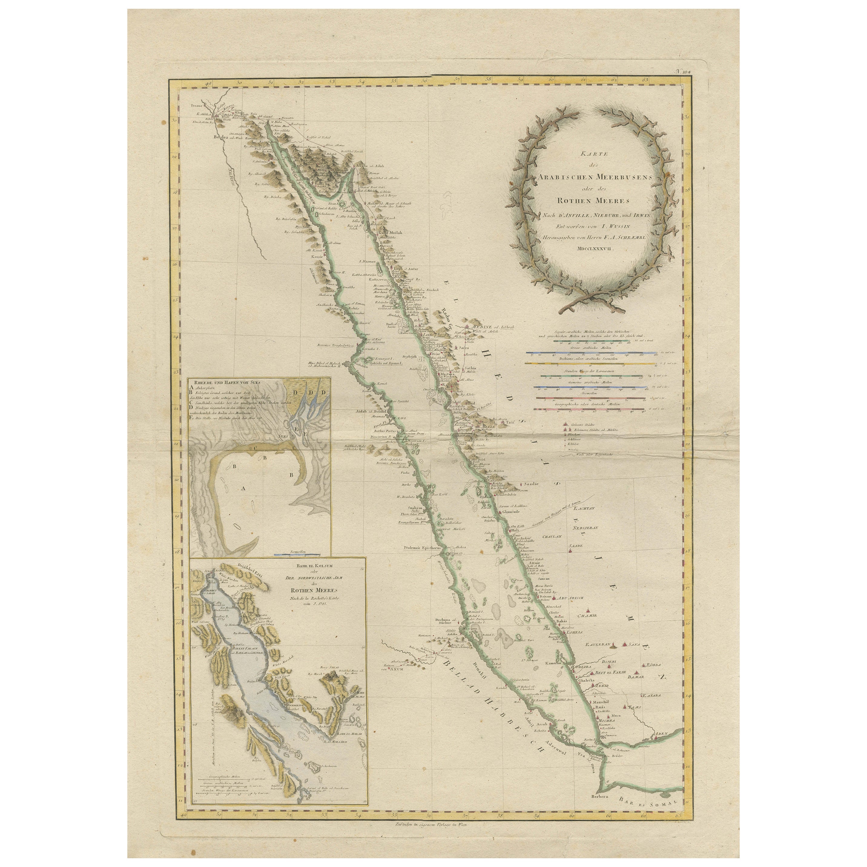
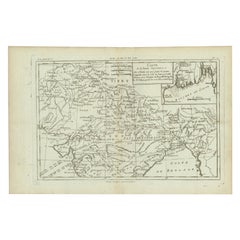
View AllImpressive Decorative Engraved Map of the Red Sea and Arabian Peninsula, 1787
Located in Langweer, NL
This map, titled "Karte des arabischen Meerbusens oder des Rothen Meeres," is an original engraving from 1787 created by F. A. Schraembl, based on the cartographic work of d'Anville.
It is a partially colored copper engraving.
Key features and notable details of the map include:
1. The title is prominently displayed within a large, ornate cartouche, enhancing the aesthetic appeal and indicating the map's subject as the Red Sea (Rothen Meeres).
2. The map covers the Red Sea and its surrounding regions, including significant portions of the Arabian Peninsula and northeastern Africa.
3. There are two detailed inset maps:
- The first inset map shows the roadstead of the port of Suez (Rheede des Hafen von Sues).
- The second inset map depicts Bahr el Kolsum, the northwestern arm of the Red Sea, based on a map by De la Rochette from 1785.
4. Geographical Features: The map meticulously details the coastline, islands, and notable port cities along the Red Sea. The cartography highlights both natural and man-made features, with elevations and mountains represented through hachures.
5. Condition and Preservation: The map has a horizontal centerfold and is partially backed to prevent tears. The edges of the map sheet show minor holes, tears, and faint brown spots, yet it remains in overall good condition considering its age.
6. Historical Importance: This map is a valuable historical document, reflecting the cartographic knowledge of the late 18th century. It serves as a significant piece for collectors interested in antique maps, particularly those focusing on the Arabian Peninsula and maritime navigation in the Red Sea region.
The map shows the coastline of the Red Sea and the Arabian Peninsula, detailing regions and places along the western coast of Saudi Arabia and Yemen, as well as the eastern coast of Egypt and Sudan. Here are some of the most important places identified on the map:
1. Jeddah (Gedda): A major city and port on the western coast of Saudi Arabia, significant for its role as a gateway for pilgrims traveling to Mecca.
2. Mecca (Mekka): A holy city in Islam, located inland from the Red Sea, important for being the site of pilgrimage (Hajj) for Muslims.
3. Medina (Medina): Another important Islamic city, known for the Prophet's Mosque and being a key pilgrimage site.
4. Suez (Suess): Located at the northern end of the Red Sea, near the Suez Canal, it's a crucial link between the Mediterranean Sea and the Red Sea.
5. Aden: A port city in Yemen, located at the southern tip of the Arabian Peninsula, historically significant as a trading hub.
6. Mocha (Mokka): A port city in Yemen, historically known for being a major marketplace for coffee.
7. Sana'a: The capital city of Yemen, noted for its historical and cultural significance.
8. Bab el Mandeb: The strait connecting the Red Sea to the Gulf of Aden, crucial for maritime navigation.
These locations are critical due to their historical, religious, and economic significance, especially in terms of trade routes and pilgrimage sites. The map also illustrates the mountainous terrain and coastal features of the region.
The condition and preservation status, which, despite minor imperfections, is considered well-preserved for its age.
Overall, this map is a rare and valuable artifact, offering both historical insights and aesthetic appeal for collectors and enthusiasts of antique cartography.
Category
Antique 1780s Maps
Materials
Paper
$1,216 Sale Price
40% Off
Free Shipping
Antique Map of the Arabian Peninsula by Bellin
c.1740
Located in Langweer, NL
Antique map titled 'Carte de la Coste d'Arabie, Mer Rouge et Golfe de Perse'. Original antique map of the Arabian Peninsula, labes both Mecca and Med...
Category
Antique Mid-18th Century Maps
Materials
Paper

Antique Map of the Arabian Peninsula by Franceschini,
1739
Located in Langweer, NL
Antique map titled 'Conventus et Residentiae'. Rare map of the Arabian Peninsula. This map originates from 'Provinciarum et Conventum Fratrum Discalc...
Category
Antique Mid-18th Century Maps
Materials
Paper

$539 Sale Price
40% Off
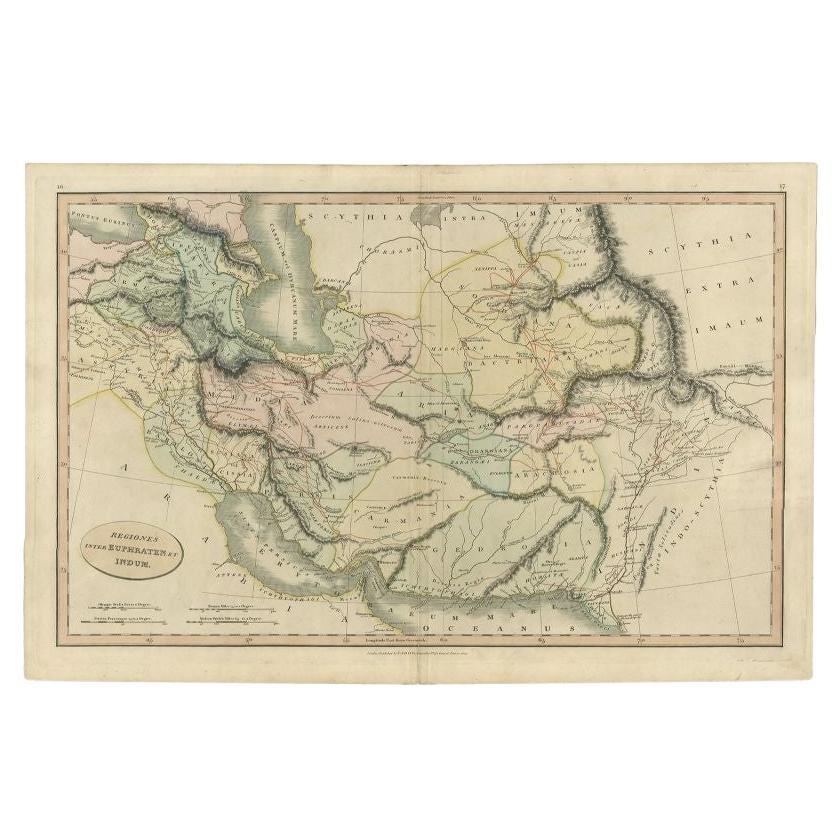
Antique Map of the Middle East by Smith, 1809
Located in Langweer, NL
Antique map titled 'Regiones inter Euphraten et Indum'. Old map of the Middle East showing the region between the Euphrates and Indus river. Ori...
Category
Antique 19th Century Maps
Materials
Paper
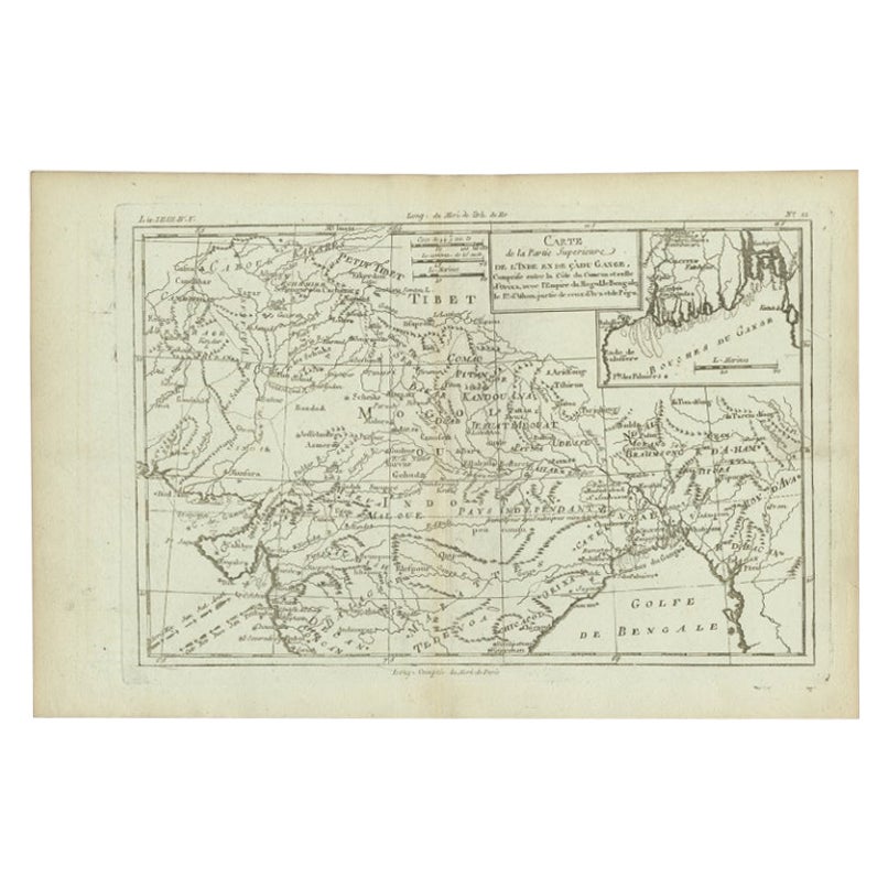
Antique Map of Part of Southern Asia by Bonne, c.1780
Located in Langweer, NL
Antique map titled 'Carte de la Partie Superieure de l'Inde en deca du Gange. Comprise entre la Cote du Concan et celle d'Orixa, avec l'Empire du Mogol, le Bengale, le R. d'Asham, pa...
Category
Antique 18th Century Maps
Materials
Paper
$120 Sale Price
20% Off
Antique Map of Persia by A. Zatta, circa 1785
Located in Langweer, NL
Antique map titled 'L'Impero della Persia diviso ne suoi Stati'. The Empire of Persia divided into its states. Originates from 'Atlante Novissimo, illustrato ed accresciuto sulle oss...
Category
Antique Late 18th Century Italian Maps
Materials
Paper

You May Also Like
Antique French Map of Asia Including China Indoneseia India, 1783
Located in Amsterdam, Noord Holland
Very nice map of Asia. 1783 Dedie au Roy.
Additional information:
Country of Manufacturing: Europe
Period: 18th century Qing (1661 - 1912)
Condition: Overall Condition B (Good Used)...
Category
Antique 18th Century European Maps
Materials
Paper

$486 Sale Price
40% Off
West Coast of Africa, Guinea
Sierra Leone: An 18th Century Map by Bellin
By Jacques-Nicolas Bellin
Located in Alamo, CA
Jacques Bellin's copper-plate map entitled "Partie de la Coste de Guinee Dupuis la Riviere de Sierra Leona Jusquau Cap das Palmas", depicting the coast of Guinea and Sierra Leone in ...
Category
Antique Mid-18th Century French Maps
Materials
Paper

$460 Sale Price
20% Off
Original Antique Map of Ancient Greece- Boeotia, Thebes, 1787
Located in St Annes, Lancashire
Great map of Ancient Greece. Showing the region of Boeotia, including Thebes
Drawn by J.D. Barbie Du Bocage
Copper plate engraving by P.F T...
Category
Antique 1780s French Other Maps
Materials
Paper

West Africa Entitled "Guinea Propria": An 18th Century Hand Colored Homann Map
By Johann Baptist Homann
Located in Alamo, CA
This is a scarce richly hand colored copper plate engraved map of Africa entitled "Guinea Propria, nec non Nigritiae vel Terrae Nigrorum Maxima Pars" by Johann Baptist Homann (1664-1...
Category
Antique Mid-18th Century German Maps
Materials
Paper

$1,500 Sale Price
20% Off
Map of Nubia and Abissinia - Original Etching by Antonio Zatta - 1784
Located in Roma, IT
This Map of Nubia and Abissinia is an etching realized by Antonio Zatta in Venice in 1784.
The state of preservation of the artwork is good expect for the worn paper with some littl...
Category
1770s Landscape Prints
Materials
Etching

1771 Bonne Map of Poitou, Touraine and Anjou, France, Ric.a015
Located in Norton, MA
1771 Bonne Map of Poitou,
Touraine and Anjou, France
Ric.a015
1771 Bonne map of Potiou, Touraine and Anjou entitled "Carte des Gouvernements D'Anjou et du Saumurois, de la Touraine, du Poitou,du Pays d'aunis, Saintonge?Angoumois,"
Carte des gouvernements d'Anjou et du Saumurois, de la Touraine, du Poitou, du Pays d'Aunis, Saintonge-Angoumois. Projettee et assujettie au ciel par M. Bonne, Hyd. du Roi. A Paris, Chez Lattre, rue St. Jacques a la Ville de Bord(ea)ux. Avec priv. du Roi. 1771. Arrivet inv. & sculp., Atlas moderne ou collection de cartes sur toutes...
Category
Antique 17th Century Unknown Maps
Materials
Paper

More Ways To Browse
Antique Yemen
Saudi Arabia Map
Miniature Maps
Antique Maps Of Wales
Swiss Antiques And Collectables
Map Stand
Caribbean Antique Furniture
West Indies Furniture
Railroad Collectibles
Antique Map Denmark
American West Furniture
Antique Railroad Collectibles
Gold Maps
World Map Of Trade Routes
J Walker
Mercator Map
Antique Map Of Switzerland
Albanian Antique