Items Similar to Antique Maps of the Malabar Coast – Valentyn, Cochin, and Malabar, 17


Want more images or videos?
Request additional images or videos from the seller
1 of 5
Antique Maps of the Malabar Coast – Valentyn, Cochin, and Malabar, 17
$963.90per set
£700per set
€818.63per set
CA$1,318.86per set
A$1,435.02per set
CHF 759.82per set
MX$17,264.21per set
NOK 9,648.06per set
SEK 8,827.30per set
DKK 6,116.33per set
About the Item
Antique Maps of the Malabar Coast – Valentyn, Cochin, and London Magazine, 17th–18th Century
Description:
This compilation of three antique maps and views offers a remarkable cross-section of how European cartographers and publishers represented the Malabar and Coromandel coasts of India between the late 17th and 18th centuries.
1. Nieuwe Kaart van Choromandel ende Malabar – François Valentyn, c.1726
The first map is a large and detailed Dutch engraving of southern India, extending from the Malabar Coast on the Arabian Sea to the Coromandel Coast along the Bay of Bengal, including parts of Ceylon (Sri Lanka). Compiled by François Valentyn, a historian of the Dutch East India Company (VOC), the map displays kingdoms such as Golconda, Carnatic, Gingee, Madurai, and Tanjore, alongside ports vital to VOC trade. Mountain ranges, rivers, settlements, and coastal forts are finely engraved, testifying to Dutch geographic and colonial interests in the region.
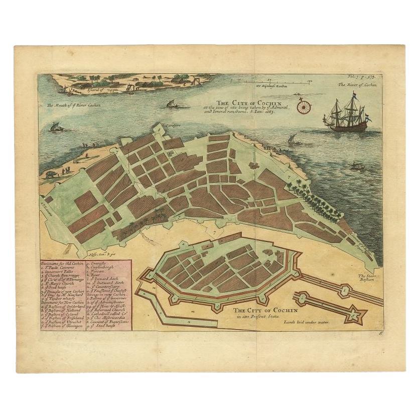
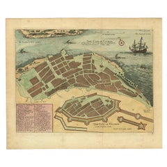
2. De Stad Coetsjien (Cochin on the Malabar Coast), c.1726
The second engraving, also associated with Valentyn’s monumental *Oud en Nieuw Oost-Indien*, is a detailed bird’s-eye view of the fortified city of Cochin (modern Kochi, Kerala). The city walls, streets, churches, and surrounding coconut groves are rendered with precision, along with the bustling harbor dotted with ships. Above the plan, a cross-section of the fortifications is shown, reflecting European military engineering influence in Indian port cities. This view emphasizes Cochin’s importance as a strategic base for spice trade and VOC dominance on the Malabar coast.
3. Chart of the Coast of Persia, Malabar, etc. – London Magazine, c.1750
The third map, engraved for the *London Magazine*, illustrates the wider Indian Ocean littoral from the Persian Gulf to the Maldives and Malabar coast. Based on French hydrographic charts, this English engraving was “regulated by Astronomical Observations” and intended for navigational use. It marks settlements and ports with symbols identifying Dutch, English, and Portuguese possessions. A decorative vignette in the lower left shows a fortress, cannons, and palm trees, underscoring the imperial and military rivalry that shaped the region.
Together, these three works chart the Malabar and Coromandel coasts at a critical period of European expansion, trade, and conflict. They complement one another by blending large-scale cartography, detailed urban representation, and wide-ranging maritime charts, making this a unique historical grouping for collectors of India maps or colonial cartography.
Condition report:
All three prints are in good condition with strong impressions. Some age-related toning, light marginal foxing, and minor creases are visible but unobtrusive. Wide margins are preserved, and the paper remains stable with no major tears or repairs.
Framing tips:
This trio would work beautifully as a wall display. Present them in matching black or dark wood frames with off-white or cream mounts to highlight the engraving detail. For dramatic effect, arrange them horizontally: the large Valentyn map on one side, the city view of Cochin in the center, and the London Magazine chart on the other, showcasing the full scope of cartographic representation.
- Dimensions:Height: 24.02 in (61 cm)Width: 21.26 in (54 cm)Depth: 0.01 in (0.2 mm)
- Sold As:Set of 3
- Materials and Techniques:Paper,Engraved
- Period:
- Date of Manufacture:circa 1800
- Condition:All three prints are in good condition with strong impressions. Some age-related toning, light marginal foxing, and minor creases are visible but unobtrusive. Wide margins are preserved, and the paper remains stable with no major tears or repairs.
- Seller Location:Langweer, NL
- Reference Number:Seller: Jak-877, BGRN-253, BGRN-0011stDibs: LU3054346377532
About the Seller
5.0
Recognized Seller
These prestigious sellers are industry leaders and represent the highest echelon for item quality and design.
Platinum Seller
Premium sellers with a 4.7+ rating and 24-hour response times
Established in 2009
1stDibs seller since 2017
2,816 sales on 1stDibs
Typical response time: 1 hour
- ShippingRetrieving quote...Shipping from: Langweer, Netherlands
- Return Policy
More From This Seller
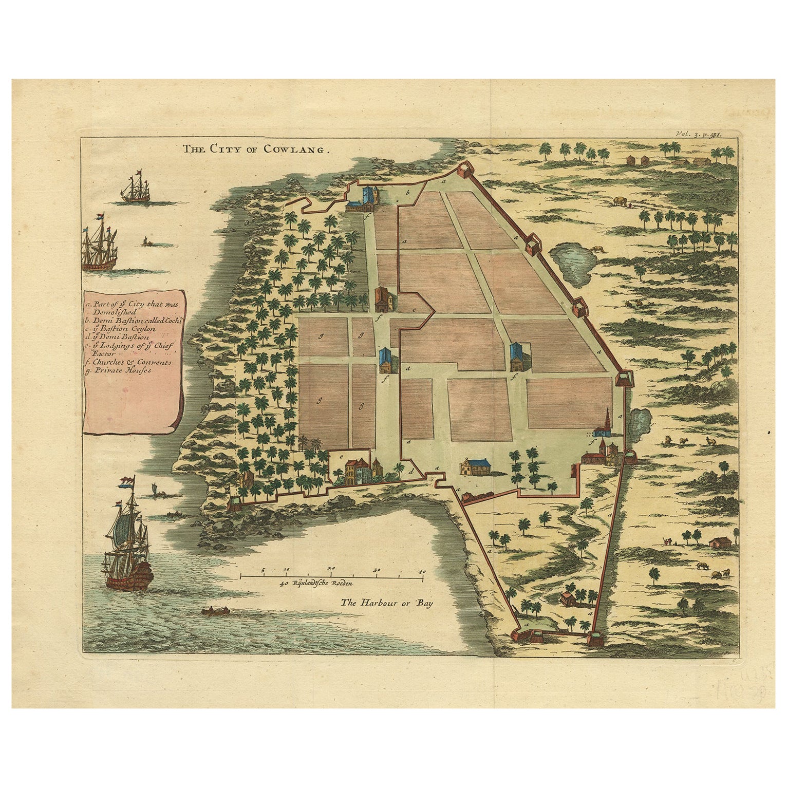
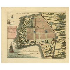
View AllThe City of Cowlang – Antique Map of Kollam (Quilon), India by Baldaeus, ca.1672
Located in Langweer, NL
The City of Cowlang – Antique Map of Kollam (Quilon), India by Philip Baldaeus, c.1672
Rare and beautifully hand-colored 17th-century bird’s-eye plan of the fortified coastal city o...
Category
Antique 1670s Dutch Maps
Materials
Paper
Very Attractive Handcolored Antique Plan of Cochin in India, 1744
By Philip Baldaeus
Located in Langweer, NL
Antique map titled 'The City of Cochin (..).' Plan of Cochin, Malabar Coast, India, during the attack by Admiral van Goens in 1663. This map was published in 'The True and Exact Desc...
Category
Antique 18th Century Maps
Materials
Paper
1705 Sanson Map of Southern India and Malabar with an Inset Map
Located in Langweer, NL
Title: 1705 Sanson Map of Southern India and Malabar with an Inset Map
Description: This finely engraved and beautifully hand-colored antique map, published in 1705, depicts south...
Category
Antique Early 1700s Maps
Materials
Paper

$739 Sale Price
20% Off
Original Old Map of the Environs of Batavia in the Dutch East Indies (Indonesia)
Located in Langweer, NL
Antique map titled 'Carte des Environs de Batavia'. Map of the environs of Batavia (now Jakarta), Indonesia. This print originates from volume 8 of 'Histoire générale des voyages'. P...
Category
Antique Mid-18th Century Maps
Materials
Paper

$288 Sale Price
20% Off
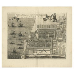
Rare 1681 Map of Batavia: Detailed Dutch Colonial Era Cartography, 1681
Located in Langweer, NL
The map of Batavia (modern-day Jakarta) from 1681, attributed to Frederick de Wit holds significant historical importance for several reasons:
Historical Context
1. Colonial Era: This map dates back to the Dutch colonial era when Batavia served as the administrative and commercial hub of the Dutch East India Company (VOC). The VOC was a powerful trading entity that played a crucial role in the global spice trade and colonization in Southeast Asia.
2. Strategic Importance: Batavia was strategically located on the northwestern coast of Java, providing the Dutch with a critical base for their maritime operations. The city became the center of Dutch political and military control in the region.
Cartographic Significance
1. Detailed Urban Layout: The map meticulously details the layout of Batavia, including its fortifications, canals, streets, and significant buildings. This level of detail provides insights into the urban planning and architectural styles of the period.
2. Military Engineering: The fortifications shown on the map illustrate the advanced military engineering techniques used by the Dutch to protect their valuable colony. The walls, bastions, and moats indicate the strategic considerations taken to defend against potential invasions.
3. Maritime Activity: The depiction of ships in the harbor highlights Batavia's role as a major maritime center. The VOC's fleets were essential for trade routes connecting Europe, Africa, and Asia, making Batavia a crucial node in global commerce.
Artistic and Cultural Value
1. Artistic Elements: The decorative elements, such as the lion holding a shield and the intricate cartouches, reflect the artistic trends of Dutch Golden Age cartography. These embellishments were not only informative but also served to display the cartographer's skill and the map's prestige.
2. Cultural Exchange: Maps like this one provide evidence of cultural exchange between the Dutch and the indigenous populations of Java. The blending of Dutch and local influences can be seen in various aspects of the map and the architecture of the city.
Rarity and Preservation
1. Rarity: Maps from the 17th century, especially those in good condition, are relatively rare and highly valued by collectors and historians. Each map provides a unique snapshot of historical geography and urban development.
2. Preservation of History: This map serves as a historical document, preserving knowledge about Batavia's cityscape, infrastructure, and colonial governance. It helps historians and scholars understand the socio-economic and political dynamics of the period.
Conclusion
The map of Batavia from 1681 is special due to its detailed depiction of one of the most important colonial cities in Southeast Asia during the Dutch Golden Age. It reflects the strategic, economic, and cultural significance of Batavia, serving as a valuable resource for understanding the history of Dutch colonialism and its global impact. The map's artistry and precision make it an important artifact in the history of cartography.
---------------
The map is an original and historical map of Batavia (present-day Jakarta) on the island of Java, dated 1681. There are several details to consider when evaluating its origins and possible authorship:
1. **Style and Detail**: The intricate details and style are reminiscent of maps created by Frederick de Wit, a prominent Dutch cartographer and engraver of the 17th century. He was known for his detailed city maps and sea charts.
2. **Lack of Signature**: The absence of "F. de Wit, Excudit" could indicate either an omission or a different engraver. However, it is essential to note that some maps from that period were reproduced or copied by other engravers and cartographers. This was not uncommon, as map-making was a collaborative effort, and copies of popular maps were frequently made.
3. **Map Characteristics**:
- The depiction of ships and the detailed fortifications are typical of Dutch cartography in the late 17th century.
- The decorative elements, such as the lion holding a shield, are also characteristic of Dutch map engravers.
4. **Other Possible Engravers**: While Frederick de Wit is a strong candidate, other notable Dutch engravers from that period include Joan Blaeu and Willem Janszoon Blaeu. They also produced highly detailed maps and could potentially be the creators or inspirers of this map.
To determine the precise authorship, you might consider:
- **Comparing** this map with other confirmed works of Frederick de Wit and his contemporaries to identify stylistic similarities and differences.
- **Historical Records**: Consulting historical records or publications related to Dutch cartography in the 17th century might provide more context or even direct references to this particular map.
If you have access to additional details or higher-resolution images of specific sections, it might help further pinpoint the map's origin and authorship.
-------------
Frederick de Wit (1629–1706) was a prominent Dutch cartographer, engraver, and publisher known for his detailed and decorative maps, atlases, and globes. He played a significant role in the Dutch Golden Age of cartography, contributing to the wealth of geographic knowledge and artistic achievement during this period. Here are key aspects of his life and work:
### Biography
- **Early Life**: Frederick de Wit was born in Gouda, Netherlands, in 1629. Little is known about his early years, but he moved to Amsterdam, the epicenter of Dutch cartography, in the mid-17th century.
- **Career Beginnings**: De Wit began his career as an engraver and publisher, initially producing maps that were reissues of earlier works by other cartographers, such as Joan Blaeu and Willem Janszoon Blaeu.
### Contributions to Cartography
- **Mapmaking**: De Wit was known for his meticulous attention to detail and artistic flair. He produced a wide range of maps, including world maps, regional maps, city plans, and maritime charts...
Category
Antique 1680s Maps
Materials
Paper
$5,668 Sale Price
20% Off
Free Shipping
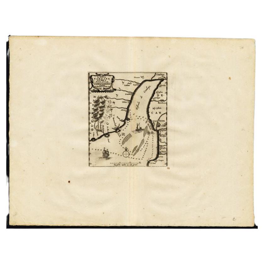
Antique Map of the Gulf of Cambay, Gujarat, India, 1725
By Pieter Van Der Aa
Located in Langweer, NL
Antique map titled 'Le Golfe de Cambaye at la Rade de Suratt.' (The gulf of Cambay and the coast of Surat, India.) The Gulf of Khambhat, formerly known as the Gulf of Cambay, is an i...
Category
Antique 18th Century Maps
Materials
Paper
You May Also Like
1597 German Map of Alexandria by Georg Braun and Frans Hogenberg
By Georg Braun and Frans Hogenberg
Located in Chapel Hill, NC
1597 Map of Alexandria by Georg Braun and Frans Hogenberg, Germany. From "Civitas Orbis Terrarum", part 2, published in Cologne by Bertram Buchholz. Printed in 2 parts. Title: "Alexa...
Category
Antique 16th Century German Renaissance Maps
Materials
Paper

$480 Sale Price
20% Off
Map Of India - Original Lithograph - 19th Century
Located in Roma, IT
Map of India is an original lithograph artwork realized by an Anonymous engraver of the 19th Century.
Printed in the series of "France Pittoresque".
Titled "France Pittoresque".
...
Category
19th Century Modern Figurative Prints
Materials
Lithograph

1633 Map "La Souverainete De Sedan Et De Raucourt, Et La Prevoste Ric0011
Located in Norton, MA
1653 map entitled
"La Souverainete de Sedan et de Raucourt, et la Prevoste de Doncheri,"
Ric0011
Description:
Lovely map centered on Sedan and Doncheri and the Meuze River fr...
Category
Antique 17th Century Dutch Maps
Materials
Paper

Antique Voc Print Holland Malaysia Old Map Melaka History, 1663
Located in Amsterdam, Noord Holland
From my own collection I offer this impressive Antique print of the city of Malakka
A very interesting piece for collectors . It is an museum piece from the Dutch Institute of Orien...
Category
Antique 17th Century European Paintings
Materials
Paper

$293 Sale Price
20% Off
Antique French Map of Asia Including China Indoneseia India, 1783
Located in Amsterdam, Noord Holland
Very nice map of Asia. 1783 Dedie au Roy.
Additional information:
Country of Manufacturing: Europe
Period: 18th century Qing (1661 - 1912)
Condition: Overall Condition B (Good Used)...
Category
Antique 18th Century European Maps
Materials
Paper

$486 Sale Price
40% Off
1646 Jansson Map Entitled "Procinvia Connactiae, " Ric.a006
Located in Norton, MA
1646 Jansson map entitled
"Procinvia connactiae,"
Ric.a006
Description: The PROVINCE of CONNAVGT 490 x 380From vol 4 of Jansson's Atlas Novus 1646, published in Amsterdam with...
Category
Antique 17th Century Unknown Maps
Materials
Paper
