Items Similar to Antique Maps of Manipa, Nusa-Laut, Saparua and Haruku in Maluku, Indonesia 1726
Want more images or videos?
Request additional images or videos from the seller
1 of 6
Antique Maps of Manipa, Nusa-Laut, Saparua and Haruku in Maluku, Indonesia 1726
$420.35
£311.37
€350
CA$575.14
A$625.80
CHF 331.35
MX$7,528.80
NOK 4,207.45
SEK 3,849.52
DKK 2,667.29
About the Item
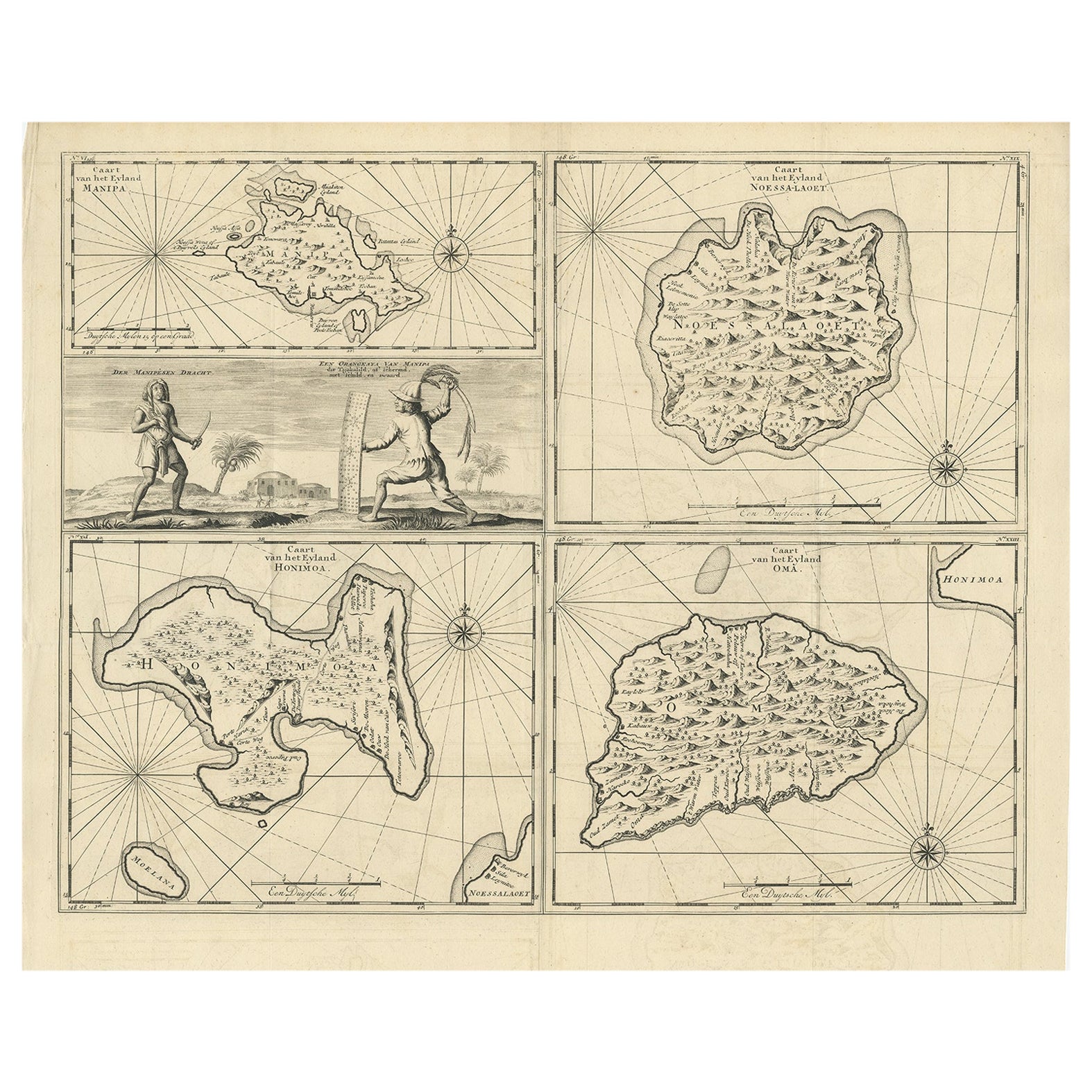
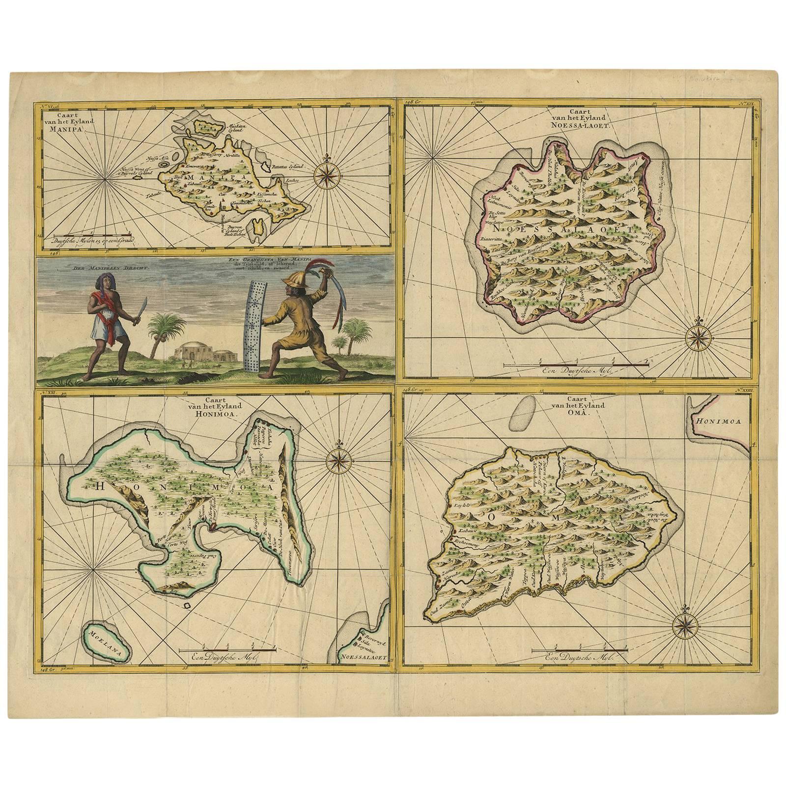
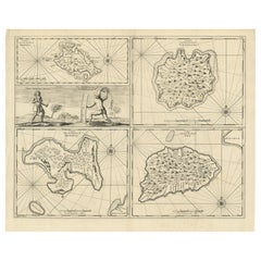
Antique map titled 'Caart van het Eyland Manipa, Noessa-Laoet, Honimoa, Oma. Der Manipesen dracht, een Orangkaya van Manipa.' Four maps of islands and two figures in native dress. The islands are: Manipa, Nusa-Laut (Noessa-Laoet), Saparua (Honimoa) and Haruku (Oma). These islands are all part of the Maluku Province of Indonesia, in the Pacific Ocean. Originates from "Oud en Nieuw Oost-Indiën" by François Valentyn / Valentijn, published in 1724-1726. Artists and Engravers: The author François Valentijn / Valentyn (1666-1727), was a Dutch missionary, worked at Amboina from 1684 to 1694 and 1705 to 1713 and traveled extensively in VOC lands.
Artist: The author François Valentijn / Valentyn (1666-1727), was a Dutch missionary, worked at Amboina from 1684 to 1694 and 1705 to 1713 and traveled extensively in VOC lands.
Condition: Very good, originally published as two sheets, joined. Some small splits on folding lines, left margin cut short but into the image. please study image carefully.
Date: 1726
Overall size: 65 x 55 cm.
Image size: 57 x 44 cm.
- Dimensions:Height: 25.6 in (65 cm)Width: 21.66 in (55 cm)Depth: 0 in (0.01 mm)
- Materials and Techniques:
- Period:
- Date of Manufacture:1726
- Condition:
- Seller Location:Langweer, NL
- Reference Number:Seller: BG-071731stDibs: LU3054326373432
About the Seller
5.0
Recognized Seller
These prestigious sellers are industry leaders and represent the highest echelon for item quality and design.
Platinum Seller
Premium sellers with a 4.7+ rating and 24-hour response times
Established in 2009
1stDibs seller since 2017
2,816 sales on 1stDibs
Typical response time: 1 hour
- ShippingRetrieving quote...Shipping from: Langweer, Netherlands
- Return Policy
More From This Seller
View AllAntique Map of Manipa and Other Maluku Islands, Indonesia, 1726
Located in Langweer, NL
Antique map titled 'Caart van het Eyland Manipa, Noessa-Laoet, Honimoa, Oma. Der Manipesen dracht, een Orangkaya van Manipa.'
Four maps of islands and two figures in native dress...
Category
Antique 18th Century Maps
Materials
Paper
Antique Map of Manipa, Nusa-Laut, Saparua
Haruku
Indonesia
by F. Valentijn
Located in Langweer, NL
Four maps of islands and two figures in native dress. The islands are: Manipa, Nusa-Laut (Noessa-Laoet), Saparua (Honimoa) and Haruku (Oma). These islands...
Category
Antique Early 18th Century Maps
Materials
Paper

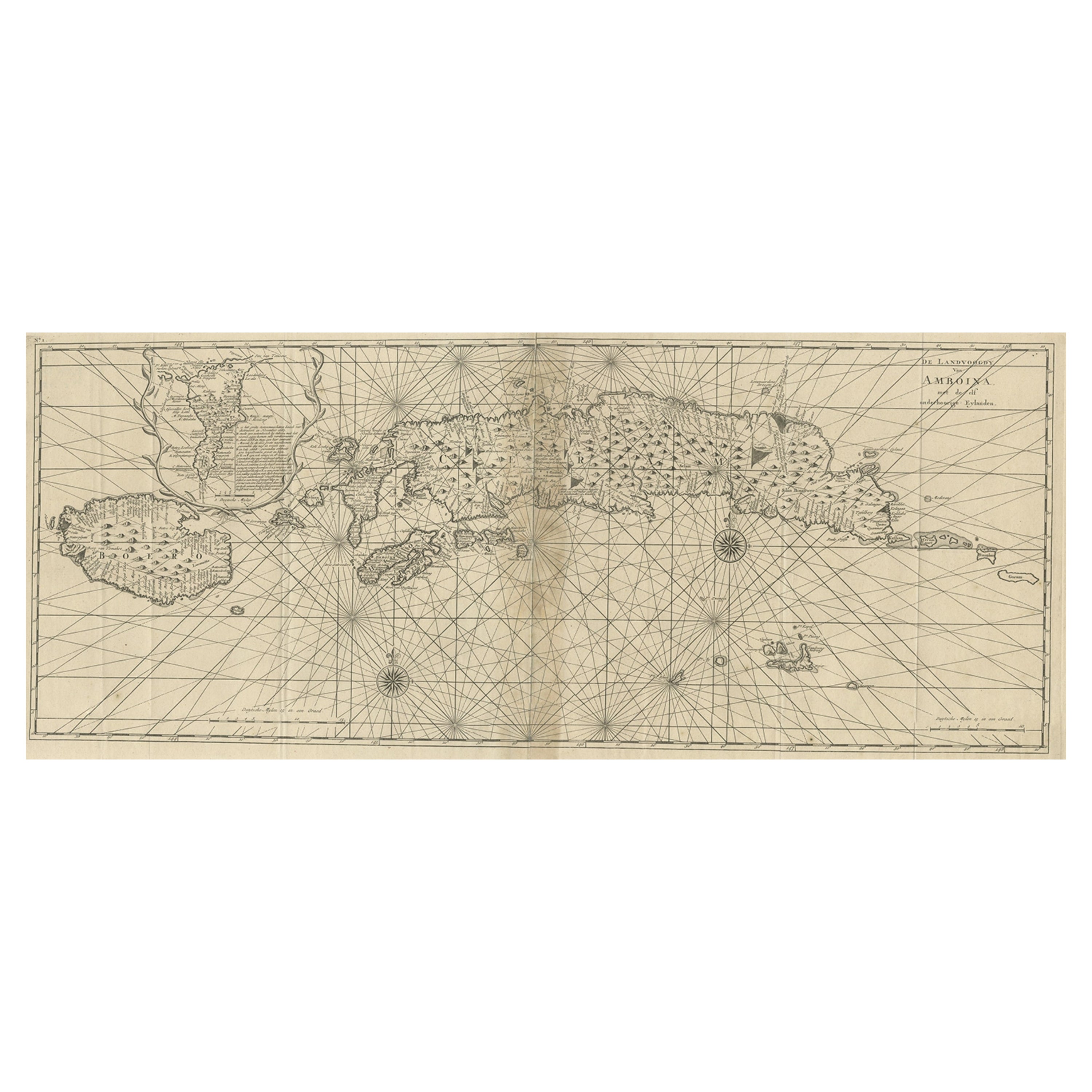
Antique Map of the Moluccas or the Famed Spice Islands of Indonesia, 1724
Located in Langweer, NL
Antique map Spice Islands titled 'De landvoogdy van Amboina met de elf onderhoorige Eylanden'.
This map depicts the central islands of the Maluku Arc...
Category
Antique 1720s Maps
Materials
Paper
$855 Sale Price
20% Off
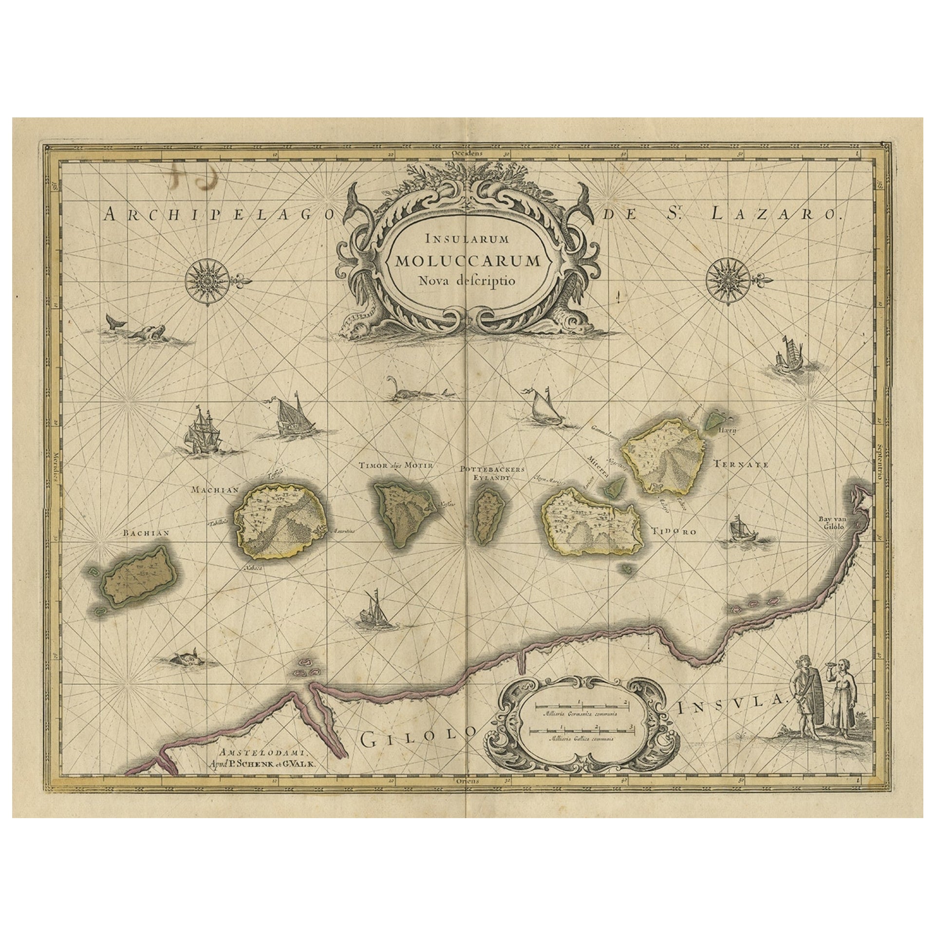
Old Map of the Moluccas, Known as the Famous Spice Islands, Indonesia, ca.1730
Located in Langweer, NL
Antique map titled 'Insularum Moluccarum Nova Descriptio.'
Old map of the Moluccas. The famous Spice Islands, the cornerstone of the Dutch trading empire in the East Indies throughout the 17th Century, is the focus of this exquisite map. Similar to Blaeu's map, except that it extends further south...
Category
Antique 1730s Maps
Materials
Paper

$662 Sale Price
20% Off
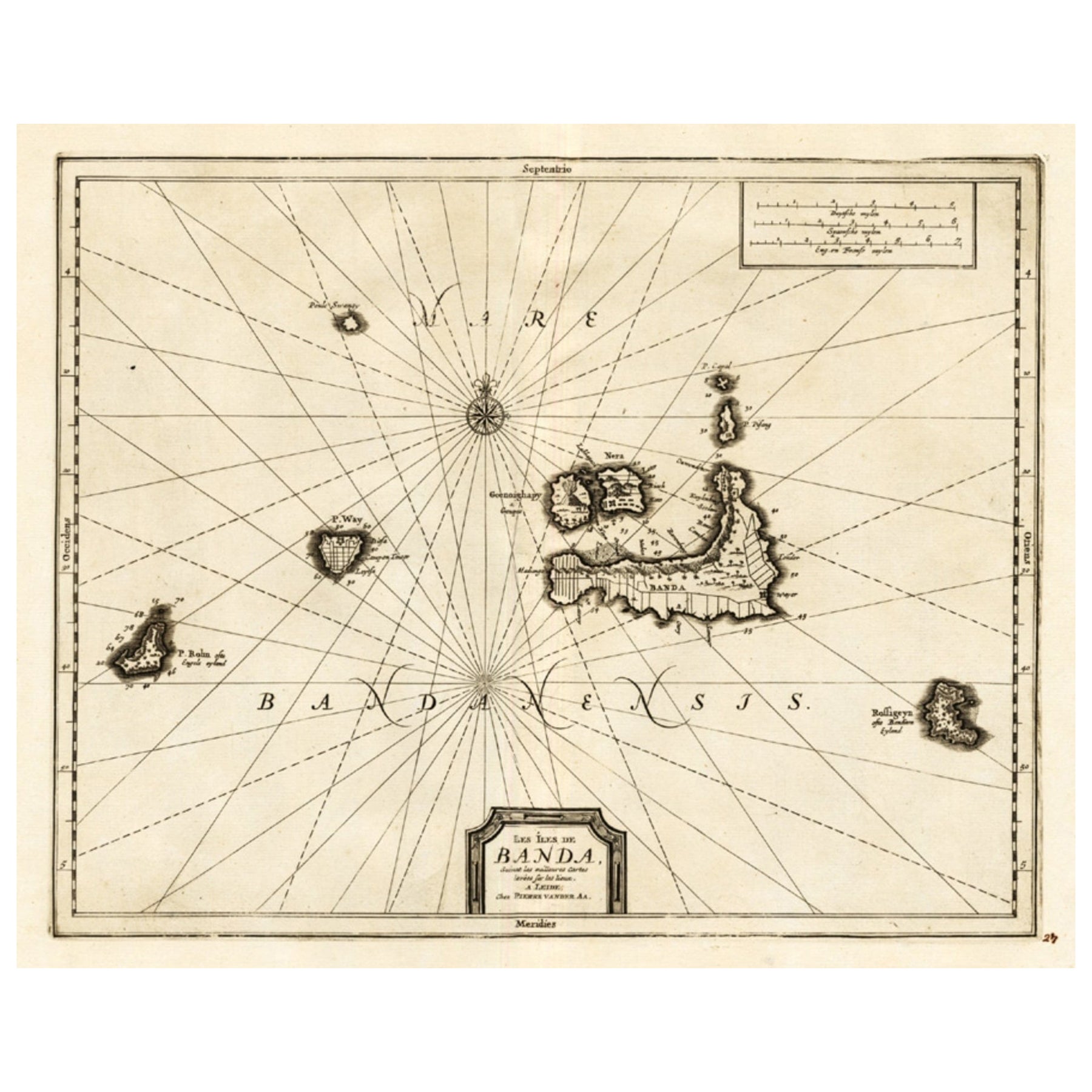
Antique Map of the Islands of Banda, Indonesia from a Very Rare Edition, 1725
Located in Langweer, NL
Antique map titled 'Les Iles de Banda (..).' (The islands of Banda, Indonesia.)
Extremely rare in this edition. This plate originates from the very scarse: 'La galerie agreable d...
Category
Antique 1720s Maps
Materials
Paper

$855 Sale Price
20% Off
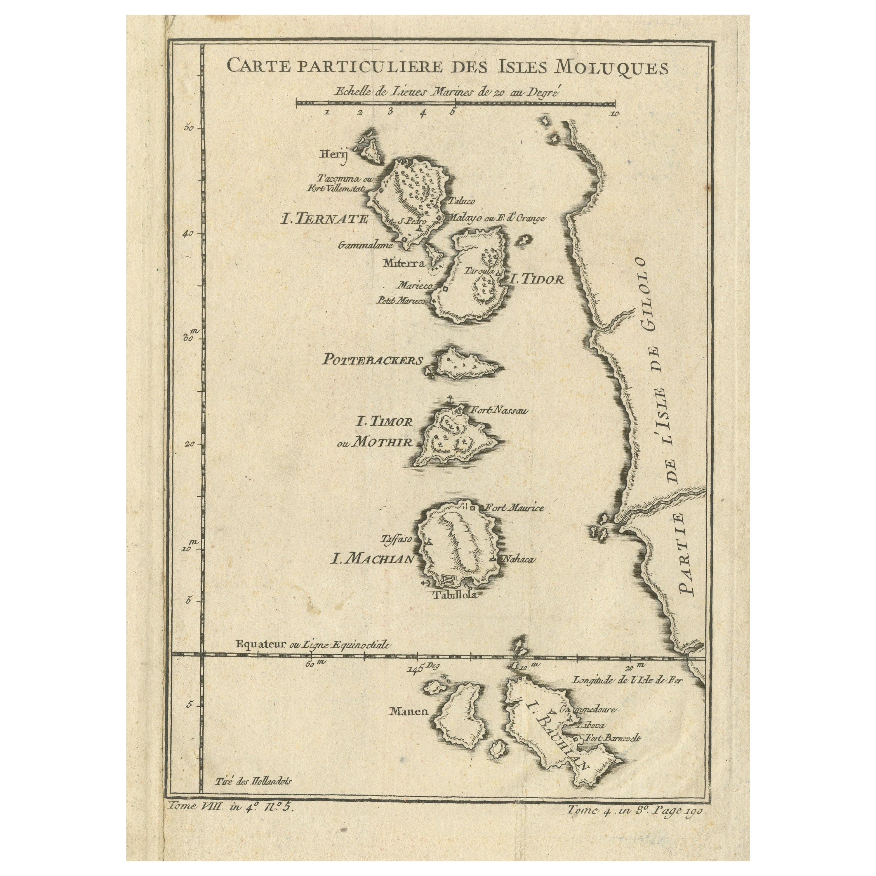
Antique Map of the Maluku Islands or Moluccas, Indonesia
Located in Langweer, NL
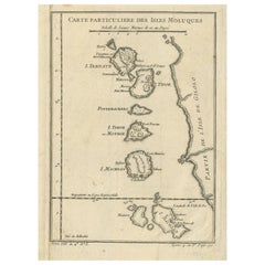
Antique map titled 'Carte Particuliere des Isles Moluques'. This map depicts the islands of Herij, Ternate, Tidor, Pottebackers, Timor, Machian and Bachian. The Moluccan islands were...
Category
Antique Mid-18th Century Maps
Materials
Paper
$144 Sale Price
20% Off
You May Also Like
Antique 1803 Italian Map of Asia Including China Indoneseia India
Located in Amsterdam, Noord Holland
Antique 1803 Italian Map of Asia Including China Indoneseia India
Very nice map of Asia. 1803.
Additional information:
Type: Map
Country of Manufacturing: Europe
Period: 19th centu...
Category
Antique 19th Century European Maps
Materials
Paper

$438 Sale Price
39% Off
Antique French Map of Asia Including China Indoneseia India, 1783
Located in Amsterdam, Noord Holland
Very nice map of Asia. 1783 Dedie au Roy.
Additional information:
Country of Manufacturing: Europe
Period: 18th century Qing (1661 - 1912)
Condition: Overall Condition B (Good Used)...
Category
Antique 18th Century European Maps
Materials
Paper

$486 Sale Price
40% Off
West Coast of Africa, Guinea
Sierra Leone: An 18th Century Map by Bellin
By Jacques-Nicolas Bellin
Located in Alamo, CA
Jacques Bellin's copper-plate map entitled "Partie de la Coste de Guinee Dupuis la Riviere de Sierra Leona Jusquau Cap das Palmas", depicting the coast of Guinea and Sierra Leone in ...
Category
Antique Mid-18th Century French Maps
Materials
Paper

$460 Sale Price
20% Off
Ancient Map - Zeilan - Etching by Johannes Janssonius - 1650s
By Johannes Janssonius
Located in Roma, IT
Ancient Map - Zeilan is an ancient map realized in 1650 by Johannes Janssonius (1588-1664).
The Map is Hand-colored etching, with coeval watercoloring.
...
Category
1650s Modern Figurative Prints
Materials
Etching

Original Antique Map of South East Asia by Thomas Clerk, 1817
Located in St Annes, Lancashire
Great map of South East Asia
Copper-plate engraving
Drawn and engraved by Thomas Clerk, Edinburgh.
Published by Mackenzie And Dent, 1817
Unframed.
Category
Antique 1810s English Maps
Materials
Paper

Antique Map - Mare Pacificum - Etching by Johannes Janssonius - 1650s
By Johannes Janssonius
Located in Roma, IT
Mare Pacificum is an antique map realized in 1650 by Johannes Janssonius (1588-1664).
The Map is Hand-colored etching, with coeval watercolorang.
Good conditions with slight foxing...
Category
1650s Modern Figurative Prints
Materials
Etching

More Ways To Browse
Antique Map Ceylon
Antique Map Of The Philippines
Antique Mississippi Map
Celestial Map
Map Of Middle East
17th Century American Furniture
Afghanistan Map
Antique Celestial Maps
Antique Maps Virginia
Hand Drawn Map
Map Of Israel
Map Of Poland
Sicily Map
Used Durham Furniture
Antique Maps Of Israel
Antique Maps Of Russian Empire
J C Walker Map
Massachusetts Antiques