Want more images or videos?
Request additional images or videos from the seller
1 of 5
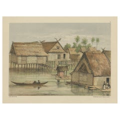
Antique Miniature Map of Borneo, incl Kalimantan, Indonesia, c.1610
$655.88List Price
About the Item
- Dimensions:Height: 10.24 in (26 cm)Width: 11.03 in (28 cm)Depth: 0 in (0.01 mm)
- Materials and Techniques:
- Period:
- Date of Manufacture:circa 1610
- Condition:
- Seller Location:Langweer, NL
- Reference Number:Seller: BG-119161stDibs: LU3054326085072
About the Seller
5.0
Recognized Seller
These prestigious sellers are industry leaders and represent the highest echelon for item quality and design.
Platinum Seller
Premium sellers with a 4.7+ rating and 24-hour response times
Established in 2009
1stDibs seller since 2017
2,826 sales on 1stDibs
Typical response time: 1 hour
Authenticity Guarantee
In the unlikely event there’s an issue with an item’s authenticity, contact us within 1 year for a full refund. DetailsMoney-Back Guarantee
If your item is not as described, is damaged in transit, or does not arrive, contact us within 7 days for a full refund. Details24-Hour Cancellation
You have a 24-hour grace period in which to reconsider your purchase, with no questions asked.Vetted Professional Sellers
Our world-class sellers must adhere to strict standards for service and quality, maintaining the integrity of our listings.Price-Match Guarantee
If you find that a seller listed the same item for a lower price elsewhere, we’ll match it.Trusted Global Delivery
Our best-in-class carrier network provides specialized shipping options worldwide, including custom delivery.You May Also Like
Antique Map of Principality of Monaco
By Antonio Vallardi Editore
Located in Alessandria, Piemonte
ST/619 - "Old Geographical Atlas of Italy - Topographic map of ex-Principality of Monaco" -
ediz Vallardi - Milano -
A somewhat special edition ---
Category
Antique Late 19th Century Italian Other Prints
Materials
Paper

Original Antique Map of Europe, Arrowsmith, 1820
Located in St Annes, Lancashire
Great map of Europe
Drawn under the direction of Arrowsmith.
Copper-plate engraving.
Published by Longman, Hurst, Rees, Orme and Brown, 1820
...
Category
Antique 1820s English Maps
Materials
Paper

Original Antique Map of Hungary, Arrowsmith, 1820
Located in St Annes, Lancashire
Great map of Hungary
Drawn under the direction of Arrowsmith.
Copper-plate engraving.
Published by Longman, Hurst, Rees, Orme and Brown, 1820
Unframed.
Category
Antique 1820s English Maps
Materials
Paper

Original Antique Map of Ireland- Kerry. C.1840
Located in St Annes, Lancashire
Great map of Kerry
Steel engraving
Drawn under the direction of A.Adlard
Published by How and Parsons, C.1840
Unframed.
Category
Antique 1840s English Maps
Materials
Paper

Original Antique Map of China, Arrowsmith, 1820
Located in St Annes, Lancashire
Great map of China
Drawn under the direction of Arrowsmith
Copper-plate engraving
Published by Longman, Hurst, Rees, Orme and Brown, 1820
Unfr...
Category
Antique 1820s English Maps
Materials
Paper

Original Antique Map of South America. C.1780
Located in St Annes, Lancashire
Great map of South America
Copper-plate engraving
Published C.1780
Two small worm holes to left side of map
Unframed.
Category
Antique Early 1800s English Georgian Maps
Materials
Paper

Original Antique Map of South Africa, Arrowsmith, 1820
Located in St Annes, Lancashire
Great map of South Africa.
Drawn under the direction of Arrowsmith.
Copper-plate engraving.
Published by Longman, Hurst, Rees, Orme and Br...
Category
Antique 1820s English Maps
Materials
Paper

Original Antique Map of Ancient Greece, Achaia, Corinth, 1786
Located in St Annes, Lancashire
Great map of Ancient Greece. Showing the region of Thessaly, including Mount Olympus
Drawn by J.D. Barbie Du Bocage
Copper plate engraving by P.F Tardieu
Original hand color...
Category
Antique 1780s French Other Maps
Materials
Paper

$35
Free Shipping
H 10 in W 14 in D 0.07 in
Original Antique Map of Ancient Greece- Boeotia, Thebes, 1787
Located in St Annes, Lancashire
Great map of Ancient Greece. Showing the region of Boeotia, including Thebes
Drawn by J.D. Barbie Du Bocage
Copper plate engraving by P.F T...
Category
Antique 1780s French Other Maps
Materials
Paper

$35
Free Shipping
H 10 in W 14 in D 0.07 in
Original Antique Map of Sweden, Engraved by Barlow, 1806
Located in St Annes, Lancashire
Great map of Sweden
Copper-plate engraving by Barlow
Published by Brightly & Kinnersly, Bungay, Suffolk. 1806
Unframed.
Category
Antique Early 1800s English Maps
Materials
Paper

More From This Seller
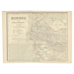
View AllAntique Map of West Kalimantan, Borneo, Indonesia, 1900
Located in Langweer, NL
Antique map titled 'Borneo en Belitoeng'. Old map of West Kalimantan, Borneo. This map originates from 'Atlas van Nederlandsch Oost- en West-Indië' by I. Dornseiffen.
Artists and...
Category
20th Century Maps
Materials
Paper
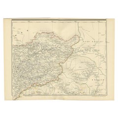
Antique Map of West Kalimantan (Schwaner Mountains), Borneo, Indonesia, 1900
Located in Langweer, NL
Antique map of West Kalimantan, Borneo. It shows the region of the Schwaner Mountains. This map originates from 'Atlas van Nederlandsch Oost- en West-Indië' by I. Dornseiffen.
Arti...
Category
20th Century Maps
Materials
Paper
$314 Sale Price
20% Off
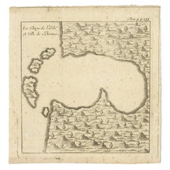
Antique Map of a Bay of Borneo, Indonesia, c.1760
Located in Langweer, NL
Antique map titled 'La Baye de l'isle et Ville de Borneo'. Small map depicting a Bay of Borneo.
Artists and Engravers: Anonymous.
Condition: Good, general age-related toning. Smal...
Category
Antique 18th Century Maps
Materials
Paper
Antique Map of Java and Part of Borneo, Indonesia, c.1657
Located in Langweer, NL
Antique map titled 'Insulae Iavae cum parte insularum Boreno Sumatrae (..)'.
Beautiful map of the island of Java and part of Borneo, Bali, Madura and Sumatra. With decorative carto...
Category
Antique 17th Century Maps
Materials
Paper

$2,623 Sale Price
20% Off
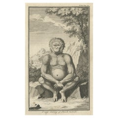
Engraving of an Orang-Utan on Borneo
Kalimantan
or Sumatra, Indonesia, 1739
Located in Langweer, NL
Antique print titled 'Orang-Oetang of Bosch-mensch'. This print depicts an Orang-Utan on Borneo or Sumatra, Indonesia. Originates from 'Hedendaagsche Historie, of tegenwoordige staat...
Category
Antique 1730s Prints
Materials
Paper
$133 Sale Price
20% Off
Print of Tenggarong in East-Kalimantan on The Island of Borneo, Indonesia, 1881
Located in Langweer, NL
Antique print with a view of Tenggarong, Indonesia. This print originates from 'Reis in Oost- en Zuid-Borneo van Koetei naar Banjermassin (..)' by Carl Bock....
Category
Antique 19th Century Prints
Materials
Paper
$228 Sale Price
20% Off
Still Thinking About These?
All Recently ViewedMore Ways To Browse
Biblical Maps
Maps Of Mediterranean
Treasure Map
Antique Navigational Tools
Mississippi Furniture
Caribbean Antiques
Antique Maps West Indies
Antique Mozambique
Malaysian Antique Furniture
Relief Map
Sur Tout
Antique Civil War Maps
Antique Nautical Maps
Civil War Map
Royal Stuart
Sri Lanka Map
Braun Artist
Hand Painted Antique Map