Items Similar to Antique Miniature Map of the Turkish Empire by Bertius
1618

Want more images or videos?
Request additional images or videos from the seller
1 of 9
Antique Miniature Map of the Turkish Empire by Bertius
1618
$675.56
$900.7525% Off
£500.42
£667.2225% Off
€562.50
€75025% Off
CA$924.34
CA$1,232.4525% Off
A$1,005.75
A$1,34125% Off
CHF 532.53
CHF 710.0425% Off
MX$12,099.85
MX$16,133.1425% Off
NOK 6,761.97
NOK 9,015.9625% Off
SEK 6,186.73
SEK 8,248.9725% Off
DKK 4,286.71
DKK 5,715.6125% Off
About the Item
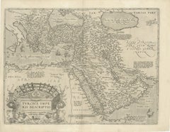
Antique miniature map titled 'Turcicum Imperium'. Rare miniature map of the Turkish Empire. This map originates from 'Tabularum Geographicarum Contractarum Libri septem (..)' by P. Bertius. Published by J. Hondius, 1618.
- Dimensions:Height: 4.93 in (12.5 cm)Width: 7.88 in (20 cm)Depth: 0.02 in (0.5 mm)
- Materials and Techniques:
- Place of Origin:
- Period:Early 17th Century
- Date of Manufacture:1618
- Condition:General age-related toning. Minor wear and creasing. Small worm trace below image. Latin text on verso. Please study image carefully.
- Seller Location:Langweer, NL
- Reference Number:Seller: BG-130021stDibs: LU3054324167272
About the Seller
5.0
Recognized Seller
These prestigious sellers are industry leaders and represent the highest echelon for item quality and design.
Platinum Seller
Premium sellers with a 4.7+ rating and 24-hour response times
Established in 2009
1stDibs seller since 2017
2,816 sales on 1stDibs
Typical response time: 1 hour
- ShippingRetrieving quote...Shipping from: Langweer, Netherlands
- Return Policy
More From This Seller
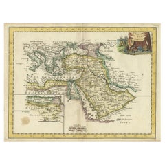
View AllAntique Map of the Turkish Empire by Tirion
c.1760
Located in Langweer, NL
Antique map titled 'Nieuwe Kaart van het Turksche Ryk gelegen in Europa, Asia en Africa'. Original antique map of the Turkish Empire. The map is centered on the Mediterranean Sea but...
Category
Antique Mid-18th Century Maps
Materials
Paper

$1,345 Sale Price
20% Off
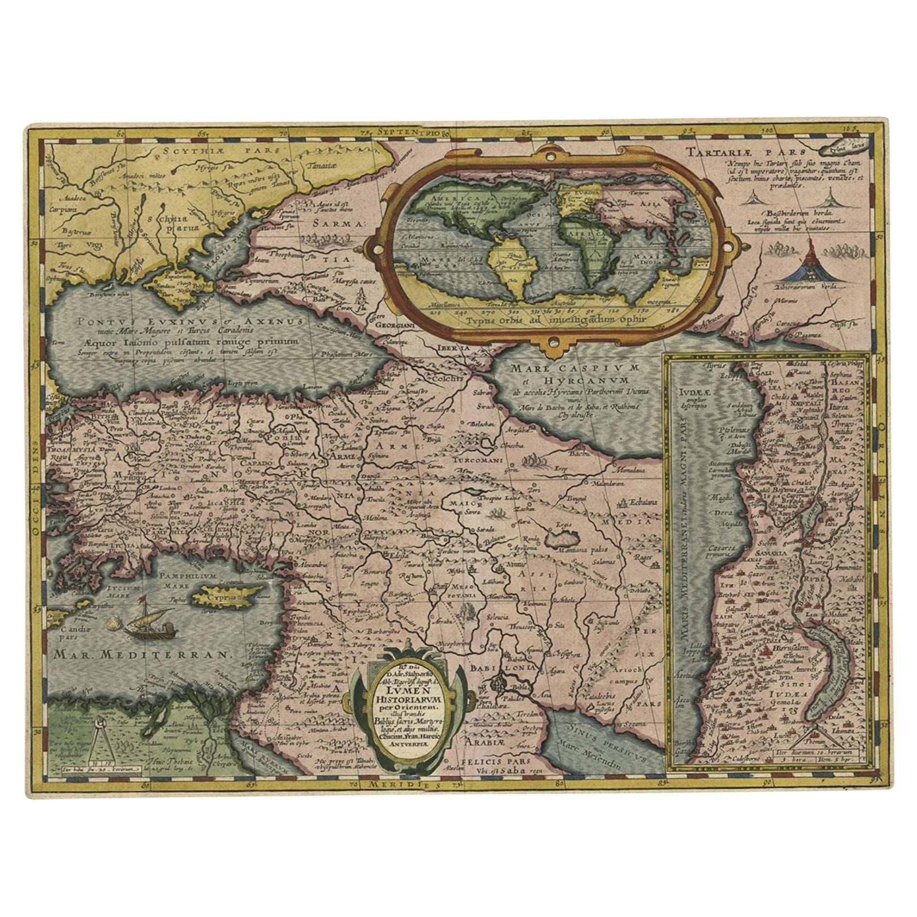
Scarce Antique Map of the Middle East, Surrounded by Latin Text, 1624
Located in Langweer, NL
Antique map titled 'Lumen Historium per Orientem (..).'
Scarce map of the Middle East, surrounded by Latin text. The two insets show Israel and an oval world map. This map (from the last edition of Ortelius Theatri Orbis Terrarum Parergon, 1624) was engraved by Franciscus Hareio. Later, this map was copied by Hornius for his World Atlas (1653).
Artists and Engravers: Franciscus Haraeus (Latinised form of Franciscus Verhaer; also known as Frans Verhaer), (Utrecht 1555? - Leuven, 11 January 1631), was a Dutch theologian, historian, and cartographer. He is best known for his history (from a Catholic point of view) of the Dutch Revolt...
Category
Antique 1620s Maps
Materials
Paper

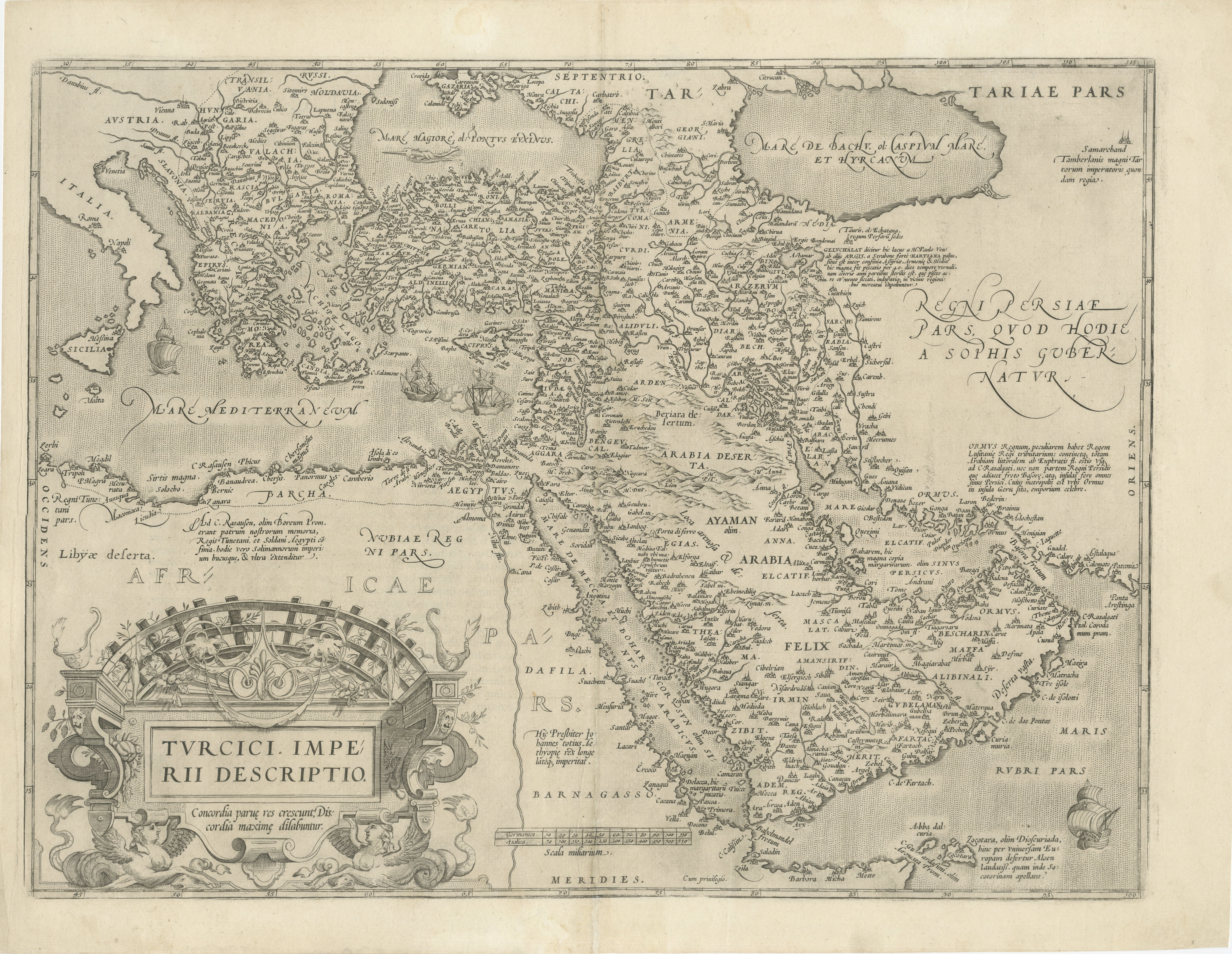
16th-Century Map of the Ottoman Empire and Near East: Turcici Imperii Descriptio
Located in Langweer, NL
Title: Original 16th-Century Map of the Ottoman Empire and Near East: *Turcici Imperii Descriptio* by Ortelius, 1571
This rare copperplate engraving, Turcici Imperii Descriptio, i...
Category
Antique 16th Century European Maps
Materials
Paper
$1,537 Sale Price
20% Off
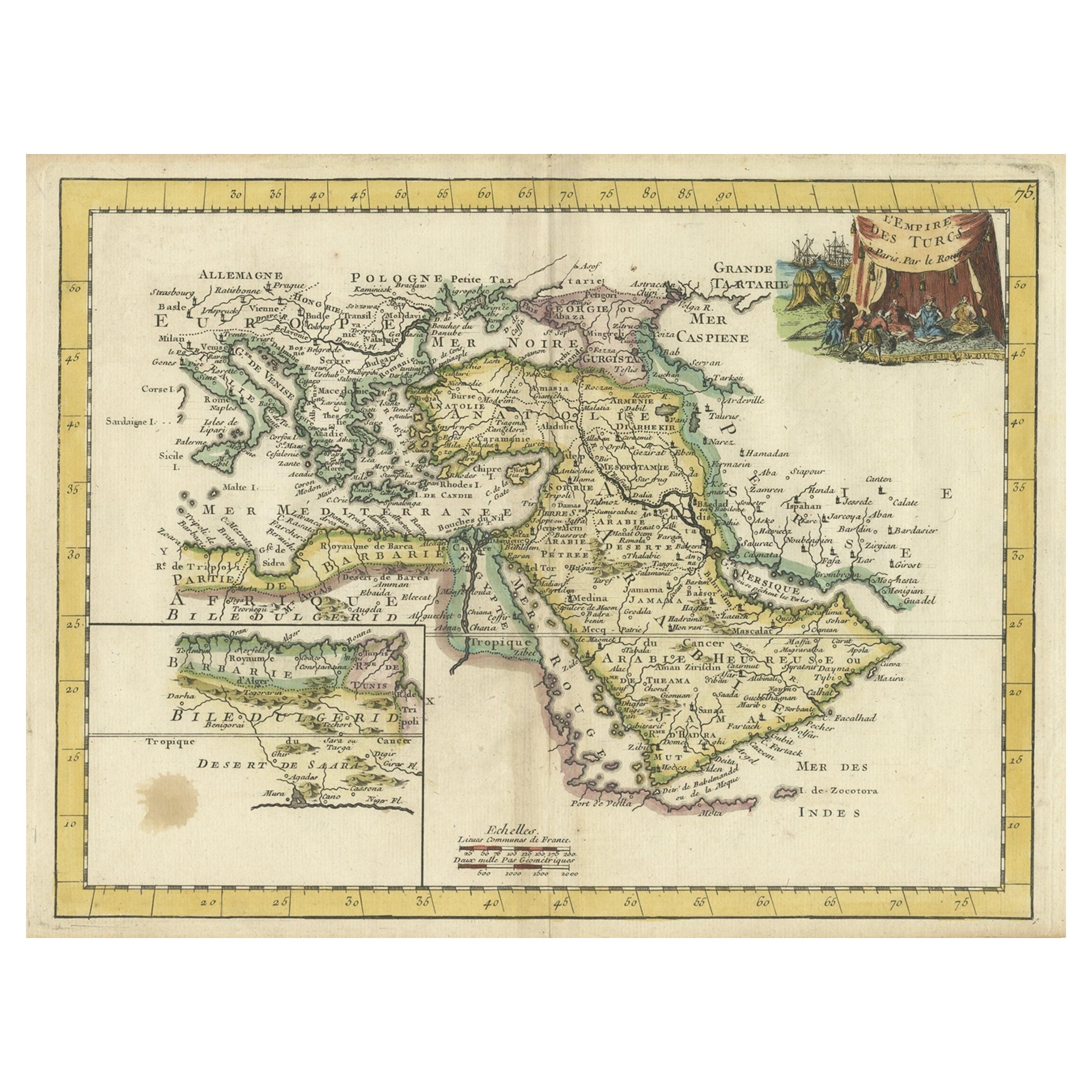
Orginal Antique Handcolored Map of the Turkish Empire, 1748
Located in Langweer, NL
Antique map titled 'L'Empire des Turcs'. Old map of the Turkish Empire with an inset of the North African regions. Originates from 'Atlas Nouveau Portatif' by G.L. le Rouge.
Artis...
Category
Antique 18th Century Maps
Materials
Paper
$343 Sale Price
35% Off
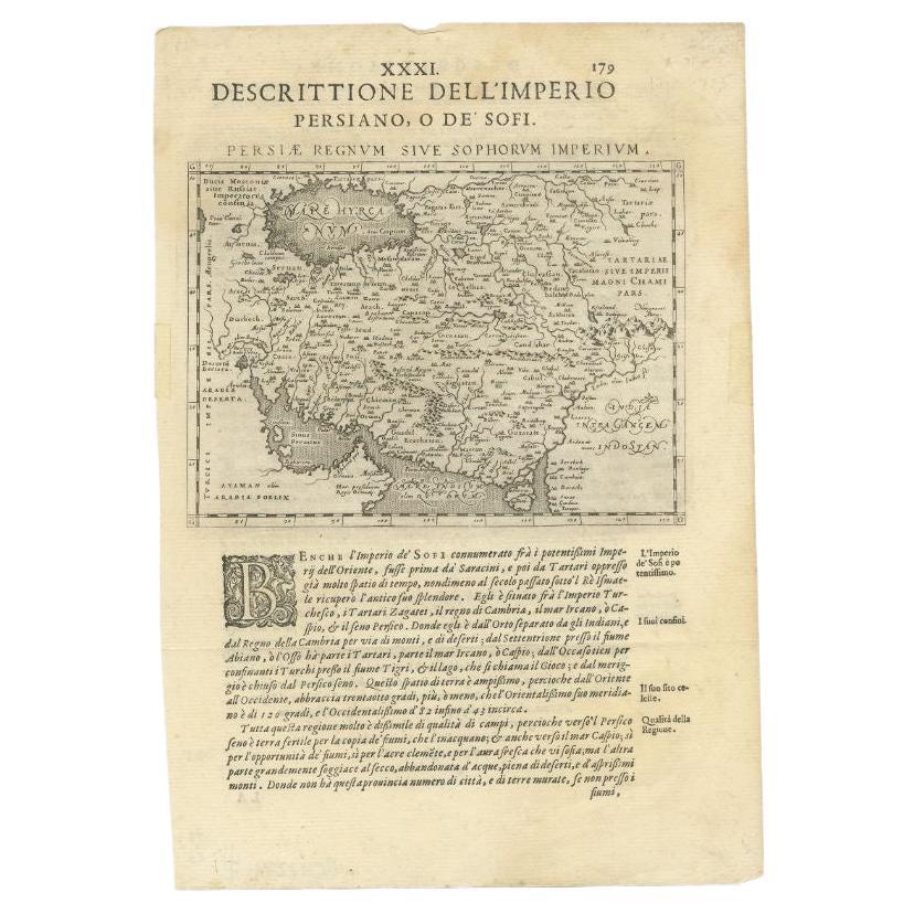
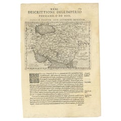
Very Old Antique Map of the Persian Empire by Magini, c.1597
Located in Langweer, NL
Antique map titled 'Persiae Regnum sive Sophorum Imperium'. Old map of the Persian Empire. This map originates from 'Geografia cioe Descrittione Universale della Terra' by G.A. Magin...
Category
Antique 16th Century Maps
Materials
Paper
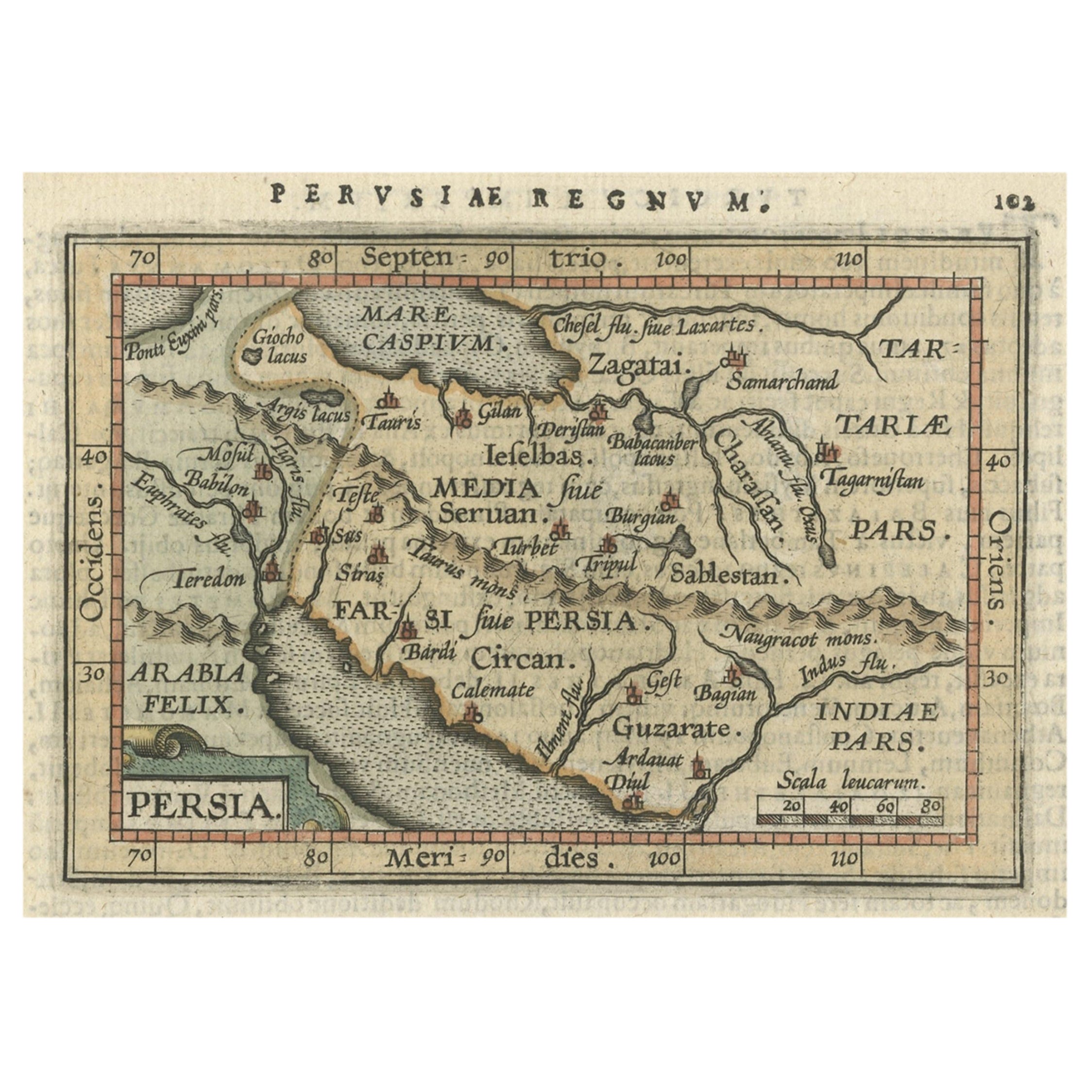
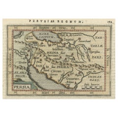
Original Antique Miniature Map of Persia, Published, ca.1601
Located in Langweer, NL
Antique miniature map titled 'Persia'. Small map of Persia published in the Epitome, or pocket-edition of the "Theatrum Orbis Terrarum".
Artists and e...
Category
Antique Early 1600s Maps
Materials
Paper
$518 Sale Price
20% Off
You May Also Like
"Nova Barbariae Descriptio", a 17th Century Hand-Colored Map of North Africa
By Johannes Janssonius
Located in Alamo, CA
This original attractive 17th century hand-colored map of North Africa entitled "Nova Barbariae Descriptio" by Johannes Janssonius was published in Paris in 1635. It includes the Med...
Category
Antique Mid-17th Century Dutch Maps
Materials
Paper

$1,020 Sale Price
20% Off
Persia, Armenia
Adjacent Regions: A 17th Century Hand-colored Map by De Wit
By Frederick de Wit
Located in Alamo, CA
A large 17th century hand colored copperplate engraved map entitled "Novissima nec non Perfectissima Scandinaviae Tabula comprehendens Regnorum Sueciae, Daniae et Norvegiae distincte...
Category
Antique Late 17th Century Dutch Maps
Materials
Paper

$1,500 Sale Price
20% Off
1718 Ides
Witsen Map "Route D
amsterdam a Moscow Et De La Ispahan Et Gamron
Located in Norton, MA
1718 Ides & Witsen map, entitled
"Route D'Amsterdam A Moscow Et De La Ispahan Et Gamron,"
Ric.b005
Subject: Eastern Europe and Central Asia
Period: 1718 (published)
Publicati...
Category
Antique Early 18th Century Dutch Maps
Materials
Paper

Southern
Eastern Europe: A Large 17th C. Hand-colored Map by Sanson
Jaillot
By Nicolas Sanson
Located in Alamo, CA
This large hand-colored map entitled "Estats de L'Empire des Turqs en Europe, ou sont les Beglerbeglicz our Gouvernements" was originally created by Nicholas Sanson d'Abbeville and t...
Category
Antique 1690s French Maps
Materials
Paper

$1,740 Sale Price
20% Off
Southern Greece: A Large 17th C. Hand-colored Map by Sanson and Jaillot
By Nicolas Sanson
Located in Alamo, CA
This large original hand-colored copperplate engraved map of southern Greece and the Pelopponese Peninsula entitled "La Moree Et Les Isles De Zante, Cefalonie, Ste. Marie, Cerigo & C...
Category
Antique 1690s French Maps
Materials
Paper

$1,580 Sale Price
20% Off
1592 Abraham Ortelius Map "Lorraine: Lotharingiae Nova Descripti, Ric.A005
Located in Norton, MA
1592 Abraham Ortelius map entitled
"Lorraine: Lotharingiae Nova Descripti
Ric.a005
Description: Ortelius is best known for producing the atlas from which this map comes from, "...
Category
Antique 16th Century Dutch Maps
Materials
Paper
