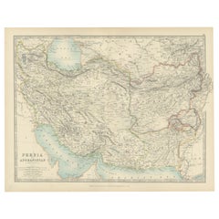
Items Similar to Antique Persia Map Wall Art – Iran Afghanistan Beluchistan, Rand McNally, c.1888


Want more images or videos?
Request additional images or videos from the seller
1 of 9
Antique Persia Map Wall Art – Iran Afghanistan Beluchistan, Rand McNally, c.1888
$463.61
£345.06
€390
CA$642.98
A$692.23
CHF 370.70
MX$8,341.07
NOK 4,677.21
SEK 4,280.40
DKK 2,972.52
About the Item
Antique Persia Map Wall Art – Iran Afghanistan Beluchistan, Rand McNally
Description:
This finely colored antique atlas map presents Persia (modern-day Iran), Afghanistan, and Beluchistan in a richly detailed yet visually balanced composition. Soft pastel color washes clearly define political boundaries, while dense engraved place names and subtle relief shading give the map depth and texture without visual heaviness. On the reverse a map of countries around the China Sea, like the Philippines, Hainan, Vietnam, Siam (Thailand), Malaysia, Singapore, Borneo, Sarawak, Cambodia and more.
Issued by Rand, McNally
Co. in the late 19th century, the map reflects the moment when modern scientific cartography met decorative atlas design. Persia occupies the central field, framed by the Caspian region to the north and the Indian frontier to the east, creating a strong and harmonious horizontal layout ideal for wall display.
The restrained palette—rose pinks, pale yellows, sage greens, and warm neutrals—makes this map particularly suitable for contemporary interiors. It reads as elegant wall art rather than a purely academic object, appealing to interior designers, collectors, and travelers alike.
Printed on original period atlas paper, the sheet retains the authentic surface and character expected of a genuine antique map. Once framed, it becomes a refined statement piece for a study, library, or living space.
Condition report: Light age toning consistent with age. Minor edge wear and gentle handling marks from original atlas binding. Overall clean and well preserved.
Framing tips: Excellent in a walnut, oak, or black frame with an ivory or light sand-colored mat. Museum glass recommended for clarity and protection.
Technique: Color lithograph
Maker: Rand, McNally
Co., United States, late 19th century
Keywords:
antique persia map, iran wall art, afghanistan antique map, beluchistan map, middle east map, antique atlas map, rand mcnally map, historical iran map, vintage geography print, decorative antique map, travel wall art, library decor
- Dimensions:Height: 10.44 in (26.5 cm)Width: 14.18 in (36 cm)Depth: 0.01 in (0.2 mm)
- Materials and Techniques:Paper,Engraved
- Place of Origin:
- Period:
- Date of Manufacture:1888
- Condition:Light age toning consistent with age. Minor edge wear and gentle handling marks from original atlas binding. Overall clean and well preserved.
- Seller Location:Langweer, NL
- Reference Number:Seller: BG-12794-701stDibs: LU3054348221442
About the Seller
5.0
Recognized Seller
These prestigious sellers are industry leaders and represent the highest echelon for item quality and design.
Platinum Seller
Premium sellers with a 4.7+ rating and 24-hour response times
Established in 2009
1stDibs seller since 2017
2,828 sales on 1stDibs
Typical response time: 1 hour
- ShippingRetrieving quote...Shipping from: Langweer, Netherlands
- Return Policy
More From This Seller
View AllAntique Map of Persia and Afghanistan, 1903, with Delicate Pastel Borders
Located in Langweer, NL
Title: Antique Map of Persia and Afghanistan, 1903, with Delicate Pastel Borders and Detailed Topography
Description:
This antique map, titled "Persia and Afghanistan," was engraved...
Category
Early 20th Century Maps
Materials
Paper
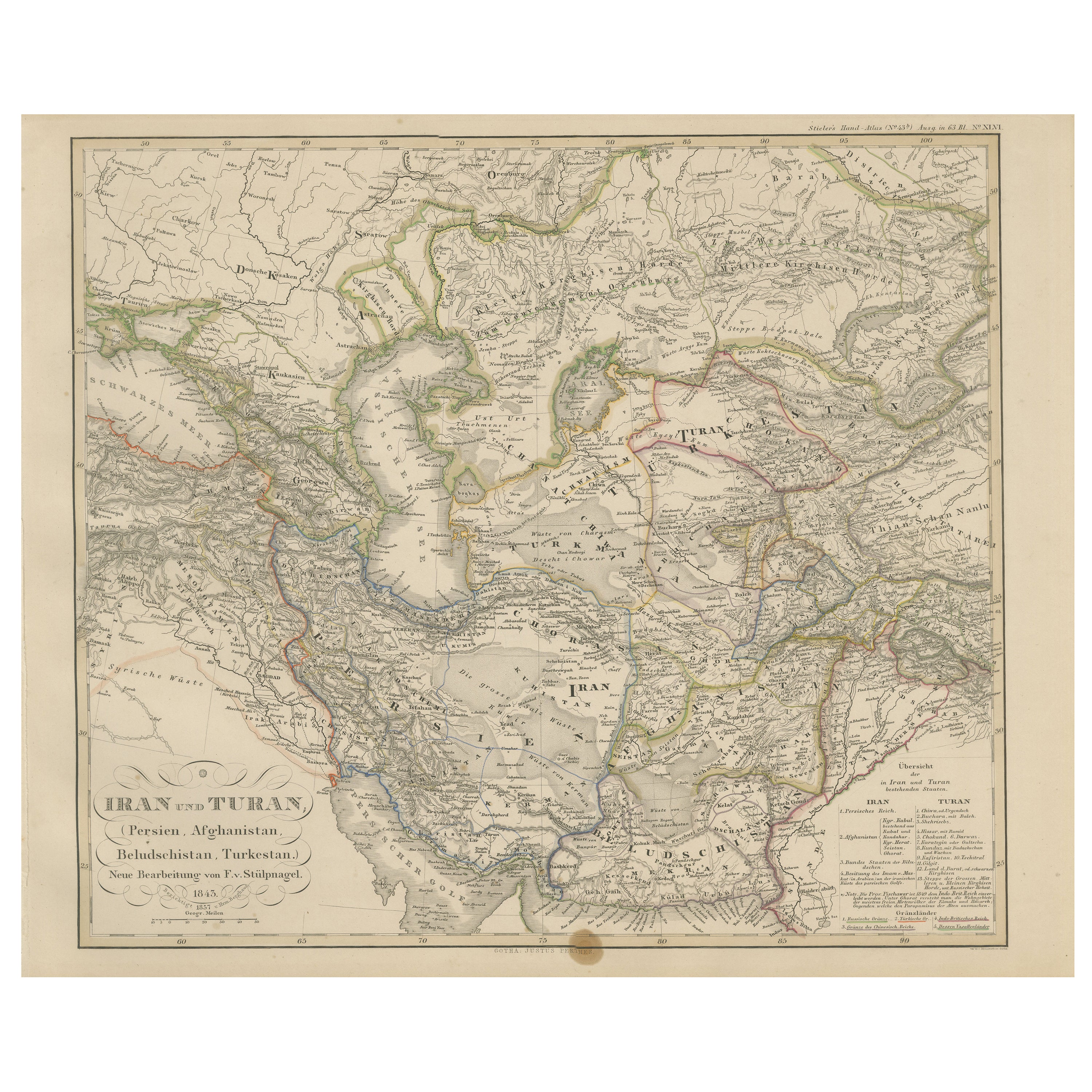
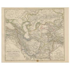
Iran and Turan Map – Persia, Afghanistan, Baluchistan, Turkestan 1858
Located in Langweer, NL
Iran and Turan Map – Persia, Afghanistan, Baluchistan, Turkestan 1858
This impressive antique print shows “Iran und Turan (Persien, Afghanistan, Beludschistan, Turkestan),” meaning ...
Category
Antique Mid-19th Century German Maps
Materials
Paper
Antique Map of Persia and Afghanistan by Johnston
1909
Located in Langweer, NL
Antique map titled 'Persia and Afghanistan'. Original antique map of Persia and Afghanistan. This map originates from the ‘Royal Atlas o...
Category
Early 20th Century Maps
Materials
Paper

$237 Sale Price
20% Off
Antique Map of Afghanistan and Surroundings,
1845
Located in Langweer, NL
Antique map titled 'Map of Persia and Caubul'. Original antique map of Afghanistan and surroundings.
This map originates from 'An Atlas of the World, Comprehending Separate Maps of...
Category
Antique Mid-19th Century Maps
Materials
Paper

$190 Sale Price
20% Off
Antique Map of Persia and Afghanistan by Johnston, 1882
Located in Langweer, NL
Antique map titled 'Persia and Afghanistan'.
Old map of Persia and Afghanistan. This map originates from 'The Royal Atlas of Modern Geography, Exhibiting, in a Series of Entirely O...
Category
Antique 19th Century Maps
Materials
Paper

Persia Unveiled: Antique Map of Iran, Afghanistan, and Beyond, 1852
Located in Langweer, NL
The antique map titled 'Royaumes de Perse Herat & Kaboul' is an attractive map of Persia. Here are the key details and features of the map:
1. **Geographic Coverage**:
- The map ...
Category
Antique Mid-19th Century French Maps
Materials
Paper

$152 Sale Price
20% Off
You May Also Like
Map of Persia - Original Etching - Late 19th Century
Located in Roma, IT
This Map of Persia is an etching realized by an anonymous artist.
The state of preservation of the artwork is good with some small diffused stains.
Sheet dimension: 25.5 x 44
At t...
Category
Late 19th Century Modern Figurative Prints
Materials
Etching
Large Original Vintage Map of Persia / Iran, circa 1920
Located in St Annes, Lancashire
Great maps of Persia.
Unframed.
Original color.
By John Bartholomew and Co. Edinburgh Geographical Institute.
Published, circa 1920.
Free shipping.
Category
Vintage 1920s British Maps
Materials
Paper

Large Original Antique Map of Afghanistan. Edward Weller, 1861
Located in St Annes, Lancashire
Great map of Afghanistan
Lithograph engraving by Edward Weller
Original colour
Published, 1861
Unframed
Good condition
Category
Antique 1860s English Victorian Maps
Materials
Paper

Persia, Armenia
Adjacent Regions: A 17th Century Hand-colored Map by De Wit
By Frederick de Wit
Located in Alamo, CA
A large 17th century hand colored copperplate engraved map entitled "Novissima nec non Perfectissima Scandinaviae Tabula comprehendens Regnorum Sueciae, Daniae et Norvegiae distincte...
Category
Antique Late 17th Century Dutch Maps
Materials
Paper

Persia
Afghanistan: A Framed Hand-colored 17th Century Map by John Cary
By John Cary
Located in Alamo, CA
This colorful and detailed early 18th century copperplate map by John Cary entitled "A New Map of Persia from the Latest Authorities" was published in London in 1801. It depicts Persia, the region of modern day Afghanistan, the Caspian Sea, the Sea of Aral, the Persian Gulf...
Category
Early 19th Century Old Masters More Prints
Materials
Engraving

Large Original Antique Map of Morocco. Edward Weller, 1861
Located in St Annes, Lancashire
Great map of Morocco
Lithograph engraving by Edward Weller
Original colour
Published, 1861
Unframed
Good condition.
Category
Antique 1860s English Victorian Maps
Materials
Paper
