Items Similar to Antique Plan of Port-Vendres, Roussillon, France
Want more images or videos?
Request additional images or videos from the seller
1 of 6
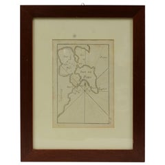
Antique Plan of Port-Vendres, Roussillon, France
$325.49
$406.8620% Off
£243.10
£303.8820% Off
€272
€34020% Off
CA$448.42
CA$560.5220% Off
A$488.70
A$610.8720% Off
CHF 258.79
CHF 323.4820% Off
MX$5,869.76
MX$7,337.1920% Off
NOK 3,276.28
NOK 4,095.3620% Off
SEK 3,012.22
SEK 3,765.2820% Off
DKK 2,072.17
DKK 2,590.2120% Off
About the Item
Antique map titled 'Plan de Port Vendre en Roussillon'. Original plan of Port-Vendres, Roussillon, France. This map originates from 'Le Petit Atlas Maritime (..)' by J.N. Bellin. Published 1764.
Bellin was an important maker of charts for the French Depot de la Marine. He was born in Paris in 1703 and educated as an engineer. He produced many important charts and published them individually and in compilations. The Neptune Francais was published in 1753 and the Hydrographie Francaise in 1756. His largest and most comprehensive work is the Petit Atlas Maritime.
- Dimensions:Height: 12.49 in (31.7 cm)Width: 8.98 in (22.8 cm)Depth: 0.02 in (0.5 mm)
- Materials and Techniques:
- Period:
- Date of Manufacture:1764
- Condition:General age-related toning. Light creasing. Minor wear and soiling, blank verso. Please study image carefully.
- Seller Location:Langweer, NL
- Reference Number:Seller: BG-13397-41stDibs: LU3054333644802
About the Seller
5.0
Recognized Seller
These prestigious sellers are industry leaders and represent the highest echelon for item quality and design.
Platinum Seller
Premium sellers with a 4.7+ rating and 24-hour response times
Established in 2009
1stDibs seller since 2017
2,788 sales on 1stDibs
Typical response time: <1 hour
- ShippingRetrieving quote...Shipping from: Langweer, Netherlands
- Return Policy
More From This Seller
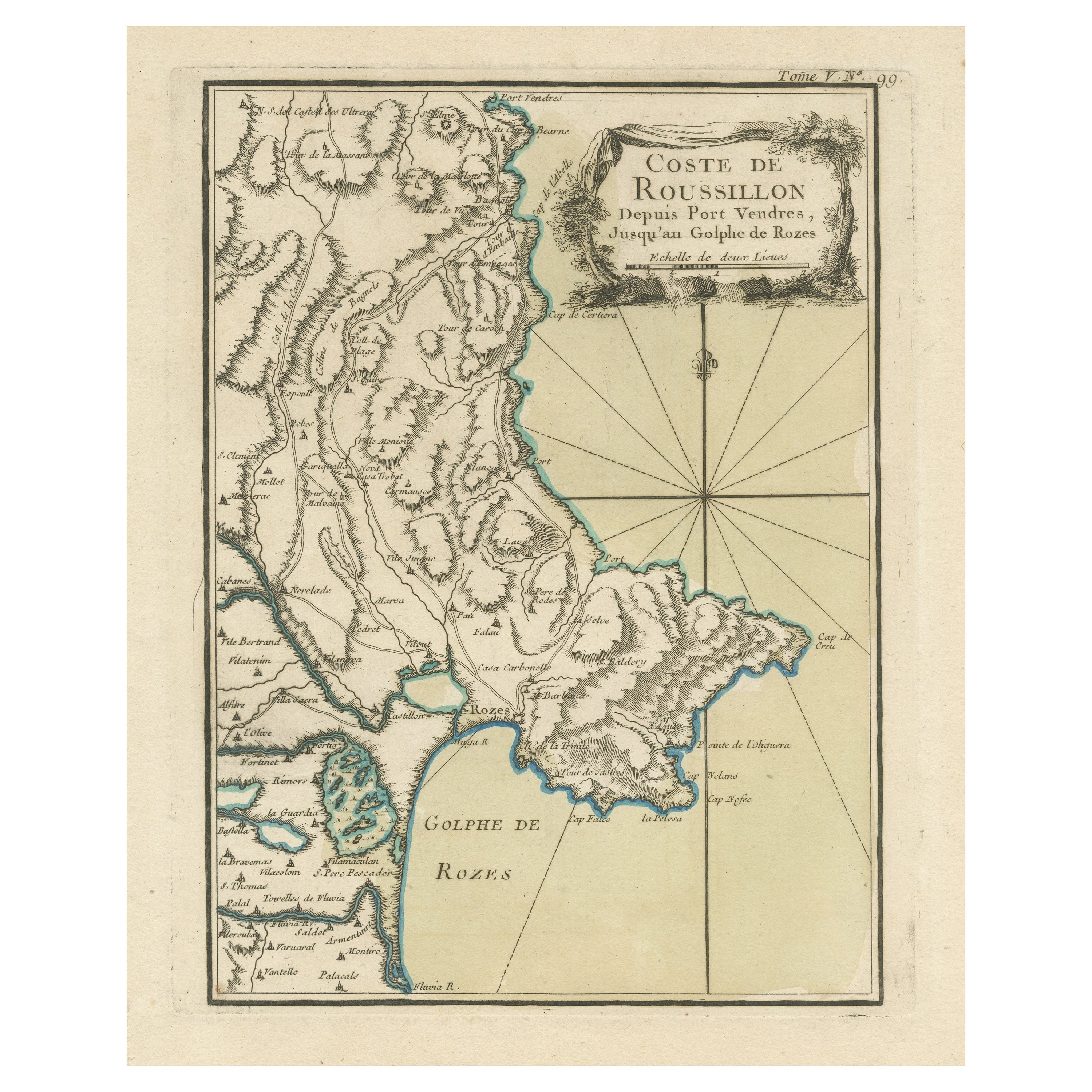
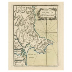
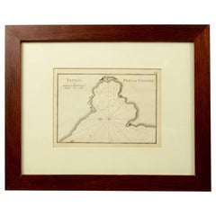
View AllAntique Map of the Coast of Roussillon, France
Located in Langweer, NL
Antique map titled 'Coste de Roussillon depuis Port Vendres, jusqu'au golphe de Rozes'. Original map of the coast of Roussillon, France. This map originates from 'Le Petit Atlas Mari...
Category
Antique Mid-18th Century Maps
Materials
Paper
$325 Sale Price
20% Off
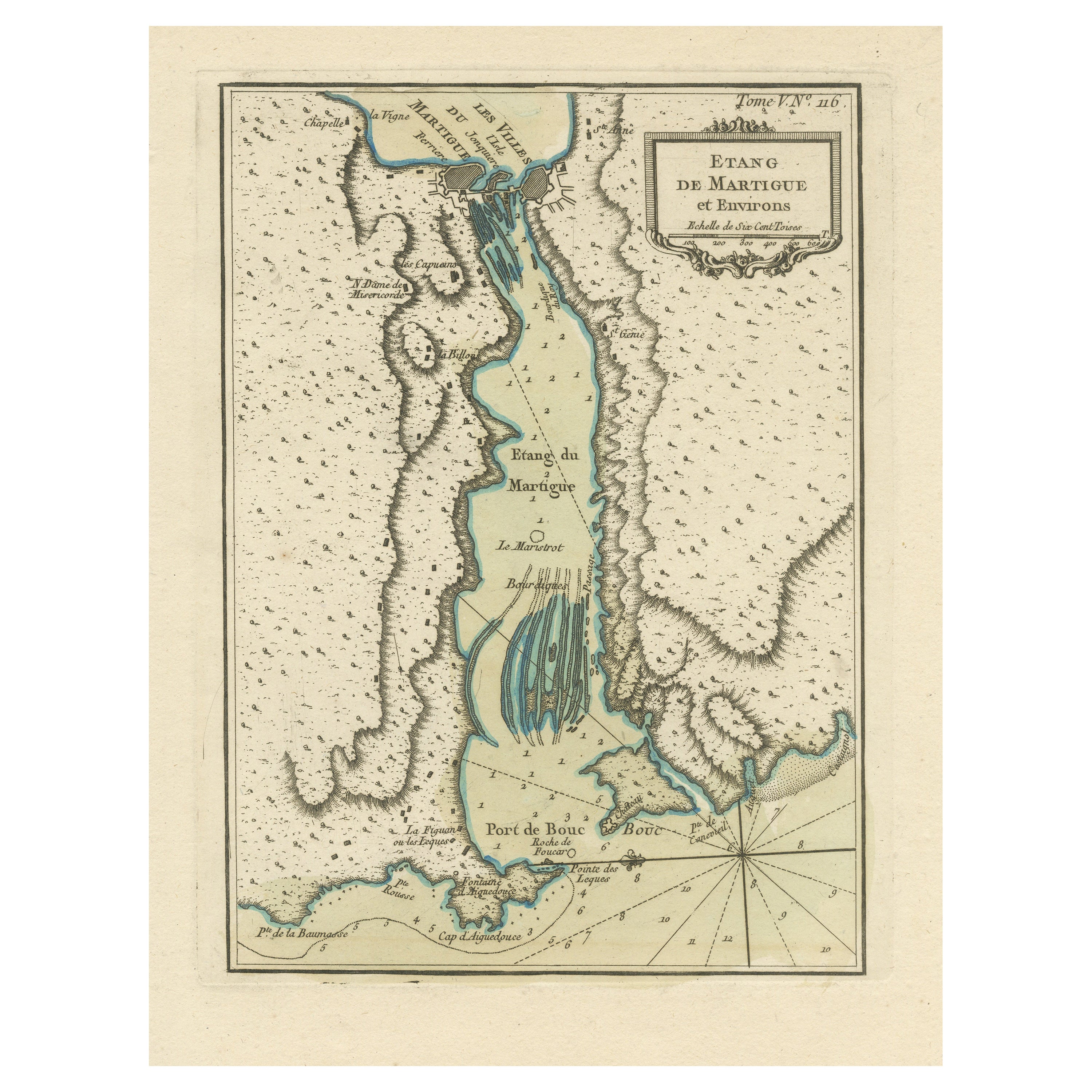
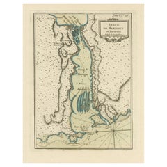
Antique Map of the Region of Martigues, France
Located in Langweer, NL
Title: "Etang de Martigues et Environs: Antique Map of the Martigues Region, France"
Description: This antique map, titled "Etang de Martigue et Environs," offers a detailed view of...
Category
Antique Mid-18th Century Maps
Materials
Paper
$325 Sale Price
20% Off
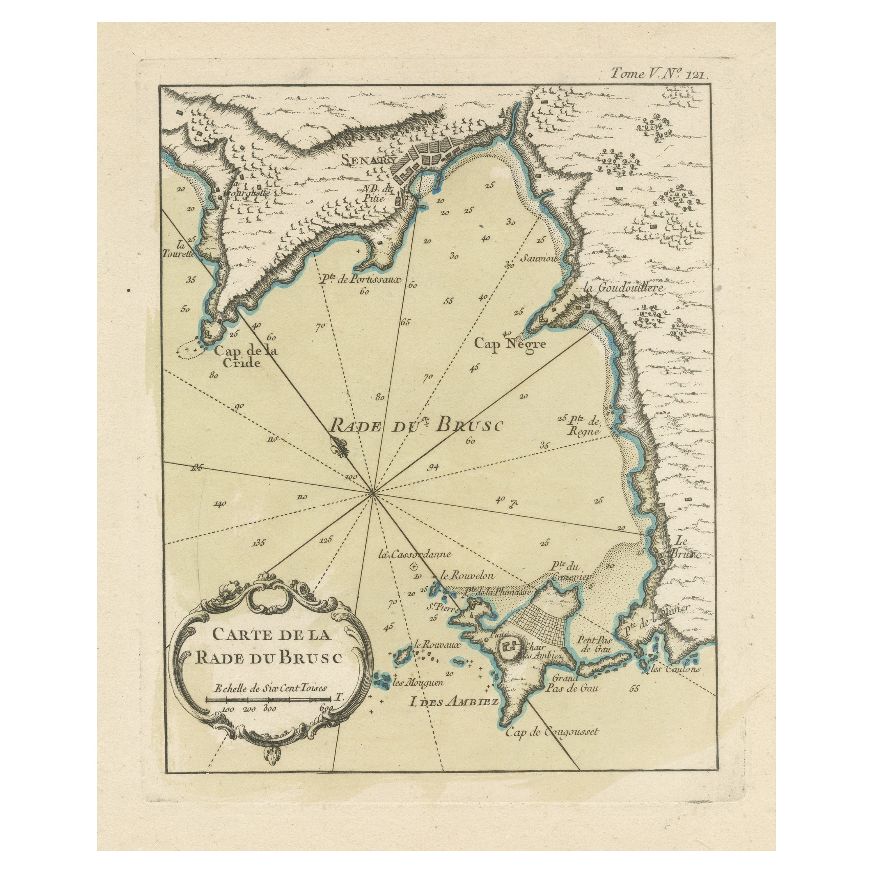
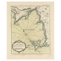
Antique Map of the Bay of Brusc, France
Located in Langweer, NL
Antique map titled 'Carte de la rade du Brusc'. Original map of the bay of Brusc, France. This map originates from 'Le Petit Atlas Maritime (..)' by J.N. Bellin. Published 1764.
...
Category
Antique Mid-18th Century Maps
Materials
Paper
$325 Sale Price
20% Off
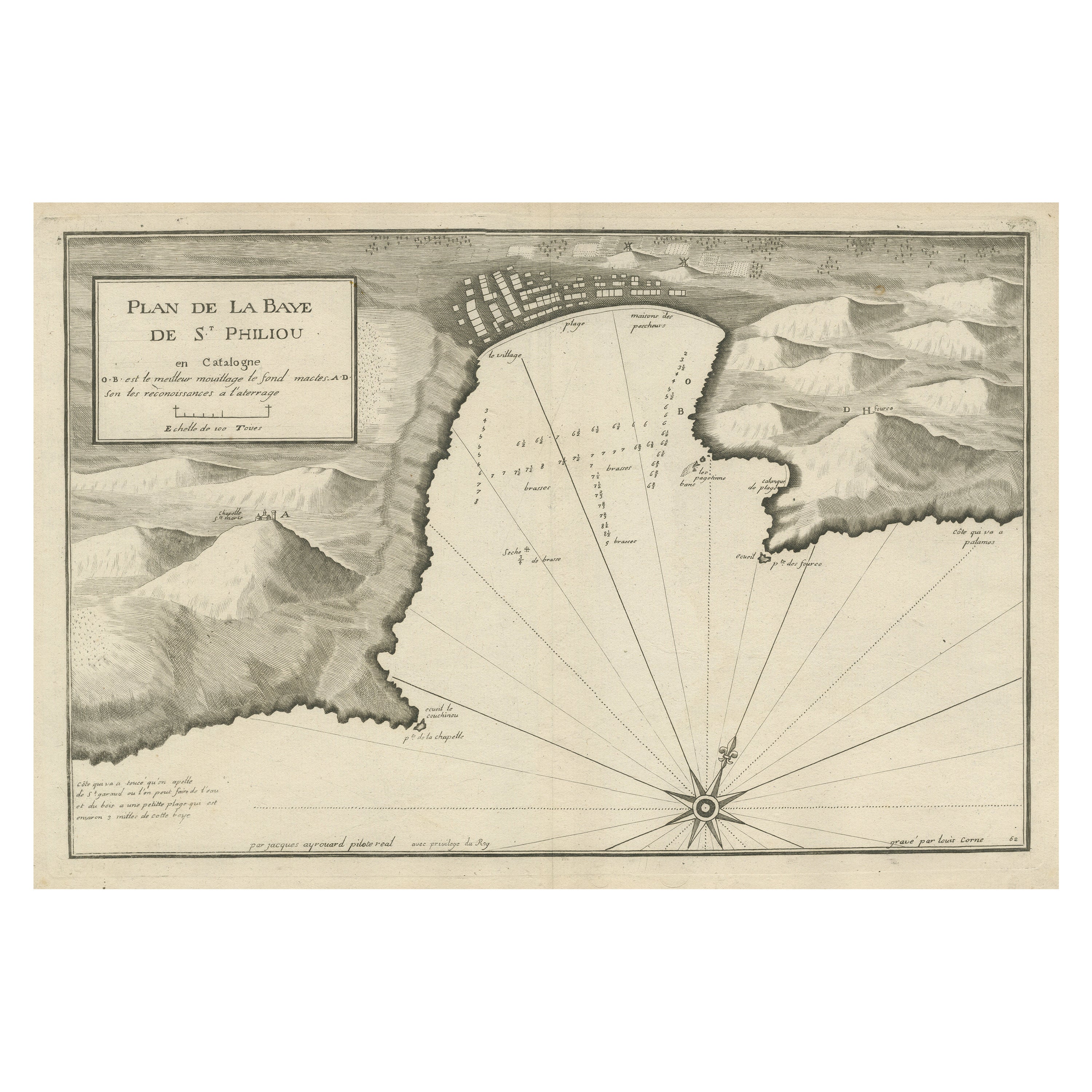
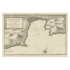
Large Antique Plan of St. Philiou Bay or Sant Feliu Catalonia Spain, circa 1746
Located in Langweer, NL
This antique map is a black and white harbor chart, specifically a port plan of St. Philiou, which is likely associated with Sant Feliu, Spain. This historical cartographic piece ori...
Category
Antique Mid-18th Century Maps
Materials
Paper
$516 Sale Price
20% Off
Free Shipping
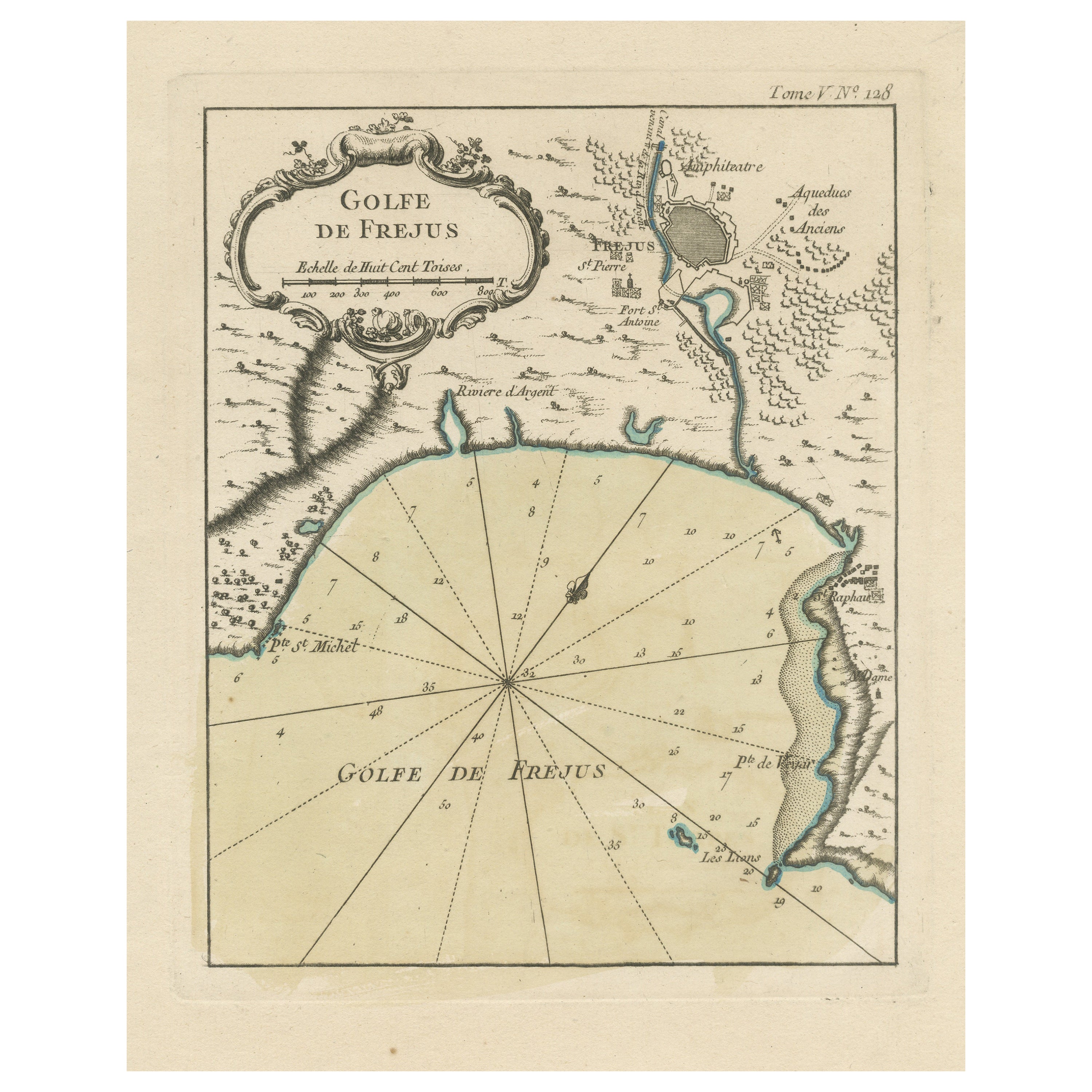
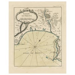
Antique Map of the Region of Fréjus, France
Located in Langweer, NL
Title: "Golf de Fréjus"
Description: This antique map, titled "Golf de Fréjus," is an original depiction of the region of Fréjus, France. It is part of the work "Le Petit Atlas Mari...
Category
Antique Mid-18th Century Maps
Materials
Paper
$284 Sale Price
30% Off
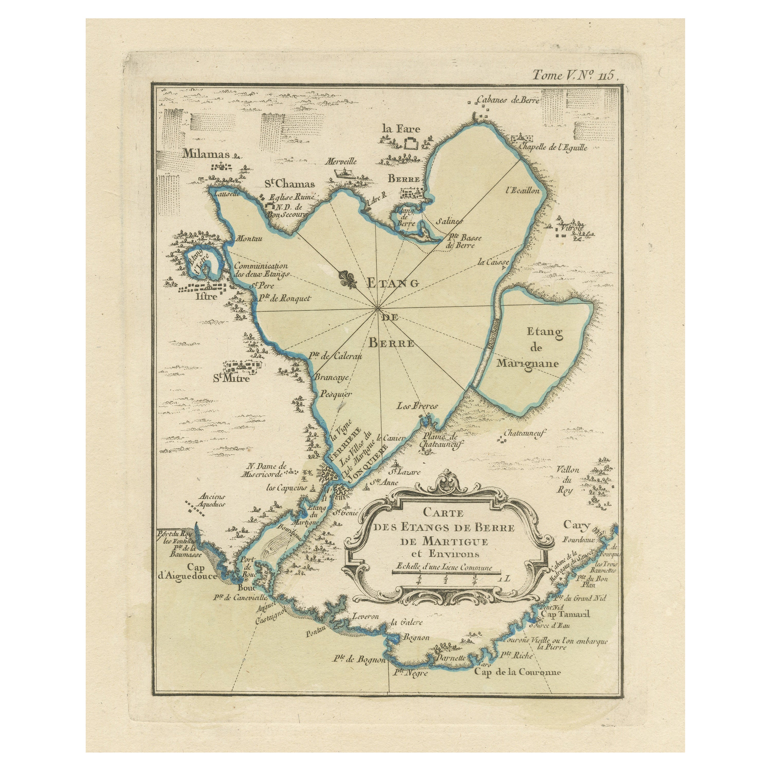
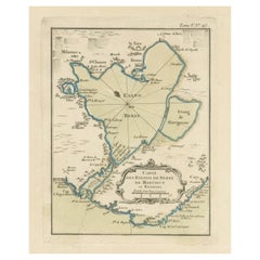
Antique Map of the Region of Berre-l
Étang, France
Located in Langweer, NL
Antique map titled 'Carte des etangs de Berre de Martigue et environs'. Original map of the region of Berre-l'Étang, France. This map originates from 'Le Petit Atlas Maritime (..)' b...
Category
Antique Mid-18th Century Maps
Materials
Paper
$325 Sale Price
20% Off
You May Also Like
1844 French Antique Nautical Portolan of Plan du Port de Cherfe by Antoine Roux
By Antoine Roux
Located in Milan, IT
Antique portolano, nautical map of Plan du Port de Cherfe engraved on a copper plate by Antoine Roux, Marseille France 1844, from his work Recueil des principaux plans des ports et d...
Category
Antique 1840s French Nautical Objects
Materials
Paper

Plan of Port Siagi - Etching by Joseph Roux - 1795
Located in Roma, IT
Plan of Port Siagi is al colored etching realized by Joseph Roux in 1795.
The title at the top " Plan du Port Siagi"
Passepartout included: 34 x 49
The artwork is hand water-color...
Category
1790s Modern Figurative Prints
Materials
Etching

Map of Vendée - Etching - 19th Century
Located in Roma, IT
Map of Vendée is an etching realized by an anonymous engraver of the 19t century.
Printed in series of "France Pittoresque" at the top center.
The state of preservation of the artw...
Category
19th Century Modern Figurative Prints
Materials
Etching

Original Antique Map or City Plan of Geneva, Switzerland. Circa 1835
Located in St Annes, Lancashire
Nice map of Geneva
Drawn and engraved by J.Dower
Published by Orr & Smith. C.1835
Unframed.
Free shipping
Category
Antique 1830s English Maps
Materials
Paper

Antique Nautical Portolano of Isle De Poro by Antoine Roux, France, 1844
By Antoine Roux
Located in Milan, IT
Antique portolano, nautical map of Isle De Poro engraved on a copper plate by Antoine Roux, Marseille France 1844, from his work Recueil des principaux plans des ports et de Rades de...
Category
Antique 1840s French Nautical Objects
Materials
Paper
1844 French Nautical Portolano of Port De Chichimé Natolie by Antoine Roux
By Antoine Roux
Located in Milan, IT
Antique portolano, nautical map of Port De Chichimé Natolie engraved on a copper plate by Antoine Roux, Marseille France 1844, from his work Recueil des principaux plans des ports et...
Category
Antique 1840s French Nautical Objects
Materials
Paper
More Ways To Browse
Washington Dc Map
Wood Carved Golfer
1681 Moses Pitt
Antique Map Bermuda
Antique Map Of Brooklyn
Antique Map Of Republic Of Texas
Extra Large Map
George Weymouth
Georgetown Map
Hemisphere Antiques
J Matthews
Japanese Kite
Maltese Falcon
Map Tuscany
St Eustatius
Sumba Map
Used Furniture Denver Co
Used Furniture Leominster