Items Similar to Antique Road Map, London to Hythe, Kent, English, Cartography, John Ogilby, 1675

Want more images or videos?
Request additional images or videos from the seller
1 of 13
Antique Road Map, London to Hythe, Kent, English, Cartography, John Ogilby, 1675
$1,398.42
£1,016
€1,188.70
CA$1,911.24
A$2,080.54
CHF 1,104.35
MX$25,033.32
NOK 13,993.61
SEK 12,822.10
DKK 8,877.16
About the Item
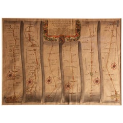
This is an antique Road Map from London to Hythe, Kent. An English, cartographic atlas excerpt by John Ogilby, dating to the late 17th century with later frame, circa 1675
A superb example of early English road cartography, this antique atlas excerpt by John Ogilby depicts the historic route from London to Hythe, Kent. Beautifully preserved and presented within a later glazed frame, this piece embodies the craftsmanship and innovation of Britain’s first road atlas annotated in miles.
Fascinating coaching road map, compiled by John Ogilby and published in 1675 within the monochrome Itinerarium Angliæ
Skilfully engraved across six vertical panels from London (bottom left) to Hythe (top right)
Ornate title panel embellished with decorative frieze and cartouche detailing
Ogilby’s pioneering trundle wheel method mapped the route at 1 inch to the mile scale
Displays a pleasing aged patina, the engraving clear and legible throughout
Set behind clear glass within a tasteful later frame, complementing the map’s antiquity
Dressed to the rear with hanging loop for ease of wall mounting
A fine example of Restoration-era road mapping, combining historical interest and decorative appeal
This is a quality antique road map of London to Hythe, offering remarkable cartographic charm and ready for elegant display in any collection or period setting. Delivered ready to display.
Dimensions:
Max Width: 48.5cm (19'')
Max Depth: 2.5cm (1'')
Max Height: 40cm (15.75'')
Map Width: 46.5cm (18.25'')
Map Height: 37.5cm (14.75'')
- Dimensions:Height: 15.75 in (40 cm)Width: 19.1 in (48.5 cm)Depth: 0.99 in (2.5 cm)
- Style:Queen Anne (Of the Period)
- Materials and Techniques:
- Place of Origin:
- Period:
- Date of Manufacture:Circa 1675
- Condition:Wear consistent with age and use. Presented in good antique condition.
- Seller Location:Hele, Devon, GB
- Reference Number:Seller: 255571stDibs: LU2645347303242
About the Seller
5.0
Platinum Seller
Premium sellers with a 4.7+ rating and 24-hour response times
Established in 2005
1stDibs seller since 2017
1,088 sales on 1stDibs
Typical response time: <1 hour
- ShippingRetrieving quote...Shipping from: Hele, Devon, United Kingdom
- Return Policy
More From This Seller
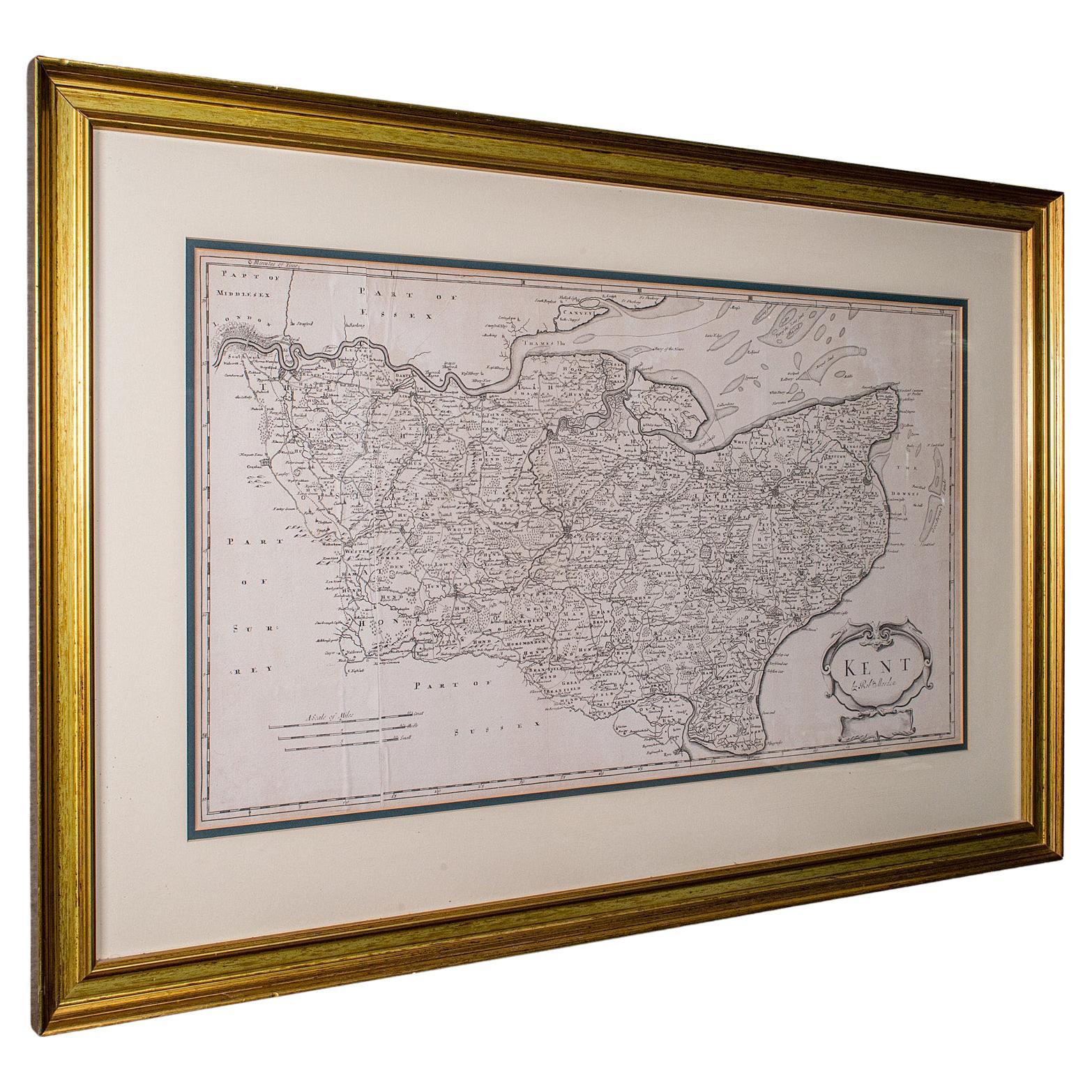
View AllLarge Antique Lithography Map of Kent, English, Cartography, Robert Morden, 1700
Located in Hele, Devon, GB
This is a large antique lithography map of Kent. An English, framed atlas engraving of cartographic interest by Robert Morden, dating to the early 18th century and later.
Superb li...
Category
Antique Early 18th Century British Queen Anne Maps
Materials
Glass, Wood, Paper

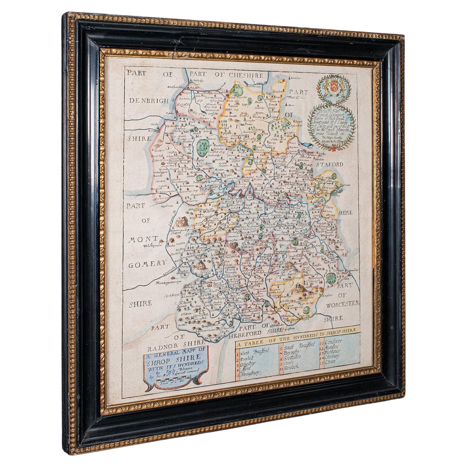
Antique County Map, Shropshire, English, Atlas Engraving, Richard Blome, C.1673
Located in Hele, Devon, GB
This is an antique county map of Shropshire. An English, framed atlas engraving by Richard Blome, dating to the 17th century and later.
A treat for the collector or county native, ...
Category
Antique 17th Century British Restauration Maps
Materials
Glass, Wood, Paper

Antique County Map of Cheshire, Dutch, Framed, Cartography, Janssonius, C.1660
Located in Hele, Devon, GB
This is an antique county map of Cheshire. A Dutch, framed atlas engraving by Johannes Janssonius, dating to the 17th century and later.
A treat for the collector or county native,...
Category
Antique Mid-17th Century Dutch Charles II Maps
Materials
Glass, Wood, Paper

Antique County Map, Hampshire, English, Framed Cartography, Robert Morden, 1700
Located in Hele, Devon, GB
This is an antique county map of Hampshire. An English, framed atlas engraving of cartographic interest By Robert Morden, dating to the late 17th century and later.
Superb lithogra...
Category
Antique Late 17th Century British Other Maps
Materials
Glass, Wood, Paper

Antique County Map, Middlesex, English, Framed, Litho, Cartography, Victorian
Located in Hele, Devon, GB
This is an antique lithography map of Middlesex. An English, framed atlas engraving of cartographic interest, dating to the mid 19th century and later.
Superb lithography of Middle...
Category
Antique Mid-19th Century British Victorian Maps
Materials
Paper
Antique Lincolnshire Map, English, County Cartography, Robert Morden, Victorian
Located in Hele, Devon, GB
This is a fine antique county map of Lincolnshire. An English, framed reproduction engraving, dating to the Victorian period and later, circa 1900.
A superb cartographic reproducti...
Category
Early 20th Century British Queen Anne Maps
Materials
Glass, Paper
You May Also Like
Antique Map of Essex by Overton, circa 1710
Located in Langweer, NL
Antique map titled 'Essex, devided into Hundreds, with the most antient and fayre Towne Colchester (..)'. Map of Essex, England. Includes an inset town pl...
Category
Antique Early 18th Century Maps
Materials
Paper

$911 Sale Price
20% Off
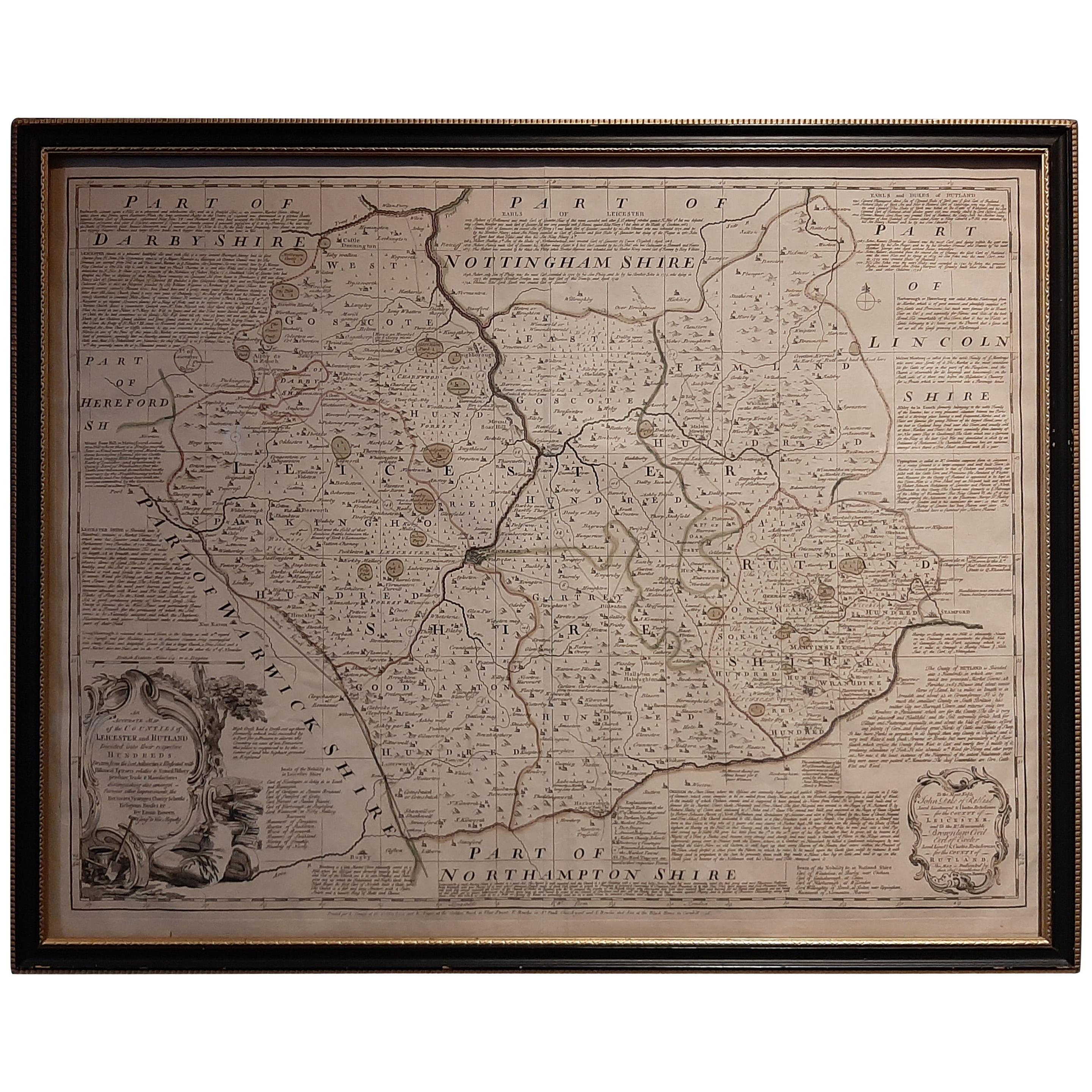
Antique Map of Leicester and Rutland by Tinney
Sayer,
circa 1756
Located in Langweer, NL
Antique map titled 'An Accurate Map of the Counties of Leicester and Rutland (..)'. Large map of Leicester and Rutland with dedications to the Most Noble John Duke of Rutland, and to...
Category
Antique Mid-18th Century Maps
Materials
Paper

$767 Sale Price
20% Off
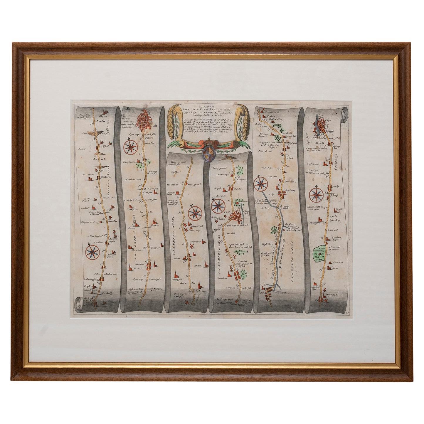
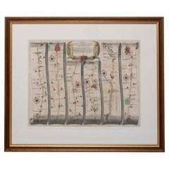
Road Map No43 London to Kings Lynn, Royston to Downham, John Ogilby, Britannia
By John Ogilby
Located in BUNGAY, SUFFOLK
John Ogilby (British 1600-1676) Cosmographer and Geographick Printer to Charles II.
A road map from Britannia, 1675/6. The road from London to Kings Lynn, showing Royston to Downham. In oak and gilded frame.
In a remarkable life John Ogilby pursued, several careers, each ending in misfortune, and yet he always emerged undeterred, to carry on. His modern reputation is based on his final career, started in his sixty-sixth year, as a publisher of maps and geographical accounts.
Ogilby was born outside Dundee, in 1600, the son of a Scottish gentleman...
Category
Antique Late 17th Century British Charles II Maps
Materials
Paper
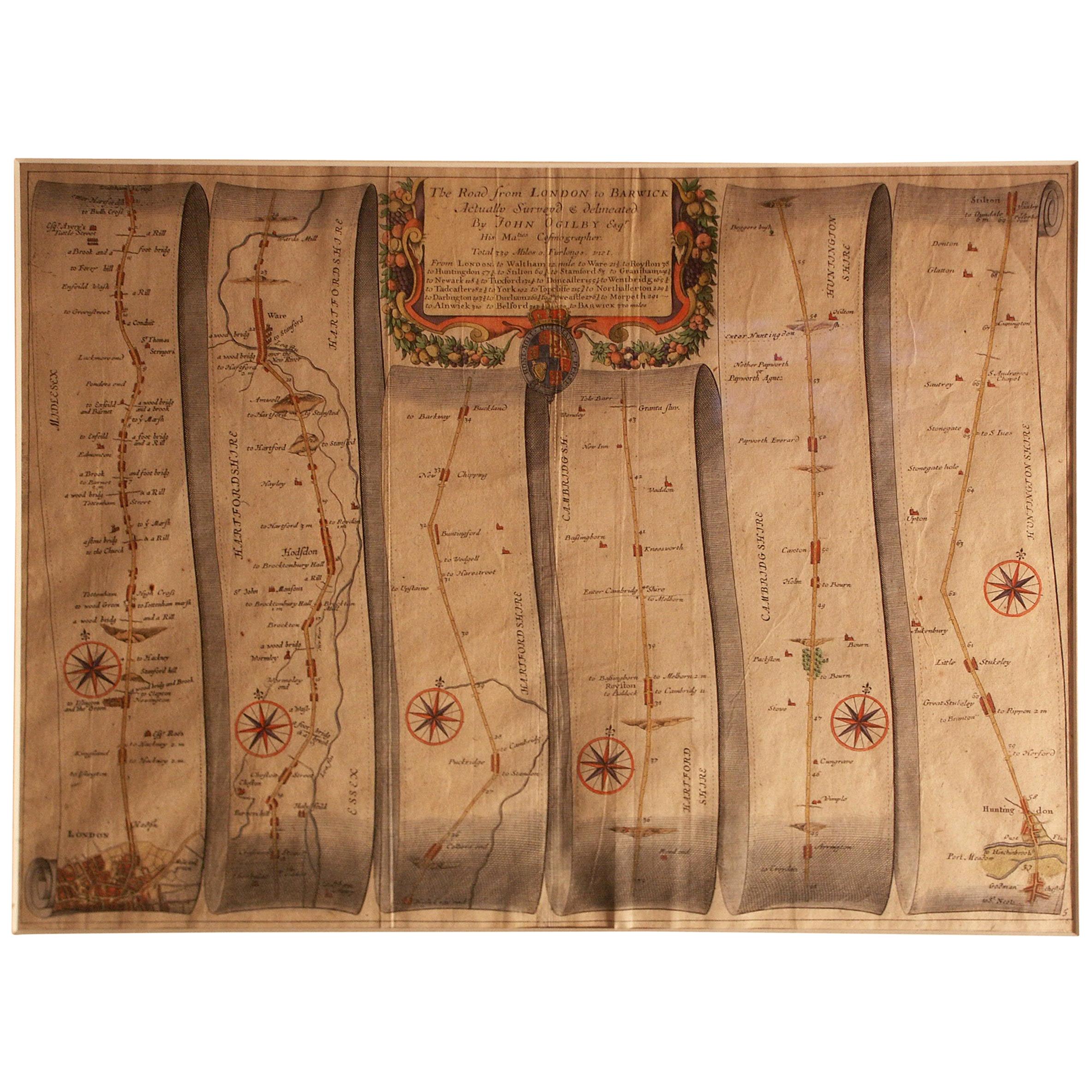
Road Map Britannia 1675/6 No 5 Road London to Barwick, London Stilton Grey Frame
By John Ogilby
Located in BUNGAY, SUFFOLK
John Ogilby (British 1600-1676) cosmographer and geographick printer to Charles II.
A road map from Britannia, 1675/6. No 5, The road from London to Barwick: London to Stilton
In a grey painted and gilded frame.
In a remarkable life John Ogilby pursued, several careers, each ending in misfortune, and yet he always emerged undeterred, to carry on. His modern reputation is based on his final career, started in his sixty-sixth year, as a publisher of maps and geographical accounts.
Ogilby was born outside Dundee, in 1600, the son of a Scottish gentleman. While he was still a child, the family moved to London. When the elder Ogilby was imprisoned for debt, the young John invested his savings in a lottery, won a minor prize, and settled his father's debts. Unfortunately, not enough money was left to secure John a good apprenticeship; instead, he was apprenticed to a dance master. Ogilby was soon dancing in masques at court but, one day, while executing a particularly ambitious leap, he landed badly. The accident left him with a permanent limp, and ended his dancing career. However, he had come to the attention of Thomas Wentworth, later Earl of Strafford, Charles I's most senior minister. Ever one to exploit his contacts, Ogilby became a dance instructor in Strafford's household.
When Strafford was sent to Ireland, Ogilby accompanied him as Deputy-Master of the Kings Revels, and then Master of Revels. In Dublin, he built the New Theatre, in St. Werburgh Street, which prospered at first, but the Irish Rebellion, in 1641, cost Ogilby his fortune, which he estimated at £2,000, and almost his life. After brief service as a soldier, he returned to England, survived shipwreck on the way, and arrived back penniless.
On his return, Ogilby turned his attention to the Latin classics, as a translator and publisher. His first faltering attempt, in 1649, was a translation of the works of Virgil, but after his marriage to a wealthy widow the same year, his publishing activities received a considerable boost. One means by which Ogilby financed these volumes was by subscription, securing advance payments from his patrons, in return for including their name and coats-of-arms on the plates of illustrations. Another approach was to secure a patron, preferably in the court circle. Ogilby's first patron was Strafford, who found out too late that all leading ministers are dispensable when Charles I assented to his execution in 1641. As he re-established himself, Ogilby sought a new patron, the King himself.
In 1661, Ogilby was approached to write poetry for Charles II's coronation procession; he later published 'The Relation of His Majesties Entertainment Passing Through the City of London', and a much enlarged edition the following year, which included a Fine set of plates depicting the procession. Royal favour was bestowed in 1674 when John Ogilby received the title of 'His Majesty's Cosmographer and Geographick Printer' with a salary of £13.6s.8d per annum.
In 1665, Ogilby left London to avoid the Plague then ravaging the capital. The following year, in the Great Fire of London, Ogilby claimed that he lost his entire stock of books valued at some £3,000, as well as his shop and house, leaving him worth just £5.
As he sought to restore his fortunes, Ogilby was already looking in new directions. The initial opportunity he seized on was the reconstruction of London's burnt-out centre. He secured appointment as a "sworn viewer", whose duty was to establish the property boundaries as they existed before the Fire. Ogilby was assisted in the project by his step-grandson, William Morgan, and by a number of professional surveyors. The result was an outstanding plan of London, on a scale of 100 feet to an inch, on 20 sheets, although it was not printed until after Ogilby's death.
Ogilby then turned his attention to publishing geographical descriptions of the wider-world. In 1667, he issued 'An Embassy from the East India Company of the United Provinces to the Grand Tartar Cham, Emperor of China.' Buoyed by the response to this volume, Ogilby conceived an ambitious project, a multi-volume description of the world. The volumes were joint collaborations, in conjunction with the Dutch publisher Jacob van Meurs. 'Africa', published in 1670, was the least original of the three, both in terms of the text, maps and illustrations. In a similar vein, he issued the 'Atlas Japannensis' (1670), the 'Atlas Chinensis' (1671), and 'Asia' (1673). In 1671, Ogilby published the 'America', translated from Arnold Montanus' Dutch text. The 'America' is certainly the most original, and most important, of Ogilby's various geographical volumes, and its influence and popularity was immediate.
With its completion, Ogilby turned to a project nearer his heart, the description of Britain. Ogilby originally intended to devote one volume to Britain, but as the project evolved, he became more ambitious, as revealed in a prospectus issued in about 1672:
"This having oblig'd our Author to take new Measures ... to compleat within the space of two Years a Work ... considering the Actual survey of the Kingdom, the Delineation and Dimensuration of the Roads, the Prospects and Ground plots of Cities, with other Ornamentals ... into six fair volumes. The Four first comprehending the historical and geographical description of England, with the County-Maps truly and actually survey'd. ... The fifth containing an Ichnographical and Historical Description of all the Principal Road-ways in England and Wales, in two hundred copper sculptures, after a new and exquisite method. The sixth containing a New and Accurate Description of the famous City of London, with the perfect Ichnography thereof ..."
In the proposals, Ogilby emphasised the scale of the undertaking; no-one before him had attempted such a vast project. He estimated the total costs would be £20,000, a staggering amount. The cost of the complete set of six volumes was to be £34. At that time, Wenceslas Hollar...
Category
Antique Late 17th Century British Charles II Maps
Materials
Paper
Framed 17th Century Map of Cumberland, England by John Speed, 1610
By John Speed
Located in Middleburg, VA
A fascinating and richly detailed antique map of Cumberland County in northwest England, drawn and published by the celebrated English cartographer John Spe...
Category
Antique Early 17th Century English British Colonial Maps
Materials
Copper, Gold Leaf

Road Map, John Ogilby, London, Barwick, York, Chester, Darlington, Durham Framed
By John Ogilby
Located in BUNGAY, SUFFOLK
The continuation of the road from London to Barwick beginning at York and extending to Chester in ye Street. Plate ye 4th continuing 76 ½ miles. No 8.
York to Burrowbridge, to Top...
Category
Antique 1670s English Baroque Maps
Materials
Paper
