Items Similar to Antique South America Map Wall Art – Brazil, Andes
Amazon, Rand McNally, 1888

Want more images or videos?
Request additional images or videos from the seller
1 of 9
Antique South America Map Wall Art – Brazil, Andes
Amazon, Rand McNally, 1888
$249.18
£186.02
�€210
CA$346.18
A$372.37
CHF 199
MX$4,389.16
NOK 2,508.98
SEK 2,293.68
DKK 1,600.44
About the Item
Title: Antique South America Map Wall Art – Brazil, Andes
Amazon, Rand McNally
Description:
This original antique atlas map presents the full continent of South America in richly detailed late-19th-century cartographic style by Rand, McNally
Co. The composition balances vast continental scale with finely engraved geographic detail, making it both an informative historical document and a highly decorative wall piece.
Major regions and countries are clearly delineated, including Brazil, Argentina, Chile, Peru, Bolivia, Paraguay, Uruguay, Venezuela, Colombia, and Ecuador. The Amazon River system stretches dramatically across the continent, while the Andes Mountains form a striking vertical backbone along the western edge. Coastlines are crisply defined, with the Atlantic and Pacific oceans rendered in soft tonal shading that adds depth and visual calm.
Inset maps enhance the visual interest, including detailed views of the Isthmus of Panama and the Harbor of Rio de Janeiro, reflecting the period’s commercial and strategic focus. Subtle original color highlights borders and regions without overwhelming the fine line engraving, giving the map a refined, balanced appearance ideal for interior display.
Printed on original atlas paper, this sheet carries the authentic texture and patina of a genuine antique, offering a warmth and presence that modern reproductions cannot replicate. It works beautifully as a statement piece in libraries, studies, offices, or travel-inspired interiors.
Condition report: Even age toning throughout. Light edge wear and minor handling marks consistent with original atlas binding. No major tears or losses; overall a clean, attractive example.
Framing tips: Frame in dark walnut, black, or antique gold with a wide off-white mat to emphasize scale and detail. Museum glass recommended for long-term preservation.
Technique: Color lithograph
Maker: Rand, McNally
Co., United States, late 19th century
Keywords:
antique south america map, south america wall art, rand mcnally map, brazil map antique, amazon river map, andes mountains map, argentina chile map, vintage world map decor, antique atlas map, exploration wall art
- Dimensions:Height: 14.18 in (36 cm)Width: 10.63 in (27 cm)Depth: 0.01 in (0.2 mm)
- Materials and Techniques:
- Place of Origin:
- Period:
- Date of Manufacture:circa 1888
- Condition:Even age toning throughout. Light edge wear and minor handling marks consistent with original atlas binding. No major tears or losses; overall a clean, attractive example.
- Seller Location:Langweer, NL
- Reference Number:Seller: BG-12794-661stDibs: LU3054348232202
About the Seller
5.0
Recognized Seller
These prestigious sellers are industry leaders and represent the highest echelon for item quality and design.
Platinum Seller
Premium sellers with a 4.7+ rating and 24-hour response times
Established in 2009
1stDibs seller since 2017
2,836 sales on 1stDibs
Typical response time: 1 hour
- ShippingRetrieving quote...Shipping from: Langweer, Netherlands
- Return Policy
More From This Seller
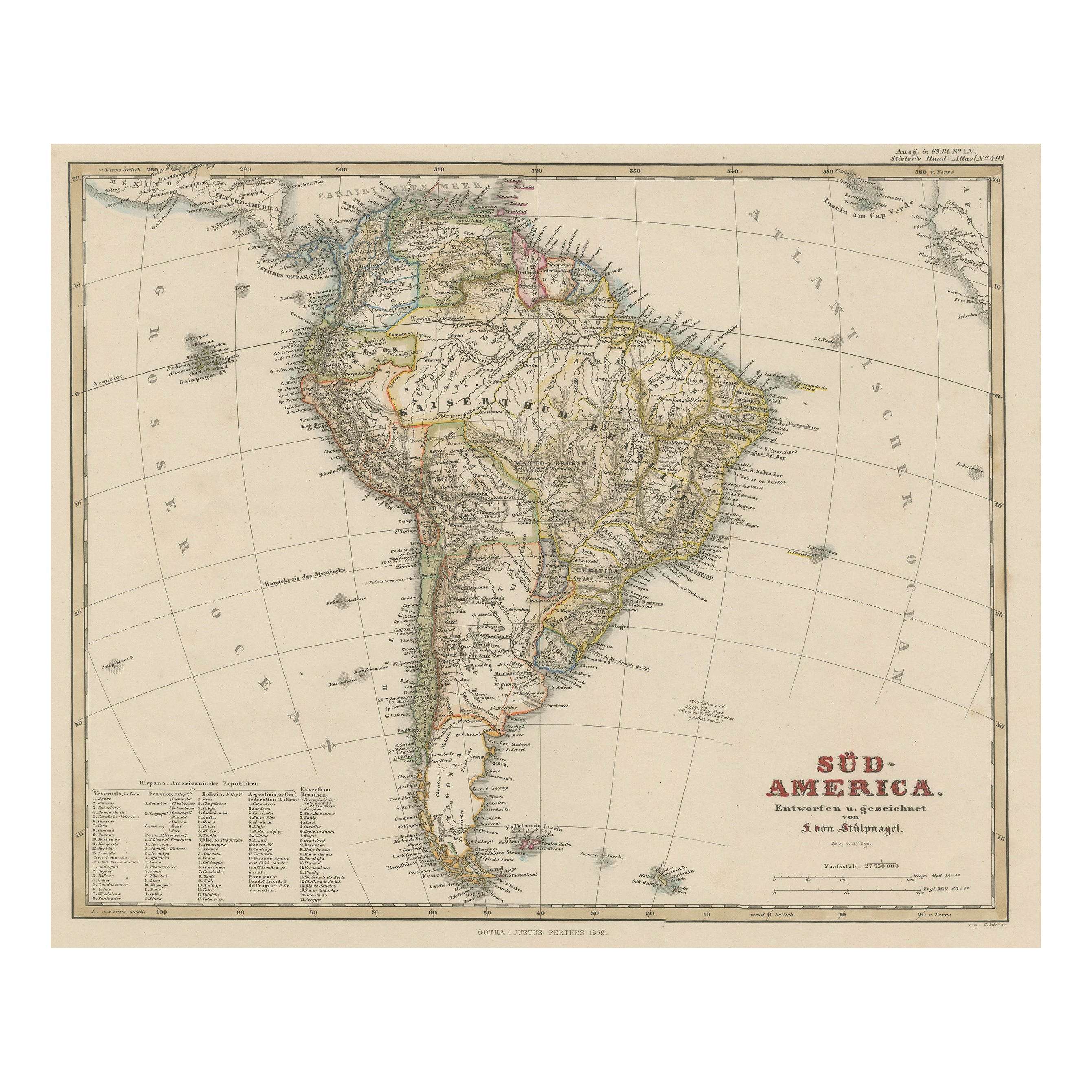
View AllAntique Map of South America with Many Details, ca.1859
Located in Langweer, NL
Original antique map titled 'Süd-America'. Beautiful old map of South America, with many details and legend.
This map originates from Stielers Handatlas, published circa 1859. St...
Category
Antique Mid-19th Century Maps
Materials
Paper
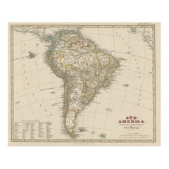
$550 Sale Price
20% Off
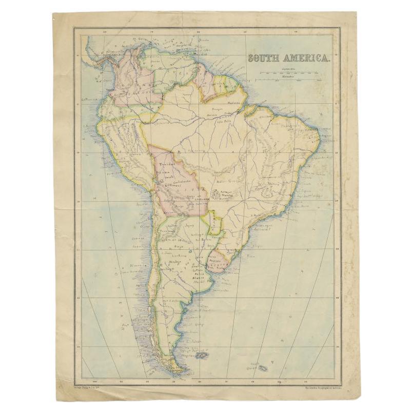
Antique Map of South America by Philip
Son, 1875
Located in Langweer, NL
Antique map titled 'South America'. Old map of South America. Source unknown, to be determined.
Artists and Engravers: George Philip (1800–1882) was a cartographer, map publisher...
Category
Antique 19th Century Maps
Materials
Paper
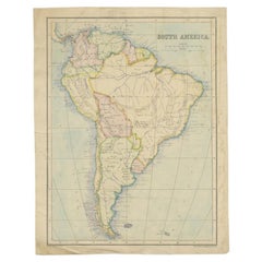
$56 Sale Price
20% Off
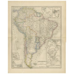
Antique Map of South America by A
C. Black, 1870
Located in Langweer, NL
Antique map titled 'South America'. Original antique map of Map of South America. This map originates from ‘Black's General Atlas of The World’. Published by A & C. Black, 1870.
Category
Antique Late 19th Century Maps
Materials
Paper

$261 Sale Price
20% Off
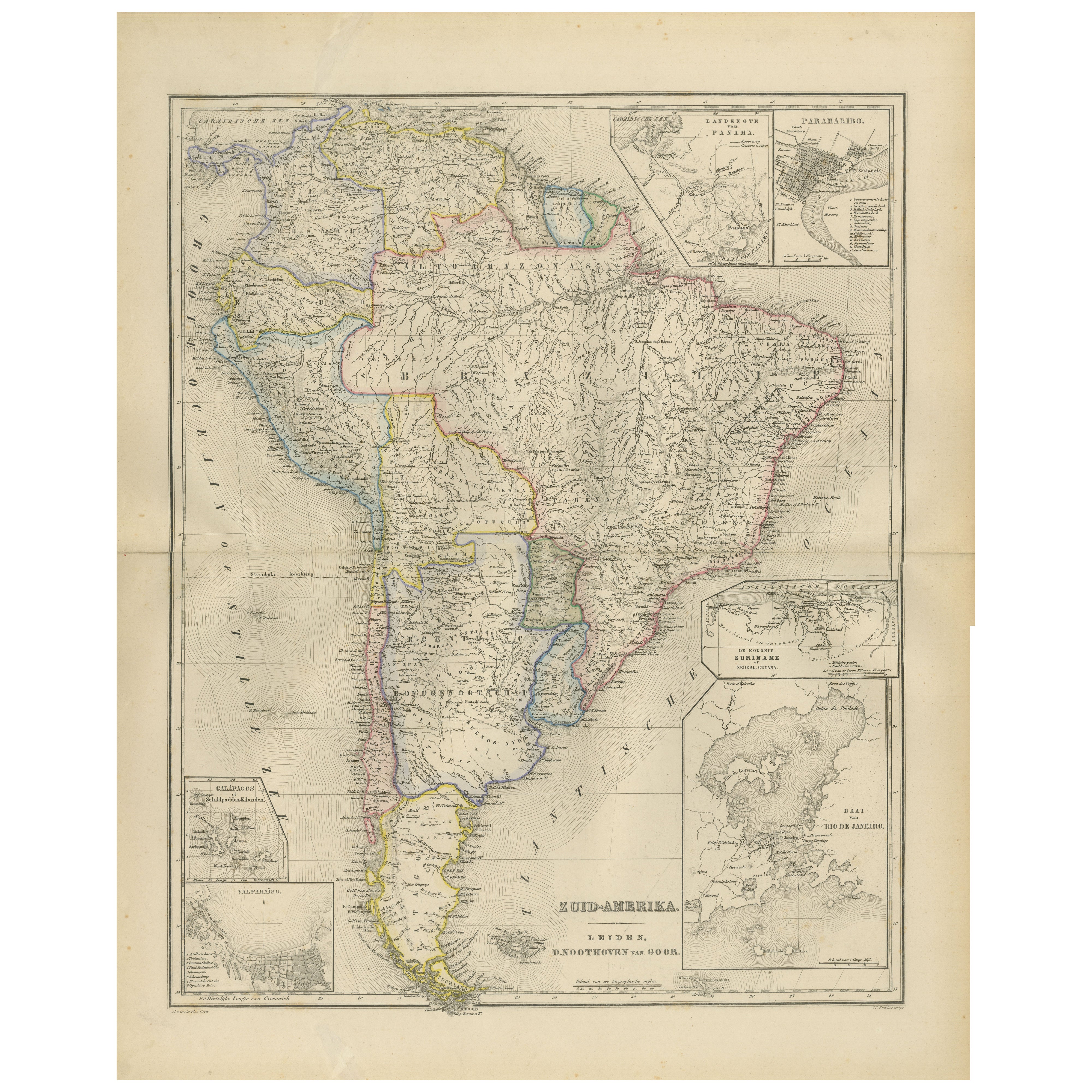
South America Map with Insets – Nieuwe Hand-Atlas, Noothoven van Goor, 1876
Located in Langweer, NL
South America Map with Insets – Nieuwe Hand-Atlas, Noothoven van Goor, 1876
This detailed 19th-century map titled “Zuid-Amerika,” published in Leiden by D. Noothoven van Goor for th...
Category
Antique 1870s Dutch Maps
Materials
Paper
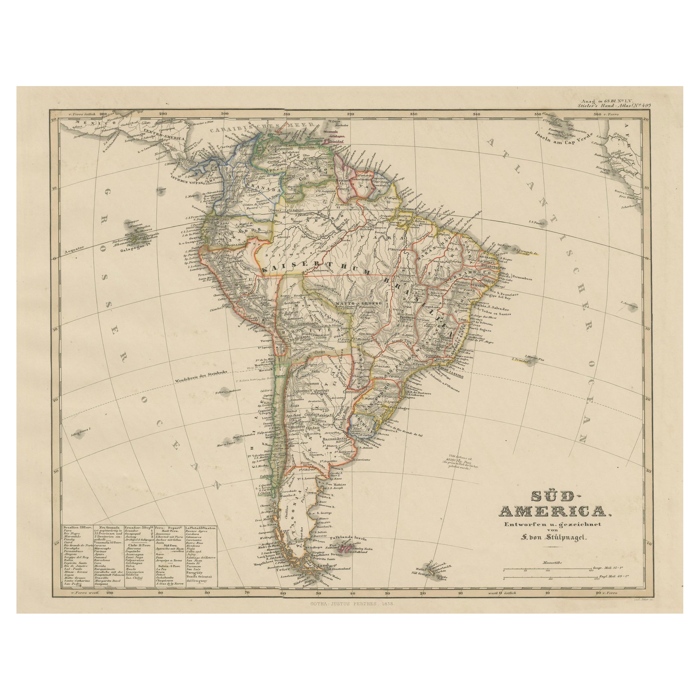
Historic 1858 Map of South America – Pre-Border Consolidation
Located in Langweer, NL
Antique Map of South America – Stülpnagel Engraving Published by Perthes, 1858
Detailed 19th-century engraved map titled "Süd-America", designed and drawn by F. von Stülpnagel and p...
Category
Antique Mid-19th Century German Maps
Materials
Paper

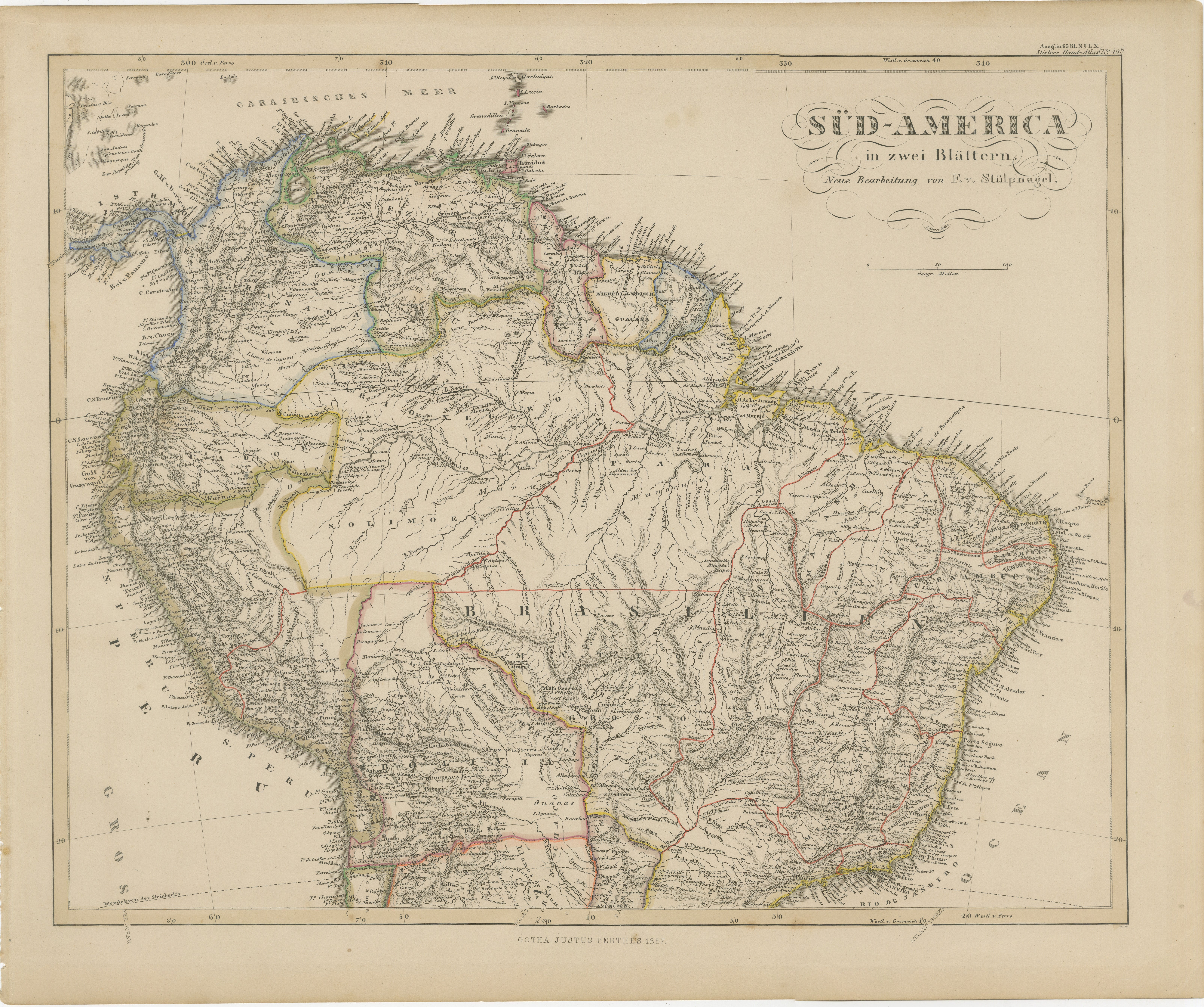
1857 Map of Northern South America – Brazil, Colombia, Peru by Stülpnagel
Located in Langweer, NL
1857 Map of Northern South America – Brazil, Colombia, Peru by Stülpnagel
Antique map titled “Süd-America in zwei Blättern” (South America in Two Sheets), newly edited by V. v. Stül...
Category
Antique Mid-19th Century German Maps
Materials
Paper

You May Also Like
South America, Eastern Part. Century Atlas antique vintage map
Located in Melbourne, Victoria
'The Century Atlas. South America. Eastern Part'
Original antique map, 1903.
Inset map 'Rio de Janeiro and Vicinity'.
Central fold as issued. Map name and number printed on the rev...
Category
Early 20th Century Victorian More Prints
Materials
Lithograph

South America, North-West Part. Century Atlas antique vintage map
Located in Melbourne, Victoria
'The Century Atlas. South America, North-West Part'
Original antique map, 1903.
Central fold as issued. Map name and number printed on the reverse corners.
Sheet 40cm by 29.5cm.
Category
Early 20th Century Victorian More Prints
Materials
Lithograph

Antique Map of South America in Roma Frame
Located in Malibu, CA
Antique map of South America. Displayed in a new Roma frame with museum quality matting. Custom frame in platinum. No print date, but cert...
Category
Antique Late 19th Century Victorian Prints
Materials
Hardwood, Paper

$262 Sale Price
30% Off
Carte du Bresil, antique 1860s engraved map of Brazil
Located in Melbourne, Victoria
'Carte du Bresil'
Engraving with original outline colouring, circa 1860, by Alexandre Vuillemin, published in Paris.
31cm by 41cm (sheet)
21.5cm by 31.5cm (image)
Category
Late 19th Century Victorian More Prints
Materials
Lithograph

Antique Lithography Map, South America, English, Framed, Cartography, Victorian
Located in Hele, Devon, GB
This is an antique lithography map of South America. An English, framed atlas engraving of cartographic interest by John Rapkin , dating to the early Victorian period and later, circ...
Category
Antique Mid-19th Century British Early Victorian Maps
Materials
Wood

Original Antique Decorative Map of South America-West Coast, Fullarton, C.1870
Located in St Annes, Lancashire
Great map of Chili, Peru and part of Bolivia
Wonderful figural border
From the celebrated Royal Illustrated Atlas
Lithograph. Original color.
Published by Fullarton, Edi...
Category
Antique 1870s Scottish Maps
Materials
Paper
