Items Similar to Antique Southern Hemisphere Map by Guillaume De L
Isle, Circa 1783


Want more images or videos?
Request additional images or videos from the seller
1 of 10
Antique Southern Hemisphere Map by Guillaume De L
Isle, Circa 1783
$956
$1,194.9920% Off
£708.14
£885.1820% Off
€796
€99520% Off
CA$1,308.04
CA$1,635.0520% Off
A$1,423.25
A$1,779.0620% Off
CHF 753.59
CHF 941.9920% Off
MX$17,122.64
MX$21,403.3020% Off
NOK 9,568.94
NOK 11,961.1720% Off
SEK 8,754.91
SEK 10,943.6420% Off
DKK 6,066.17
DKK 7,582.7120% Off
About the Item
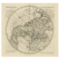
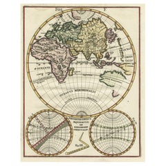
Title: Southern Hemisphere
Terra Australis Map after Delisle
Buache, Paris c.1782
This striking hemispherical map titled “Hémisphere Méridional pour voir plus distinctement Les Terres Australes” presents the southern hemisphere centered on the South Pole, offering a late-18th-century European view of the Antarctic regions and the southern oceans. The map is closely associated with the influential French cartographers Guillaume de l’Isle and Philippe Buache, and was likely issued in a subsequent edition after 1782 from the Atlas géographique et universel published in Paris by Dezauche.
The map reflects the advanced scientific cartography of the French Enlightenment, combining geographic observation with theoretical geography. The southern continents and islands are shown with particular attention to the speculative outlines of Terra Australis, while known landmasses such as southern South America, Africa, Australia, and New Zealand appear with more defined coastlines. Relief is depicted pictorially, adding visual depth to the continental forms.
Of particular interest are the clearly engraved tracks of major exploration voyages across the southern seas, including those of Captain James Cook up to and including his third and final voyage. These routes underline the map’s importance as a document of exploration history, capturing Europe’s rapidly evolving understanding of the Pacific and Antarctic worlds during the late 18th century.
The polar projection emphasizes the vastness of the Southern Ocean and highlights the scientific fascination with the South Pole at a time when it remained entirely unexplored. The map is both a decorative and intellectually significant work, appealing to collectors of early exploration, polar history, and French cartography.
Condition report:
Light overall age toning. Original vertical center fold as issued. Minor foxing and faint scattered spots, mostly marginal. Small light stain near lower margin. Plate impression clear; margins ample and intact.
Framing tips:
This map frames well with a wide off-white or soft grey mat to emphasize the circular composition. A dark wood or black frame enhances contrast and suits both classical and contemporary interiors.
Technique: Copper engraving
Maker: After Guillaume de l’Isle
Philippe Buache, Paris, c.1782
- Creator:Guillaume De L Isle (Artist)
- Dimensions:Height: 21.58 in (54.8 cm)Width: 29.93 in (76 cm)Depth: 0.02 in (0.5 mm)
- Materials and Techniques:Paper,Engraved
- Place of Origin:
- Period:
- Date of Manufacture:circa 1783
- Condition:Wear consistent with age and use. Light overall age toning to the paper. Original vertical center fold as issued. Minor foxing and faint scattered spots, mainly in the margins. Small light stain near lower margin. Plate impression clear; margins ample and intact.
- Seller Location:Langweer, NL
- Reference Number:Seller: BG-021201stDibs: LU305438832933
About the Seller
5.0
Recognized Seller
These prestigious sellers are industry leaders and represent the highest echelon for item quality and design.
Platinum Seller
Premium sellers with a 4.7+ rating and 24-hour response times
Established in 2009
1stDibs seller since 2017
2,816 sales on 1stDibs
Typical response time: 1 hour
- ShippingRetrieving quote...Shipping from: Langweer, Netherlands
- Return Policy
More From This Seller
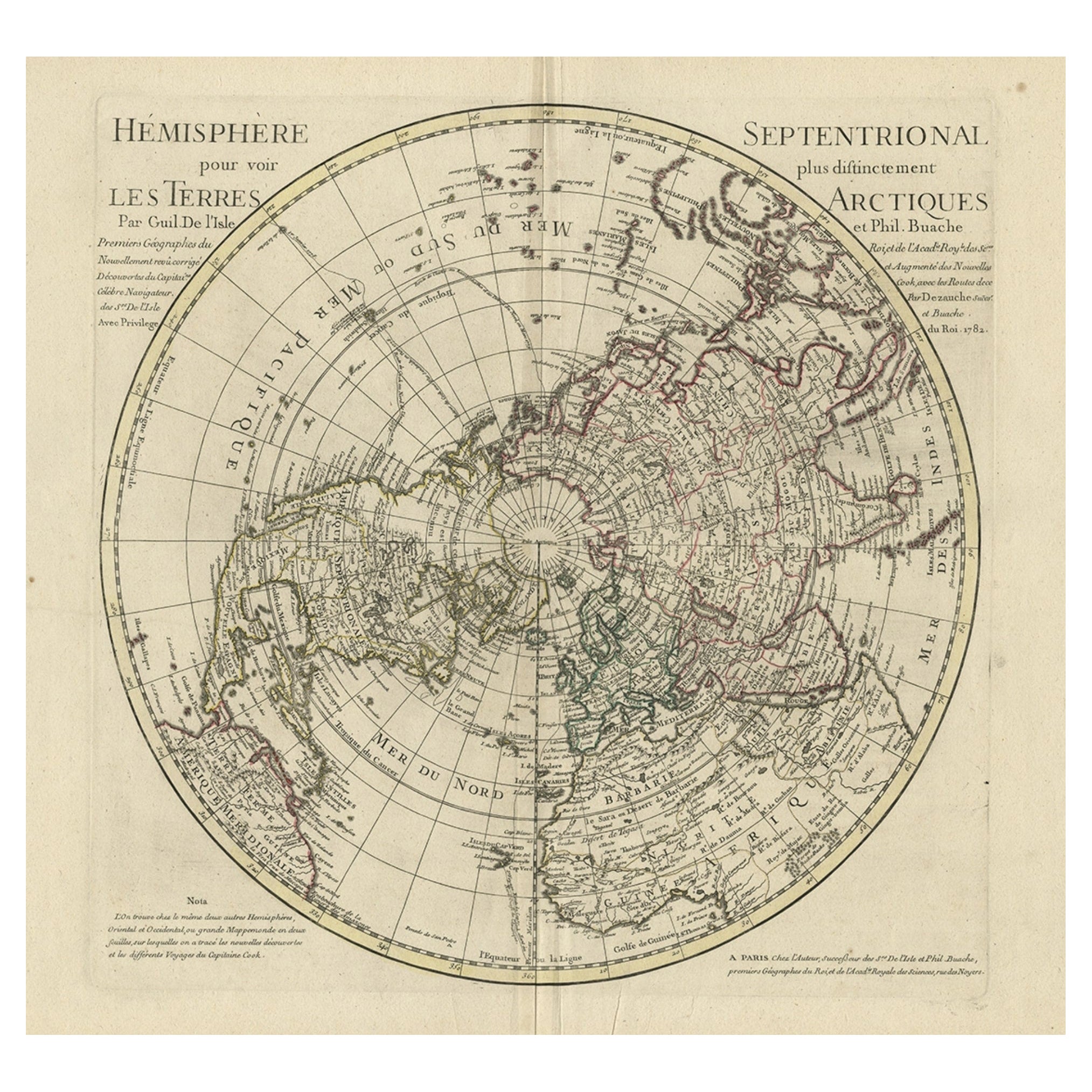
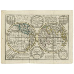
View AllAntique Map of the Northern Hemisphere, 1782
Located in Langweer, NL
Antique map titled 'Hémisphère Septentrional pour voir plus distinctement les Terres Arctiques (..)'.
Map of the Northern Hemisphere, originall...
Category
Antique 1780s Maps
Materials
Paper
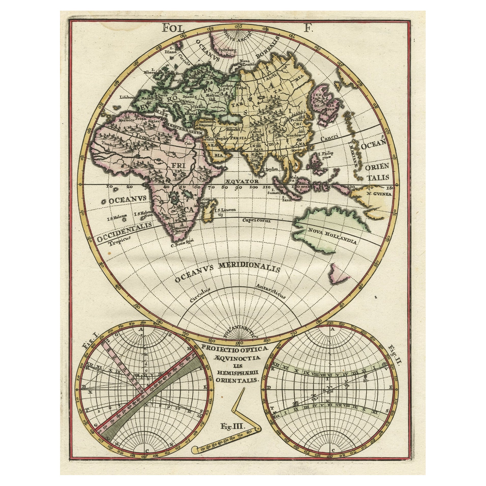
Original Antique Engraving of the Eastern Hemisphere, c.1700
Located in Langweer, NL
Antique map titled 'Proiectio Optica Aequinoctia lis Hemishaerii Orientalis' - Map of the Eastern Hemisphere with Africa, Europe, Asia and Nova Hollandia...
Category
Antique 17th Century Maps
Materials
Paper
$883 Sale Price
20% Off
Antique Map of the World in Hemispheres by Keizer
de Lat, 1788
Located in Langweer, NL
Antique map titled 'Schuine Ronde Aard-Bolle waar van 't Middelpunt is Amsterdam (..)'. Interesting double hemisphere world map on polar projections. In North America, there is a large Island of California. Australia and New Zealand are shown with incomplete coastlines. The map contains six smaller astronomical...
Category
Antique Late 18th Century Maps
Materials
Paper

$480 Sale Price
20% Off
Antique Map of the World with Polar Projections by Keizer
de Lat, 1788
Located in Langweer, NL
Antique map titled 'Schuine Ronde Aard-Klooten (..)'. Interesting double hemisphere world map with polar projections. In North America, there is a...
Category
Antique Late 18th Century Maps
Materials
Paper

$450 Sale Price
25% Off
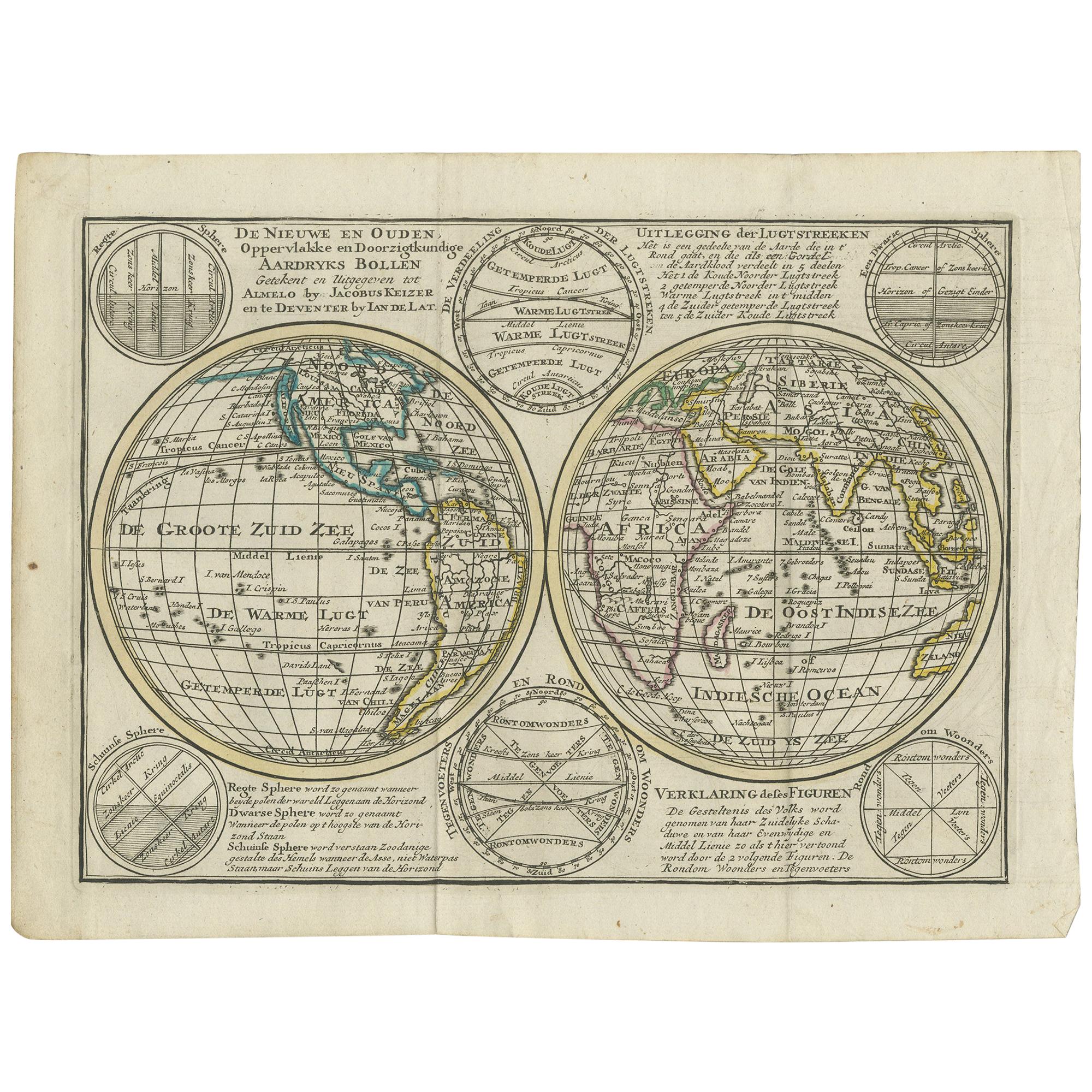
Interesting Antique Engraving of the World in Hemispheres with 6 Diagrams, 1788
Located in Langweer, NL
Antique map titled 'De Nieuwe en Ouden oppervlakke en doorzigtkundige Aardrykes Bollen (..)'. Twin hemispheres surrounded by six diagrams showing various divisions of the globe. Cali...
Category
Antique Late 18th Century Maps
Materials
Paper
$480 Sale Price
20% Off
Antique Map of the Northern Hemisphere and North Pole by Tirion, circa 1754
Located in Langweer, NL
Antique map titled 'Nieuwe Kaart van de Noord Pool na de alderlaatste ondekking int licht gebracht'. Map of the Northern Hemisphere and North Pole, which shows the NE Passage, but no...
Category
Antique Mid-18th Century Dutch Maps
Materials
Paper

$684 Sale Price
24% Off
You May Also Like
Original Antique Map of The Eastern Hemisphere by Dower, circa 1835
Located in St Annes, Lancashire
Nice map of the Eastern Hemisphere
Drawn and engraved by J.Dower
Published by Orr & Smith. C.1835
Unframed.
Free shipping
Category
Antique 1830s English Maps
Materials
Paper

Original Antique Map of The Western Hemisphere by Dower, circa 1835
Located in St Annes, Lancashire
Nice map of the Western Hemisphere
Drawn and engraved by J.Dower
Published by Orr & Smith. C.1835
Unframed.
Free shipping
Category
Antique 1830s English Maps
Materials
Paper

Original Antique Map of The World by Thomas Clerk, 1817
Located in St Annes, Lancashire
Great map of The Eastern and Western Hemispheres
On 2 sheets
Copper-plate engraving
Drawn and engraved by Thomas Clerk, Edinburgh.
Published by Mackenzie And Dent, 1817
...
Category
Antique 1810s English Maps
Materials
Paper

World Map - Etching by Hubert Nicholas-Jaillot - 1719
Located in Roma, IT
World map is an original modern artwork realized by Hubert Nicholas - Jaillot, printed by Louis Cordier in Paris 1719.
Etching on copper
The artwork depicts two hemispheres, conti...
Category
1710s Old Masters Figurative Prints
Materials
Etching

Original Antique Map of South America. C.1780
Located in St Annes, Lancashire
Great map of South America
Copper-plate engraving
Published C.1780
Two small worm holes to left side of map
Unframed.
Category
Antique Early 1800s English Georgian Maps
Materials
Paper

North
South America: A 17th Century Hand-colored Map by Jansson
Goos
By Johannes Janssonius
Located in Alamo, CA
A 17th century hand-colored map of North & South America entitled "Americae Descriptio" by the cartographer Johannes Jansson, published in Jansson's Atlas Minor in Amsterdam in 1628....
Category
Antique 1620s Dutch Maps
Materials
Paper

$1,020 Sale Price
20% Off
More Ways To Browse
Antique Russian Rugs
For Kids
Sterling Silver Flatware Set Service For 12
Tufted Bar
Pair Of French Antique Armchairs
1970s Brass Glass Coffee Table
Charles Rennie Mackintosh For Cassina
Glass Salt
Italian Modern Silver Vases
Vintage Resin Tables
Antique English Country Furniture
Blue Kilim Vintage
Contemporary Side Tables And Stools
Decorative Wall Plate
Mid Century Modern Corner Chair
Dining Tables With Brass Inlay
Oak Mid Century Armchair
Solid Wood Side Table Stool