Items Similar to Antique St Christopher
Nevis Map, English, Caribbean Cartography, Georgian


Want more images or videos?
Request additional images or videos from the seller
1 of 13
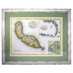
Antique St Christopher
Nevis Map, English, Caribbean Cartography, Georgian
$1,488.28
£1,086
€1,277.02
CA$2,064.10
A$2,222.19
CHF 1,190.02
MX$26,776.57
NOK 15,014.82
SEK 13,740.98
DKK 9,542.41
About the Item
This is a superb antique map of St Christopher and Nevis. An English, framed Caribbean island cartography engraving, dating to the Georgian period and later, circa 1780. A fascinating depiction of these twin islands, rich in colonial and naval history.
Excellent Georgian cartography showcasing the islands of St Christopher (St Kitts) and Nevis in remarkable detail
Based on the work of a naval officer, with annotated positions of British and French fleets around the islands
Printed in London from the original engraving by John I. Fielding, in conjunction with other London print houses
Pink and blue hand-coloured detail accentuates coastal and territorial divisions, adding superb visual appeal
Presented behind clear glass within a later antique frame, in good order throughout
Dressed to the rear with hanging braid for ease of display in the home, study or office
Displays a captivating level of period detail, charting harbours, settlements, and topographical features
Dates given for the day of description (February 1782) and the print date in April that year
A charming example of Georgian period cartographic art, this antique map of St Christopher and Nevis captures the essence of 18th century exploration and colonial influence in the Caribbean, making it a fine addition for collectors and admirers of naval or geographical history. Delivered ready to display.
Dimensions:
Max Width: 50.5cm (20'')
Max Depth: 1.5cm (.5'')
Max Height: 44.5cm (17.5'')
Map Width: 38cm (15'')
Map Height: 31.5cm (12.5'')
- Dimensions:Height: 17.52 in (44.5 cm)Width: 19.89 in (50.5 cm)Depth: 0.6 in (1.5 cm)
- Style:Georgian (Of the Period)
- Materials and Techniques:
- Place of Origin:
- Period:
- Date of Manufacture:Circa 1780
- Condition:Wear consistent with age and use. Presented in good antique condition.
- Seller Location:Hele, Devon, GB
- Reference Number:Seller: 256271stDibs: LU2645347309702
About the Seller
5.0
Platinum Seller
Premium sellers with a 4.7+ rating and 24-hour response times
Established in 2005
1stDibs seller since 2017
1,090 sales on 1stDibs
Typical response time: <1 hour
- ShippingRetrieving quote...Shipping from: Hele, Devon, United Kingdom
- Return Policy
More From This Seller
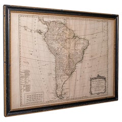
View AllAntique South America Map, English, Framed Cartography, De La Rochette, Georgian
Located in Hele, Devon, GB
This is a superb antique map of South America. An English, framed cartographic engraving by Louis Stanislas De La Rochette, dating to the Georgian period and later, circa 1790. A fas...
Category
Antique 1790s British Georgian Maps
Materials
Glass, Paper
Antique Lithography Map, West Africa, English, Framed, Cartography, Victorian
Located in Hele, Devon, GB
This is an antique lithography map of Western Africa. An English, framed atlas engraving of cartographic interest by John Rapkin, dating to the early Victorian period and later, circ...
Category
Antique Mid-19th Century British Early Victorian Maps
Materials
Wood

Antique County Map, Sussex, English, Framed Lithography, Cartography, Victorian
Located in Hele, Devon, GB
This is an antique lithography map of Sussex. An English, framed atlas engraving of cartographic interest, dating to the mid 19th century and later.
Superb lithography of Sussex an...
Category
Antique Mid-19th Century British Victorian Maps
Materials
Paper

Antique Lithography Map, Black Sea, English, Framed, Cartography, Victorian
Located in Hele, Devon, GB
This is an antique lithography map of the Black Sea region. An English, framed atlas engraving of cartographic interest by John Rapkin, dating to the early Victorian period and later...
Category
Antique Mid-19th Century British Early Victorian Maps
Materials
Wood

Antique Somerset Map, Thomas Kitchin, English, Cartographic Reference, Georgian
Located in Hele, Devon, GB
This is a fine antique Somerset map. An 18th century English cartographic county reference engraving by Thomas Kitchin (1718–1784), dating to the Georgian period, circa 1780. A beaut...
Category
Antique 1780s British Georgian Maps
Materials
Glass, Paper

Antique Lithography Map, Cumbria, English, Framed Cartography Interest, Georgian
Located in Hele, Devon, GB
This is an antique lithography map of Cumbria. An English, framed engraving of cartographic interest, dating to the early 18th century and later.
...
Category
Antique Early 18th Century British Georgian Maps
Materials
Wood

You May Also Like
Old Map of the island of Saint Christopher or St. Kitts in the Caribbean, c.1765
Located in Langweer, NL
Antique map titled 'Carte de l'Isle de Saint-Christophe'.
A detailed map of the island of Saint Christopher or St. Kitts showing mountain ranges, port towns and parishes. This map ...
Category
Antique 18th Century Maps
Materials
Paper

19th Century Nautical Chart of Martinique
Located in Norwell, MA
Original map of Martinique from 1887 with chartered waters around the island. Prepared from a French survey, completed in 1825, showing town, ports, rivers and tributaries. Published...
Category
Antique 19th Century Nautical Objects

Hand-Colored Map of West India Islands: St. Christopher
s, St. Lucia and Nevis
Located in Langweer, NL
This map, titled "West India Islands," was published by John Thomson & Co. in 1821 as part of *Thomson's New General Atlas.* The map offers detailed depictions of three key islands i...
Category
Antique 1820s Maps
Materials
Paper
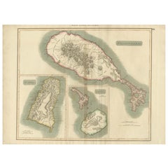
$551 Sale Price
20% Off
Curaçao map - C. van Baarsel en zoon
Located in UTRECHT, UT
“Kaart van het eiland Curaçao.”, “Algemeene kaart der Caraïbische eilanden”, “Plan van het fort Amsterdam op Curaçao” from the atlas “Atlas der overzeesche bezittingen van Zijne Maje...
Category
Antique 1810s Dutch Other Maps
Materials
Paper
Vintage Map of the Greater Antilles and Lesser Antilles
Located in Langweer, NL
Vintage map titled 'Antilles'. Original map of the Antilles. Shows the Cayman Islands, Cuba, Hispaniola (subdivided into the nations of the Dominican Republic and Haiti), Jamaica, and Puerto Rico. Also shows the Lesser Antilles...
Category
20th Century Maps
Materials
Paper
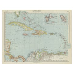
$133 Sale Price
20% Off
St. Christophe
St. Kitts
Island: An 18th Century Hand-colored Map by Bellin
By Jacques-Nicolas Bellin
Located in Alamo, CA
Jacques Bellin's copper-plate map of the Caribbean island of Saint Kitts entitled "Carte De De l'Isle St. Christophe Pour servir á l'Histoire Genle. des V...
Category
Antique Mid-18th Century French Maps
Materials
Paper
