Items Similar to Antique Town Plan Map, Poole, English, Framed Cartography, Georgian, Circa 1780


Want more images or videos?
Request additional images or videos from the seller
1 of 13
Antique Town Plan Map, Poole, English, Framed Cartography, Georgian, Circa 1780
$857.89
£626
€736.11
CA$1,189.80
A$1,280.93
CHF 685.96
MX$15,434.75
NOK 8,654.95
SEK 7,920.68
DKK 5,500.51
About the Item
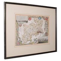
This is an antique town plan map of Poole in Dorset. An English, framed atlas engraving, dating to the 18th century and later.
Fascinating cartography with annotated streets and places
Displaying a desirable aged patina within a later frame
Dedicated to Lieutenant Colonel Thomas Calcraft and Joshua Mauger,
Both were parliamentarians for Poole from 1761 to 1774, and 1768 - 1780 respectively
Hand colouring adds an appealing level of detail to the town plan
Dressed to the rear with mounting wire for ease of hanging
This is a charming antique town plan map of Poole, with a fascinating level of local detail. Delivered ready to display.
Dimensions:
Max Width: 42.5cm (16.75'')
Max Depth: 2.5cm (1'')
Max Height: 49.5cm (19.5'')
Map Width: 28cm (11'')
Map Height: 35cm (13.75'')
- Dimensions:Height: 19.49 in (49.5 cm)Width: 16.74 in (42.5 cm)Depth: 0.99 in (2.5 cm)
- Style:George III (Of the Period)
- Materials and Techniques:
- Place of Origin:
- Period:
- Date of Manufacture:circa 1780
- Condition:Wear consistent with age and use. Presented in very good antique condition.
- Seller Location:Hele, Devon, GB
- Reference Number:Seller: 244331stDibs: LU2645340696112
About the Seller
5.0
Platinum Seller
Premium sellers with a 4.7+ rating and 24-hour response times
Established in 2005
1stDibs seller since 2017
1,090 sales on 1stDibs
Typical response time: <1 hour
- ShippingRetrieving quote...Shipping from: Hele, Devon, United Kingdom
- Return Policy
More From This Seller
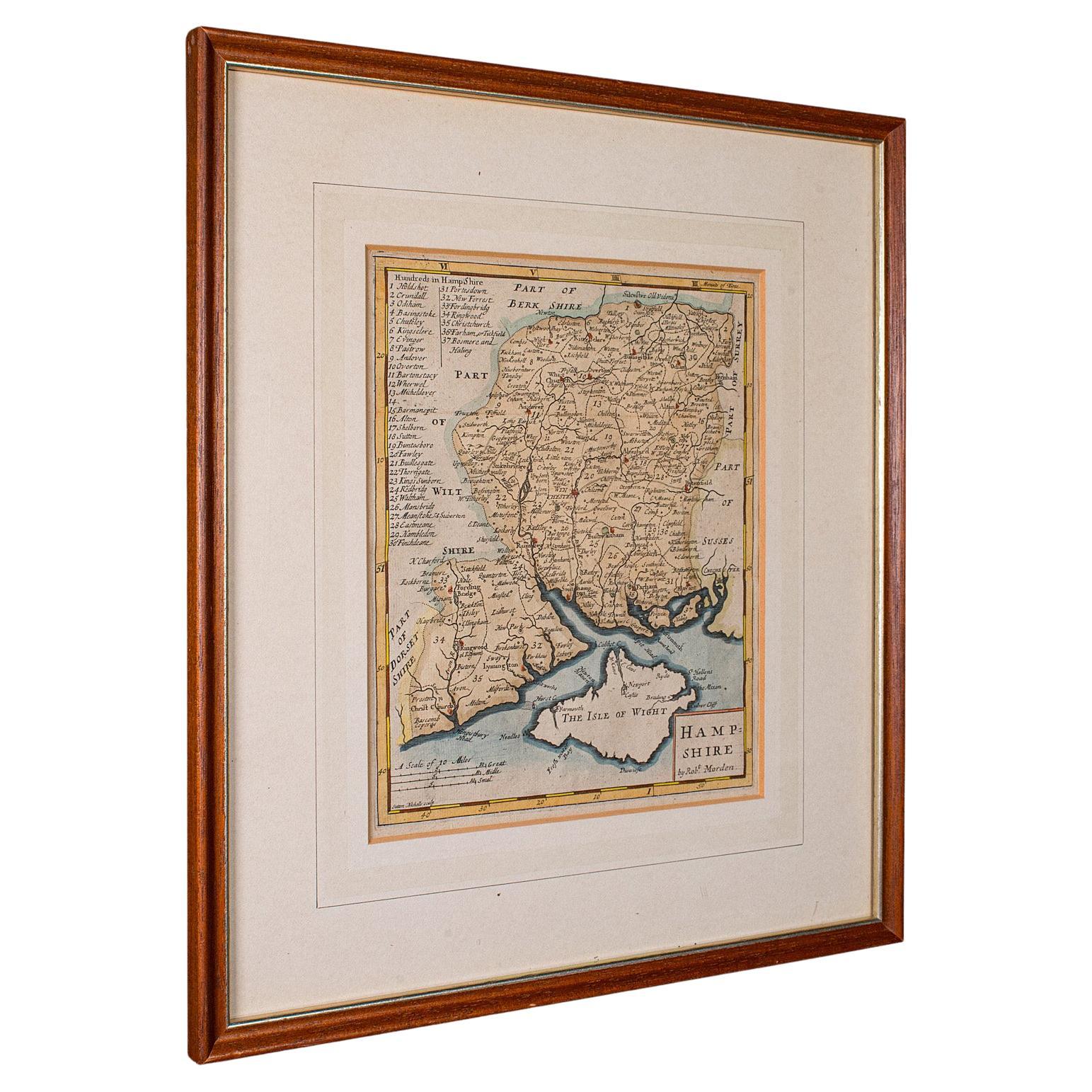
View AllAntique County Map, Hampshire, English, Framed Cartography, Robert Morden, 1700
Located in Hele, Devon, GB
This is an antique county map of Hampshire. An English, framed atlas engraving of cartographic interest By Robert Morden, dating to the late 17th century and later.
Superb lithogra...
Category
Antique Late 17th Century British Other Maps
Materials
Glass, Wood, Paper

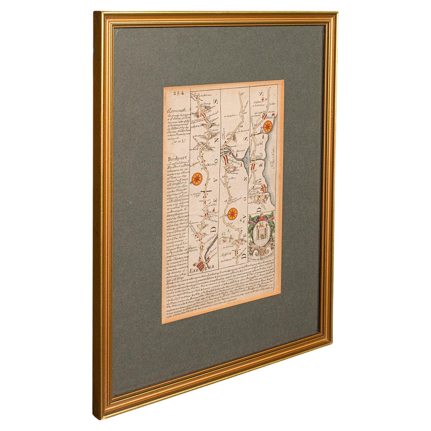
Antique Coach Road Map, East Devon, English, Framed, Cartography, Georgian, 1720
Located in Hele, Devon, GB
This is an antique coach road map of East Devon. An English, framed lithograph engraving of regional interest, dating to the early 18th century and later.
Fascinating 18th century h...
Category
Antique Early 18th Century British Georgian Maps
Materials
Wood

Antique County Map, Middlesex, English, Framed, Litho, Cartography, Victorian
Located in Hele, Devon, GB
This is an antique lithography map of Middlesex. An English, framed atlas engraving of cartographic interest, dating to the mid 19th century and later.
Superb lithography of Middle...
Category
Antique Mid-19th Century British Victorian Maps
Materials
Paper
Antique County Map, Oxfordshire, English, Framed Cartography Interest, Victorian
Located in Hele, Devon, GB
This is an antique lithography map of Oxfordshire. An English, framed atlas engraving of cartographic interest, dating to the mid 19th century and later.
Superb lithography of Oxfo...
Category
Antique Mid-19th Century British Mid-Century Modern Maps
Materials
Wood

Antique Lithography Map, Environs of Southampton, English, Framed, Victorian
Located in Hele, Devon, GB
This is an antique lithography map 'The Environs of Southampton'. An English, framed town engraving of cartographic interest by John James Dower, dating to the Victorian period and ...
Category
Antique Late 19th Century British Victorian Maps
Materials
Wood
Large Antique Lithography Map of Kent, English, Cartography, Robert Morden, 1700
Located in Hele, Devon, GB
This is a large antique lithography map of Kent. An English, framed atlas engraving of cartographic interest by Robert Morden, dating to the early 18th century and later.
Superb li...
Category
Antique Early 18th Century British Queen Anne Maps
Materials
Glass, Wood, Paper

You May Also Like
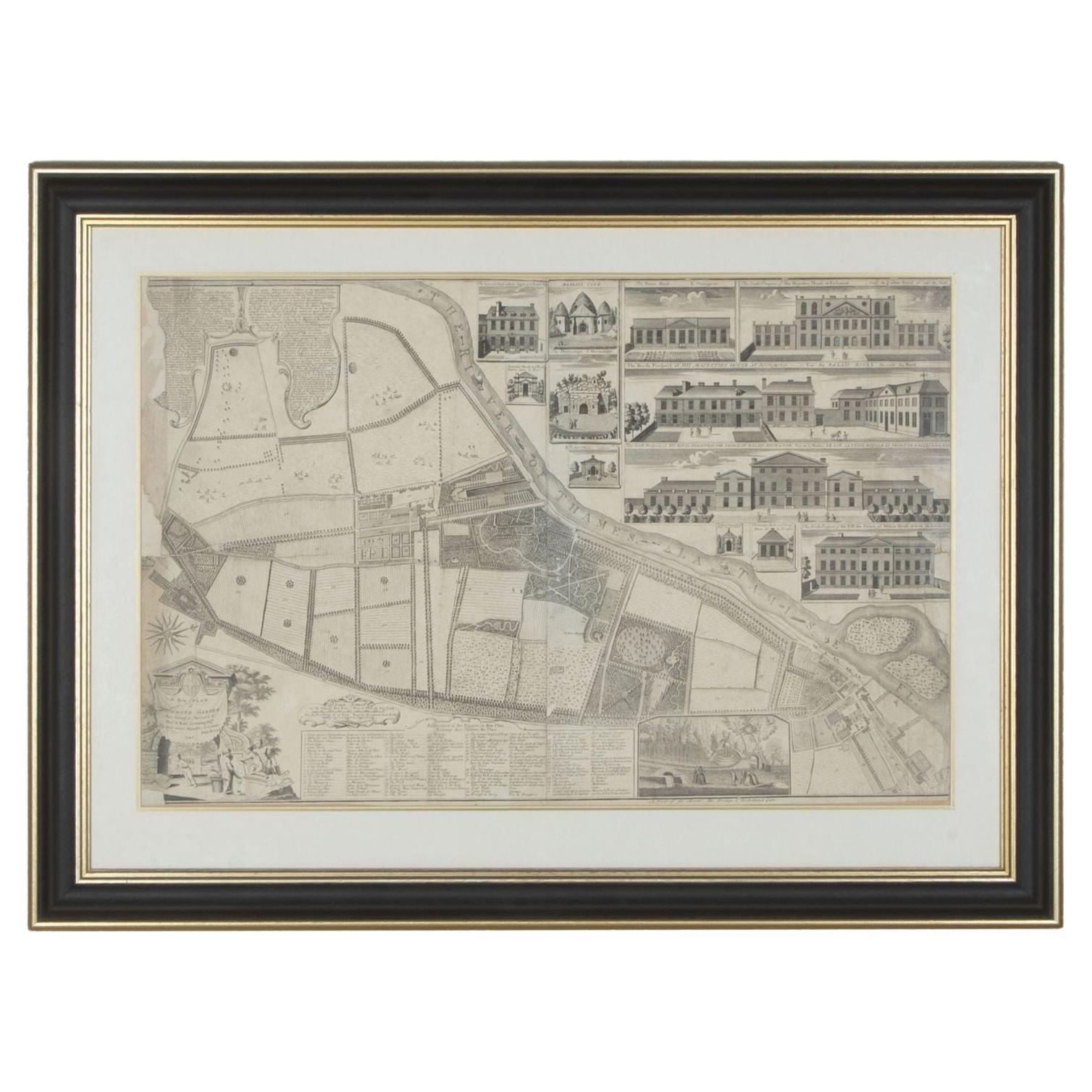
1748 Map of Richmond Upon Thames by John Roque
Located in Gloucestershire, GB
A 1748 map of Richmond-Upon-Thames by famed surveyor and cartographer, John Roque. Placed in a simple black and gilt frame. The map is in fair condition but there are small sections ...
Category
Antique Mid-18th Century English Maps
Materials
Wood, Paper

Antique Map of Essex by Overton, circa 1710
Located in Langweer, NL
Antique map titled 'Essex, devided into Hundreds, with the most antient and fayre Towne Colchester (..)'. Map of Essex, England. Includes an inset town pl...
Category
Antique Early 18th Century Maps
Materials
Paper

$903 Sale Price
20% Off
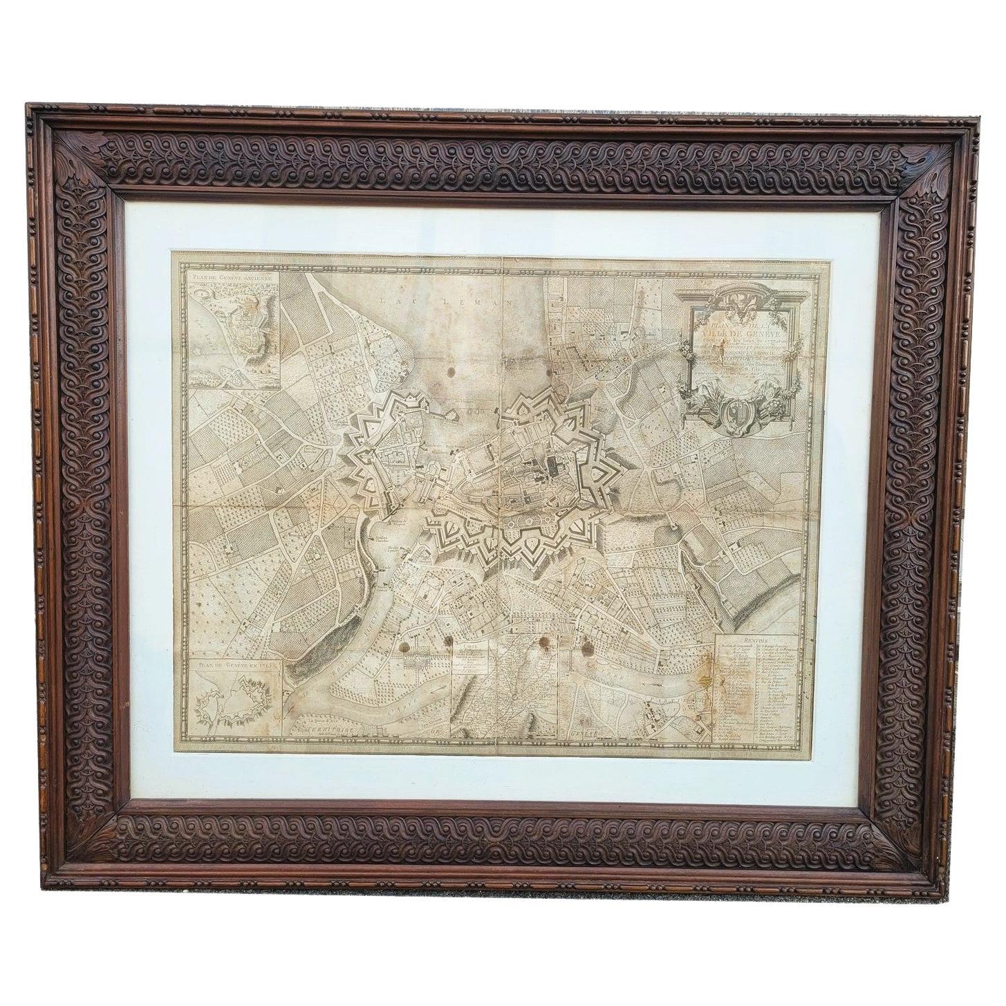
Map Of The City Of Geneva, Framed Engraving, Late 18th Century
Located in MARSEILLE, FR
Beautiful engraving representing the city of Geneva corrected in 1775 and 1793
The engraving also presents inserts with the evolution of the city, the plan of ancient Geneva and ...
Category
Antique Late 18th Century Swiss Louis XV Prints
Materials
Paper

Antique Map of the City of Paris by Tirion
1763
Located in Langweer, NL
Antique map titled 'Nieuwe Kaart der platte Grond van de Stad Parys (..)'. Beautiful city plan of Paris, France. This map originates from 'Nieuwe en Beknopte Hand-Atlas, bestaande in...
Category
Antique Mid-18th Century Maps
Materials
Paper

Large Original Antique Folding Map of Manchester, England, Dated 1793
Located in St Annes, Lancashire
Superb map of Manchester and Salford
Folding map. Printed on paper laid on to the original canvas
Unframed.
Published by C. Laurent, 1793.
Free shippi...
Category
Antique 1790s English Georgian Maps
Materials
Canvas, Paper

Mid-18th Century Hand Drawn English Farm Map on Vellum, circa 1740s
Located in San Francisco, CA
Mid-18th century hand drawn English farm map on Vellum circa 1740s
Henry Maxted & Isaac Terry, Surveyors.
A Map of a Farm in the Parish of Blean in the County of KENT: Belonging to Mrs Elizabeth Hodgson circa 1743.
A beautiful hand drawn map...
Category
Antique Mid-18th Century English Maps
Materials
Lambskin

More Ways To Browse
George Poole
1960s Glass Top Coffee Table
Black Glass Coffee Tables
Mid Century Wrought Iron Chairs
Earth Toned Rug
Black Marble Table Vintage
Goblets
Mid Century Modern Yellow Chair
Paulin Pierre
Used Pianos Pianos
18th Century Engravings
Antique Carved Wood Chair
Black Scandinavian Modern Dining Chairs
Dutch Mid Century Modern Table
Gold Modern Coffee Table
Iconic Modern Furniture
Japanese Metal
Midcentury Modern Gray Glass Vase