Items Similar to Antique Wyoming Map Wall Art – Railroads, Mountains
Plains, circa 1888

Want more images or videos?
Request additional images or videos from the seller
1 of 11
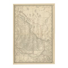
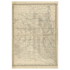
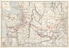
Antique Wyoming Map Wall Art – Railroads, Mountains
Plains, circa 1888
$284.77
£212.60
€240
CA$395.64
A$425.56
CHF 227.43
MX$5,016.18
NOK 2,867.41
SEK 2,621.35
DKK 1,829.07
About the Item
Title: Antique Wyoming Map Wall Art – Railroads
Rocky Mountains, Rand McNally
Description:
This original antique atlas map presents the state of Wyoming in fine detail, showing mountain ranges, plains, river systems, early settlements, and developing railroad routes across the territory. Finely engraved relief gives the landscape a strong sense of depth, while the restrained palette keeps the overall appearance calm and decorative.
Published by Rand, McNally
Co. in the late 19th century, the map captures Wyoming during a formative period of westward expansion and infrastructure growth. The Rocky Mountains, Laramie Plains, and surrounding highlands are carefully rendered, alongside towns, forts, and transport routes that shaped the region’s development.
Subtle color accents highlight railroad lines and boundaries against a largely monochrome ground, giving the map an architectural, almost drawing-like quality. The horizontal format reads beautifully as wall art, making it well suited to studies, offices, libraries, or interiors with a Western or travel theme.
Printed on original period atlas paper, the sheet retains the authentic surface texture and gentle patina expected of a genuine antique map. When framed, it functions as an elegant historical and decorative object rather than a purely technical chart.
Condition report: Light age toning consistent with age. Minor edge wear - especially in the top - and small handling marks from original atlas binding. Overall clean and well preserved. Please study the images carefully.
Framing tips: Especially effective in walnut, dark oak, or black frames with an ivory or warm off-white mat. Museum glass recommended.
Technique: Color lithograph
Maker: Rand, McNally
Co., United States, late 19th century
Keywords:
antique wyoming map, wyoming wall art, rand mcnally map, rocky mountains map, american west map, railroad map wyoming, historical wyoming map, antique atlas map, yellowstone map, laramie plains, cheyenne wyoming map, casper wyoming, rock springs wyoming, sweetwater river, green river wyoming
- Dimensions:Height: 10.63 in (27 cm)Width: 14.1 in (35.8 cm)Depth: 0.01 in (0.2 mm)
- Materials and Techniques:
- Place of Origin:
- Period:
- Date of Manufacture:circa 1888
- Condition:Light age toning consistent with age. Minor edge wear - especially in the top - and small handling marks from original atlas binding. Overall clean and well preserved. Please study the images carefully.
- Seller Location:Langweer, NL
- Reference Number:Seller: BG-12794-681stDibs: LU3054348231342
About the Seller
5.0
Recognized Seller
These prestigious sellers are industry leaders and represent the highest echelon for item quality and design.
Platinum Seller
Premium sellers with a 4.7+ rating and 24-hour response times
Established in 2009
1stDibs seller since 2017
2,838 sales on 1stDibs
Typical response time: 1 hour
- ShippingRetrieving quote...Shipping from: Langweer, Netherlands
- Return Policy
More From This Seller
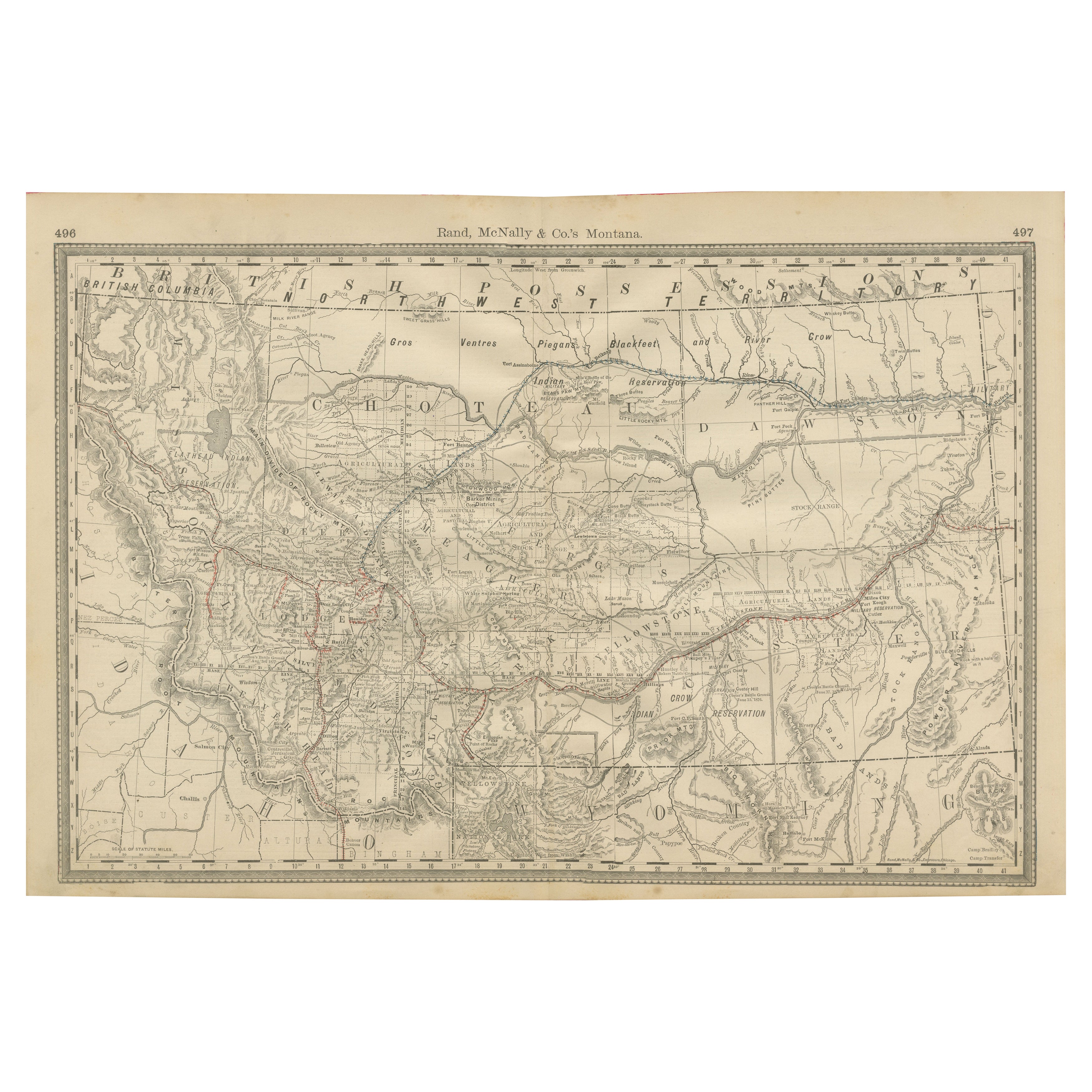
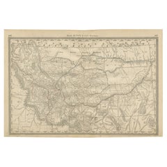
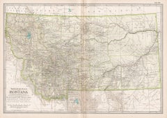
View AllOld Map of Montana – Railroads, Indian Reservations
Frontier Settlements 1888
Located in Langweer, NL
Antique Map of Montana – Railroads, Indian Reservations & Frontier Settlements, 1888
This antique engraved map depicts the Territory of Montana in 1888, engraved and published by Ra...
Category
Antique Late 19th Century American Maps
Materials
Paper
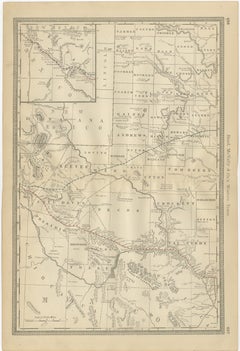
1888 Idaho Map – The Gem State’s Railroads, Mining Camps
Counties
Located in Langweer, NL
Antique Map of Idaho – Railroads, Mining Camps & Counties, 1888
This antique engraved map depicts the Territory of Idaho in 1888, engraved and published by Rand, McNally & Co. in Ch...
Category
Antique Late 19th Century American Maps
Materials
Paper
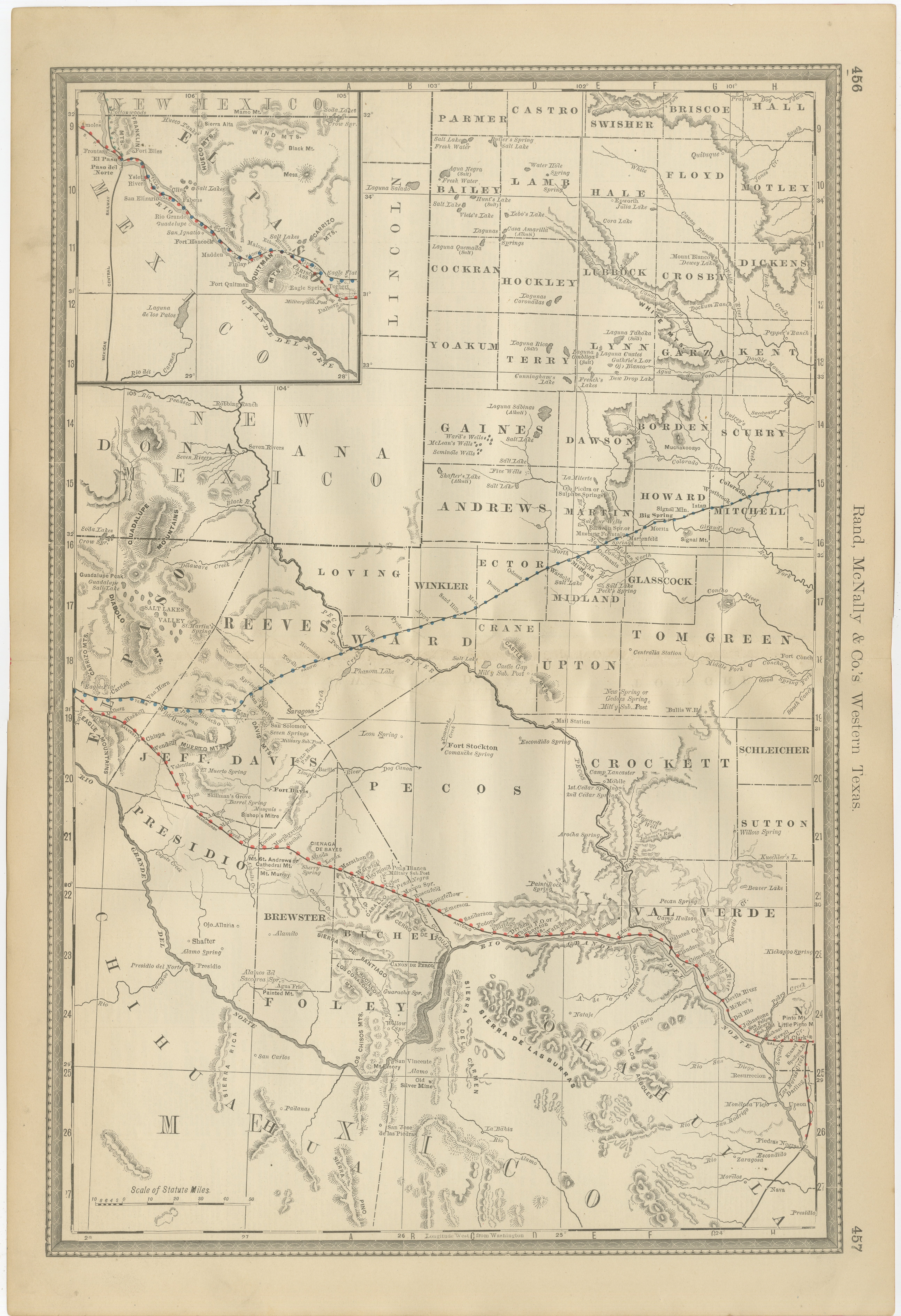
Western Texas Antique Map 1888 – Railroads, Counties
Frontier Towns
Located in Langweer, NL
Western Texas Map 1888 – Rand McNally Antique Lithograph
This antique 1888 map of Western Texas, published by Rand, McNally & Co., depicts the vast frontier counties of the region a...
Category
Antique Late 19th Century American Maps
Materials
Paper
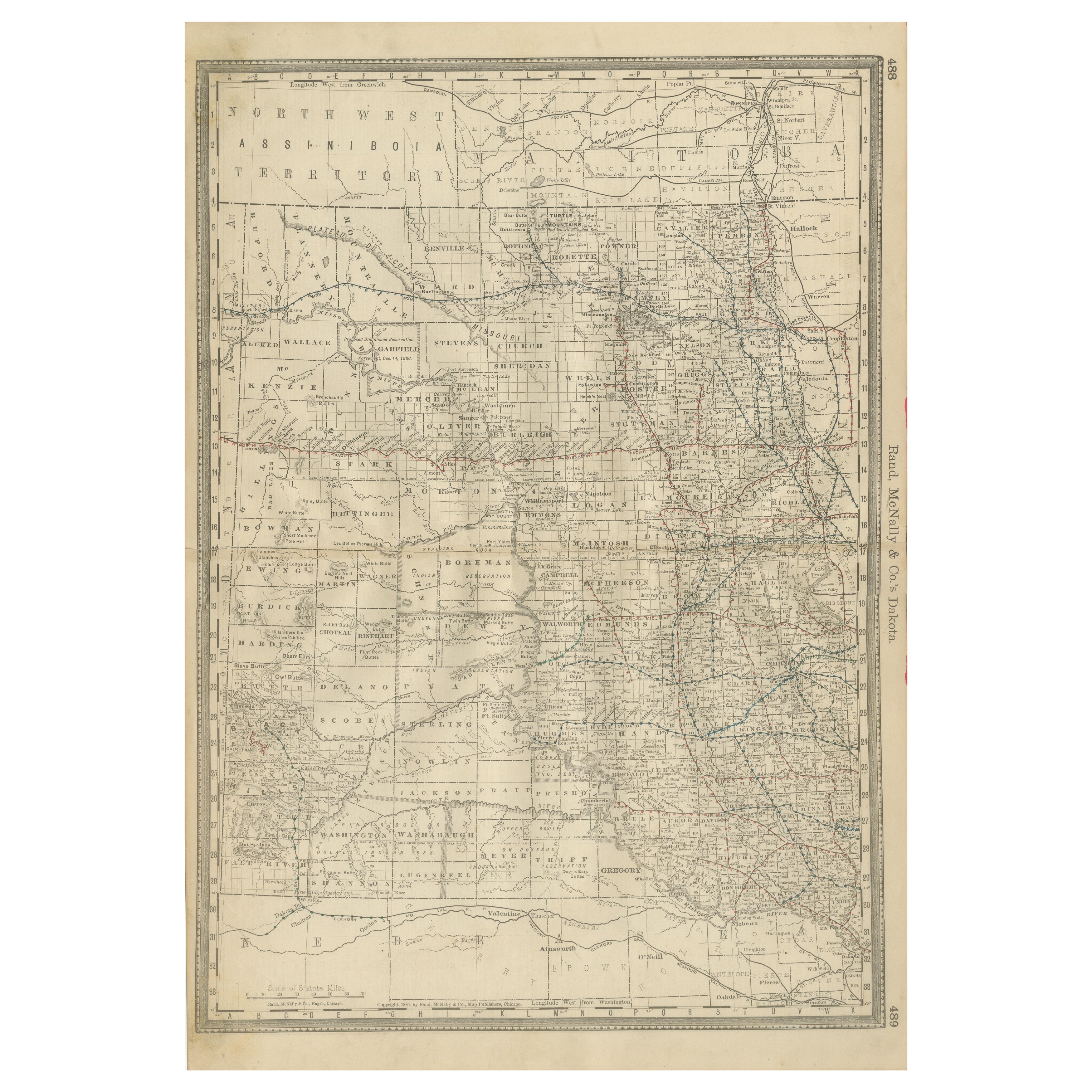
Dakota Territory Railroad Map 1888 – Rand McNally Antique Lithograph
Located in Langweer, NL
Antique Map of Dakota Territory – Rand McNally Railroad Map, 1888
This detailed 1888 map of Dakota by Rand, McNally & Co. captures the region in the final year before its division i...
Category
Antique Late 19th Century American Maps
Materials
Paper
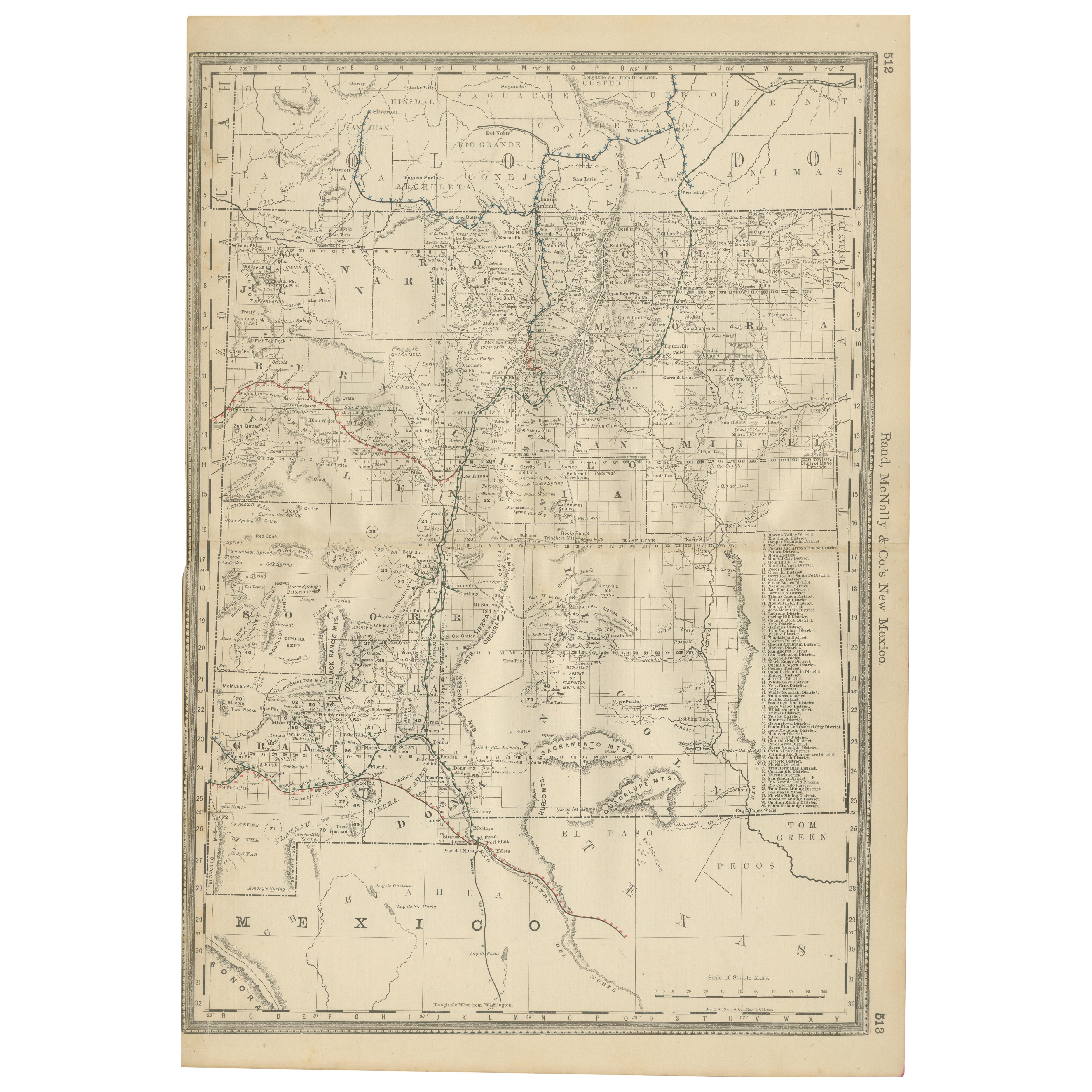
1888 New Mexico Map – Railroads, Counties
The Land of Enchantment
Located in Langweer, NL
Antique Map of New Mexico – Railroads, Counties & Frontier Settlements, 1888
This antique engraved map depicts the Territory of New Mexico in 1888, engraved and published by Rand, M...
Category
Antique Late 19th Century American Maps
Materials
Paper

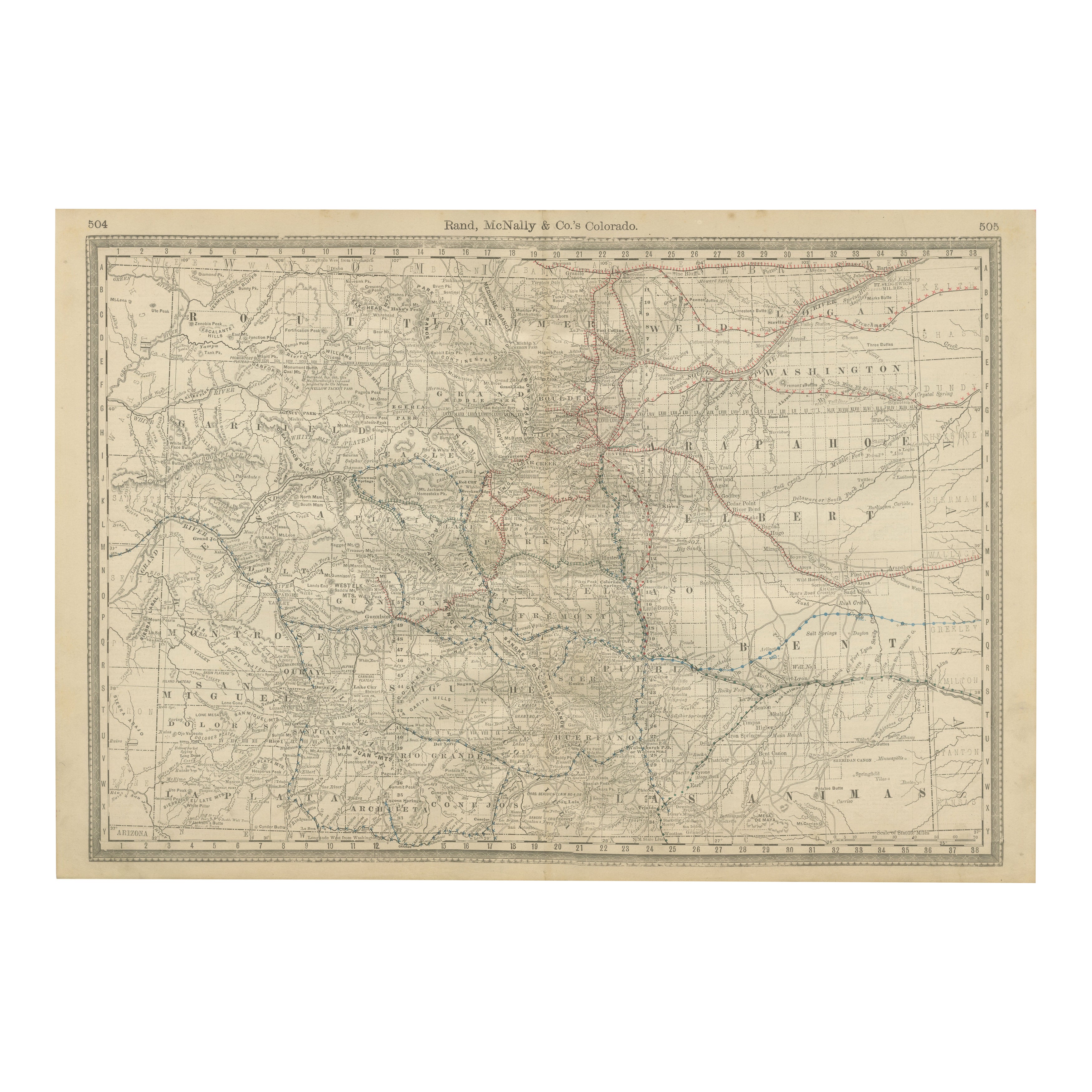
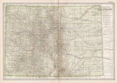
1888 Colorado Map – The Centennial State’s Railroads, Mines
Counties
Located in Langweer, NL
Antique Map of Colorado – Railroads, Mining Towns & Counties, 1888
This antique engraved map depicts the state of Colorado in 1888, published by Rand, McNally & Co. in Chicago for t...
Category
Antique Late 19th Century American Maps
Materials
Paper
You May Also Like
Montana. USA. Century Atlas state antique vintage map
Located in Melbourne, Victoria
'The Century Atlas. Montana'
Original antique map, 1903.
Central fold as issued. Map name and number printed on the reverse corners.
Sheet 29.5cm by 40cm.
Category
Early 20th Century Victorian More Prints
Materials
Lithograph
Large Original Antique Map of Utah, USA, 1894
By Rand McNally
Co.
Located in St Annes, Lancashire
Fabulous map of Utah
Original color
By Rand, McNally & Co.
Published, 1894
Unframed
Free shipping.
Category
Antique 1890s American Maps
Materials
Paper

Original Antique Map of the American State of Colorado, 1903
Located in St Annes, Lancashire
Antique map of Colorado
Published By A & C Black. 1903
Original colour
Good condition
Unframed.
Free shipping
Category
Antique Early 1900s English Maps
Materials
Paper

Original Antique Map of the American State of Idaho
Wyoming, 1903
Located in St Annes, Lancashire
Antique map of Idaho and Wyoming
Published By A & C Black. 1903
Original colour
Good condition
Unframed.
Free shipping
Category
Antique Early 1900s English Maps
Materials
Paper

Colorado. USA. Century Atlas state antique vintage map
Located in Melbourne, Victoria
'The Century Atlas. Colorado.'
Original antique map, 1903.
Central fold as issued. Map name and number printed on the reverse corners.
Sheet 29.5cm by 40cm.
Category
Early 20th Century Victorian More Prints
Materials
Lithograph
Original 1917 Railroad Map of Washington State railway map
Located in Spokane, WA
This is an Original Lithograph Vintage Railroad Map of Washington State; it is not a reproduction.
“Railroad Map of Washington, 1917, The Public Servi...
Category
1910s Academic Landscape Prints
Materials
Lithograph
$680 Sale Price
20% Off