Items Similar to Antique Zoological Map, 1843


Want more images or videos?
Request additional images or videos from the seller
1 of 6
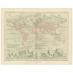
Antique Zoological Map, 1843
$211.38
$264.2220% Off
£156.57
£195.7220% Off
€176
€22020% Off
CA$289.21
CA$361.5220% Off
A$314.69
A$393.3620% Off
CHF 166.62
CHF 208.2820% Off
MX$3,785.91
MX$4,732.3920% Off
NOK 2,115.75
NOK 2,644.6820% Off
SEK 1,935.76
SEK 2,419.7020% Off
DKK 1,341.26
DKK 1,676.5820% Off
About the Item
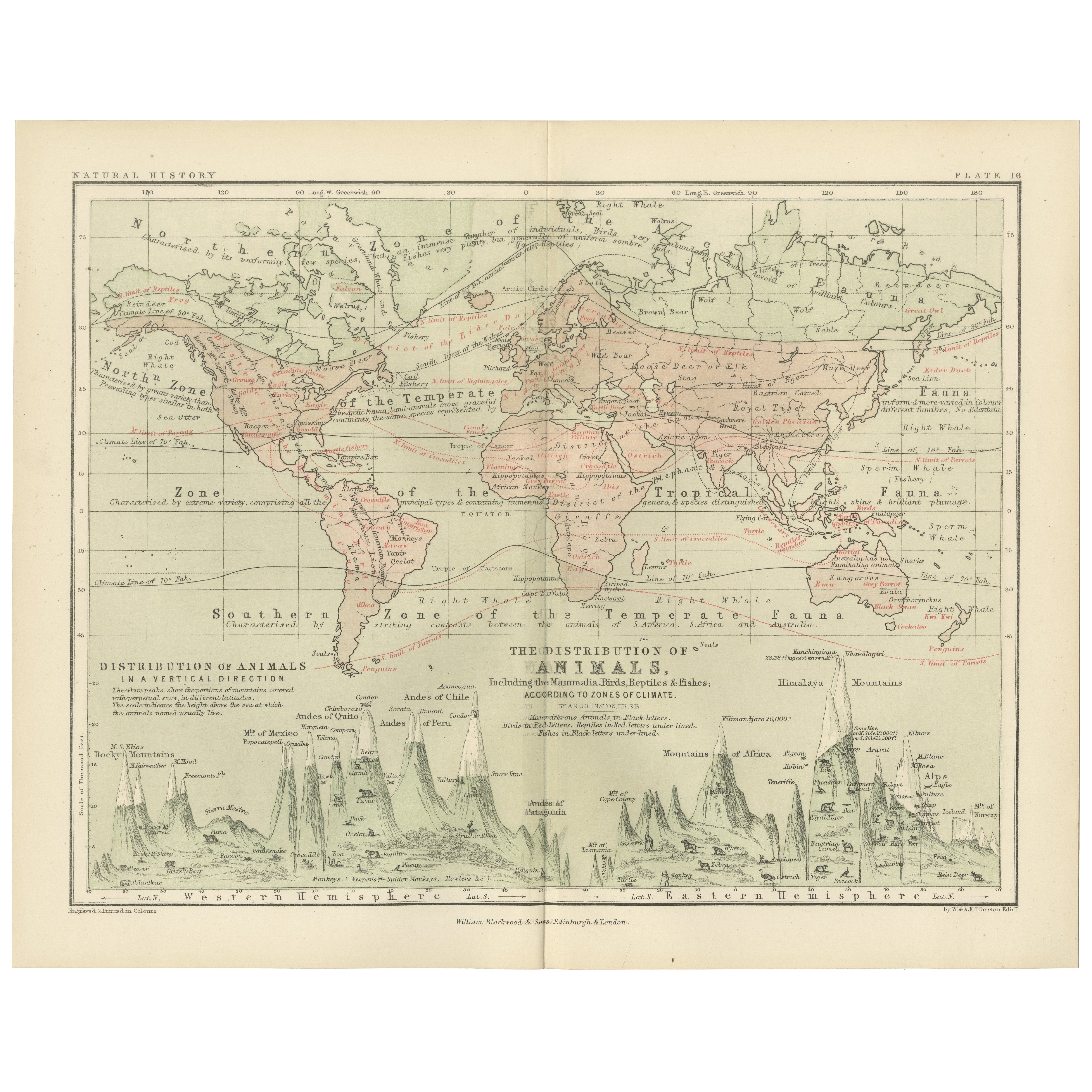
Two antique world maps on one sheet. The upper map shows the distribution of animals over the world. The lower map shows the distribution of birds
reptiles over the world. Originates from 'Geographical Diagrams
Artists and Engravers: Published by J. Reynolds, London.
Condition: Good, general age-related toning. Please study image carefully.
Date: 1843
Overall size: 22.7 x 28.5 cm.
Image size: 19.5 x 26.5 cm.
We sell original antique maps to collectors, historians, educators and interior decorators all over the world. Our collection includes a wide range of authentic antique maps from the 16th to the 20th centuries. Buying and collecting antique maps is a tradition that goes back hundreds of years. Antique maps have proved a richly rewarding investment over the past decade, thanks to a growing appreciation of their unique historical appeal. Today the decorative qualities of antique maps are widely recognized by interior designers who appreciate their beauty and design flexibility. Depending on the individual map, presentation, and context, a rare or antique map can be modern, traditional, abstract, figurative, serious or whimsical. We offer a wide range of authentic antique maps for any budget.
- Dimensions:Height: 11.23 in (28.5 cm)Width: 8.94 in (22.7 cm)Depth: 0 in (0.01 mm)
- Materials and Techniques:
- Period:
- Date of Manufacture:1843
- Condition:Condition: Good, general age-related toning. Please study image carefully.
- Seller Location:Langweer, NL
- Reference Number:Seller: BG-08143-31stDibs: LU3054329626102
About the Seller
5.0
Recognized Seller
These prestigious sellers are industry leaders and represent the highest echelon for item quality and design.
Platinum Seller
Premium sellers with a 4.7+ rating and 24-hour response times
Established in 2009
1stDibs seller since 2017
2,816 sales on 1stDibs
Typical response time: 1 hour
- ShippingRetrieving quote...Shipping from: Langweer, Netherlands
- Return Policy
More From This Seller
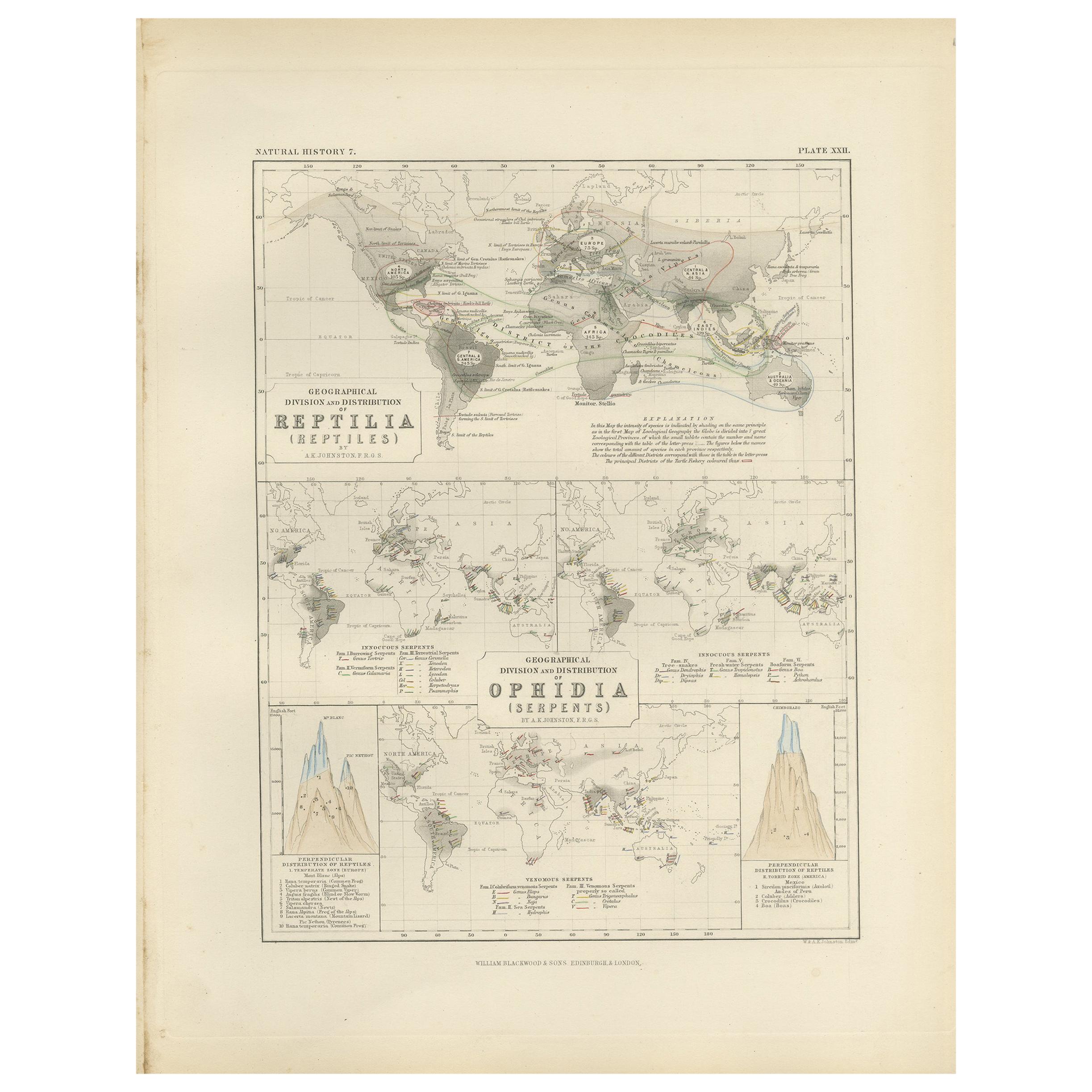
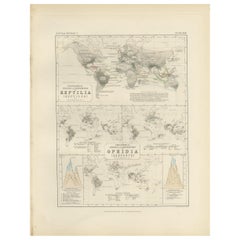
View AllAntique Map Showing the Division and Distribution of Reptiles by Johnston
1850
Located in Langweer, NL
Antique map titled 'Geographical division and distribution of reptilia and ophidia. Original antique map showing the geographical division and distribution of reptiles and serpents. ...
Category
Antique Mid-19th Century Maps
Materials
Paper
$192 Sale Price
20% Off
Antique Map Showing the Division and Distribution of Mammals by Johnston
1850
Located in Langweer, NL
Antique map titled 'Geographical division and distribution of mammiferous animals of the orders rodentia and ruminantia over the globe'. Original antique map showing geographical div...
Category
Antique Mid-19th Century Maps
Materials
Paper

$192 Sale Price
20% Off
Antique Map Showing the Division and Distribution of Mammals by Johnston
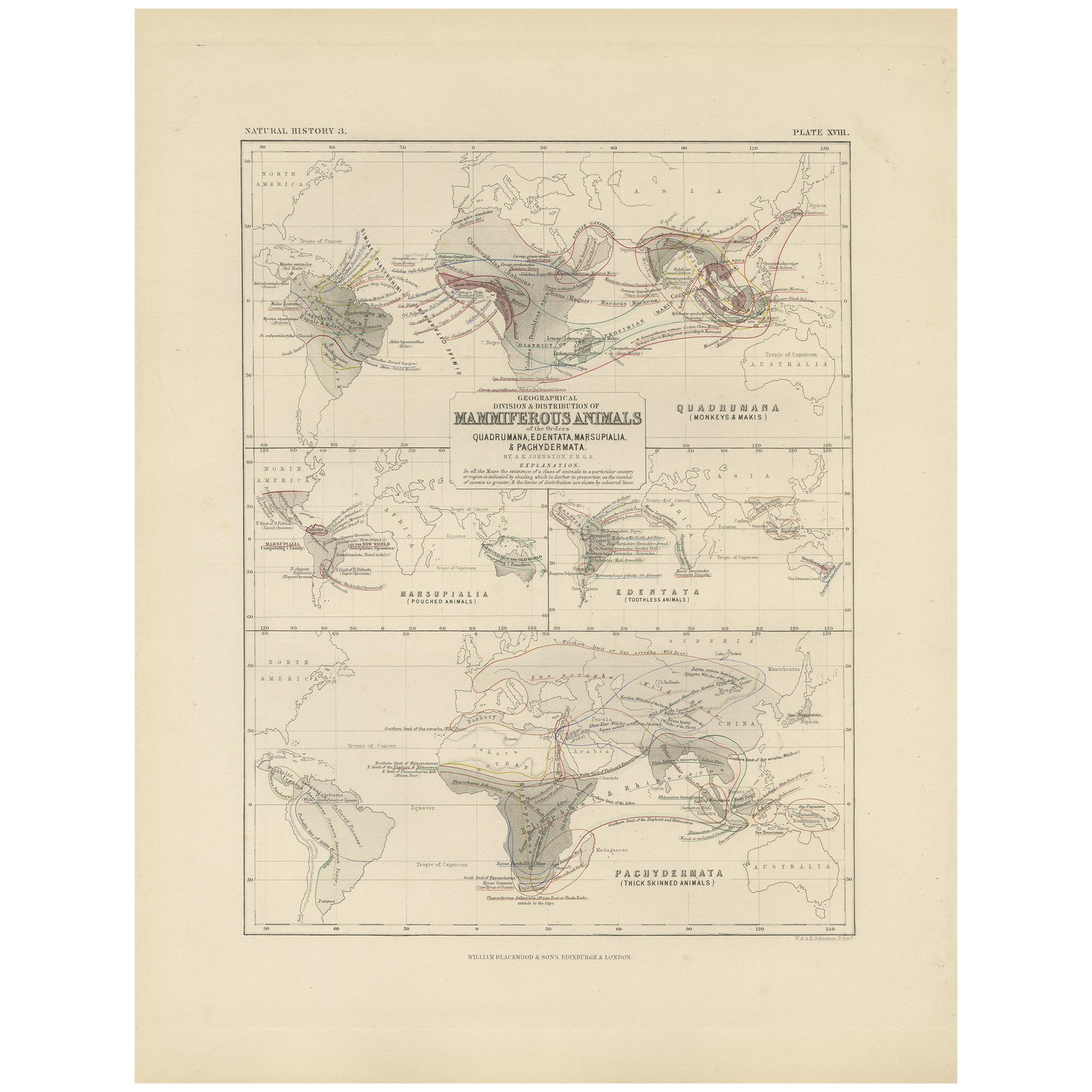
1850
Located in Langweer, NL
Antique map titled 'Geographical division and distribution of mammiferous animals of the orders quadrumana, edentata, marsupialia & pachydermata'. Original antique map showing the ge...
Category
Antique Mid-19th Century Maps
Materials
Paper
$156 Sale Price
35% Off
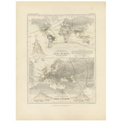
Animal Distribution Map by A.K. Johnston – Fauna by Climate Zones 1852
Located in Langweer, NL
Animal Distribution Map by A.K. Johnston – Fauna by Climate Zones 1852
This beautifully engraved chart titled "The Distribution of Animals Including the Mammalia, Birds, Reptiles & ...
Category
Antique Mid-19th Century Scottish Prints
Materials
Paper
Antique Map of the World Showing the Distribution of Plants and Minerals, 1872
Located in Langweer, NL
Antique map titled 'Johnson's World showing the distribution of the Characteristic Forest Trees (..)'. Original world map showing the distribution o...
Category
Antique Late 19th Century Maps
Materials
Paper

$192 Sale Price
20% Off
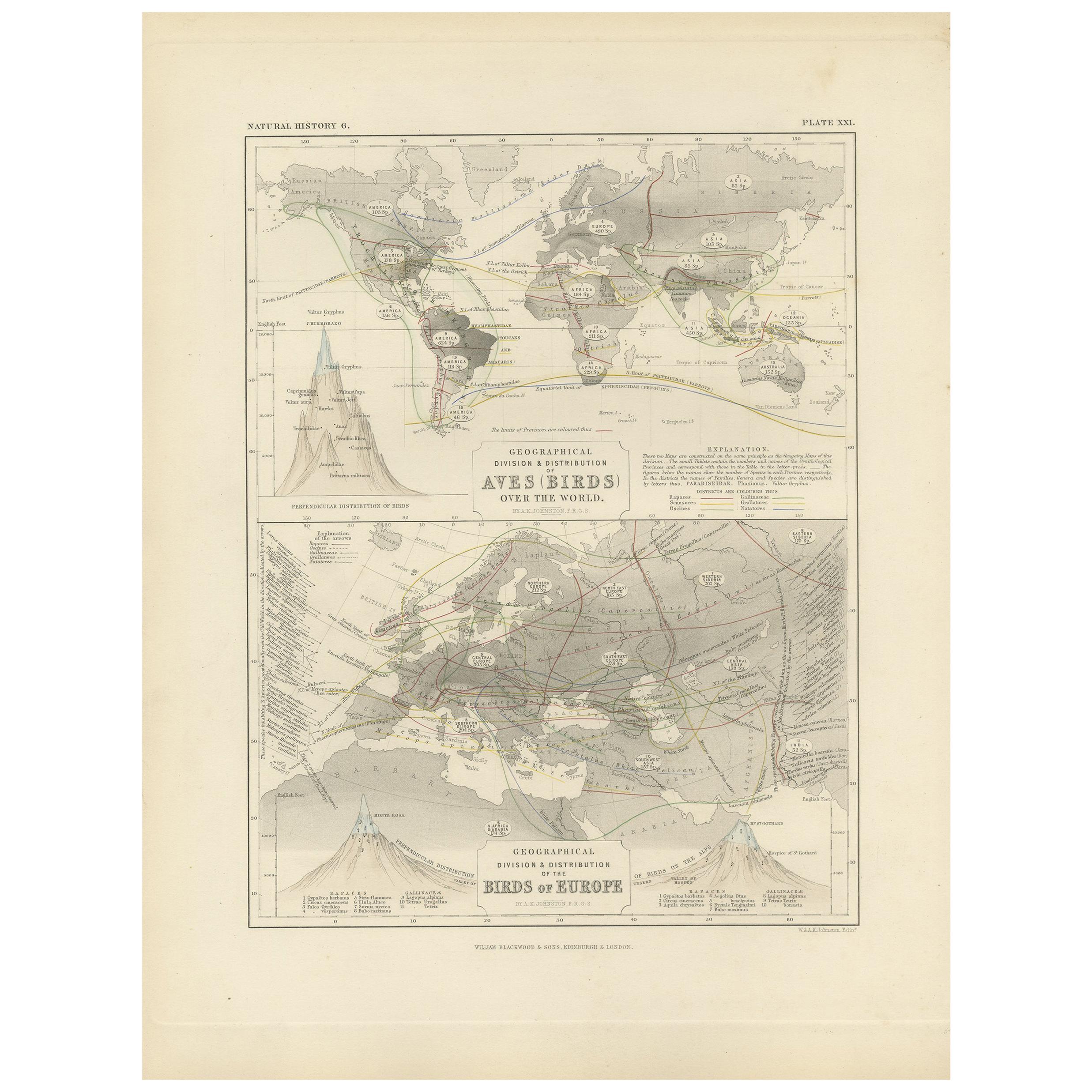
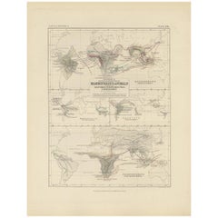
Antique Map Showing the Division and Distribution of Birds by Johnston
1850
Located in Langweer, NL
Antique map titled 'Geographical division and distribution of birds over the world and birds of Europe'. Original antique map showing the geographical ...
Category
Antique Mid-19th Century Maps
Materials
Paper
$192 Sale Price
20% Off
You May Also Like
Original Antique Map of The World by Thomas Clerk, 1817
Located in St Annes, Lancashire
Great map of The Eastern and Western Hemispheres
On 2 sheets
Copper-plate engraving
Drawn and engraved by Thomas Clerk, Edinburgh.
Published by Mackenzie And Dent, 1817
...
Category
Antique 1810s English Maps
Materials
Paper

1864 Original illustrated planisphere - World Map - Geography
Located in PARIS, FR
Immerse yourself in the epic journey of the past with the Illustrated Historical Planisphere of 1864 by Charpentier! 🗺️ This cartographic treasure transports you through the intrica...
Category
1860s Prints and Multiples
Materials
Linen, Paper, Lithograph

Large Original Antique Map of The World, Fullarton, C.1870
Located in St Annes, Lancashire
Great map of the World. Showing both hemispheres
From the celebrated Royal Illustrated Atlas
Lithograph. Original color.
Published by Fullarton, Edinburgh, C.1870
Unframed.
Rep...
Category
Antique 1870s Scottish Maps
Materials
Paper

Original Antique Map of The World by Dower, circa 1835
Located in St Annes, Lancashire
Nice map of the World
Drawn and engraved by J.Dower
Published by Orr & Smith. C.1835
Unframed.
Free shipping
Category
Antique 1830s English Maps
Materials
Paper

Antique 1803 Italian Map of Asia Including China Indoneseia India
Located in Amsterdam, Noord Holland
Antique 1803 Italian Map of Asia Including China Indoneseia India
Very nice map of Asia. 1803.
Additional information:
Type: Map
Country of Manufacturing: Europe
Period: 19th centu...
Category
Antique 19th Century European Maps
Materials
Paper

$438 Sale Price
39% Off
Antique Map of Eastern Hemisphere from the collection of Thierry Despont
Located in New York, NY
Designed by Enrico Bonetti (E. Bonatti) and published by Francesco Vallardi Editore. Based on an earlier map by Evangelista Azzi (Ev. Azzi). Labeled as such at bottom edge of map.
T...
Category
Antique Late 19th Century Italian Maps
Materials
Canvas, Wood

More Ways To Browse
James Cook Map
Kentucky Antiques
Map Of Mexican California
Montreal Map
Mughal Map
Napoleon Map
Rand Mcnally Vintage Maps
Tunisia Antique Map
Used Office Furniture Rhode Island
Antique Chesapeake Bay Map
Antique Copper Australia
Antique Furniture Pondicherry
Antique Map Of Cornwall
Antique Maps Dublin
Antique Maps Of Malta
Antique Saudi Arabia
Armenia Map
Cambodia Antique Map