Items Similar to Asia in the Age of Exploration – Antique Map by Rigobert Bonne, c.1780


Want more images or videos?
Request additional images or videos from the seller
1 of 10
Asia in the Age of Exploration – Antique Map by Rigobert Bonne, c.1780
$432.68
£320.50
€360
CA$591.90
A$645.14
CHF 341.08
MX$7,766.23
NOK 4,329.13
SEK 3,968.93
DKK 2,743
About the Item
Asia in the Age of Exploration – Antique Map by Rigobert Bonne, c.1780
DESCRIPTION
This engraved map of Asia reflects European geographic understanding during the late Enlightenment. Produced by Rigobert Bonne, it shows China, India, Southeast Asia, and the Indonesian archipelago with strong coastal accuracy, while Central Asia retains historic regional divisions. Trade routes, river systems, and key cities reflect Europe’s growing commercial and diplomatic engagement with Asia. Longitude measured from Paris reinforces its scientific context. The map’s restrained style favors clarity over ornament, making it a valuable reference image and an elegant display piece documenting Asia before 19th-century imperial cartography.
KEYWORDS
Asia map, Silk Road regions, China India trade routes, East Indies, Japan Philippines, spice trade geography
CONDITION REPORT
Uniform age toning. Central fold as issued. Minor marginal wear and faint spotting.
FRAMING TIPS
Wide mat recommended; walnut or ebonized frame adds contrast and depth.
Technique: Engraving
Maker: Rigobert Bonne, France, circa 1780
- Dimensions:Height: 10.24 in (26 cm)Width: 16.15 in (41 cm)Depth: 0.01 in (0.2 mm)
- Materials and Techniques:Paper,Engraved
- Place of Origin:
- Period:
- Date of Manufacture:Circa 1780
- Condition:Uniform age toning. Central fold as issued. Minor marginal wear and faint spotting.
- Seller Location:Langweer, NL
- Reference Number:Seller: BG-14105-41stDibs: LU3054348107812
About the Seller
5.0
Recognized Seller
These prestigious sellers are industry leaders and represent the highest echelon for item quality and design.
Platinum Seller
Premium sellers with a 4.7+ rating and 24-hour response times
Established in 2009
1stDibs seller since 2017
2,813 sales on 1stDibs
Typical response time: 1 hour
- ShippingRetrieving quote...Shipping from: Langweer, Netherlands
- Return Policy
More From This Seller
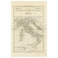
View AllItaly in the Age of Antiquity – Rigobert Bonne French Map c.1780
Located in Langweer, NL
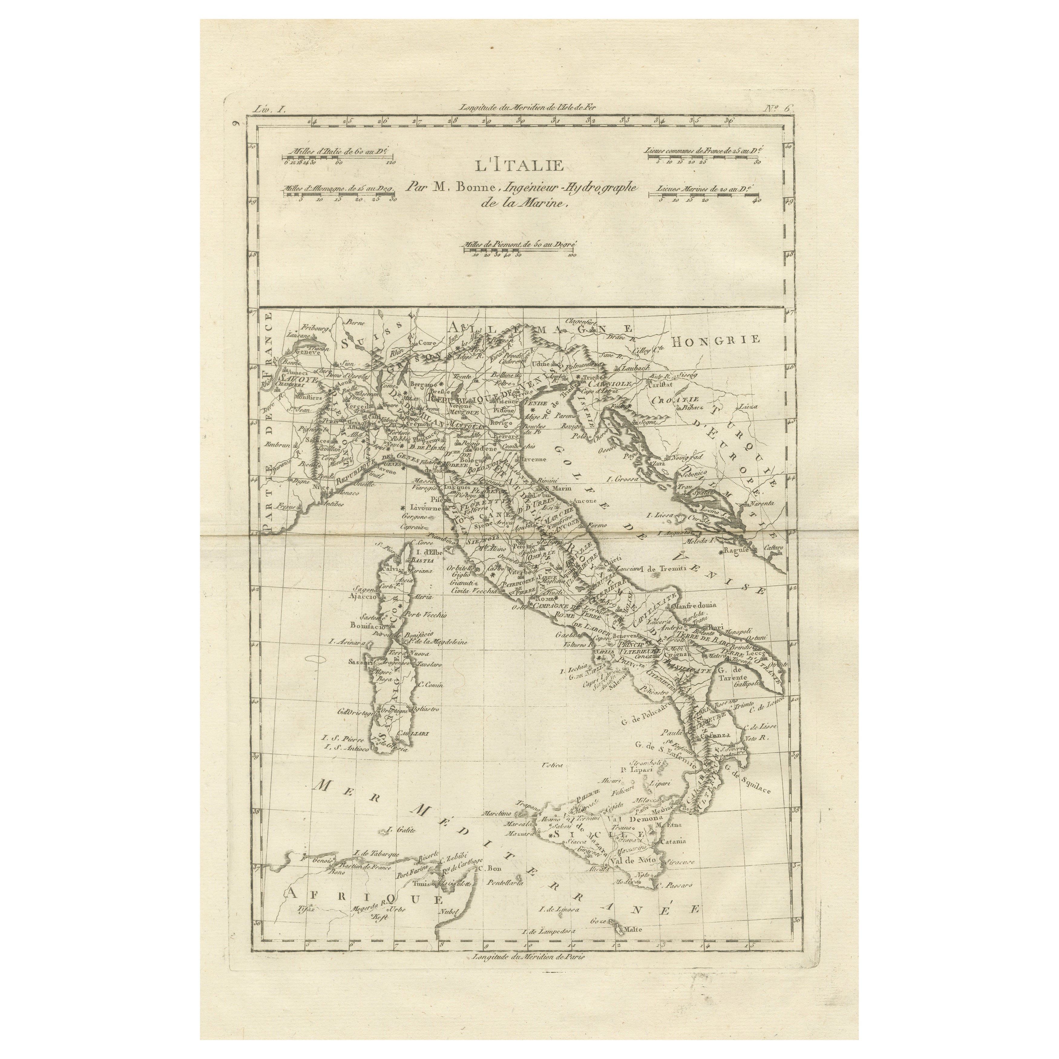
Italy Map by Rigobert Bonne – Classical Peninsula c.1780
DESCRIPTION
This engraved map focuses on the Italian peninsula before national unification. Compiled by Rigobert Bonne, it s...
Category
Antique Late 18th Century French Maps
Materials
Paper
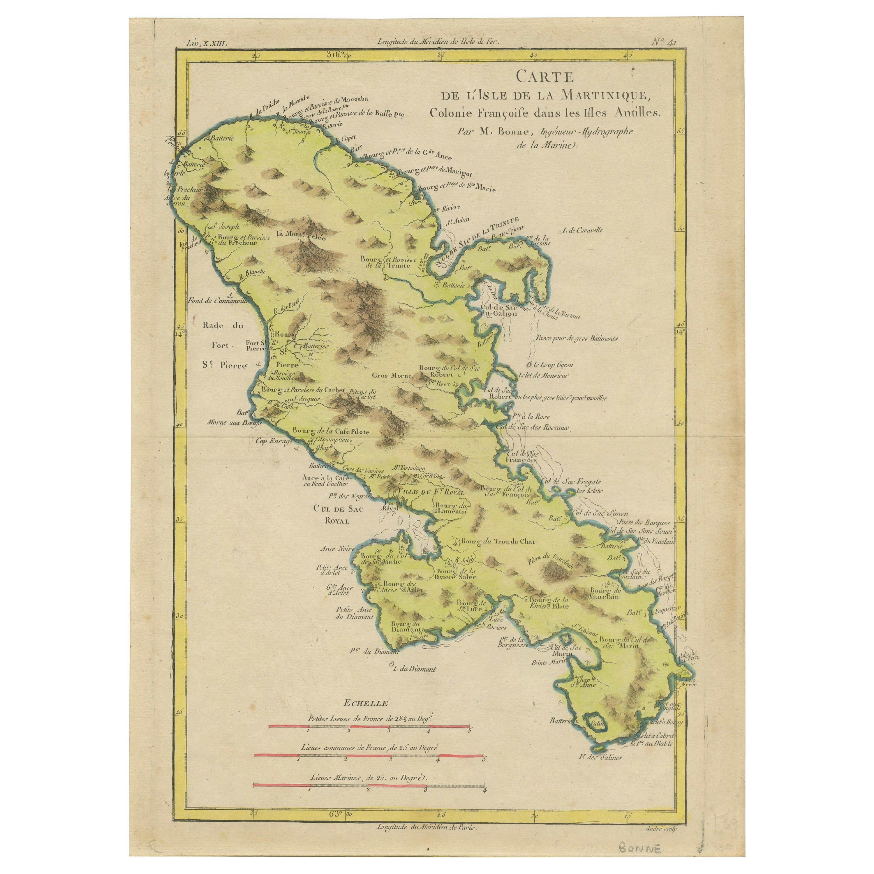
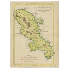
Antique Map of Martinique by Rigobert Bonne, Circa 1780
Located in Langweer, NL
Antique map titled 'Carte de l'Isle de la Martinique Colonie Francoise dans les Isles Antilles'. Detailed map of the French Island of Martinique.
Many towns and harbours, anchor pl...
Category
Antique 18th Century French Maps
Materials
Paper
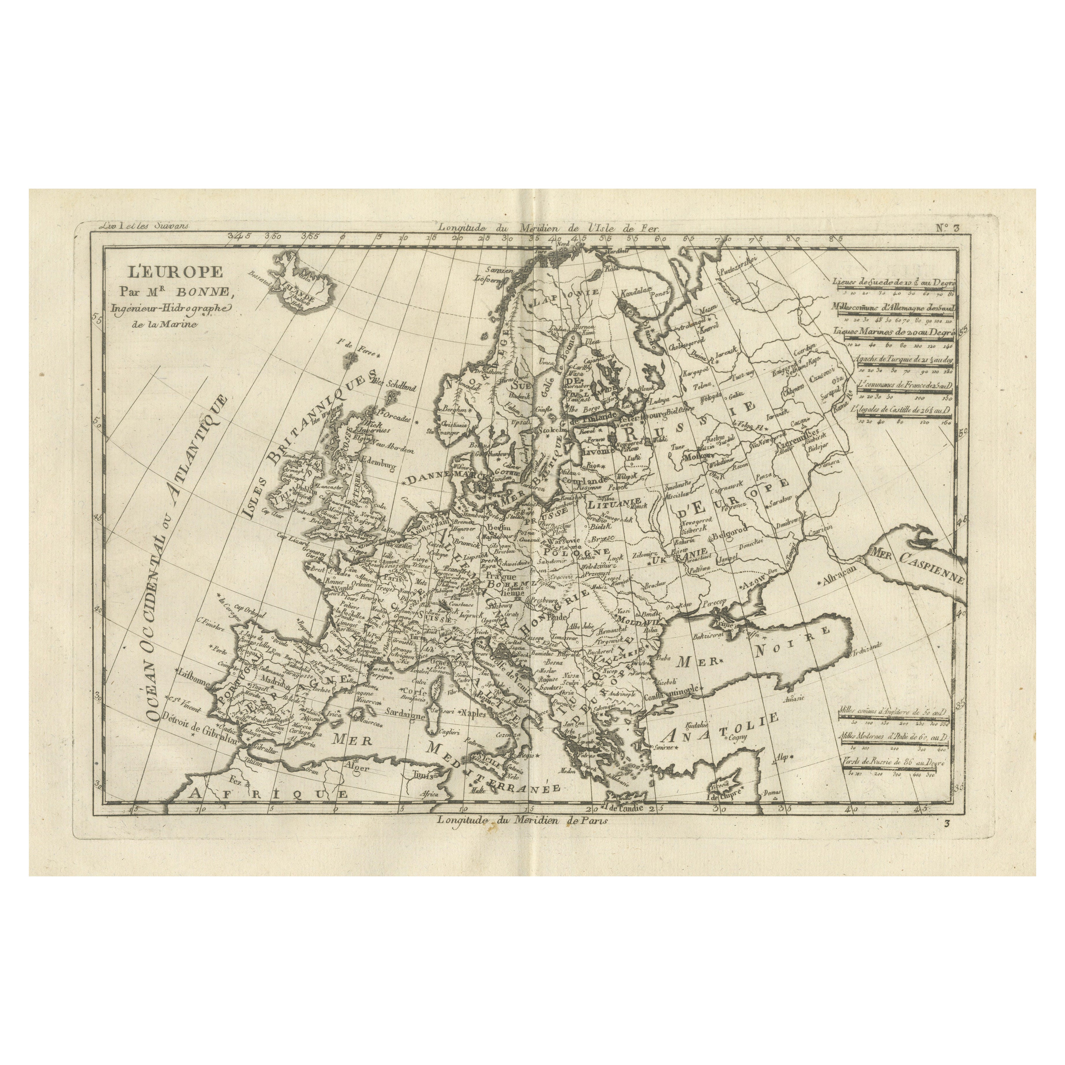
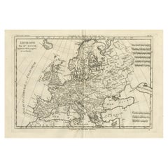
Europe Map by Rigobert Bonne – Enlightenment Cartography c.1780
Located in Langweer, NL
Europe Map by Rigobert Bonne – Enlightenment Cartography c.1780
DESCRIPTION
This detailed map of Europe illustrates political and geographic divisions prior to the Napoleonic era. C...
Category
Antique Late 18th Century French Maps
Materials
Paper
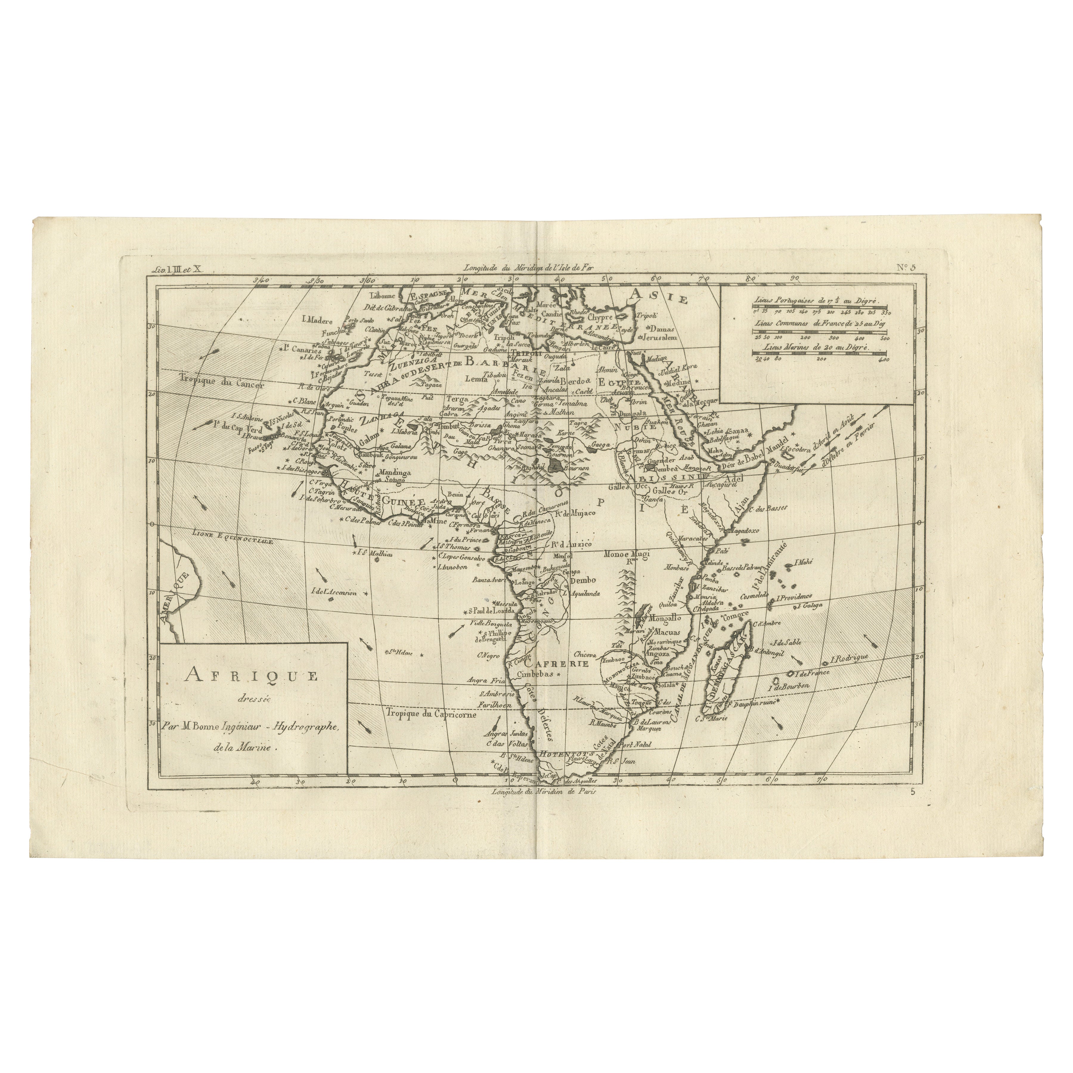
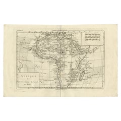
Africa Map by Rigobert Bonne – Pre-Colonial Geography c.1780
Located in Langweer, NL
Africa Map by Rigobert Bonne – Pre-Colonial Geography c.1780
DESCRIPTION
This map of Africa captures European geographic knowledge prior to large-scale colonial penetration. Engrave...
Category
Antique Late 18th Century French Maps
Materials
Paper
Map of Virgin Islands and Lesser Antilles by Rigobert Bonne, c. 1780
Located in Langweer, NL
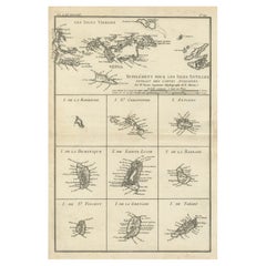
Map of Virgin Islands and Lesser Antilles by Rigobert Bonne, c. 1780
This fine antique map is titled 'Supplément pour les Isles Antilles, extrait des cartes angloises' and was engraved by Rigobert Bonne, Ingénieur-Hydrographe de la Marine, around 1780. It depicts:
Upper half:
* The Virgin Islands (*Les Isles Vierges*), including:
* St. Thomas
* St. John
* Tortola
* Virgin Gorda
* Jost Van Dyke
* Surrounding smaller islands and passages.
* Parts of Puerto Rico visible left.
Lower half:
Nine inset maps of individual Caribbean islands with coastal details:
1. I. de la Barboude (Barbuda)
2. I. St. Christophe (St. Kitts)
3. I. Antigoa (Antigua)
4. I. de la Dominique (Dominica)
5. I. de Sainte Lucie (St. Lucia)
6. I. de la Barbade (Barbados)
7. I. de St. Vincent
8. I. de la Grenade (Grenada)
9. I. de Tabago (Tobago)
Features:
* Coastal names, bays, capes, and harbours noted.
* Fine clear engraving typical of Bonne’s atlases for maritime use.
* Scale bar with French lieues marines.
Engraver: Rigobert Bonne
Date: circa 1780
Published in: Atlas Encyclopédique
Condition:
Good dark impression on laid paper with wide margins. Some slight toning along centre fold and faint edge wear consistent with age. Original platemark visible.
Framing suggestions:
Display with other Bonne Caribbean or West Indies maps in a travel, history, or colonial themed wall. Ideal floated in a black or walnut wood frame with archival matting to preserve the crisp engraving.
Keywords:
Rigobert Bonne Caribbean maps...
Category
Antique 1780s French Maps
Materials
Paper
Martinique Map by Rigobert Bonne – French Antique Map, c.1768
Located in Langweer, NL
Map of Martinique by Rigobert Bonne, circa 1768
This is a detailed antique map of Martinique titled “Isle de la Martinique,” engraved by Rigobert Bonne around 1768 for the Atlas Encyclopédique. Bonne, a renowned French hydrographer and successor to Bellin, is celebrated for his scientifically precise and elegantly engraved maps.
The map shows Martinique with its mountainous interior, rivers, and settlements labelled, including Fort Royal, Fort St. Pierre, Le Marin, and Le Prêcheur. Coastal features, bays, and capes are marked, along with anchorages important for maritime navigation in the 18th century. The depiction includes relief shown pictorially, characteristic of Bonne’s cartographic style, enhancing both geographic understanding and aesthetic appeal.
This copperplate engraving retains original hand colouring outlining the coastlines in delicate blue and brown tones, typical for the period. It served as a key reference for scholars, navigators, and colonial administrators during France’s colonial presence in the Caribbean.
Condition:
Good condition overall. A strong impression with bright, original hand-colour outlines. General age toning, faint offsetting, and a vertical fold as issued in the atlas. Margins ample all around for framing.
Framing suggestions:
This historic Caribbean map...
Category
Antique 1760s French Maps
Materials
Paper

You May Also Like
Original Antique Map of South America. C.1780
Located in St Annes, Lancashire
Great map of South America
Copper-plate engraving
Published C.1780
Two small worm holes to left side of map
Unframed.
Category
Antique Early 1800s English Georgian Maps
Materials
Paper

Asia in Amsterdam: The Culture of Luxury in the Golden Age by Karina Corrigan
Located in valatie, NY
Asia in Amsterdam: The Culture of Luxury in the Golden Age by Karina Corrigan. 1st Ed hardcover exhibition catalog. Published by Peabody Essex Museum / Yale University, 2015. Hardcov...
Category
21st Century and Contemporary American Books
Materials
Paper

Super Rare Antique French Map of Chine and the Chinese Empire, 1780
Located in Amsterdam, Noord Holland
Super Rare Antique French Map of Chine and the Chinese Empire, 1780
Very nice map of Asia. 1780 Made by Bonne.
Additional information:
Type: Map
...
Category
Antique 18th Century European Maps
Materials
Paper

$438 Sale Price
50% Off
Large Original Antique Map of Asia by Sidney Hall, 1847
Located in St Annes, Lancashire
Great map of Asia
Drawn and engraved by Sidney Hall
Steel engraving
Original colour outline
Published by A & C Black. 1847
Unframed
Free shipping
Category
Antique 1840s Scottish Maps
Materials
Paper

Original Antique Map of South East Asia by Thomas Clerk, 1817
Located in St Annes, Lancashire
Great map of South East Asia
Copper-plate engraving
Drawn and engraved by Thomas Clerk, Edinburgh.
Published by Mackenzie And Dent, 1817
Unframed.
Category
Antique 1810s English Maps
Materials
Paper

Captain Cook
s Exploration of Tahiti 18th C. Hand-Colored Map by Bellin
By Jacques-Nicolas Bellin
Located in Alamo, CA
This beautiful 18th century hand-colored copper plate engraved map is entitled "Carte de l'Isle de Taiti, par le Lieutenant J. Cook" was created by Jacques Nicolas Bellin and publish...
Category
Antique Mid-18th Century French Maps
Materials
Paper

$620 Sale Price
20% Off