Items Similar to Asia Minor – Antique Map of Natolia by Ortelius, Theatrum Orbis Terrarum c.1600
Video Loading
Want more images or videos?
Request additional images or videos from the seller
1 of 12
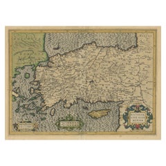
Asia Minor – Antique Map of Natolia by Ortelius, Theatrum Orbis Terrarum c.1600
$421.32
$526.6520% Off
£313.05
£391.3120% Off
€352
€44020% Off
CA$577.12
CA$721.4020% Off
A$629.60
A$78720% Off
CHF 333.93
CHF 417.4120% Off
MX$7,585.30
MX$9,481.6220% Off
NOK 4,238.20
NOK 5,297.7520% Off
SEK 3,880.19
SEK 4,850.2420% Off
DKK 2,681.49
DKK 3,351.8620% Off
About the Item
Asia Minor – Antique Map of Natolia by Ortelius, Theatrum Orbis Terrarum c.1600
This beautifully hand-colored antique map titled Natoliae quae olim Asia Minor nova descriptio presents a detailed and artistic rendering of ancient Asia Minor, known today as Anatolia in modern-day Turkey. Originally published in the monumental atlas Theatrum Orbis Terrarum by Abraham Ortelius, circa 1600, this map captures the historical region with accuracy and aesthetic finesse typical of early modern cartography.
The map spans from the Aegean coast in the west to the mountainous interior of Anatolia in the east, and includes parts of the eastern Mediterranean, notably Cyprus and nearby islands. Cities such as Ephesus, Troy, and Pergamon are clearly marked, reflecting the classical geography that Ortelius was renowned for bringing to a Renaissance audience. Though originally issued on a sheet alongside two companion maps (of Egypt and Carthage), this example has been trimmed to feature the Natolia map alone.
Ortelius’s Theatrum Orbis Terrarum, first published in 1570, is widely considered the first modern atlas. Each map was based on the best available sources of the time and beautifully engraved, typically by Frans Hogenberg, and often hand-colored. Ortelius’s historical and classical maps, such as this one, are especially admired for their blending of ancient geographical knowledge with the printing and artistic sophistication of the late 16th century.
Condition report: Very good condition for its age. Trimmed to the neatline with some minor toning and faint marginal foxing. The coloring remains vibrant and the paper strong, with no tears or repairs.
Framing tips: This map pairs beautifully with a classic gold-leaf or ebonized wood frame. A deep cream or parchment-colored mat will enhance its aged tones and highlight the subtle hand-coloring.
- Dimensions:Height: 17.41 in (44.2 cm)Width: 11.19 in (28.4 cm)Depth: 0.02 in (0.5 mm)
- Materials and Techniques:
- Place of Origin:
- Period:Early 17th Century
- Date of Manufacture:c.1600
- Condition:Very good condition for its age. Trimmed to the neatline with some minor toning and faint marginal foxing. The coloring remains vibrant and the paper strong, with no tears or repairs.
- Seller Location:Langweer, NL
- Reference Number:Seller: BG-13324-41stDibs: LU3054333591062
About the Seller
5.0
Recognized Seller
These prestigious sellers are industry leaders and represent the highest echelon for item quality and design.
Platinum Seller
Premium sellers with a 4.7+ rating and 24-hour response times
Established in 2009
1stDibs seller since 2017
2,820 sales on 1stDibs
Typical response time: 1 hour
- ShippingRetrieving quote...Shipping from: Langweer, Netherlands
- Return Policy
More From This Seller
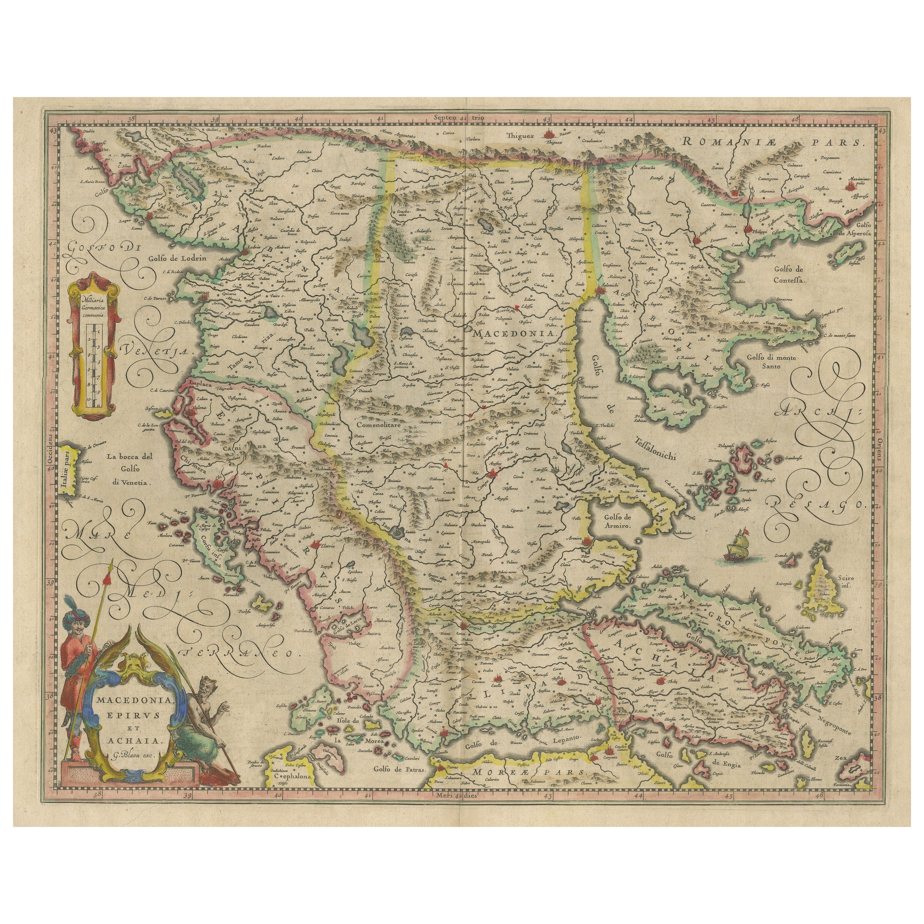
View AllAntique Map of Macedonia, Northern Greece and part of Turkey in Europe
Located in Langweer, NL
Antique map titled 'Macedonia Epirus et Achaia'. Original old map of Macedonia, northern Greece, and part of Turkey in Europe. Published by W.J. Blaeu, circa 1640.
Willem Janszoon ...
Category
Antique Mid-17th Century Maps
Materials
Paper
$766 Sale Price
20% Off
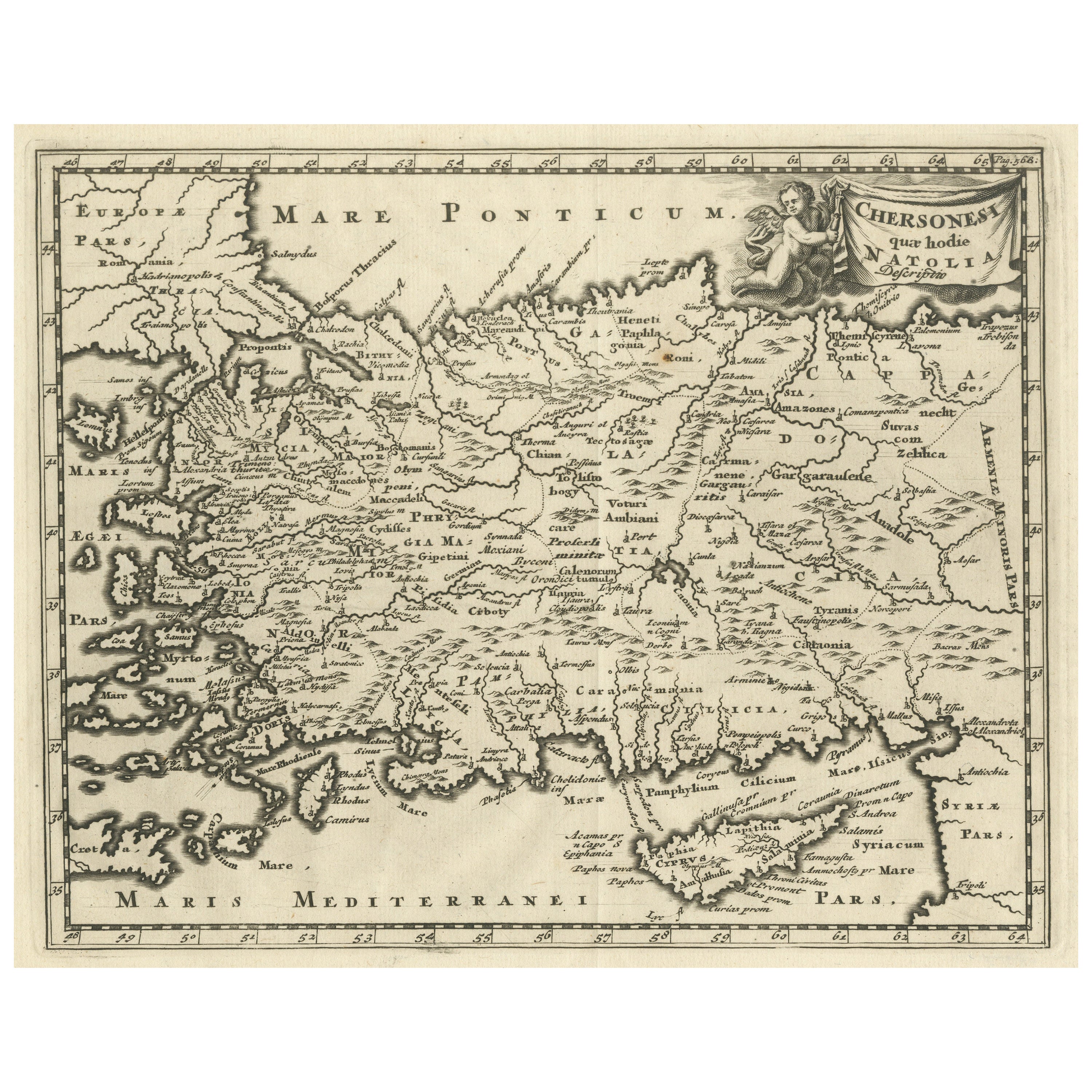
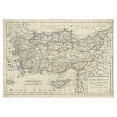
Antique Map of Asia Minor with part of the Greek Archipelago and Cyprus, 1729
Located in Langweer, NL
Antique map titled 'Chersonesi quae hodie Natolia Descriptio'. Decorative, smaller map of Asia Minor including part of the Greek Archipelago and Cyprus. The drape-style title cartouc...
Category
Antique Mid-18th Century German Maps
Materials
Paper
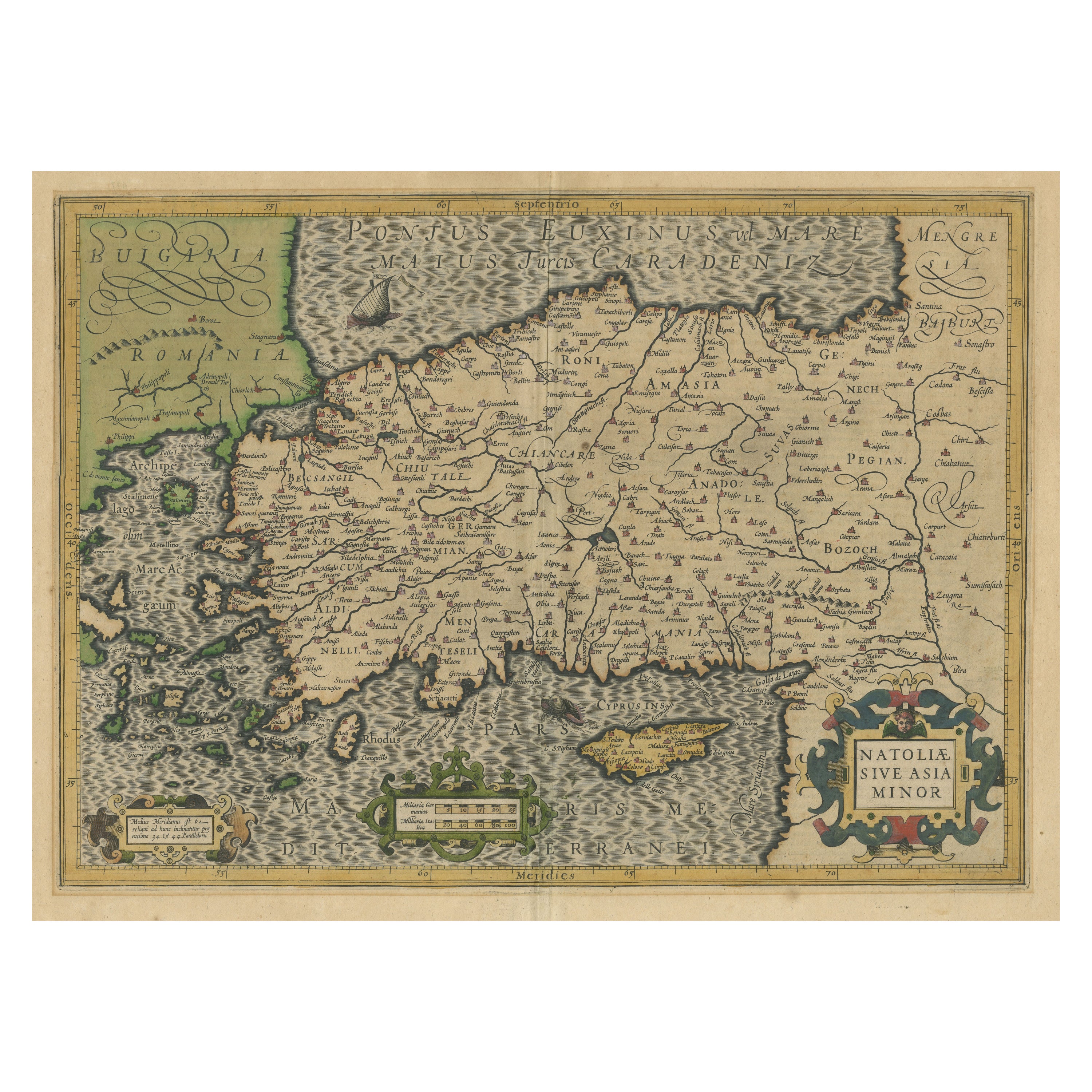
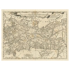
Original Antique Map of Turkey, Asia Minor and Cyprus
By Gerard Mercator
Located in Langweer, NL
Antique map titled 'Natoliae sive Asia Minor'. Original old map of Turkey, Asia Minor and Cyprus. Includes a decorative cartouches, sailing ship, sea mon...
Category
Antique Early 17th Century Maps
Materials
Paper
$804 Sale Price
20% Off
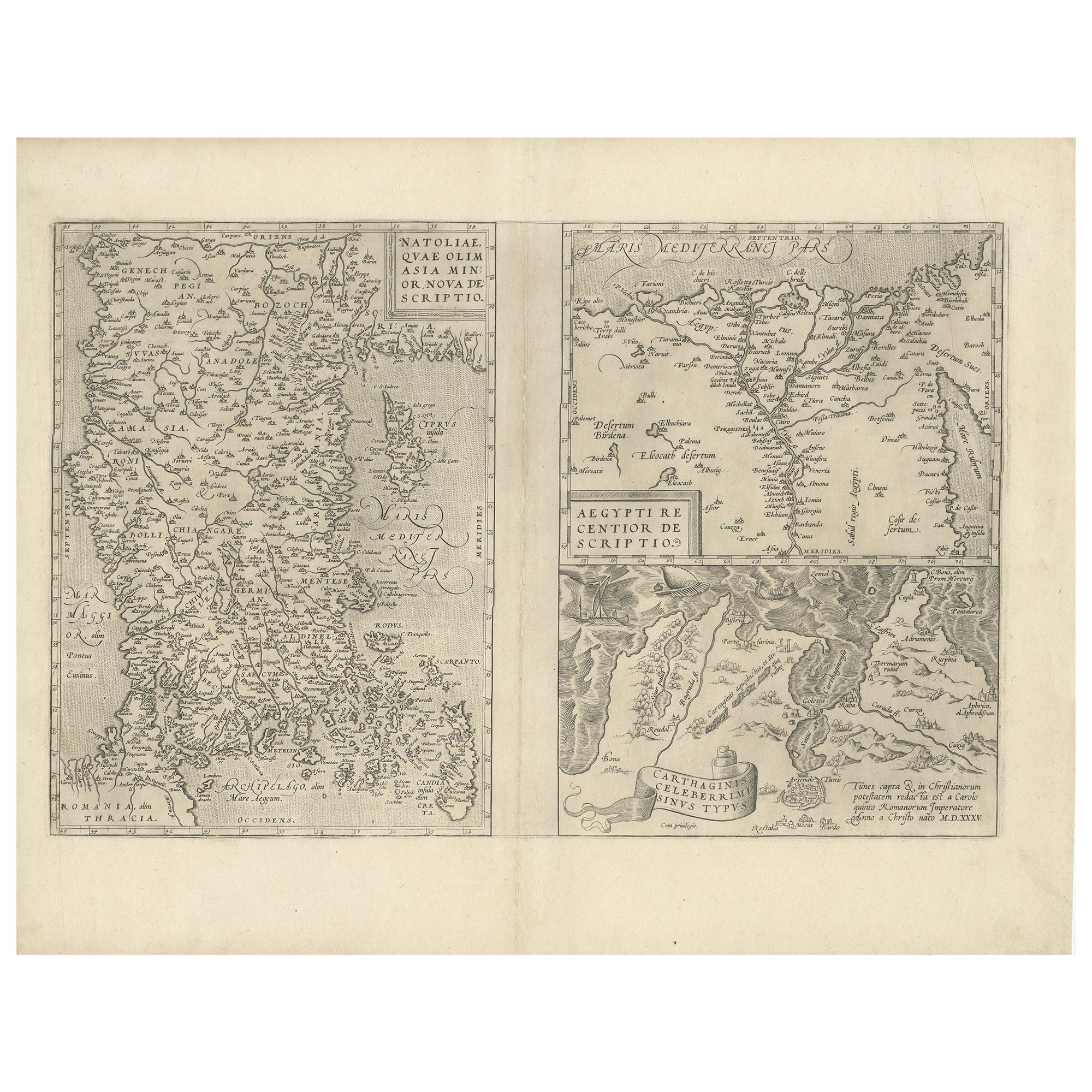
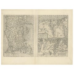
Antique Map of Asia Minor, Region of the Nile and Region of the City of Carthage
Located in Langweer, NL
Three antique maps on one sheet titled 'Natoliae quae olim Asia Minor [with] Aegypti recentior descriptio [with] Carthaginis Celeberrimisinus Typus'. The first map covers Asia Minor,...
Category
Antique 16th Century Maps
Materials
Paper
$478 Sale Price
20% Off
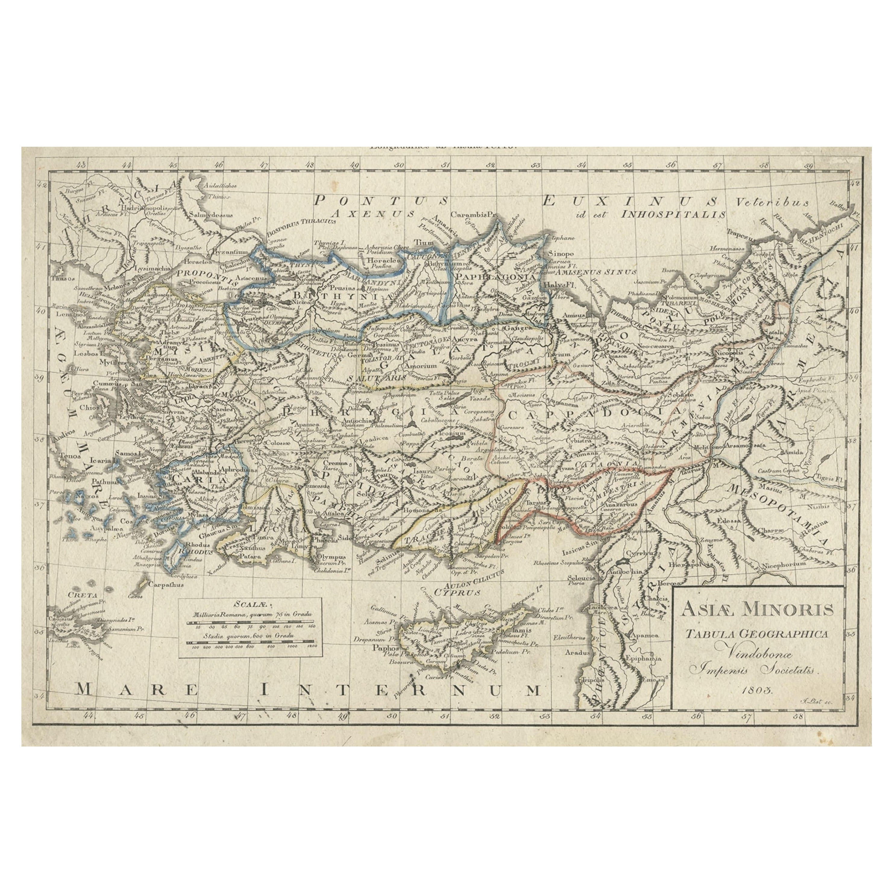
Antique Map of Asia Minor, Present-day Turkey and Cyprus, 1803
Located in Langweer, NL
Antique map titled 'Asiae Minoris Tabula Geographica'. Uncommon antique map of Asia minor, comprising most of what is present-day Turkey. Source unknown, to be determined.
Artists...
Category
Antique 19th Century Maps
Materials
Paper
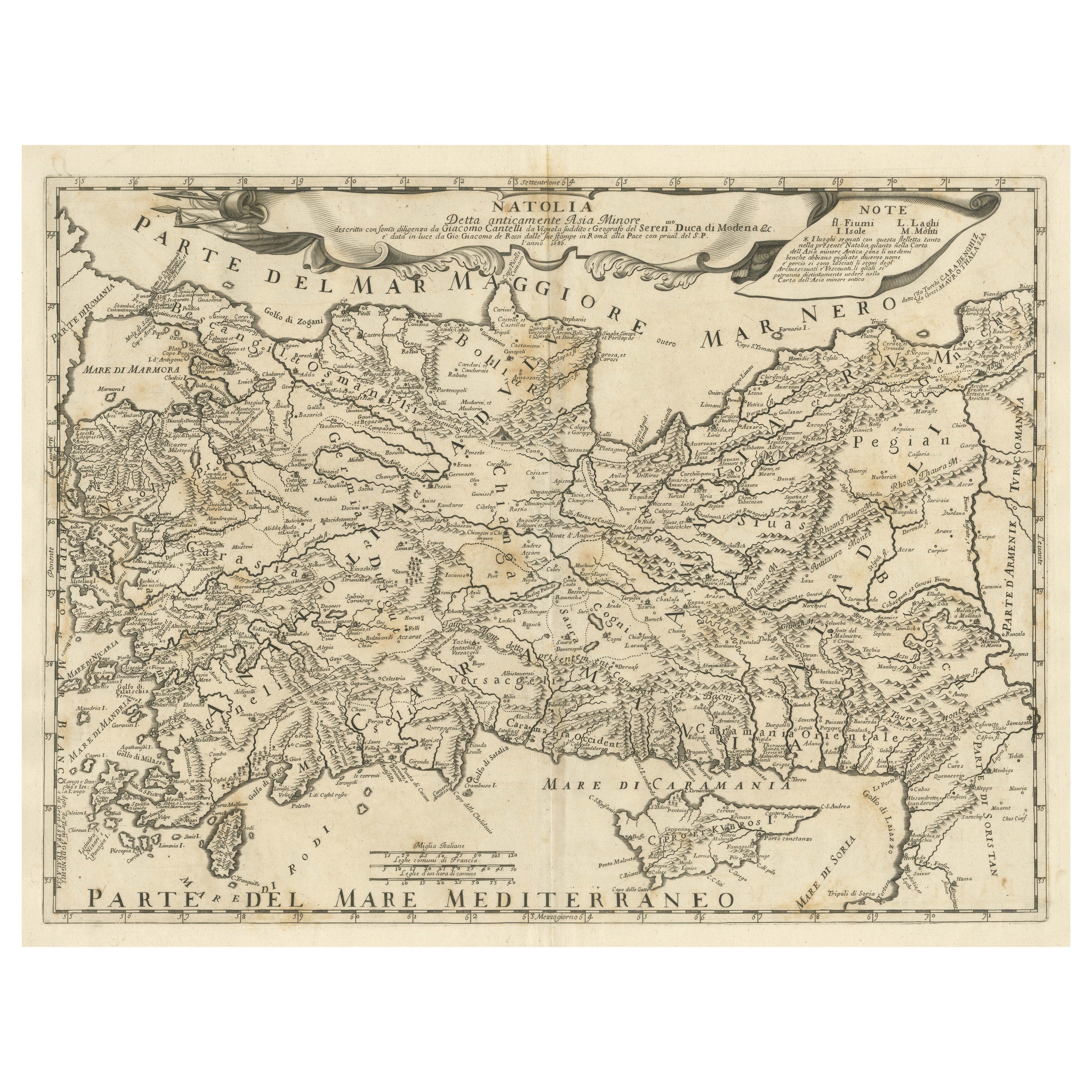
Original Italian Antique Map of Asia Minor and Cyprus and Neighboring Regions
Located in Langweer, NL
Antique map titled 'Natolia detta anticamente Asia Minor (..)'. Rare map of Asia Minor (Turkey) and Cyprus and neighboring regions. The map provides one of the most detailed and up t...
Category
Antique Late 17th Century Maps
Materials
Paper
$622 Sale Price
20% Off
You May Also Like
Antique 1803 Italian Map of Asia Including China Indoneseia India
Located in Amsterdam, Noord Holland
Antique 1803 Italian Map of Asia Including China Indoneseia India
Very nice map of Asia. 1803.
Additional information:
Type: Map
Country of Manufacturing: Europe
Period: 19th centu...
Category
Antique 19th Century European Maps
Materials
Paper

$438 Sale Price
39% Off
Southern Greece: A Large 17th C. Hand-colored Map by Sanson and Jaillot
By Nicolas Sanson
Located in Alamo, CA
This large original hand-colored copperplate engraved map of southern Greece and the Pelopponese Peninsula entitled "La Moree Et Les Isles De Zante, Cefalonie, Ste. Marie, Cerigo & C...
Category
Antique 1690s French Maps
Materials
Paper

$1,580 Sale Price
20% Off
Large Original Antique Map of Cyprus. 1894
Located in St Annes, Lancashire
Superb Antique map of Cyprus
Published Edward Stanford, Charing Cross, London 1894
Original colour
Good condition
Unframed.
Free shipping
Category
Antique 1890s English Maps
Materials
Paper

Hand-Colored 18th Century Homann Map of the Black Sea, Turkey and Asia Minor
By Johann Baptist Homann
Located in Alamo, CA
An attractive original early 18th century hand-colored map of the Black Sea and Turkey entitled "Carte de L'Asie Minevre ou de la Natolie et du Pont Evxin Tiree des Voyages et des Ob...
Category
Antique Early 18th Century German Maps
Materials
Paper

$700 Sale Price
20% Off
Greece, "Graeciae Antiquae"" A 17th Century Hand-colored Map by Sanson
By Nicolas Sanson
Located in Alamo, CA
This is an original 17th century hand colored copperplate engraved map of Greece entitled "Graeciae Antiquae Tabula Hanc Geographicam" by Nicolas d'Abbeville Sanson, engraved and pub...
Category
Antique Mid-17th Century French Maps
Materials
Paper

$1,260 Sale Price
20% Off
Original Antique Map of Ancient Greece, Achaia, Corinth, 1786
Located in St Annes, Lancashire
Great map of Ancient Greece. Showing the region of Thessaly, including Mount Olympus
Drawn by J.D. Barbie Du Bocage
Copper plate engraving by P.F Tardieu
Original hand color...
Category
Antique 1780s French Other Maps
Materials
Paper
