Items Similar to Attack Plan of Douay Fortress, France, 1710 Siege – Brussels c.1720 Map
Video Loading
Want more images or videos?
Request additional images or videos from the seller
1 of 13
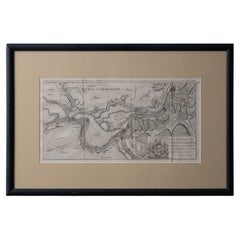
Attack Plan of Douay Fortress, France, 1710 Siege – Brussels c.1720 Map
$300.25
£222.41
€250
CA$410.82
A$447
CHF 236.68
MX$5,377.71
NOK 3,005.32
SEK 2,749.66
DKK 1,905.20
About the Item
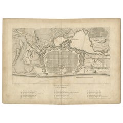
Attack Plan of Douay Fortress, France, 1710 Siege – Brussels c.1720 Map
This engraved military map shows the detailed plan of attacks on the fortress city of Douay (Douai) in northern France, titled "Plan des Attaques de la Ville de Douay" and dated to the siege operations up to June 23, 1710. It illustrates the fortification lines, bastions, ravelins, attack trenches (chemins de tranchée), batteries, and strategic positions used during the siege.
The map legend indicates:
A. la Ville (the city)
B. Attaque de la droite commandée par M. le Prince d’Anhalt (right attack commanded by Prince Anhalt)
C. Attaque de la gauche commandée par le Prince d’Orange (left attack commanded by the Prince of Orange)
D. Batterie à Canon (cannon battery)
E. Batterie à Mortiers (mortar battery)
F. Pièce de 12 envoyée sur le Glacis (12-pounder gun fired onto the glacis)
It was published in Brussels by *Eugene Henry Fricx, a well-known Flemish engraver and publisher active in the early 18th century. His maps often documented military campaigns of the War of the Spanish Succession for Dutch and allied audiences. The clear layout focuses on the geometric bastion fortifications typical of Vauban design, along with systematic approaches of siege warfare including zig-zag trenches and artillery placements.
The Siege of Douai (1710) was part of Marlborough’s campaign in northern France, capturing this strategic fortress city after several weeks of siege operations involving extensive trench networks and artillery bombardments.
Condition report:
Very good condition. Strong impression and clear detail. Light general age toning, minor foxing in margins, not affecting the printed area. Original center fold as issued. Wide margins intact with minimal handling wear.
Framing suggestion:
Frame with a slim dark wood or black frame and an archival off-white or cream mat to emphasize the crisp engraved lines. UV-protective glass is recommended to preserve paper stability and avoid further toning.
- Dimensions:Height: 12.45 in (31.6 cm)Width: 20.28 in (51.5 cm)Depth: 0.01 in (0.2 mm)
- Materials and Techniques:Paper,Engraved
- Place of Origin:
- Period:
- Date of Manufacture:circa 1720
- Condition:Very good condition. Strong impression and clear detail. Light general age toning, minor foxing in margins, not affecting the printed area. Original center fold as issued. Wide margins intact with minimal handling wear.
- Seller Location:Langweer, NL
- Reference Number:Seller: BG-13201-61stDibs: LU3054345716852
About the Seller
5.0
Recognized Seller
These prestigious sellers are industry leaders and represent the highest echelon for item quality and design.
Platinum Seller
Premium sellers with a 4.7+ rating and 24-hour response times
Established in 2009
1stDibs seller since 2017
2,816 sales on 1stDibs
Typical response time: 1 hour
- ShippingRetrieving quote...Shipping from: Langweer, Netherlands
- Return Policy
More From This Seller
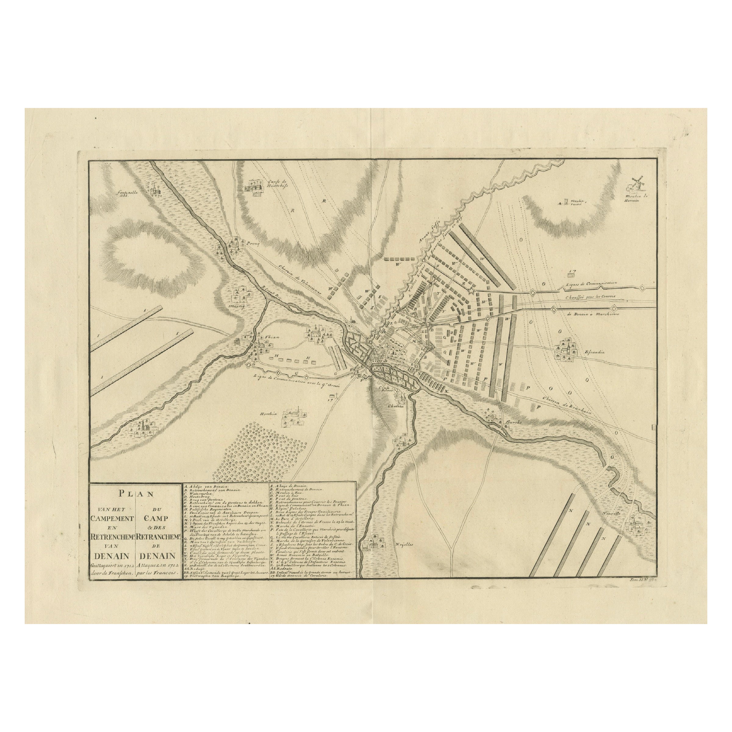
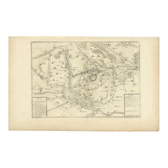
View AllDetailed 1729 Battle Map – Allied Army Camp at Denain France, 1712 Siege
Located in Langweer, NL
Map of Allied Camp at Denain, France, 1712 Attack – Published 1729
This engraved map depicts the army camp of the Allied forces at Denain, attacked by the French on July 24, 1712 du...
Category
Antique Early 18th Century Dutch Maps
Materials
Paper
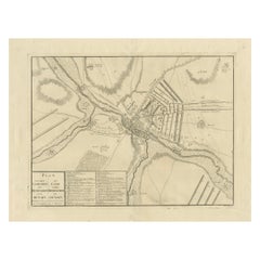
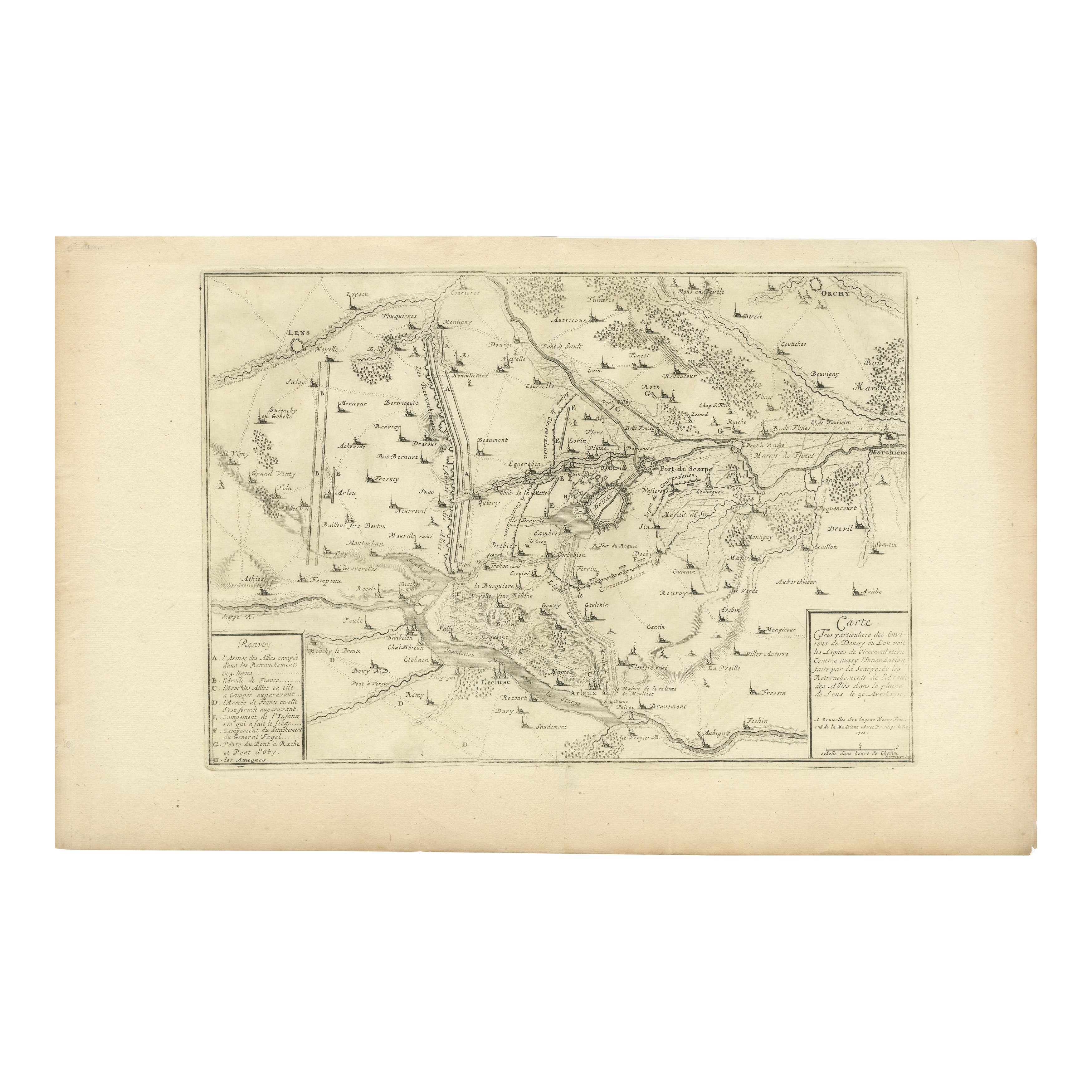
Detailed 1720s Map – Siege of Douay and Lines of Circumvallation, France
Located in Langweer, NL
Detailed 1720s Map – Siege of Douay and Lines of Circumvallation, France
This engraved map shows the detailed fortifications and surrounding region of Douay (Douai) in northern Fran...
Category
Antique Early 18th Century French Maps
Materials
Paper
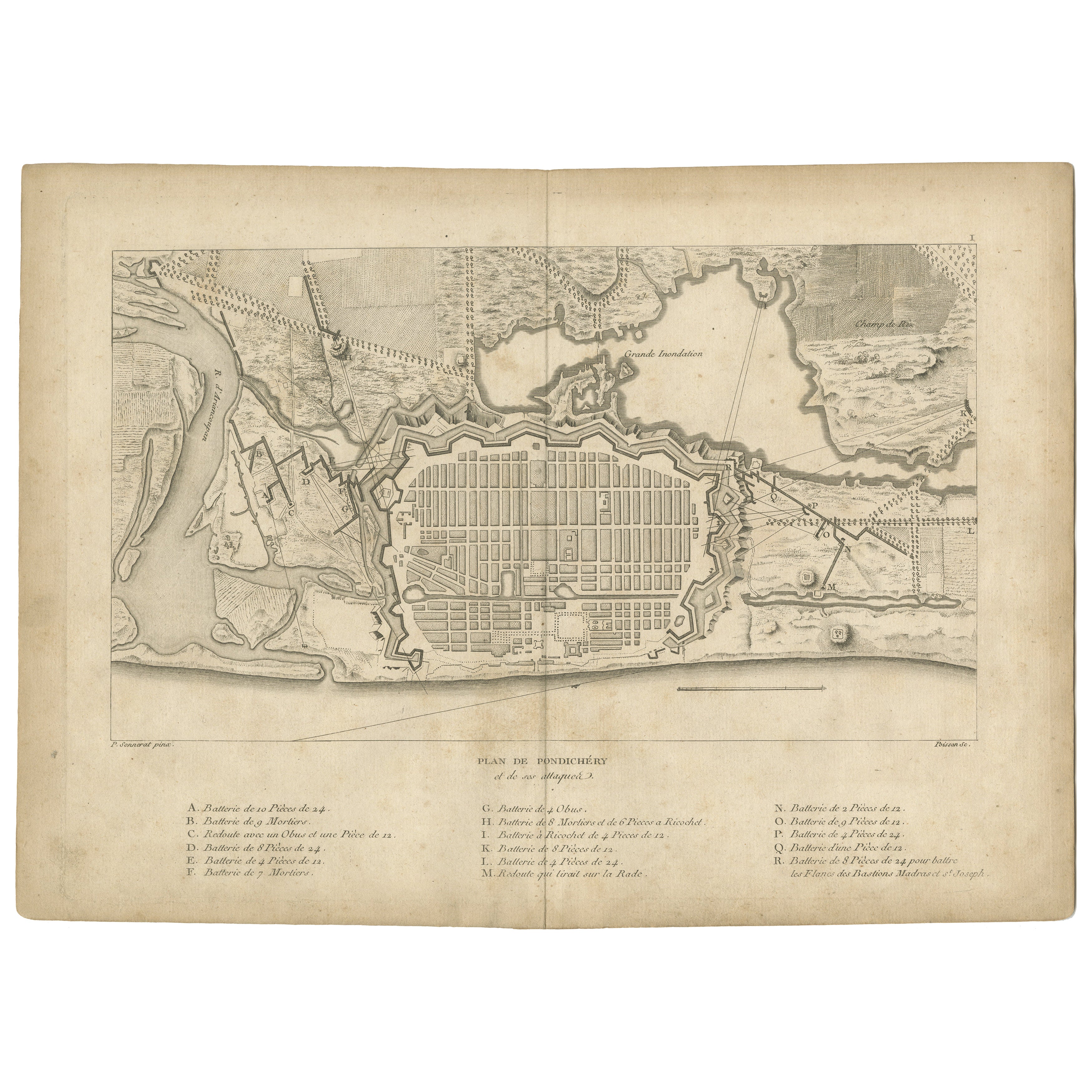
Plan of Pondicherry Fortifications and Attacks, France, c.1750
Located in Langweer, NL
Plan of Pondicherry Fortifications and Attacks, France, c.1750
This finely engraved map depicts the fortified city of Pondicherry, titled "Plan de Pondichéry et de ses attaques." It...
Category
Antique Mid-18th Century French Maps
Materials
Paper
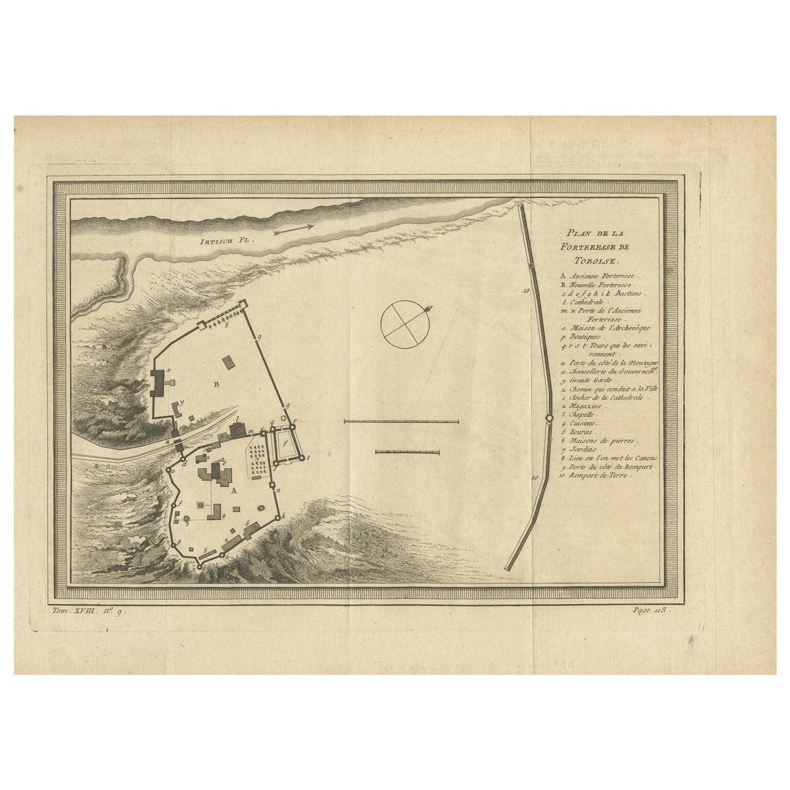
Antique Plan of the Fortress of Tobolsk by Bellin
1768
Located in Langweer, NL
Antique map titled 'Plan de la Forteresse de Tobolsk'. Original plan of the Fortress of Tobolsk, a town in Tyumen Oblast, Russia. Engraved by J.N. Bellin ...
Category
Antique Mid-18th Century Maps
Materials
Paper
$192 Sale Price
20% Off
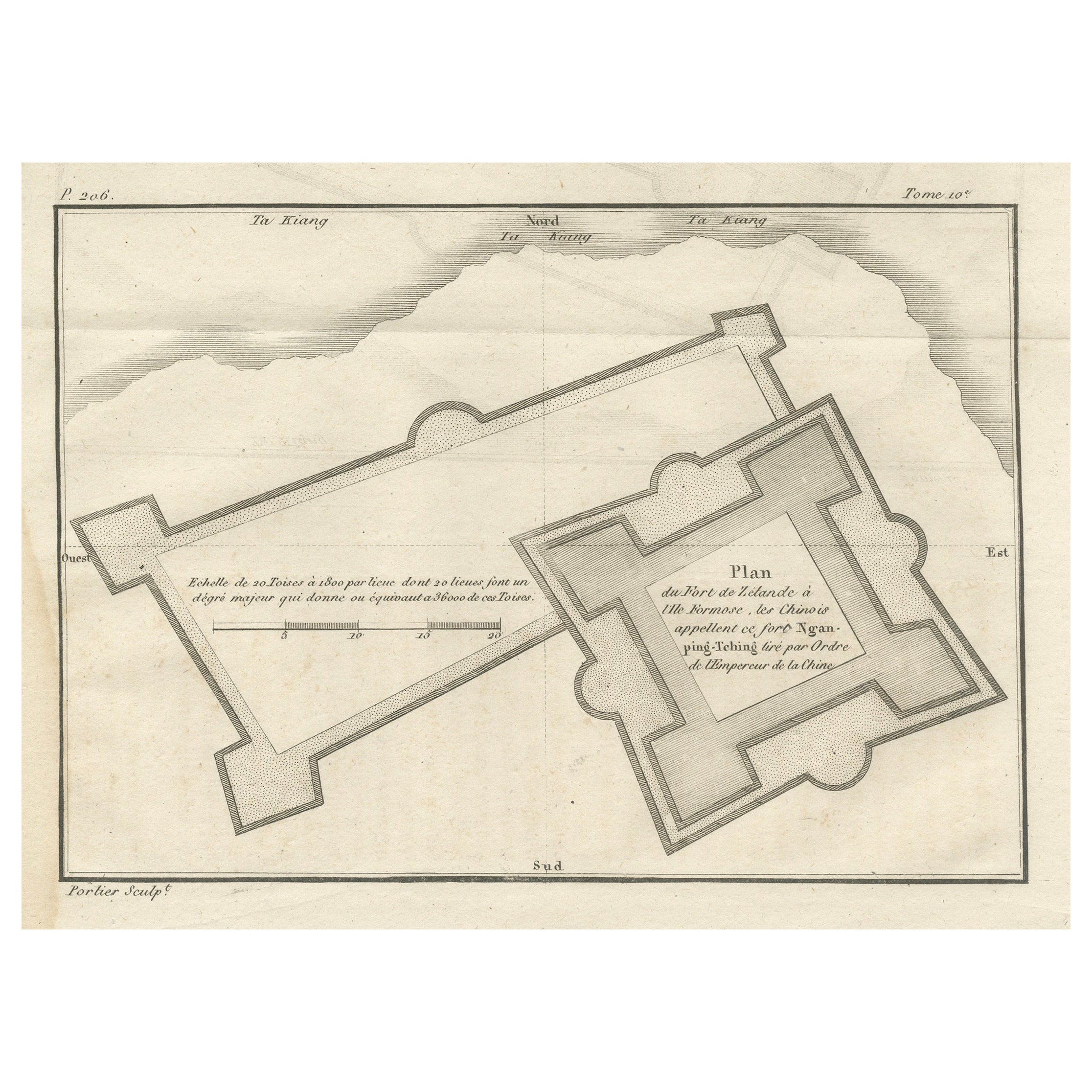
Plan of the Dutch Fort in Formosa – Antique French Jesuit Engraving, ca.1790
Located in Langweer, NL
Plan of the Dutch Fort in Formosa – Antique French Jesuit Engraving by Portier, c.1790
This antique French engraving by Portier, produced around 1790, shows a detailed plan of the D...
Category
Antique Late 18th Century French Maps
Materials
Paper
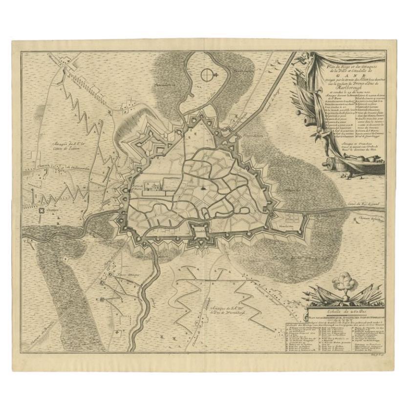
Antique Map of the Siege of Gent by Dumont, 1729
By Dumont
Located in Langweer, NL
Antique map titled 'Plan of the Siege and Attacks of the City and Citadel of Ghent'. Large map depicting the siege of the Belgian city of Gent in 1708 during the war of the Spanish S...
Category
Antique 18th Century Maps
Materials
Paper
You May Also Like
Original Antique Map or City Plan of Geneva, Switzerland. Circa 1835
Located in St Annes, Lancashire
Nice map of Geneva
Drawn and engraved by J.Dower
Published by Orr & Smith. C.1835
Unframed.
Free shipping
Category
Antique 1830s English Maps
Materials
Paper

Battle of Grocka Campaign Map, 1753 - James Oglethorpe, John Lindsay, Henry Köpp
Located in Savannah, GA
A campaign map of the Battle of Grocka, 1753.
Drawn and engraved by Henry Köpp for the journals of John Lindsay, 20th Earl of Crawford and dedicated to James Oglethorpe.
sight:...
Category
Antique 1750s British Prints
Materials
Glass, Wood, Paper
Map of Battle of Smolensk - Etching by Pierre François Tardieu - 1837
Located in Roma, IT
Map of Battle of Smolensk is an Etching realized by Pierre François Tardieu in 1837.
Good conditions.
The artwork is realized in a well-balanced composition. the artwork and belong...
Category
1830s Modern Figurative Prints
Materials
Lithograph
1851 Original map by Maillard - Plan de Paris et ses Fortifications
Located in PARIS, FR
In the world of cartography, maps transcend mere geography; they are historical records and works of art, encapsulating the essence of a place at a specific moment in time. The 1851 ...
Category
1850s Prints and Multiples
Materials
Linen, Paper, Lithograph

18th Century Map Engraving - Newport, a Strong Sea-Port Town in Flanders
Located in Corsham, GB
A map of Nieuwpoort, anglicised to 'Newport', in northern Belgium. There is a panorama in the upper quarter depicting major landmarks. Below is a plan of the town, including its strong defences and ships at the port in the lower register. Inscribed with the title in plate to the lower edge, 'Newport a Strong Sea-Port Town...
Category
18th Century More Prints
Materials
Engraving

$269 Sale Price
20% Off
1748 Map of Richmond Upon Thames by John Roque
Located in Gloucestershire, GB
A 1748 map of Richmond-Upon-Thames by famed surveyor and cartographer, John Roque. Placed in a simple black and gilt frame. The map is in fair condition but there are small sections ...
Category
Antique Mid-18th Century English Maps
Materials
Wood, Paper

More Ways To Browse
Siege Antique
Antique Canon
Antique Canons
French Campaign
China Silk Rug
Chrome Glass Coffee Tables
Antique Italian Chairs
Beni Ourain Rugs
French Iron And Glass Table
Glass Top Wood Base Coffee Tables
T Chair
Antique Silver Basket
Antique Walkers
Ebony Wood Furniture
Opalescent Glass
Pair Of Danish Chairs
Veneer Dining Tables
1970 Italian Armchair