Items Similar to Greenland and California as an Island – Antique Northern Hemisphere Map, ca.1750


Want more images or videos?
Request additional images or videos from the seller
1 of 10
Greenland and California as an Island – Antique Northern Hemisphere Map, ca.1750
$683.46
$854.3220% Off
£510.23
£637.7920% Off
€576
€72020% Off
CA$949.53
CA$1,186.9120% Off
A$1,021.35
A$1,276.6920% Off
CHF 545.84
CHF 682.3020% Off
MX$12,038.84
MX$15,048.5520% Off
NOK 6,881.77
NOK 8,602.2220% Off
SEK 6,291.25
SEK 7,864.0620% Off
DKK 4,389.77
DKK 5,487.2120% Off
About the Item
Greenland and California as an Island – Antique Northern Hemisphere Map, ca.1750
Antique map titled 'Nieuwe Kaart van de Noord Pool na de alderlaatste ontdekking int licht gebracht tot Amsterdam door Isaak Tirion'. Beautiful map of the Northern Hemisphere and North Pole, which shows the NE Passage, but no definite NW Passage. California is shown as an Island, along with the River systems of North America. Nice detail in the Polar regions, especially New Denmark and Greenland and in Asia and Europe. Engraved by J. Keyser. Published by I. Tirion, circa 1750.
- Creator:Isaak Tirion (Artist)
- Dimensions:Height: 13.98 in (35.5 cm)Width: 18.9 in (48 cm)Depth: 0.02 in (0.5 mm)
- Materials and Techniques:
- Place of Origin:
- Period:
- Date of Manufacture:circa 1750
- Condition:Repaired: repair on bottom (closed tear). Original/contemporary hand coloring. General age-related toning. Original folding line, with repair on bottom (closed tear). Blank verso. Please study images carefully.
- Seller Location:Langweer, NL
- Reference Number:Seller: BG-132531stDibs: LU3054331005082
About the Seller
5.0
Recognized Seller
These prestigious sellers are industry leaders and represent the highest echelon for item quality and design.
Platinum Seller
Premium sellers with a 4.7+ rating and 24-hour response times
Established in 2009
1stDibs seller since 2017
2,836 sales on 1stDibs
Typical response time: 1 hour
- ShippingRetrieving quote...Shipping from: Langweer, Netherlands
- Return Policy
More From This Seller
View AllGreenland
the North Pole – Antique Northern Hemisphere Map by Tirion, c.1754
Located in Langweer, NL
Greenland & the North Pole – Antique Northern Hemisphere Map by Tirion, c.1754
ntique map titled 'Nieuwe Kaart van de Noord Pool na de alderlaatste ondekking int licht gebracht'. Ma...
Category
Antique Mid-18th Century Dutch Maps
Materials
Paper

$666 Sale Price
25% Off
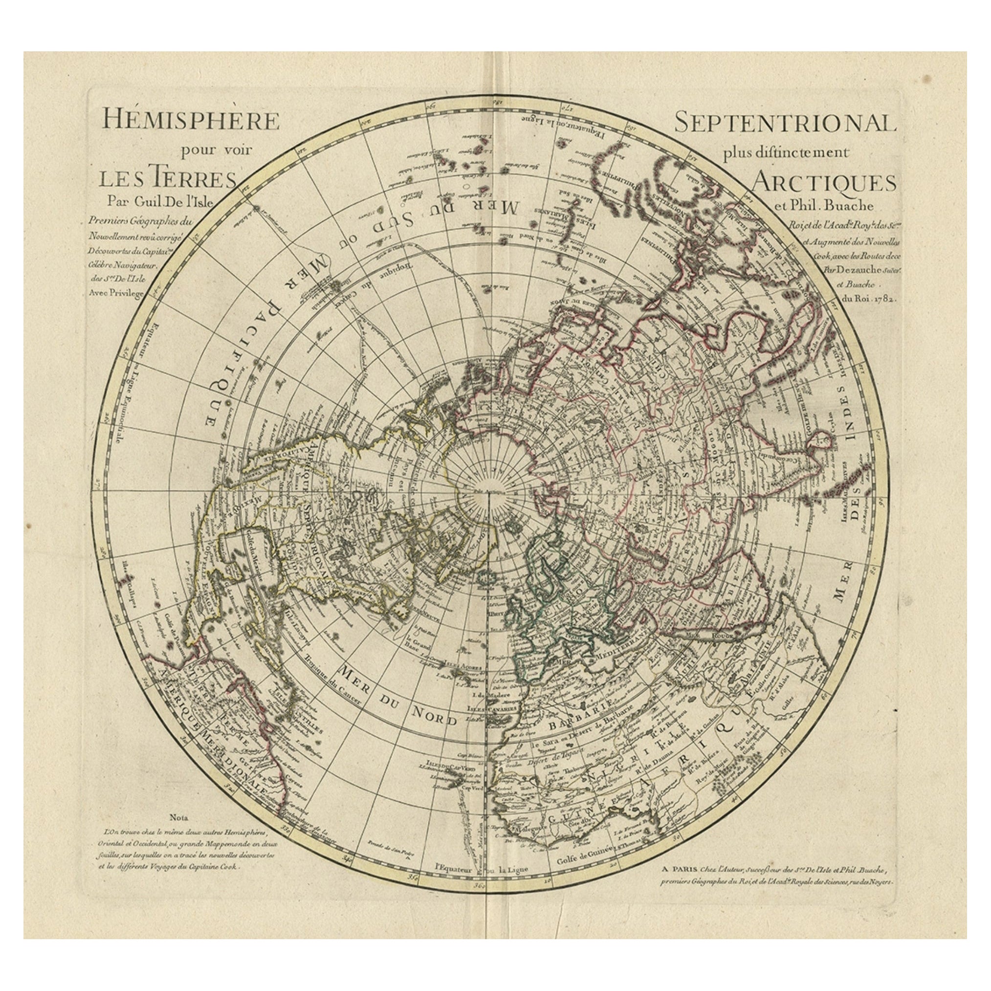
Antique Map of the Northern Hemisphere, 1782
Located in Langweer, NL
Antique map titled 'Hémisphère Septentrional pour voir plus distinctement les Terres Arctiques (..)'.
Map of the Northern Hemisphere, originall...
Category
Antique 1780s Maps
Materials
Paper
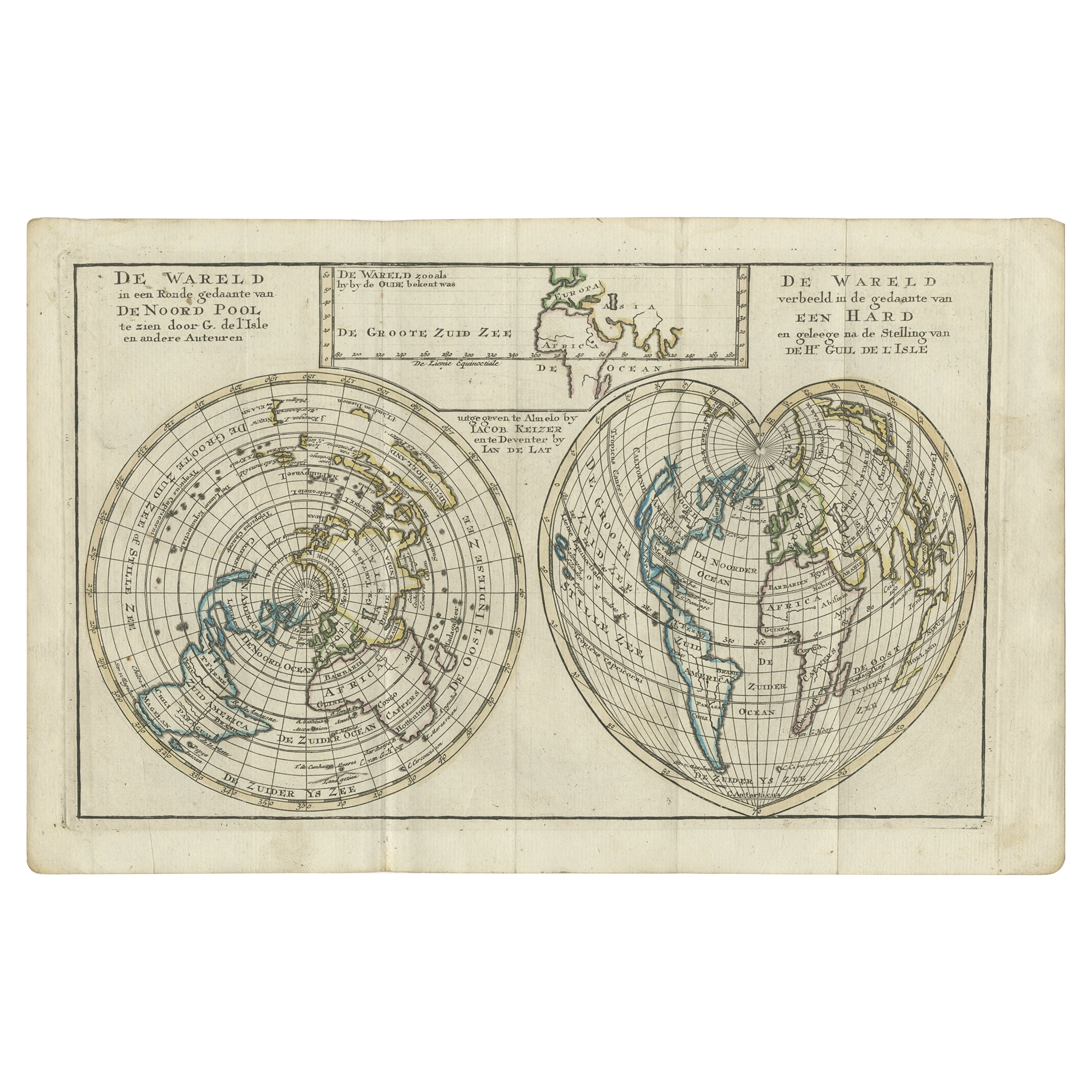
Antique Map of the World with California as an Island, 1788
Located in Langweer, NL
Description: Antique map titled 'De wareld in een ronde gedaante van de Noord Pool te zien - De Wareld verbeeld in de gedaante van een hard'. This interesting composition contains three world maps on the sheet. At left is a northern projection showing all the landmasses. At right is a cordiform projection (heart-shaped). At top is a map of the world as known to the ancients. Both the polar and cordiform projections show California as an island...
Category
Antique 1780s Maps
Materials
Paper

Antique Map of the Eastern Hemisphere by Valk
Chenk
1708
Located in Langweer, NL
Antique map titled 'Hemispherium Orbis Antiqui, Cumzonis Circulis, Et Sity populorum Diverso'. Decorative example of Andreas Cellarius's map of the Eastern Hemisphere, illustrating with climatic zones ranging from Frigida Borealis to Torrida, with planetary details superimposed. The elaborate border includes fine scrollwork, numerous putti, and additional diagrams showing armillary spheres and climatic zones. Andreas Cellarius was born in 1596 in Neuhausen and educated in Heidelberg. He emigrated to Holland in the early 17th century and 1637 moved to Hoorn, where he became the rector of the Latin School. Cellarius' best known work is his Harmonia Macrocosmica, first issued in 1660 by Jan Jansson, as a supplement to Jansson's Atlas Novus. The work consists of a series of Celestial Charts...
Category
Antique Early 18th Century Dutch Maps
Materials
Paper

$4,004 Sale Price
25% Off
Attractive Antique Map of the World as Planisphere, Shows Cook
s Voyages, 1799
Located in Langweer, NL
Antique map titled 'Chart of the World, according to Mercators Projection'. This world map shows the various discoveries of Captain James Cook during his 3 voyages between 1768 and 1780, and the English and French Explorers who followed immediately thereafter, including Vancouver and La Perouse. This edition of the map is significantly revised from the editions issued immediately after the official report of Cook's Voyages were integrated into the map, showing better detail in New Zealand, Australia, the Northwest Coast of America and North East coast of Asia, along with Greenland. A new large lake also appears for the first time in the Western part of North America, shortly before the commencement of the Lewis...
Category
Antique Late 18th Century British Maps
Materials
Paper

$1,334 Sale Price
25% Off
Free Shipping
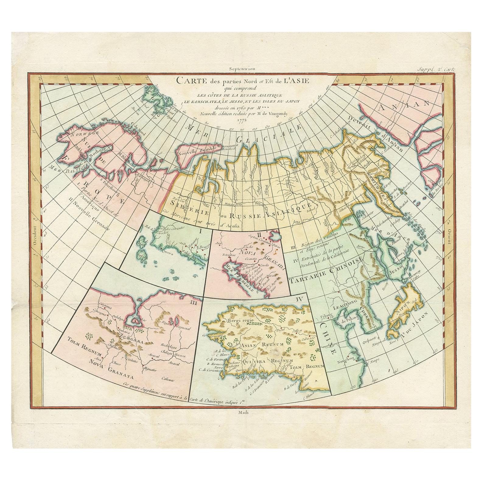
Antique Map of North Europe and East Asia by Vaugondy, circa 1750
Located in Langweer, NL
Antique map titled 'Carte des parties nord et est de L'Asie'. Map of the Northern parts and East Asia. Five maps on one sheet, showing California, Alaska and Syberia, Korea and Japan...
Category
Antique Mid-18th Century French Maps
Materials
Paper

You May Also Like
Original Antique Map of The World by Thomas Clerk, 1817
Located in St Annes, Lancashire
Great map of The Eastern and Western Hemispheres
On 2 sheets
Copper-plate engraving
Drawn and engraved by Thomas Clerk, Edinburgh.
Published by Mackenzie And Dent, 1817
...
Category
Antique 1810s English Maps
Materials
Paper

Antique Map of Eastern Hemisphere from the collection of Thierry Despont
Located in New York, NY
Designed by Enrico Bonetti (E. Bonatti) and published by Francesco Vallardi Editore. Based on an earlier map by Evangelista Azzi (Ev. Azzi). Labeled as such at bottom edge of map.
T...
Category
Antique Late 19th Century Italian Maps
Materials
Canvas, Wood

Original Antique Map of The Western Hemisphere by Dower, circa 1835
Located in St Annes, Lancashire
Nice map of the Western Hemisphere
Drawn and engraved by J.Dower
Published by Orr & Smith. C.1835
Unframed.
Free shipping
Category
Antique 1830s English Maps
Materials
Paper

Large Original Vintage Map of North America, circa 1920
Located in St Annes, Lancashire
Great map of North America
Original color. Good condition
Published by Alexander Gross
Unframed.
Category
Vintage 1920s English Edwardian Maps
Materials
Paper

Large Original Antique Map of The World, Fullarton, C.1870
Located in St Annes, Lancashire
Great map of the World. Showing both hemispheres
From the celebrated Royal Illustrated Atlas
Lithograph. Original color.
Published by Fullarton, Edinburgh, C.1870
Unframed.
Rep...
Category
Antique 1870s Scottish Maps
Materials
Paper

Original Antique Map of The World by Dower, circa 1835
Located in St Annes, Lancashire
Nice map of the World
Drawn and engraved by J.Dower
Published by Orr & Smith. C.1835
Unframed.
Free shipping
Category
Antique 1830s English Maps
Materials
Paper

More Ways To Browse
Antique Furniture California
Antique Map Of Cornwall
Antique Maps Dublin
Antique Maps Of Malta
Antique Saudi Arabia
Armenia Map
Cambodia Antique Map
Coronelli Globe
Denoyer Geppert Anatomy
E Fletcher
Framed Africa Maps
Gabon Antique Map
Hudson River Map
Lancashire Map
Map Of Barbados
Nova Hollandia
Used Furniture Cleveland Ohio
Vintage Bartholomew Maps