Want more images or videos?
Request additional images or videos from the seller
1 of 9
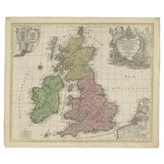
Beneath the Surface: James Wyld
s 1844 Geological Map of the British Isles
Price:$774.53
$861.65List Price
About the Item
- Dimensions:Height: 27.17 in (69 cm)Width: 16.93 in (43 cm)Depth: 0 in (0.02 mm)
- Materials and Techniques:
- Period:
- Date of Manufacture:1844
- Condition:Preserved in good to excellent condition, this map remains vibrant and clear, with minimal signs of age, ensuring its value and appeal as a collector s item and a decorative piece. Study the images carefully.
- Seller Location:Langweer, NL
- Reference Number:Seller: BG-138241stDibs: LU3054341192872
About the Seller
5.0
Recognized Seller
These prestigious sellers are industry leaders and represent the highest echelon for item quality and design.
Platinum Seller
Premium sellers with a 4.7+ rating and 24-hour response times
Established in 2009
1stDibs seller since 2017
2,793 sales on 1stDibs
Authenticity Guarantee
In the unlikely event there’s an issue with an item’s authenticity, contact us within 1 year for a full refund. DetailsMoney-Back Guarantee
If your item is not as described, is damaged in transit, or does not arrive, contact us within 7 days for a full refund. Details24-Hour Cancellation
You have a 24-hour grace period in which to reconsider your purchase, with no questions asked.Vetted Professional Sellers
Our world-class sellers must adhere to strict standards for service and quality, maintaining the integrity of our listings.Price-Match Guarantee
If you find that a seller listed the same item for a lower price elsewhere, we’ll match it.Trusted Global Delivery
Our best-in-class carrier network provides specialized shipping options worldwide, including custom delivery.You May Also Like
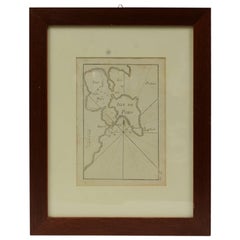
Northwest Coast and Isle of Man Map
Located in Cheshire, GB
Greenville Collins Northwest Coast and Isle of Man. hand coloured chart, encased in an ebonised frame.
Dimensions
Height 26.5 Inches
Width 30 Inches
Depth 1 Inches
Category
Early 20th Century British Maps
Materials
Paper

Antique Nautical Portolano of Isle De Poro by Antoine Roux, France, 1844
By Antoine Roux
Located in Milan, IT
Antique portolano, nautical map of Isle De Poro engraved on a copper plate by Antoine Roux, Marseille France 1844, from his work Recueil des principaux plans des ports et de Rades de...
Category
Antique 1840s French Nautical Objects
Materials
Paper
$538
H 14.97 in W 12.21 in D 0.79 in
1999 Sporting Wildfowl of the British Isles: Studies in Words and Pictures
Located in Bath, GB
A sumptuous study of the wildfowl of the British Isles, one of only twelve review copies, sent to sporting and countryside author John Humphreys. Signed...
Category
1990s European Books
Materials
Paper
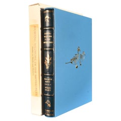
$4,768
H 14 in W 2 in D 13 in
Antique Lithography Map, Isle of Thanet, Kent, English, Cartography, Victorian
Located in Hele, Devon, GB
This is an antique lithography map of The Isle of Thanet in Kent. An English, framed atlas engraving of cartographic interest, dating to the mid 19th century and later.
Superb litho...
Category
Antique Mid-19th Century British Victorian Maps
Materials
Wood

$696
H 14.57 in W 16.15 in D 0.6 in
1844 Map "Russia in Eurpoe, Part II to Part VIII", 7 Maps Ric.r023
Located in Norton, MA
1844 Map "Russia in Eurpoe, Part II to Part VIII"
7 Maps
Ric.r023
Fine, original, steel-engraved Map of Russia in Europe Part II t oPart VIII, by the Society for the Diffusion of Useful Knowledge. Detailed map of the regions to the northeast of Moscow. Including Arkhangel, Vologda, Viatka, Perm, Olonetz, Iaroslavl. The SDUK began its map publishing project under the leadership of Captain Francis Beaufort R.N. in 1829, and published the maps in parts, haltingly, over the next 15 years, completing the series in 1844, finally permitting the publication of a whole atlas. Many of the maps were actually drawn by Beaufort, who at the time was the Hydrographer to the Royal Navy, and all were closely supervised by him. J. & C. Walker worked closely with Beaufort in engraving the maps. Finely engraved, carefully researched, the maps set...
Category
Antique 19th Century Unknown Maps
Materials
Paper

$475
H 14.18 in W 17.33 in D 0.4 in
Map Hanging Wall County of Devon C&J Greenwood 1827 Exeter Cathedral Lundy Isle
Located in BUNGAY, SUFFOLK
C & J GREENWOOD MAP OF THE COUNTY OF DEVON, FROM AN ORIGINAL SURVEY, PUBLISHED 1827, WITH ENGRAVING OF EXETER CATHEDRAL AND MAP OF LUNDY INSET, 6ft 2 ...
Category
Antique 1820s English Early Victorian Maps
Materials
Paper
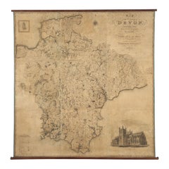
$13,625
H 76.23 in W 74.26 in D 0.4 in
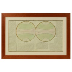
1850 Old French Map Depicting the Entire Earth
s Surface Divided into Two Parts
Located in Milan, IT
Map depicting the entire earth's surface divided into two parts corresponding to the two hemispheres and showing the Arctic to Antarctic polar circle, the tropics of Cancer and Capri...
Category
Antique Mid-19th Century French Maps
Materials
Glass, Wood, Paper
$1,555
H 18.51 in W 27.76 in D 0.79 in
Old Map Depicting the Entire Earth
s Surface Divided into Six Parts France 1850
Located in Milan, IT
Map depicting the entire earth's surface divided into six parts which depicts the position of peoples on Earth based on the assumption that it is impossible for each people to have t...
Category
Antique Mid-19th Century French Maps
Materials
Glass, Wood, Paper

$1,555
H 18.51 in W 27.76 in D 0.79 in
1850 Old French Map Depicting the Entire Earth
s Surface Divided into Two Parts
Located in Milan, IT
Geographical map depicting the entire earth's surface divided into two parts that correspond to the two hemispheres where the emerged lands are depicted which have been classified wi...
Category
Antique Mid-19th Century French Maps
Materials
Glass, Wood, Paper

$1,555
H 18.51 in W 25.99 in D 0.79 in
1850 Old French Map Depicting the Entire Earth
s Surface Divided into Two Parts
Located in Milan, IT
Geographical map depicting the entire earth’s surface divided into two parts that correspond to the two hemispheres or globes, the map deals with the latitudes and longitudes, the me...
Category
Antique Mid-19th Century French Maps
Materials
Glass, Wood, Paper

$1,555
H 18.19 in W 25.87 in D 0.79 in
More From This Seller
View AllAntique Map of the British Isles by Balbi
1847
Located in Langweer, NL
Antique map titled 'Iles Britanniques'. Original antique map of the British Isles. This map originates from 'Abrégé de Géographie (..)' by Adrien Balbi. ...
Category
Antique Mid-19th Century Maps
Materials
Paper

$143 Sale Price
20% Off
Antique Map of the British Isles by Lotter, 1764
Located in Langweer, NL
Antique map titled 'Le Grand Bretagne ou les Royaumes d'Angleterre et d'Ecosse'. Old engraved map of the British Isles (main islands United Kingdom & Ire...
Category
Antique 18th Century Maps
Materials
Paper
$320 Sale Price
20% Off
Antique Map of the British Isles by Delamarche, 1806
Located in Langweer, NL
Antique map titled 'Les Isles Britanniques.' Decorative map of the British Isles by Robert de Vaugondy, revised and published by Delamarche. Source unkno...
Category
Antique 19th Century Maps
Materials
Paper

$143 Sale Price
20% Off
Antique Map of the British Isles by Johnston
1909
Located in Langweer, NL
Antique map titled 'The British Isles'. Original antique map of the British Isles. With inset maps of the Shetland Islands, Chanel Islands, and London. T...
Category
Early 20th Century Maps
Materials
Paper
$239 Sale Price
20% Off
Antique Map of the British Isles by H. Chatelain, 1719
By Henri-Abraham Chatelain
Located in Langweer, NL
Beautiful hand colored large format map of the British Isles, with large insets of the Eastern and Western Hemispheres and the coats of arms for Engl...
Category
Antique Early 18th Century Maps
Materials
Paper

Map of the British Isles with Historical Kings, 1719
Located in Langweer, NL
This antique map, titled "Les Royaumes d'Angleterre d'Escosse et d'Irlande," offers a detailed view of the British Isles, including England, Wales, Scotland, and Ireland. Additionall...
Category
Antique Early 18th Century Maps
Materials
Paper
$421 Sale Price
20% Off
Still Thinking About These?
All Recently ViewedMore Ways To Browse
Victorian Bustle
Antique Victorian Bustle
Goblets
Mid Century Modern Yellow Chair
Paulin Pierre
Used Pianos Pianos
18th Century Engravings
Antique Carved Wood Chair
Black Scandinavian Modern Dining Chairs
Dutch Mid Century Modern Table
Gold Modern Coffee Table
Iconic Modern Furniture
Japanese Metal
Midcentury Modern Gray Glass Vase
Round Glass Coffee Tables
Vintage Cave
18th Century Wood Side Tables
Antique Hand Carved Dining Room Sets