Items Similar to Biblical Journeys: Apostle Paul
s Voyages and the Israelites
Exodus, 1856


Want more images or videos?
Request additional images or videos from the seller
1 of 8
Biblical Journeys: Apostle Paul
s Voyages and the Israelites
Exodus, 1856
$395.99per set
£293.45per set
€330per set
CA$541.20per set
A$589.14per set
CHF 312.71per set
MX$7,088.59per set
NOK 3,962.51per set
SEK 3,630.78per set
DKK 2,513.71per set
About the Item
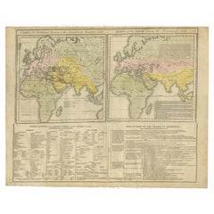
Two maps in matting board. From the Pictorial Bible Atlas, published in 1856.
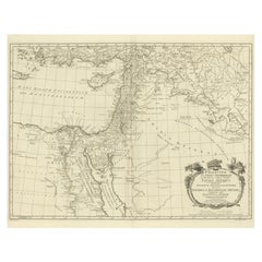
Title for Map 1: Voyages and Travels of Apostle Paul – Illustrated Antique Map
This hand-colored antique map depicts the voyages of Apostle Paul, tracing his journeys through the Mediterranean and highlighting key cities such as Rome, Corinth, and Ephesus. Surrounding the map are illustrations of significant events from Paul’s life, including his preaching, imprisonment, and missionary work. Published in the mid-19th century, the map blends geographical detail with biblical history to vividly recount Paul’s travels.
Title for Map 2: The Journeys of the Israelites from Egypt to Canaan – Illustrated Antique Map
This hand-colored map illustrates the route of the Israelites’ exodus from Egypt to Canaan, the Promised Land. Biblical scenes frame the map, depicting events such as Moses parting the Red Sea, the Golden Calf, and the Ark of the Covenant. The map outlines key locations and stories from the Book of Exodus, reflecting the mid-19th century fascination with religious themes and historical cartography.
Presentation and Condition:
Both maps are in good condition, featuring vibrant hand-coloring and sharp details with a few minor spots or creases (folding line) due to age and handling. They are elegantly mounted in cream matting boards, enhancing their presentation and ensuring protection for display or archival storage. These maps are remarkable for their combination of religious storytelling and antique cartographic artistry.
- Dimensions:Height: 12.01 in (30.5 cm)Width: 13 in (33 cm)Depth: 0.12 in (3 mm)
- Sold As:Set of 2
- Materials and Techniques:Paper,Engraved
- Period:
- Date of Manufacture:1856
- Condition:Both maps are in good condition, featuring vibrant hand-coloring and sharp details with a few minor spots or creases (folding line) due to age and handling. They are elegantly mounted in cream matting boards, enhancing their presentation.
- Seller Location:Langweer, NL
- Reference Number:Seller: BG-14035-1 and -21stDibs: LU3054342826892
About the Seller
5.0
Recognized Seller
These prestigious sellers are industry leaders and represent the highest echelon for item quality and design.
Platinum Seller
Premium sellers with a 4.7+ rating and 24-hour response times
Established in 2009
1stDibs seller since 2017
2,819 sales on 1stDibs
Typical response time: 1 hour
- ShippingRetrieving quote...Shipping from: Langweer, Netherlands
- Return Policy
More From This Seller
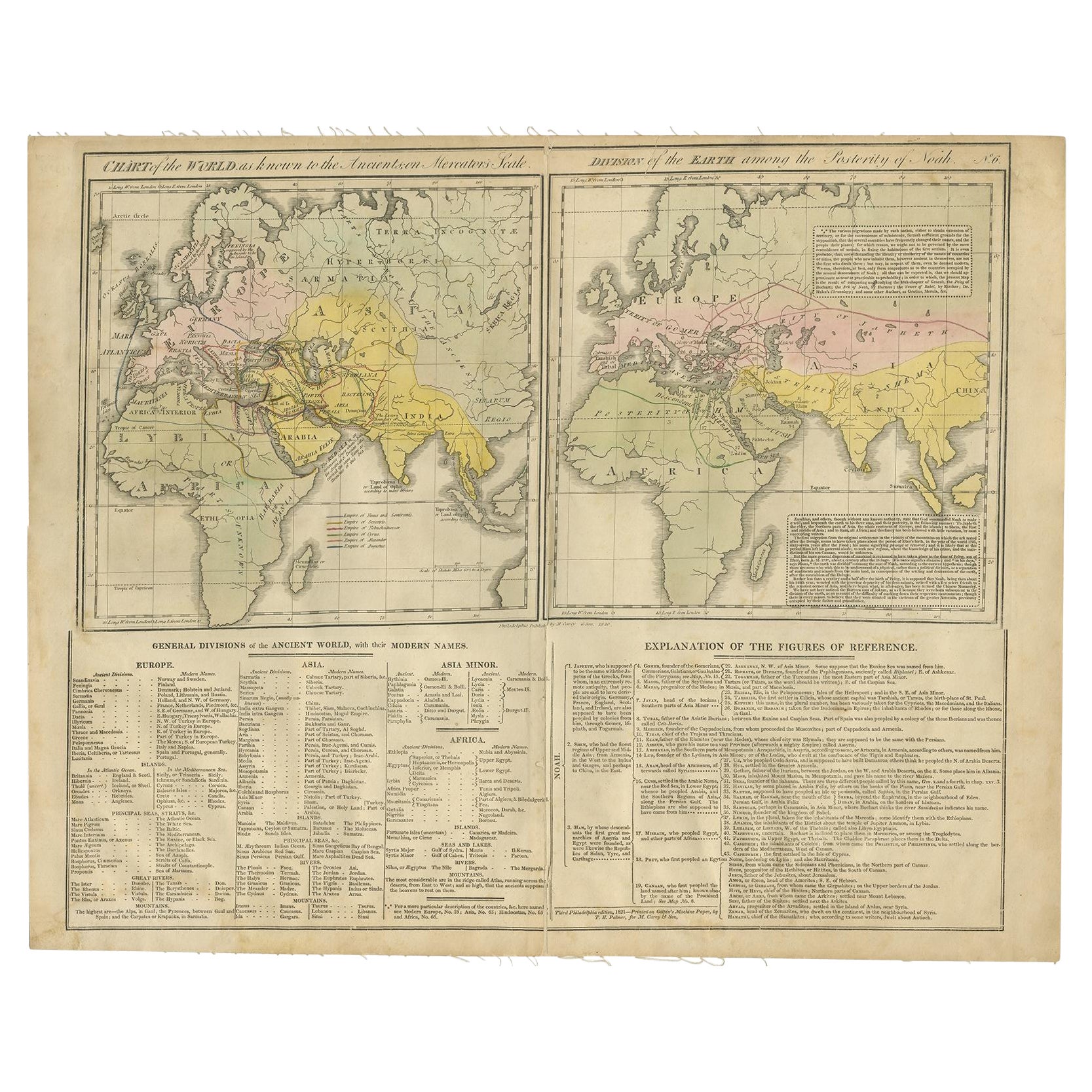
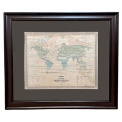
View AllMaps of the Ancient World and the Posterity of Noah, 1820
Located in Langweer, NL
Two maps on one sheet. Hhand colored engraved lithograph, depicting the world as known to the Ancients on Mercator's projection and the Posterity of Noah. The first showns the Empire...
Category
Antique 19th Century Prints
Materials
Paper
Empire of the Parthians: Historical Cartographic Masterpiece by d
Anville, 1819
Located in Langweer, NL
Description:
Ancient map of the Parthian Empire (19th century), original engraving extracted from the atlas of the history of the emperors from 1819, based on the history of the Rom...
Category
Antique 1810s Maps
Materials
Paper
$95 Sale Price
20% Off
Antique Map of the World in two sheets, 1852
Located in Langweer, NL
Antique map titled 'The World on Mercator's Projection'. Two individual sheets of the world. This map originates from 'Lowry's table Atlas constructed and engraved from the most rece...
Category
Antique Mid-19th Century Maps
Materials
Paper

$239 Sale Price / set
20% Off
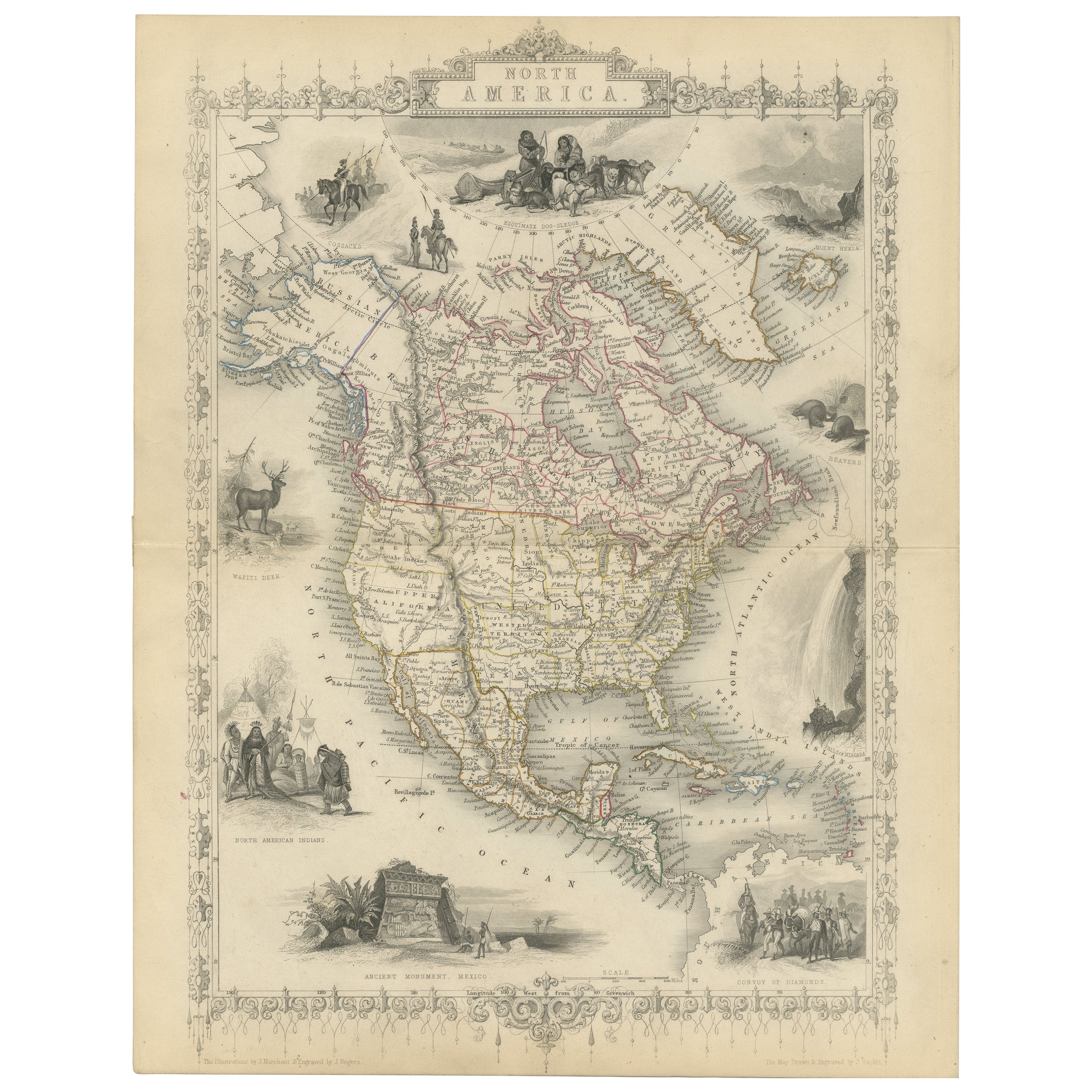
Victorian Visions of the New World: A Detailed Tallis Map of North America, 1851
Located in Langweer, NL
The map presented here is an intricate example from the series of maps produced by John Tallis & Company. Tallis maps are known for their detailed and elaborate style, often includin...
Category
Antique 1850s Maps
Materials
Paper
$345 Sale Price
20% Off
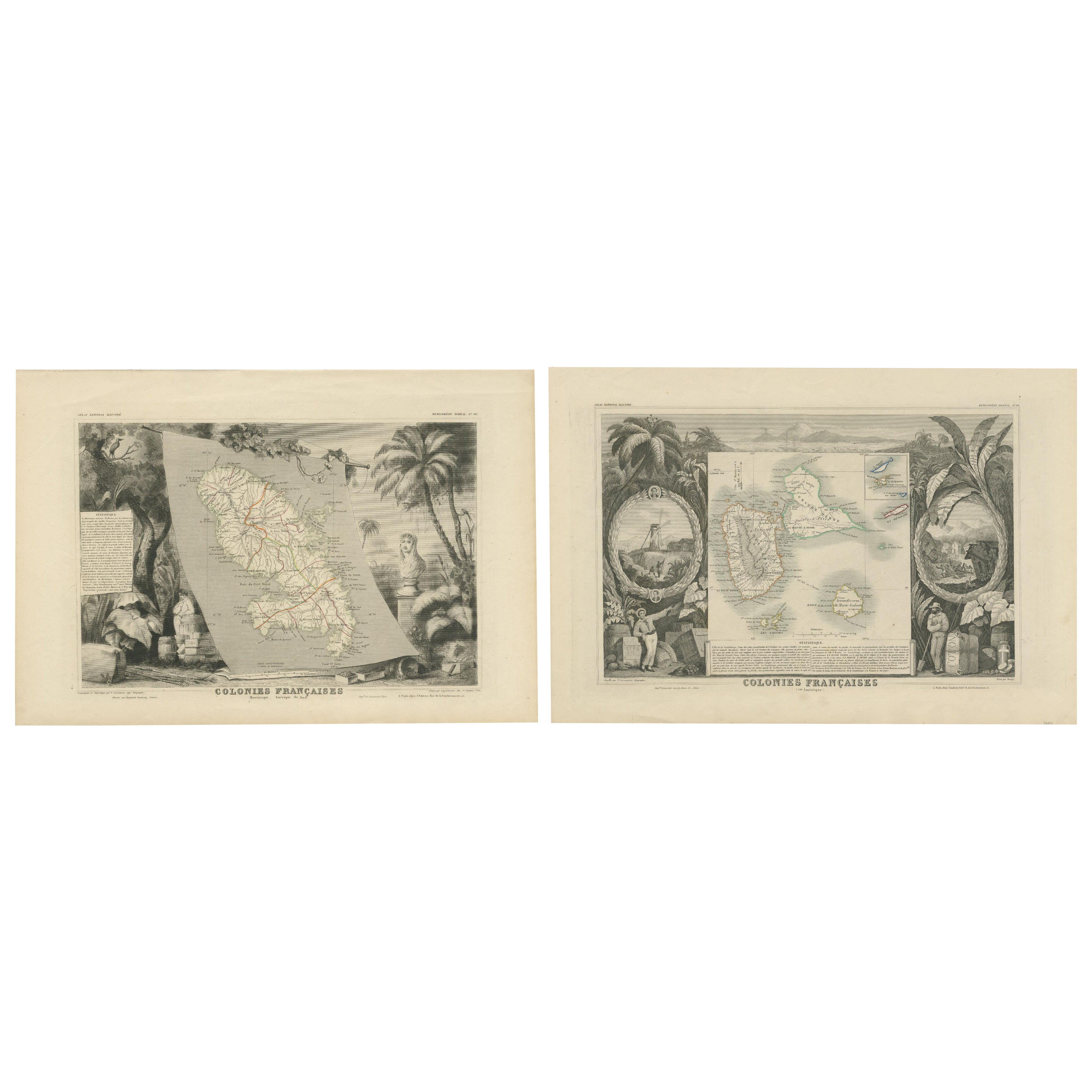
French Colonies in the Caribbean: Maps of Martinique and Guadeloupe (1852)
Located in Langweer, NL
This pair of maps, published in 1852, provides a detailed representation of the French Caribbean colonies, specifically Martinique and Guadeloupe. They were part of the *Atlas Univer...
Category
Antique 1850s Maps
Materials
Paper
$316 Sale Price / set
20% Off
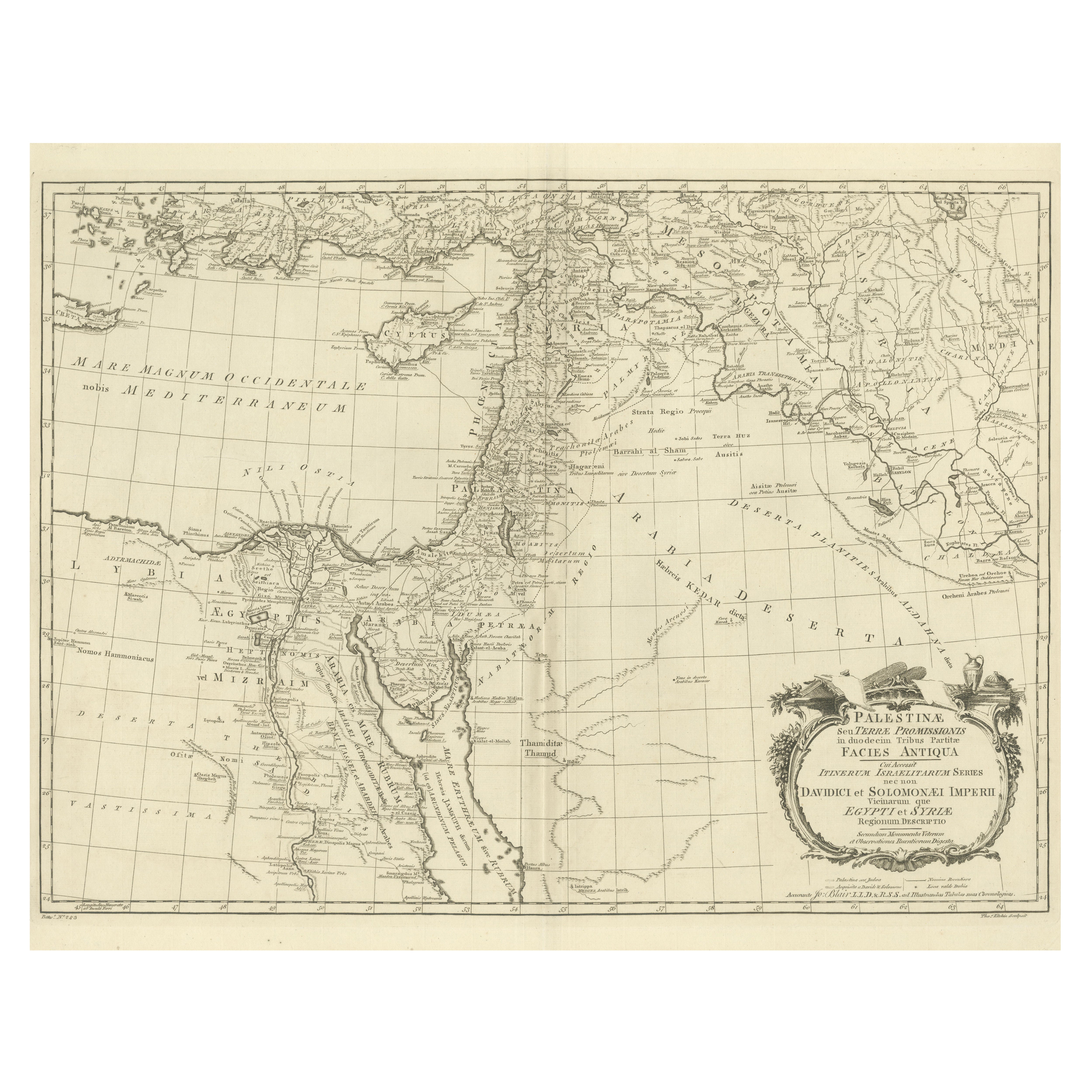
1773 John Blair Map of the Ancient Holy Land: Tribes, Journeys, and Empires
Located in Langweer, NL
Title: 1773 John Blair Map of the Ancient Holy Land: Tribes, Journeys, and Empires
This exceptional map by John Blair, published in London in 1773, offers a richly detailed view o...
Category
Antique 1770s English Maps
Materials
Paper
You May Also Like
Original Antique Map of The World by Thomas Clerk, 1817
Located in St Annes, Lancashire
Great map of The Eastern and Western Hemispheres
On 2 sheets
Copper-plate engraving
Drawn and engraved by Thomas Clerk, Edinburgh.
Published by Mackenzie And Dent, 1817
...
Category
Antique 1810s English Maps
Materials
Paper

1851 Map of "Independent Tartary", Ric. R018
Located in Norton, MA
1851 Map of
Independent Tartary
"Russia"
Ric.r018
A highly decorative 1851 map of Independent Tartary by John Tallis and John Rapkin. Covers the regions between the Caspian Sea and Lake Bakquash and between Russia and Afghanistan. These include the ancient Silk Route kingdoms of Khiva, Tartaria, Kokand, and Bokhara. Today this region roughly includes Kazakhstan, Uzbekistan, Turkmenistan, Kyrgyzstan, and Tajikistan. This wonderful map offers a wealth of detail for anyone with an interest in the Central Asian portion of the ancient Silk Road. Identifies various caravan routes, deserts, wells, and stopping points, including the cities of Bokhara and Samarkand. Three vignettes by W. Bragg decorate the map, these including an image of Tartars on a Journey, a horseback Bride Chase, and a tartar camp site. Surrounded by a vine motif border. Engraved by J. Rapkin for John Tallis's 1851 Illustrated Atlas .
Tartary Antique Map...
Category
Antique 19th Century Unknown Maps
Materials
Paper

1870 "Johnson
s World" by Prof. A. Guyot, Published by A. J. Johnson
Located in Colorado Springs, CO
Presented is an original "Johnson's World, Showing the Distribution of the Characteristic Forest Trees, Principal Useful Plants and Minerals" by Prof. A. Guyot. This map was issued a...
Category
Antique 1870s American Victorian Maps
Materials
Paper
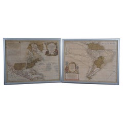
Pair Antique Italian Maps of the North American Eastern Seaboard
Located in New York, NY
Pair antique Italian maps of the North American Eastern Seaboard. Late 18th early 19th century original Italian documentation of the East Coast of the United States from Passamaquadd...
Category
Antique Late 18th Century Italian Maps
Materials
Wood, Paper

18th Century Antique Conrad Lotter Septentrionalis Meridionalis American Maps
Located in Dayton, OH
Pair of rare hand colored maps from the 1770's, depicting "America Septentrionalis" (North America), engraved by Georg Friedrich Lotter and America Meridionalis (South America), engr...
Category
Antique 18th Century Maps
Materials
Paper
$2,100 Sale Price
30% Off
1850 Old French Map Depicting the Entire Earth
s Surface Divided into Two Parts
Located in Milan, IT
Geographical map depicting the entire earth's surface divided into two parts that correspond to the two hemispheres where the emerged lands are depicted which have been classified wi...
Category
Antique Mid-19th Century French Maps
Materials
Glass, Wood, Paper

More Ways To Browse
Antique Ark
Apostle Paul
Map Storage
Antique Map Storage
Blue Green Wool And Silk Rug
Brown Sheepskin Chair
Vintage Brass Bar Carts
Antique Botanical Prints
Green Persian Rug
50 X 50 Coffee Table
Milo Baughman 1970
Spanish Baroque Furniture
Stone China
Couch Console
Vintage Burn
Chinese Stone
Sterling Silver Flatware Service For 12
Antique Dining Tables With Leaves