Want more images or videos?
Request additional images or videos from the seller
1 of 5
The Biblical Kingdom of Israel under the Kings Saul, David and Solomon, Ca.1758
Price:$436.65
About the Item
- Dimensions:Height: 15.16 in (38.5 cm)Width: 19.3 in (49 cm)Depth: 0 in (0.02 mm)
- Materials and Techniques:
- Period:1750-1759
- Date of Manufacture:circa 1758
- Condition:Wear consistent with age and use. Condition: Good, given age. Slight discolouration near middle fold. Some minor crinkles. A few small spots. Original middle fold as issued. General age-related toning and/or occasional minor defects from handling. Please study image carefully.
- Seller Location:Langweer, NL
- Reference Number:Seller: PCT-61940 1stDibs: LU3054327047262
About the Seller
5.0
Recognized Seller
These prestigious sellers are industry leaders and represent the highest echelon for item quality and design.
Platinum Seller
Premium sellers with a 4.7+ rating and 24-hour response times
Established in 2009
1stDibs seller since 2017
2,836 sales on 1stDibs
Typical response time: 1 hour
Authenticity Guarantee
In the unlikely event there’s an issue with an item’s authenticity, contact us within 1 year for a full refund. DetailsMoney-Back Guarantee
If your item is not as described, is damaged in transit, or does not arrive, contact us within 7 days for a full refund. Details24-Hour Cancellation
You have a 24-hour grace period in which to reconsider your purchase, with no questions asked.Vetted Professional Sellers
Our world-class sellers must adhere to strict standards for service and quality, maintaining the integrity of our listings.Price-Match Guarantee
If you find that a seller listed the same item for a lower price elsewhere, we’ll match it.Trusted Global Delivery
Our best-in-class carrier network provides specialized shipping options worldwide, including custom delivery.You May Also Like
The Kingdom of Naples and Southern Italy: A Hand-Colored 18th Century Homann Map
By Johann Baptist Homann
Located in Alamo, CA
"Novissima & exactissimus Totius Regni Neapolis Tabula Presentis Belli Satui Accommo Data" is a hand colored map of southern Italy and the ancient Kingdom of Naples created by Johann...
Category
Antique Early 18th Century German Maps
Materials
Paper

$1,175
H 20 in W 23.88 in D 0.07 in
Antique Royal Standard of the United Kingdom in Giltwood Frame and Under Glass
Located in Morristown, NJ
An antique Royal Standard of the United Kingdom, possibly by Benjamin Edgington, London. The fabric is in a giltwood frame under glass. Each of the four quadrants on the flag represe...
Category
Antique 1830s English British Colonial Historical Memorabilia
Materials
Fabric, Glass, Wood
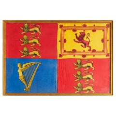
$1,475
H 25.5 in W 37.5 in D 1 in
Map of the Kingdom of Sardinia and Part of the Kingdom of Genoa, Rome
By Giovanni Maria Cassini
Located in Hamilton, Ontario
18th century map by Italian engraver Giovanni Maria Cassini (Italy 1745-1824). Map of Part of the Kingdom of Sardinia and Part of the Kingdom of Genoa: Rome. This is a hand colored a...
Category
Antique 18th Century Italian Maps
Materials
Paper

$795 Sale Price
36% Off
H 20.75 in W 25.25 in D 0.1 in
Map of the Republic of Genoa
Located in New York, NY
Framed antique hand-coloured map of the Republic of Genoa including the duchies of Mantua, Modena, and Parma.
Europe, late 18th century.
Dimension: 25...
Category
Antique Late 18th Century European Maps

“The Restaurant of the House of Representatives” Engraving by Harper
s Weekly
Located in Colorado Springs, CO
This original wood engraving is titled “The Restaurant of the House of Representatives, Washington, DC.” It was published as a double-page image, in the August 12, 1893 issue of the famous 19th century newspaper Harper’s Weekly. The print was illustrated by Charles Stanley Reinhardt.
The House Restaurant, a unique part of life in the Capitol, has been in the same location since the 1857 Capitol Expansion. Congressional members’ busy work schedule made the availability of food on site a necessity. But the restaurant also served as an informal meeting spot for members to continue conversations and deal making.
This 1893 print illustrates the convivial atmosphere. Details including elegantly dressed tables...
Category
Antique 1890s American Prints
Materials
Paper

$950
H 24 in W 29.25 in D 1 in
Map "Estuary- Mouth of the Thames"
Located in Alessandria, Piemonte
ST/426 - Antique French Map of the estuary of the Thames, map dated 1769 -
"Mape of the entrance of the Thames. Designed by filing of Navy cards fo...
Category
Antique Mid-18th Century French Other Prints
Materials
Paper

Vintage "View of the Center of Paris Taken from the Air" Lithograph Map
Located in San Diego, CA
A very stylish "View of the Center of Paris Taken from the Air" lithograph map published by the Paris Ministry of Tourism, circa early 1950s. The piece measures 27" x 43" and shows...
Category
20th Century French Mid-Century Modern Prints
Materials
Paper

$680 Sale Price
20% Off
H 43 in W 27 in D 0.25 in
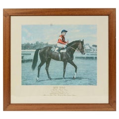
Lithograph Depicting the Horse Winner of the 1987 Italian Derby
Located in Milan, IT
Lithograph on paper made in the 1990s by the Salomone typography in Rome from a painting depicting Zaizoom winner of the 1987 Italian Derby, ridden by J. T Quinn. With frame 66.5x61 ...
Category
1990s Italian Sports Equipment and Memorabilia
Materials
Wood, Paper
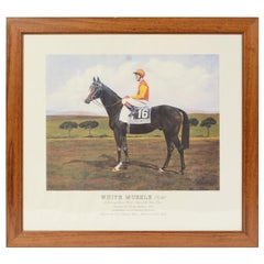
Lithograph Depicting the Horse Winner of the 1993 Italian Derby
Located in Milan, IT
Lithograph on paper made in the 1990s by the Ludovici typography in Rome from a painting depicting White Muzzle winner of the 1993 Italian Derby ridden by John Reid. With frame 66.5x...
Category
1990s Italian Sports Equipment and Memorabilia
Materials
Wood, Paper
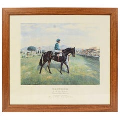
Lithograph Depicting the Horse Winner of the 1983 Italian Derby
Located in Milan, IT
Lithograph on paper made in the 1990s by the Salomone typography in Rome from a painting depicting My Top winner of the 1983 Italian Derby, ridden by Salvatore Perlanti. With frame 6...
Category
1990s Italian Sports Equipment and Memorabilia
Materials
Wood, Paper
More From This Seller
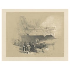
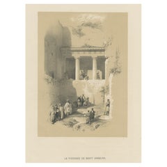
View AllOld Print of the Tombs of the Kings, Jerusalem, ca.1845
Located in Langweer, NL
Antique print titled 'Entrée du Tombeau des Rois'.
Old print of the Tombs of the Kings, Jerusalem. Made after the designs of the reknown David Roberts.
...
Category
Antique 1840s Prints
Materials
Paper
$113 Sale Price
20% Off
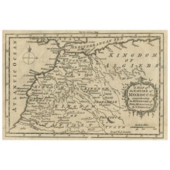
Old Map of the Kingdoms of Fez, Algiers, Segelmese, Tafilet and Morocco, ca.1760
Located in Langweer, NL
Antique map titled 'A Map of the Empire of Morocco Comprehending the Kingdoms of Fez, Morocco'.
Original antique map of the kingdoms of Fez, Algiers, Segelmese, Tafilet and Moroc...
Category
Antique 1760s British Maps
Materials
Paper
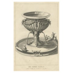
Antique Engraving of the Brass Laver in Solomon
s Temple, Jerusalem, ca.1725
Located in Langweer, NL
Antique religion print titled 'Het kopere Waschvat, Tusschen de Tente der t'zamenkomst en den altaar'.
Antique print of the Brass Laver in Solomon's Tem...
Category
Antique 1720s Prints
Materials
Paper
$227 Sale Price
20% Off
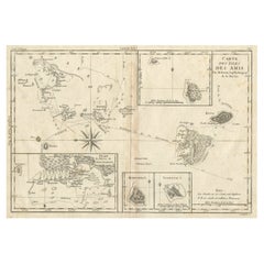
Old Map of the Kingdom of Tonga, Also Known as the Friendly Islands, ca.1780
Located in Langweer, NL
Antique print, titled: 'Carte des Isles des Amis.'
Map of the Kingdom of Tonga, also known as the Friendly Islands, and one of the last hereditary monarchies. Cook named this gro...
Category
Antique 1780s Maps
Materials
Paper
$246 Sale Price
20% Off
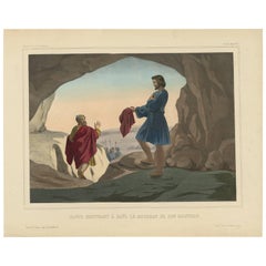
Religious Print ‘No. 8’ David Showing Saul the Tip of His Coat, circa 1840
Located in Langweer, NL
Antique print titled ‘Histoire Sainte, Ancien Testament, David montrant à Saül le Morceau de son Manteau.’ This plate shows a scene from the Old Testament; David showing Saul the tip...
Category
Antique Mid-19th Century Prints
Materials
Paper
$246 Sale Price
20% Off
Old Print of Tomb of Jacob, Israel, ca.1845
Located in Langweer, NL
Antique print titled 'Le Tombeau de Saint Jacques'. Old print of Tomb of Jacob, Israel. Made after the designs of the reknown David Roberts.
Artists and ...
Category
Antique 1840s Prints
Materials
Paper
$113 Sale Price
20% Off
Still Thinking About These?
All Recently ViewedMore Ways To Browse
Albert Willem
Antique Florida Map
Antique Map Chile
Antique Map Of Georgia
Antique Mississippi Furniture
Burgundy Map
John Speed Antique Maps
Malabar Map
Malaysia Map
Map Of Syria
Taiwan Map
Antique Chicago Maps
Dutch Bible
New Jersey 19th Century
Thailand Map
Antique Coal Mining
Antique Dutch Bible
Antique Louisiana Map