Items Similar to Bird
s Eye Plan of the Ancient City of Jerusalem Based on Old Records, c.1725
Want more images or videos?
Request additional images or videos from the seller
1 of 9
Bird
s Eye Plan of the Ancient City of Jerusalem Based on Old Records, c.1725
$772.20
£565.92
€640
CA$1,059.88
A$1,119.94
CHF 602.31
MX$13,407.74
NOK 7,546.22
SEK 6,911.24
DKK 4,875.65
About the Item
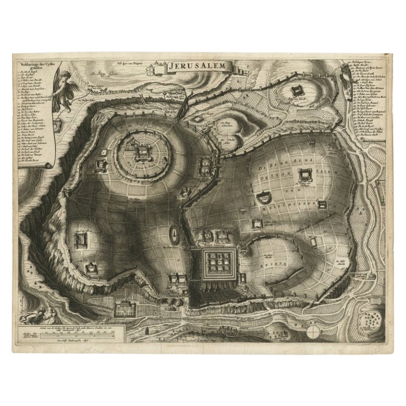
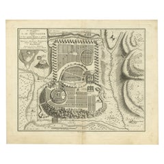
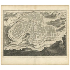
Antique map titled 'Beschryving van het oude Jeruzalem volgens Villalpandus.'
Bird's eye plan of the ancient city of Jerusalem based on Villalpando's foundation map. The plan shows only the major religious sites, uncluttered by habitations and is beautifully engraved to show the surrounding topography. This plate originates from: 'Het algemeen groot historisch, oordeelkundig, chronologisch, geografisch, en letterlyk naam- en woord-boek, van den gantschen H. Bijbel. Dienende tot de gedenk-stukken der Jooden en andere oudheden, ter opheldering der H. Schrift ... Nu in't Nederduitsch overgezet, merkelyk vermeerdert, en met aanmerkingen verrykt, door Mattheus Gargon.' and it's additons: 'Byvogzel tot het algemeen groot ... Naam- en woord-boek ... En nu in zuiver Nederduitsch overgezet, merkelyk vermeerdert, en metv aanmerkingen verrykt, door Jakob van Ostade en Arn. Henr. Westerhovius.', by Augustines Calmet, published in Leiden, Amsterdam, by Samuel Luchtmans, R.
J. Wetstein en Smith 1725-1731. This is a reknown encyclopaedic dictionary on all aspects of the history, geography and culture of the Bible and Biblical times. This Dutch translation originates from Calmet's work in French including: 'Commentaire littéral sur tous les livres de l'Ancien et du Nouveau Testament ...', first published in Paris in 1707. Artists and Engravers: Made by 'Antoine Augustin Calmet' after an anonymous artist. Author: Antoine Augustin Calmet (1672-1757), French Benedictine. Translation by: translation by Mattheus Gargon (1661-1728), a minister in Vlissingen. Engravings in this work by A. de Putter, F. van Bleyswyk, M. Pool, Ph. van Gunst, etc.
Artist: Made by 'Antoine Augustin Calmet' after an anonymous artist. Author: Antoine Augustin Calmet (1672-1757), French Benedictine. Translation by: translation by Mattheus Gargon (1661-1728), a minister in Vlissingen. Engravings in this work by A. de Putter, F. van Bleyswyk, M. Pool, Ph. van Gunst, etc.
Condition: Good, given age. A few minor crinkles. Original middle fold as issued. General age-related toning and/or occasional minor defects from handling. Please study image carefully.
Date: c.1725
Overall size: 51.3 x 42.5 cm.
Image size: 43.7 x 30.5 cm.
- Dimensions:Height: 20.2 in (51.3 cm)Width: 16.74 in (42.5 cm)Depth: 0.01 in (0.2 mm)
- Materials and Techniques:Paper,Engraved
- Place of Origin:
- Period:
- Date of Manufacture:circa 1725
- Condition:Condition: Good, given age. A few minor crinkles. Original middle fold as issued. General age-related toning and/or occasional minor defects from handling. Please study image carefully.
- Seller Location:Langweer, NL
- Reference Number:Seller: PCT-614571stDibs: LU3054326362142
About the Seller
5.0
Recognized Seller
These prestigious sellers are industry leaders and represent the highest echelon for item quality and design.
Platinum Seller
Premium sellers with a 4.7+ rating and 24-hour response times
Established in 2009
1stDibs seller since 2017
2,852 sales on 1stDibs
Typical response time: 1 hour
- ShippingRetrieving quote...Shipping from: Langweer, Netherlands
- Return Policy
More From This Seller
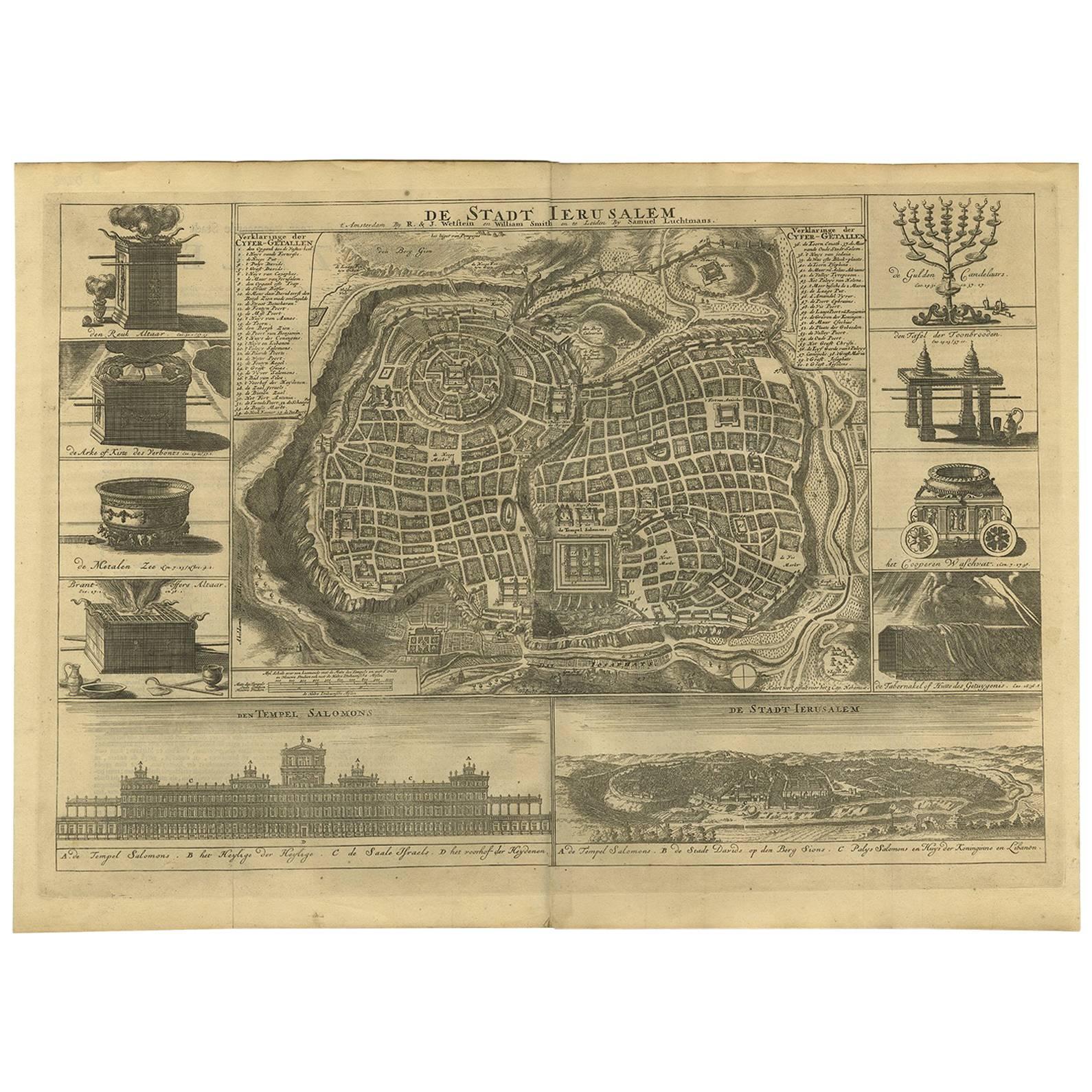
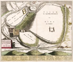
View AllAntique Detailed Map of Jerusalem in Israël with Extensive Key and Scale, 1698
Located in Langweer, NL
Antique map titled 'Jerusalem.'
Plan of the ancient city of Jerusalem. With extensive key and scale. Source unknown, to be determined.
Artists and Engravers: Made by 'Cornelis de...
Category
Antique 17th Century Dutch Maps
Materials
Paper

$627 Sale Price
20% Off
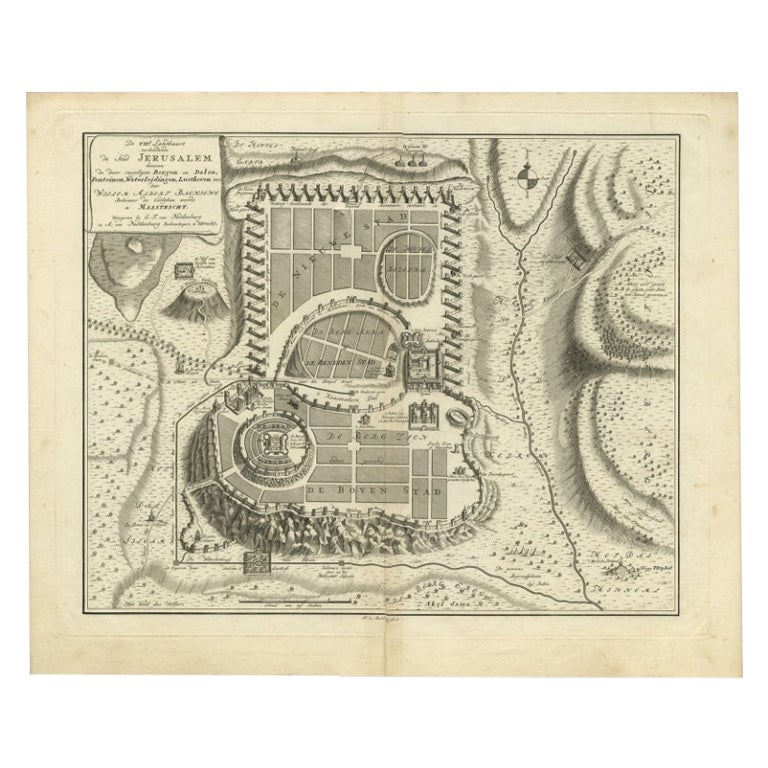
Bird
s-Eye Plan of Jerusalem in Israël, a Rare Original Engraving, 1750
Located in Langweer, NL
Antique map titled 'De VIIde Landkaart Verbeeldende de Stad Jerusalem Beneven de daar Omgelegen Bergen en Dalen (..).'
Bird's-eye plan of Jerusalem in Israel. This map shows the mo...
Category
Antique 18th Century Maps
Materials
Paper
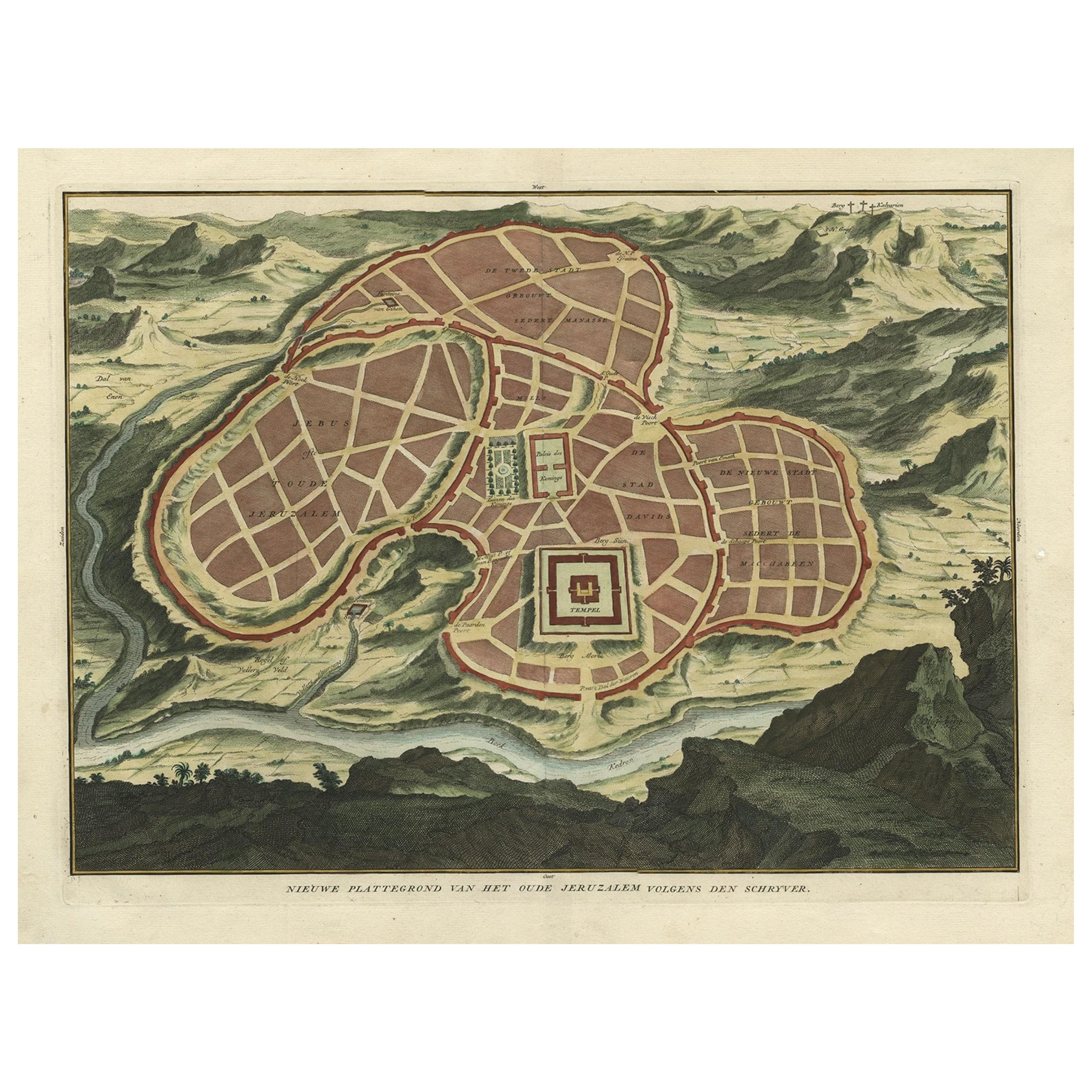
Antique Map of Ancient Jerusalem, depicting The Temple of Solomon, c.1725
Located in Langweer, NL
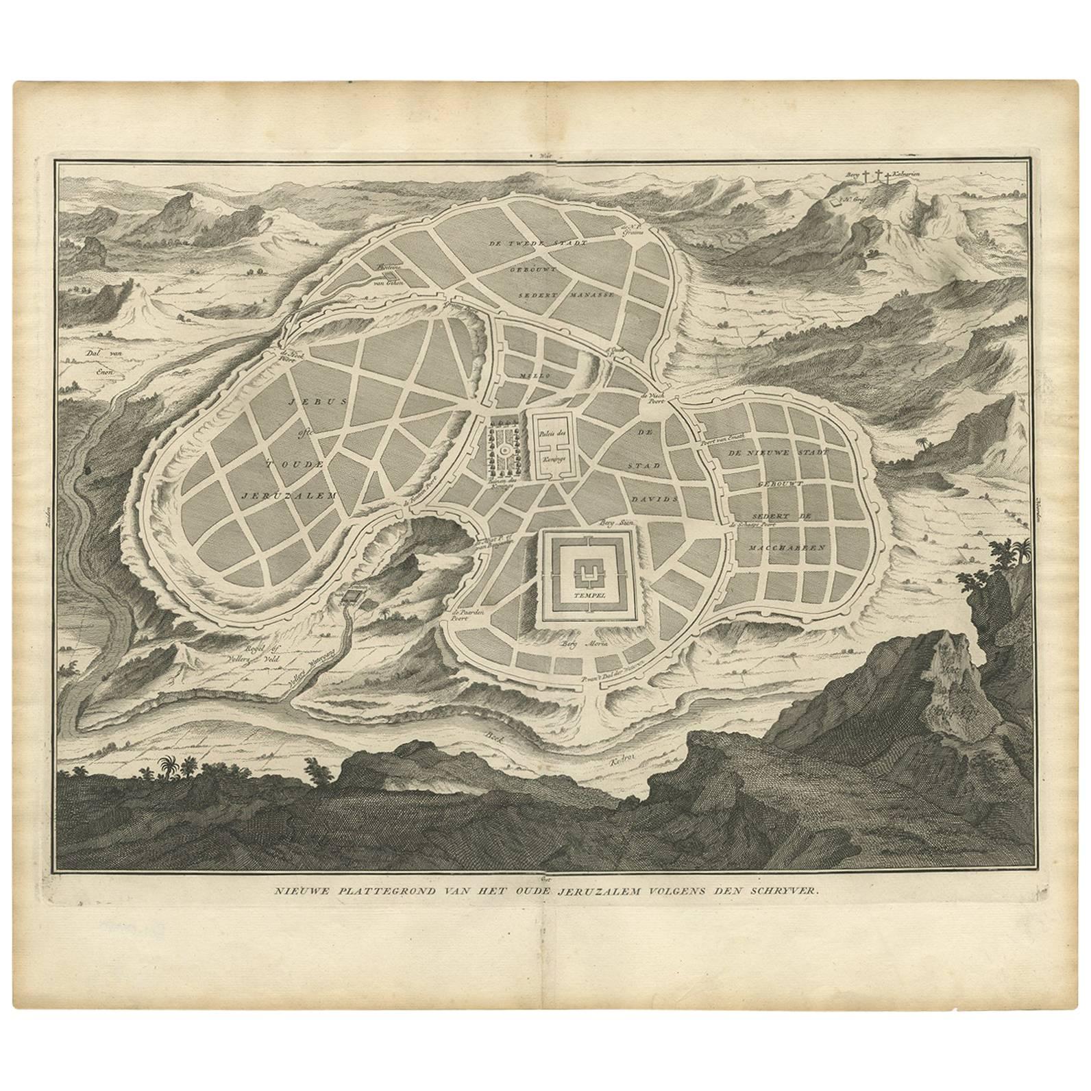
Antique map titled 'Nieuwe Plattegrond van het Oude Jeruzalem Volgens den Schryver.'
Bird's-eye view of the ancient city of Jerusalem shows its divisions with prominent depictions ...
Category
Antique 18th Century French Maps
Materials
Paper

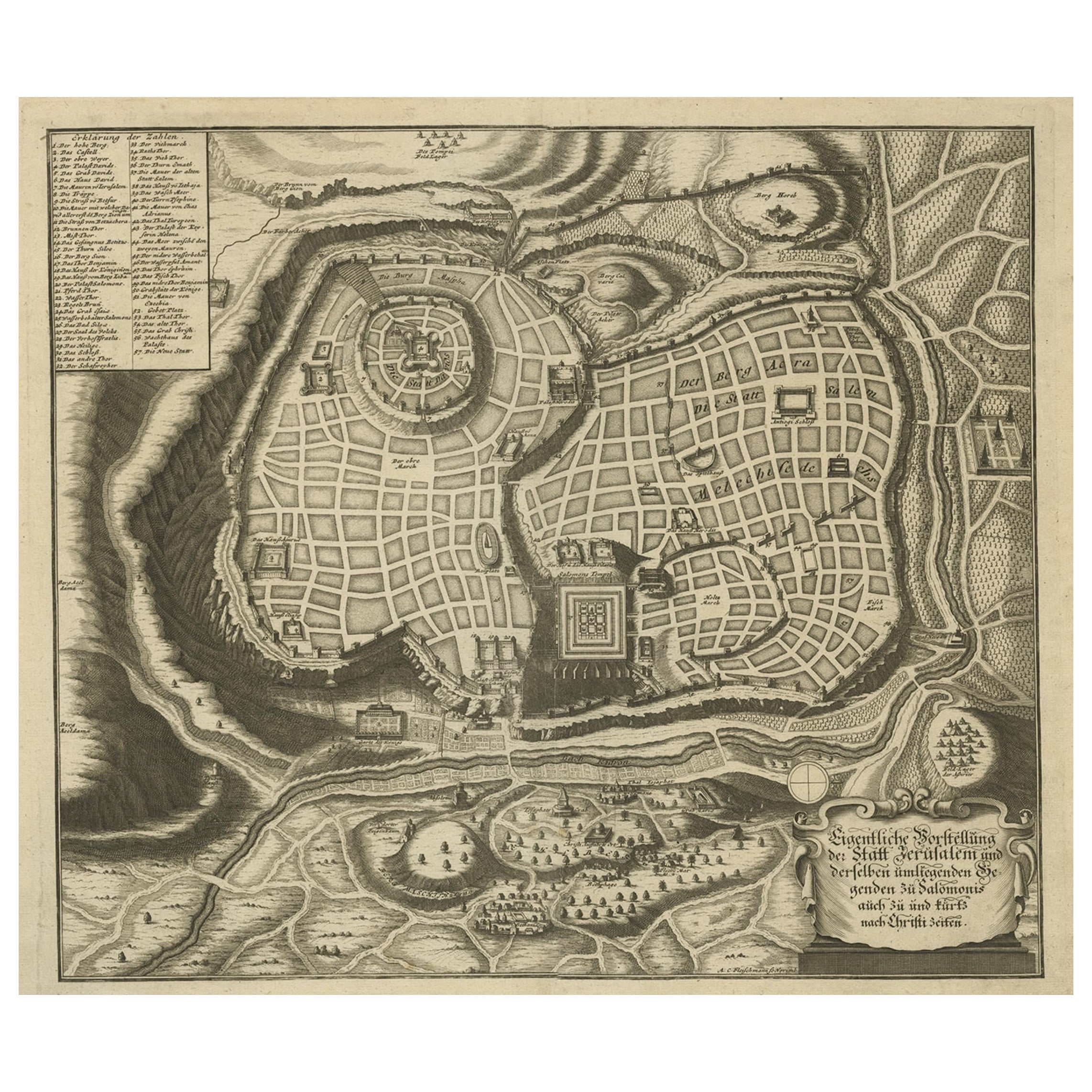
Rare Town Plan of Jerusalem, Includes an Extensive Key to Locations etc, 1708
Located in Langweer, NL
Antique map titled 'Eigentliche Vorstellung der Statt Jerusalem und derselben umliegenden Gegenden zu Salomonis auch zu und kurtz nach Christi Zeiten.'
Rare town plan...
Category
Antique Early 1700s Religious Items
Materials
Paper
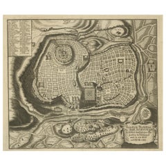
Antique Map of the Ancient City of Jerusalem by A. Calmet, 1725
Located in Langweer, NL
Antique map, titled: 'Nieuwe Plattegrond van het Oude Jeruzalem Volgens den Schryver.' - Bird's-eye view of the ancient city of Jerusalem shows its divisions with prominent depiction...
Category
Antique Early 18th Century French Prints
Materials
Paper
Antique Bible Plan of Ancient Jerusalem, 1743
Located in Langweer, NL
This plan originates from ‘Biblia Sacra, dat is, de H. Schriftuer van het Oude, en het Nieuwe Testament, naer de laetste Roomsche keure der gemeine Latijnsche overzettinge, in nederd...
Category
Antique Mid-18th Century Maps
Materials
Paper

$819 Sale Price
38% Off
You May Also Like
Map of Biblical Jerusalem
Located in New York, NY
Original copper engraving hand-colored at the time of publication. Nuremberg, 1720.
Category
1720s Prints and Multiples
Materials
Paper
Original Antique Map or City Plan of Geneva, Switzerland. Circa 1835
Located in St Annes, Lancashire
Nice map of Geneva
Drawn and engraved by J.Dower
Published by Orr & Smith. C.1835
Unframed.
Free shipping
Category
Antique 1830s English Maps
Materials
Paper

18th Century Map of Rome
Surrounding Vicinity
Located in New Orleans, LA
Intriguing framed map of Rome and the surrounding vicinity featuring detailed cartography, ornamental illustrations, and text index at the bottom. A great, historical conversation pi...
Category
Antique 18th Century Italian Antiquities
Materials
Paper
1597 German Map of Alexandria by Georg Braun and Frans Hogenberg
By Georg Braun and Frans Hogenberg
Located in Chapel Hill, NC
1597 Map of Alexandria by Georg Braun and Frans Hogenberg, Germany. From "Civitas Orbis Terrarum", part 2, published in Cologne by Bertram Buchholz. Printed in 2 parts. Title: "Alexa...
Category
Antique 16th Century German Renaissance Maps
Materials
Paper

$480 Sale Price
20% Off
Vienna, Austria: A Large 17th Century Hand-Colored Map by Sanson and Jaillot
By Nicolas Sanson
Located in Alamo, CA
This large 17th century hand-colored map of Vienna, Austria and the surrounding countryside and villages entitled "Plan de la Ville de Vienne en Austrich...
Category
Antique 1690s French Maps
Materials
Paper

1748 Map of Richmond Upon Thames by John Roque
Located in Gloucestershire, GB
A 1748 map of Richmond-Upon-Thames by famed surveyor and cartographer, John Roque. Placed in a simple black and gilt frame. The map is in fair condition but there are small sections ...
Category
Antique Mid-18th Century English Maps
Materials
Wood, Paper

More Ways To Browse
Antique Putters
Antique Maps Of Cape Of Good Hope
Antique Maps Of Texas
Antique Virginia Furniture
Otto Petri
American West Antiques
Antique Furniture Brunswick
Antique Map Ceylon
Antique Map Of The Philippines
Antique Mississippi Map
Celestial Map
Map Of Middle East
17th Century American Furniture
Afghanistan Map
Antique Celestial Maps
Antique Maps Virginia
Hand Drawn Map
Map Of Israel