Items Similar to Bolsward
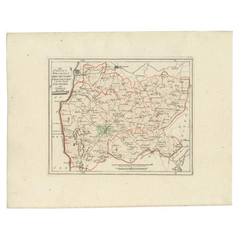
Sneek, Westergo (Friesland) – von Reilly antique map, 1791

Want more images or videos?
Request additional images or videos from the seller
1 of 10
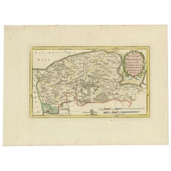
Bolsward
Sneek, Westergo (Friesland) – von Reilly antique map, 1791
$420.67
£311.60
€350
CA$575.46
A$627.22
CHF 331.60
MX$7,550.50
NOK 4,208.88
SEK 3,858.68
DKK 2,666.81
About the Item
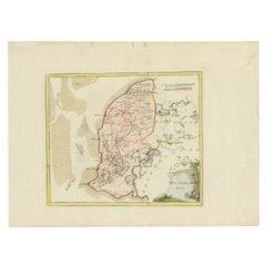
Title: Bolsward
Sneek, Westergo (Friesland) – von Reilly antique map, 1791
Description:
Crisp late-18th-century map of the Westergo region in Friesland focusing on the “drey mittlere Grietenyen” (three central districts) with the towns of Bolsward and Sneek. Published in Vienna in 1791 for Franz Johann Josef von Reilly’s atlas “Schauplatz der fünf Theile der Welt,” the sheet shows a dense web of dikes, waterways, roads and villages across Southwest Friesland. The city plans of Sneek and Bolsward are set among surrounding polders and lakes; neighboring districts and borders are traced in contemporary outline color. A neat title cartouche at upper left and dual distance scales (Deutsche Meilen and Holländische Meilen) complete the composition.
Von Reilly (1766–1820) was a Vienna-based dealer, publisher and geographer whose compact atlases are prized for clear, up-to-date regional mapping. The engraving here is by Ignaz Alberti (Albrecht, 1760–1794), whose fine line and lettering give excellent legibility. With its wide margins, clear plate impression and original hand color, this is a particularly attractive example for collectors of Friesland and the northern Netherlands or of Austrian Enlightenment cartography. Its modest format also makes it ideal for pairing with other provincial sheets from the same series.
Condition report:
Good, with original contemporary outline hand-color. Light, even age toning; a few tiny spots and minor handling to wide margins; blank verso. Strong visible plate mark; no folds, tears or repairs observed.
Framing tips:
Use an ivory or soft-cream mount to brighten the sheet, with a thin red inner line echoing the outline color. A dark wood or ebonized frame gives classic contrast; for a lighter look choose warm oak or maple.
Technique: Copper engraving with contemporary outline hand-colour
Maker: Franz J. J. von Reilly (engr. Ignaz Alberti), Vienna, 1791
- Dimensions:Height: 11.82 in (30 cm)Width: 15.16 in (38.5 cm)Depth: 0.01 in (0.2 mm)
- Materials and Techniques:Paper,Engraved
- Place of Origin:
- Period:
- Date of Manufacture:1791
- Condition:Good, with original contemporary outline hand-color. Light, even age toning; a few tiny spots and minor handling to wide margins; blank verso. Strong visible plate mark; no folds, tears or repairs observed.
- Seller Location:Langweer, NL
- Reference Number:Seller: BG-002321stDibs: LU3054327871622
About the Seller
5.0
Recognized Seller
These prestigious sellers are industry leaders and represent the highest echelon for item quality and design.
Platinum Seller
Premium sellers with a 4.7+ rating and 24-hour response times
Established in 2009
1stDibs seller since 2017
2,811 sales on 1stDibs
Typical response time: 1 hour
- ShippingRetrieving quote...Shipping from: Langweer, Netherlands
- Return Policy
More From This Seller
View AllAntique Map of the Region of Bolsward and Sneek by Von Reilly, 1791
Located in Langweer, NL
Antique map titled 'Der Provinz Westergo drey mittlere Grietenyen mit der Stadt Bolsward und Sneek'. Map of the region of Bolsward and Sneek, Friesland, the Netherlands. This map org...
Category
Antique 18th Century Maps
Materials
Paper
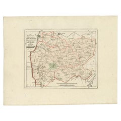
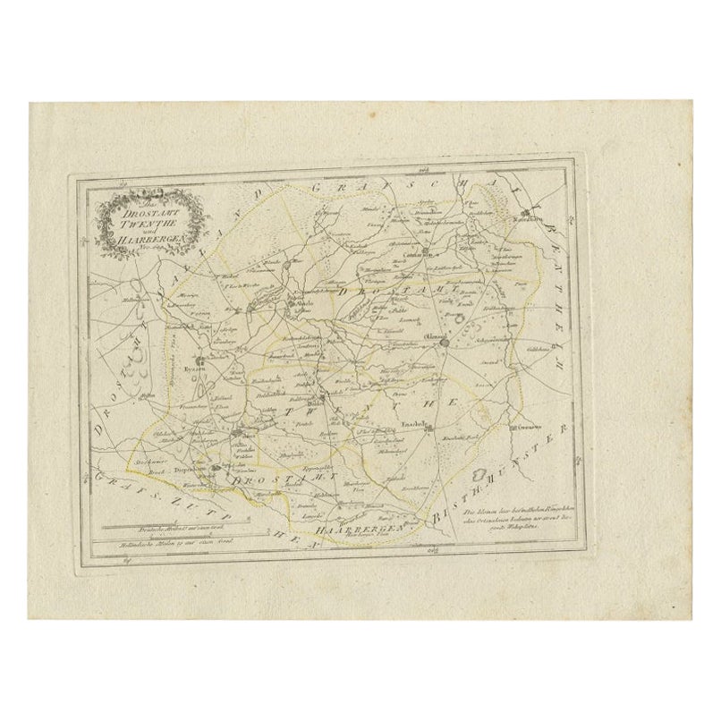
Antique Map of Part of Overijssel by Von Reilly, 1792
Located in Langweer, NL
Antique map titled 'Das Drostamt Twenthe und Haarbergen'. This map depicts part of The Netherlands (Overijssel). This map originates from 'Schauplatz der fünf Theile der Welt' publis...
Category
Antique 18th Century Maps
Materials
Paper
$120 Sale Price
20% Off
Rare 1791 von Reilly Map of Franeker and Harlingen, Friesland, Netherlands
Located in Langweer, NL
Antique Map of Franeker and Harlingen by von Reilly, 1791
Fine original map titled Der Provinz Westergo vier nördliche Grietenyen mit der Stadt Franeker und Harlingen, published in ...
Category
Antique 18th Century Austrian Maps
Materials
Paper

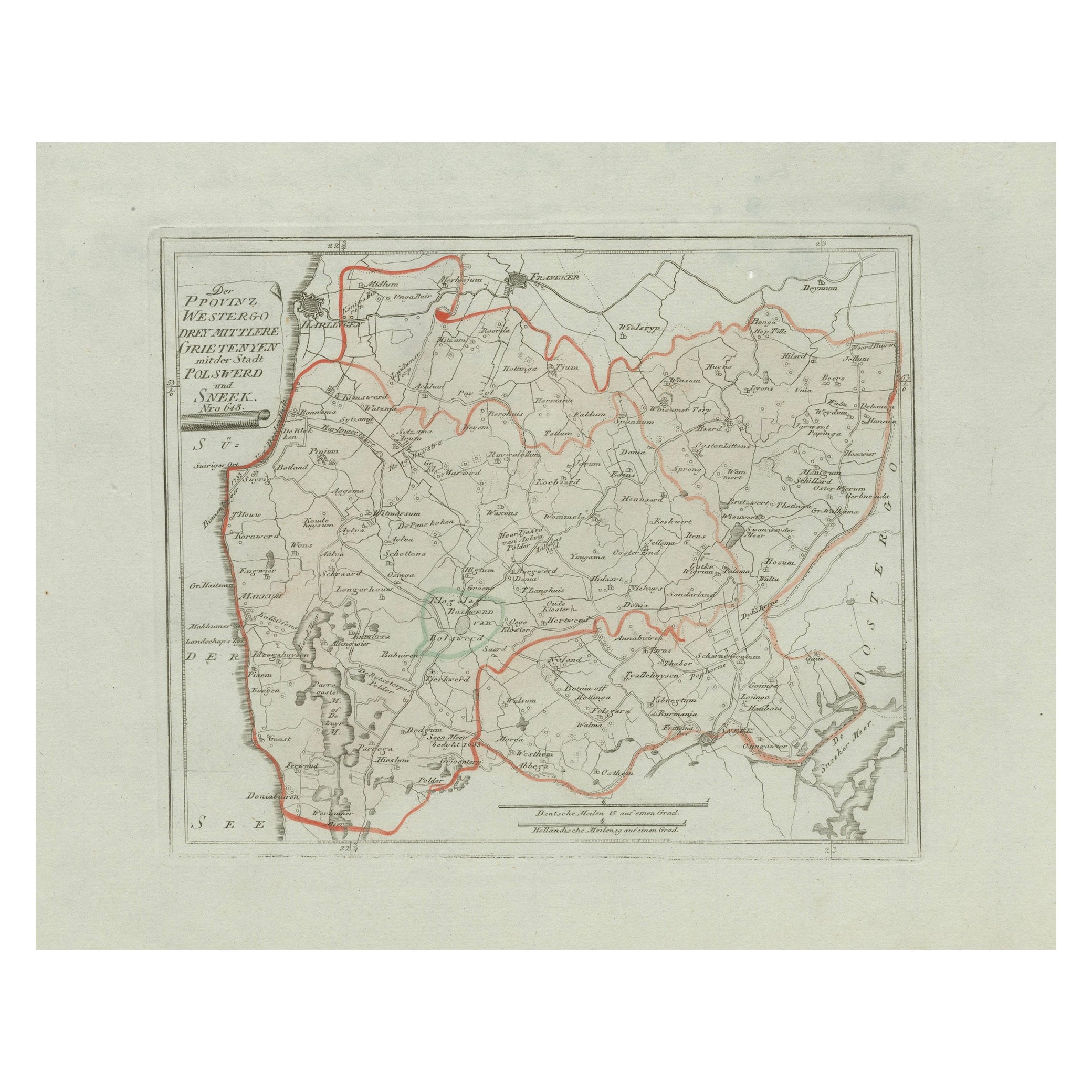
Antique Map of Sneek and Bolsward, Friesland – Dutch Provincial Map, 1791
Located in Langweer, NL
Antique Map of Sneek and Bolsward, Friesland by von Reilly, 1791
Original engraved map titled Der Provinz Westergo drey mittlere Grietenyen, mit der Stadt Bolsward und Sneek No. 641...
Category
Antique 18th Century Austrian Maps
Materials
Paper

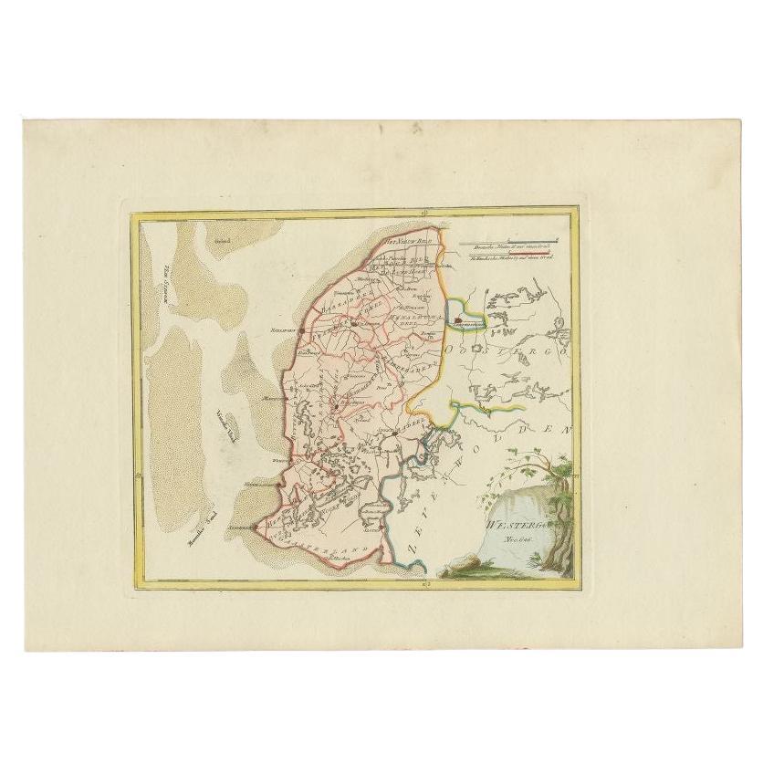
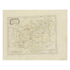
Antique Map of Westergo in Friesland, 1791
Located in Langweer, NL
Antique map titled 'Westergo'. Map of the Westergo region, Friesland, the Netherlands. This map orginates from 'Schauplatz der fünf Theile der Welt'.
Artists and Engravers: Franz...
Category
Antique 18th Century Maps
Materials
Paper
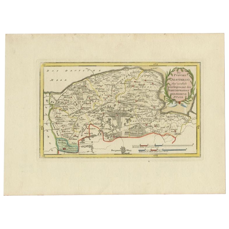
Antique Map of the Region of Leeuwarden and Dokkum in The Netherlands, 1791
Located in Langweer, NL
Antique map titled 'Der Provinz Oostergo fünf nördliche Grietenyen mit der Stadt Leeuwaarden und Dokkum'. Map of the region of Leeuwarden and Dokkum, Friesland, the Netherlands. This...
Category
Antique 18th Century Maps
Materials
Paper
$151 Sale Price
20% Off
You May Also Like
1752 Vaugoundy Map of Flanders : Belgium, France, and the Netherlands, Ric.a002
Located in Norton, MA
Large Vaugoundy Map of Flanders:
Belgium, France, and the Netherlands
Colored -1752
Ric.a002
Description: This is a 1752 Didier Robert de Vaugondy map of Flanders. The map de...
Category
Antique 17th Century Unknown Maps
Materials
Paper

Original Antique English County Map, Cambridgeshire, J
C Walker, 1851
Located in St Annes, Lancashire
Great map of Cambridgeshire
Original colour
By J & C Walker
Published by Longman, Rees, Orme, Brown & Co. 1851
Unframed.
Category
Antique 1850s English Other Maps
Materials
Paper

Derbyshire, English County Antique map, 1847
By Isaac Slater
Located in Melbourne, Victoria
Steel-engraved map with original outline colouring by Isaac Slater. A detailed engraved map of the English county with title, scale, and key. Decorated with an uncoloured engraved vi...
Category
19th Century Naturalistic Landscape Prints
Materials
Engraving
1635 Willem Blaeu Map of Northern France"Comitatvs Bellovacvm" Ric.a08
Located in Norton, MA
1635 Willem Blaeu map of northern France, entitled.
"Comitatvs Bellovacvm Vernacule Beavvais,"
Colored
Ric.a008
“COMITATVS BELLOVACVM…” Amsterdam: W...
Category
Antique 17th Century Unknown Maps
Materials
Paper

1771 Bonne Map of Poitou, Touraine and Anjou, France, Ric.a015
Located in Norton, MA
1771 Bonne Map of Poitou,
Touraine and Anjou, France
Ric.a015
1771 Bonne map of Potiou, Touraine and Anjou entitled "Carte des Gouvernements D'Anjou et du Saumurois, de la Touraine, du Poitou,du Pays d'aunis, Saintonge?Angoumois,"
Carte des gouvernements d'Anjou et du Saumurois, de la Touraine, du Poitou, du Pays d'Aunis, Saintonge-Angoumois. Projettee et assujettie au ciel par M. Bonne, Hyd. du Roi. A Paris, Chez Lattre, rue St. Jacques a la Ville de Bord(ea)ux. Avec priv. du Roi. 1771. Arrivet inv. & sculp., Atlas moderne ou collection de cartes sur toutes...
Category
Antique 17th Century Unknown Maps
Materials
Paper

Original Antique English County Map, Buckinghamshire, J
C Walker, 1851
Located in St Annes, Lancashire
Great map of Buckinghamshire
Original colour
By J & C Walker
Published by Longman, Rees, Orme, Brown & Co. 1851
Unframed.
Category
Antique 1850s English Other Maps
Materials
Paper

More Ways To Browse
Franz Joseph
Johann Baptist Homann On Sale
Magellan Map
Map Of Puerto Rico
Map Ukraine
Papua New Guinea Antique Map
Serbia Antique Map
Stanford Antique Furniture
Tipu Sultan
Used Office Furniture Cornwall
Vintage Wooden Roller
Albania Antique Map
Ancient Bible
Antique Bermuda Furniture
Antique Constellation Map
Antique Map Burgundy
Antique Map Of Hawaii
Antique Maps Of Long Island