Items Similar to Bonne Map of Philippines, Formosa, Siam, Indochina
South China, 1780


Want more images or videos?
Request additional images or videos from the seller
1 of 12
Bonne Map of Philippines, Formosa, Siam, Indochina
South China, 1780
$347.05
£259.81
€290
CA$477.76
A$522.29
CHF 276.31
MX$6,250.02
NOK 3,515.70
SEK 3,218.27
DKK 2,209.44
About the Item
Bonne Map of Philippines, Formosa, Siam, Indochina
South China, 1780
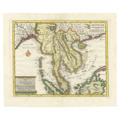
Les Isles Philippines, celle de Formose, le Sud de la Chine, les Royaumes de Tunkin, de Cochinchine, de Camboge, de Siam des Laos.
Original 1780 copperplate-engraved map with hand coloring by renowned French cartographer Rigobert Bonne (1727–1795), hydrographer to the French Navy. This detailed and elegant map spans the Philippines, Formosa (Taiwan), southern China, and much of mainland Southeast Asia, including the kingdoms of Siam (Thailand), Laos, Cambodia, Cochinchina, and Tonkin (Vietnam).
Praised for its geographical accuracy and refined engraving style, Bonne’s map features coastlines, mountain ranges, rivers, and settlements, along with inset maps of the Isle de Guam and surrounding Pacific islands. The use of color and shading highlights territorial divisions and topography.
A fine and historically significant map, now a valued reference for historians, collectors, and researchers of 18th-century Southeast Asia.
Condition: Good condition. Original hand coloring. Light age toning and minor foxing to margins. Centerfold as issued. A few small edge nicks not affecting image. Paper remains strong with good plate impression and no restoration.
Framing Tips:
- Use UV-protective glass to prevent fading of hand coloring.
- Acid-free mat and backing to preserve paper quality.
- Float-mount if edges or plate mark should remain visible.
- Choose a classic wooden or gilt frame to match the antique aesthetic.
- Keep away from direct sunlight and humidity.
- Dimensions:Height: 10.24 in (26 cm)Width: 14.57 in (37 cm)Depth: 0.01 in (0.2 mm)
- Materials and Techniques:Paper,Engraved
- Period:1780-1789
- Date of Manufacture:1780
- Condition:Good condition. Original hand coloring. Light age toning and minor foxing to margins. Centerfold as issued. A few small edge nicks not affecting image. Paper remains strong with good plate impression and no restoration.
- Seller Location:Langweer, NL
- Reference Number:Seller: BGSH-0301stDibs: LU3054344556652
About the Seller
5.0
Recognized Seller
These prestigious sellers are industry leaders and represent the highest echelon for item quality and design.
Platinum Seller
Premium sellers with a 4.7+ rating and 24-hour response times
Established in 2009
1stDibs seller since 2017
2,793 sales on 1stDibs
Typical response time: <1 hour
- ShippingRetrieving quote...Shipping from: Langweer, Netherlands
- Return Policy
More From This Seller
View AllAntique Map of the Philippines, Taiwan and Surroundings by Bonne
1780
Located in Langweer, NL
Antique map titled 'Les Isles Philippines, celle de Formose, le Sud de la Chine, les Royaumes de Tunkin, de Cochinchine, de Cambode, de Siam des Laos, avec partie de Pegu et D'Ava'. ...
Category
Antique Late 18th Century French Maps
Materials
Paper
$430 Sale Price
20% Off
Antique Map of Southeast Asia by J. Ottens, 1710
Located in Langweer, NL
Antique map titled 'Le Royaume de Siam avec Les Royaumes Qui Luy sont Tributaries'. Influential map of Southeast Asia. Ottens incorporated information provided by the French Jesuits ...
Category
Antique Early 18th Century Maps
Materials
Paper

$1,008 Sale Price
41% Off
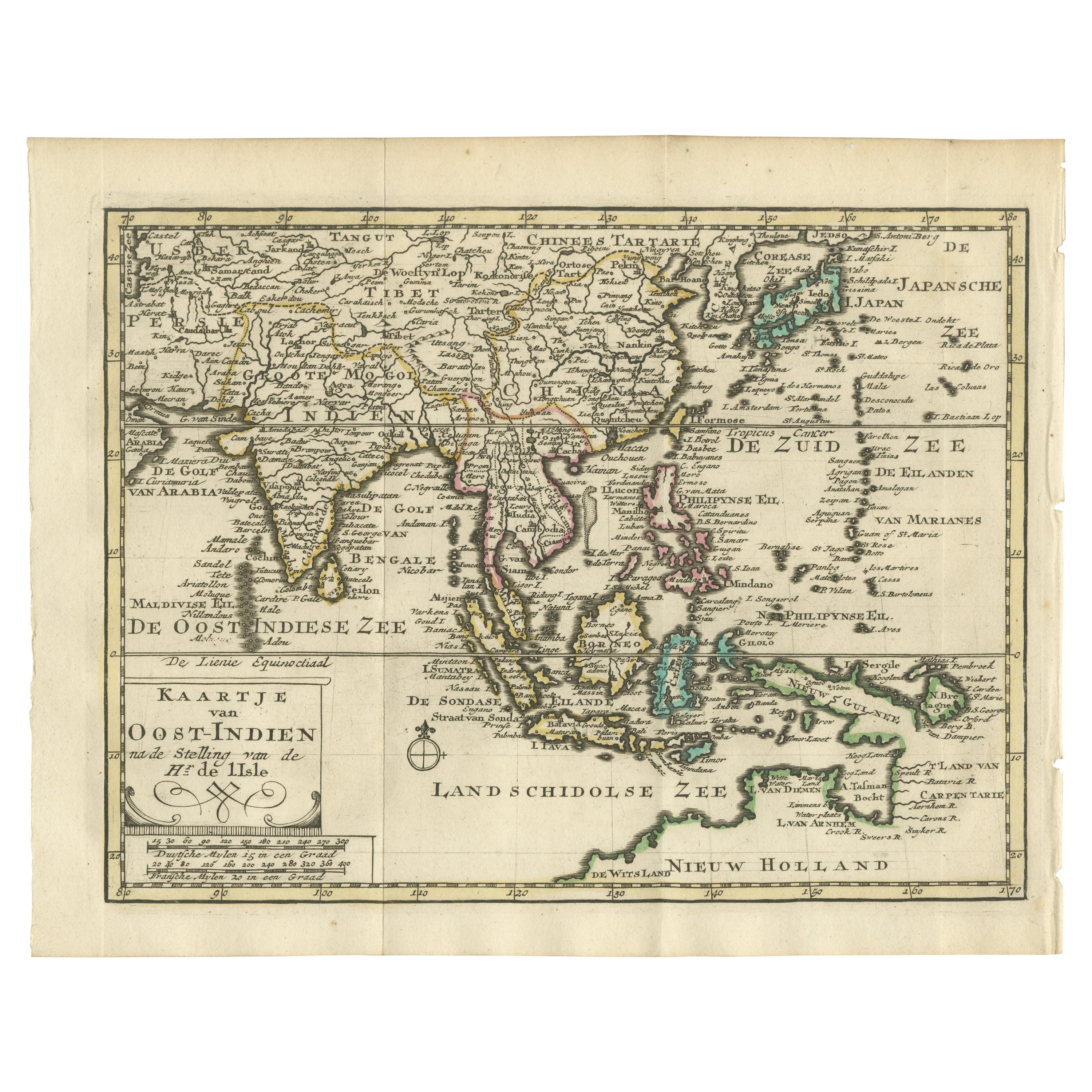
Authentic Old Map of Southeast Asia with Original Border Coloring, 1745
Located in Langweer, NL
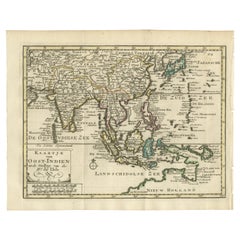
Title: "Kaartje van Oost-Indien na de stelling van den Heer Guillaume de L'Isle"
Translates to "Map of the East-Indies based on the work of Mr. Guillaume de L'Isle." Guillaume de L...
Category
Antique 1740s Maps
Materials
Paper
$421 Sale Price
20% Off
Large Antique Map of Asia including All of Southeast Asia, c.1792
Located in Langweer, NL
Antique map titled 'L' Asie Divisee en ses Empires, Royaumes, et Etats'. Attractive, large map of Asia including all of Southeast Asia. The cartography is archaic for the period with...
Category
Antique 18th Century Maps
Materials
Paper

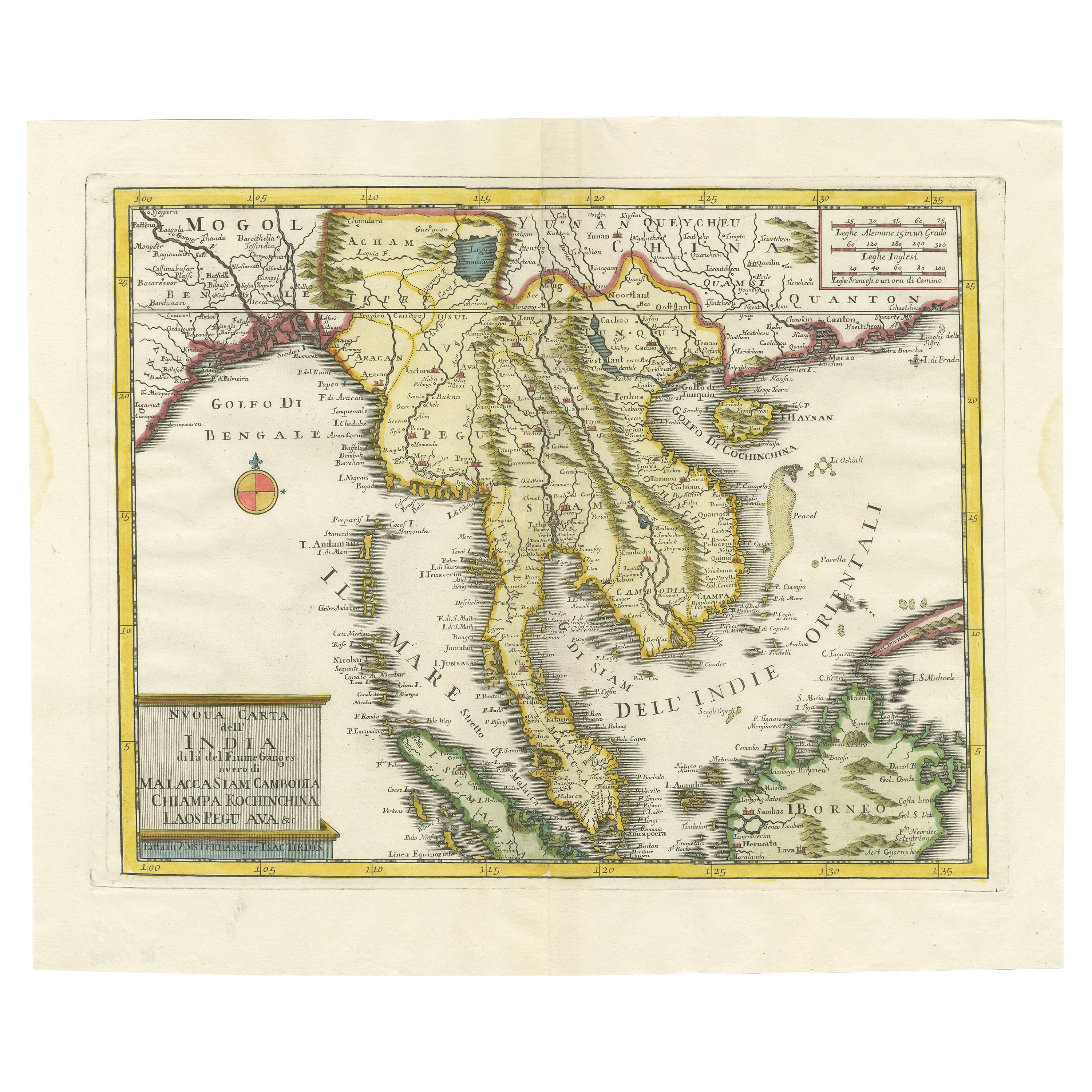
Antique Map of the Region Centered on the Malay Peninsula by Tirion
c.1760
Located in Langweer, NL
Antique map titled 'Nuova Carta dell' India (..)'. Decorative map of the region centered on the Malay Peninsula and extending from the Straits of Singapore, Malacca and Borneo in the South to China in the east and the Bay of Bengal...
Category
Antique Mid-18th Century Maps
Materials
Paper
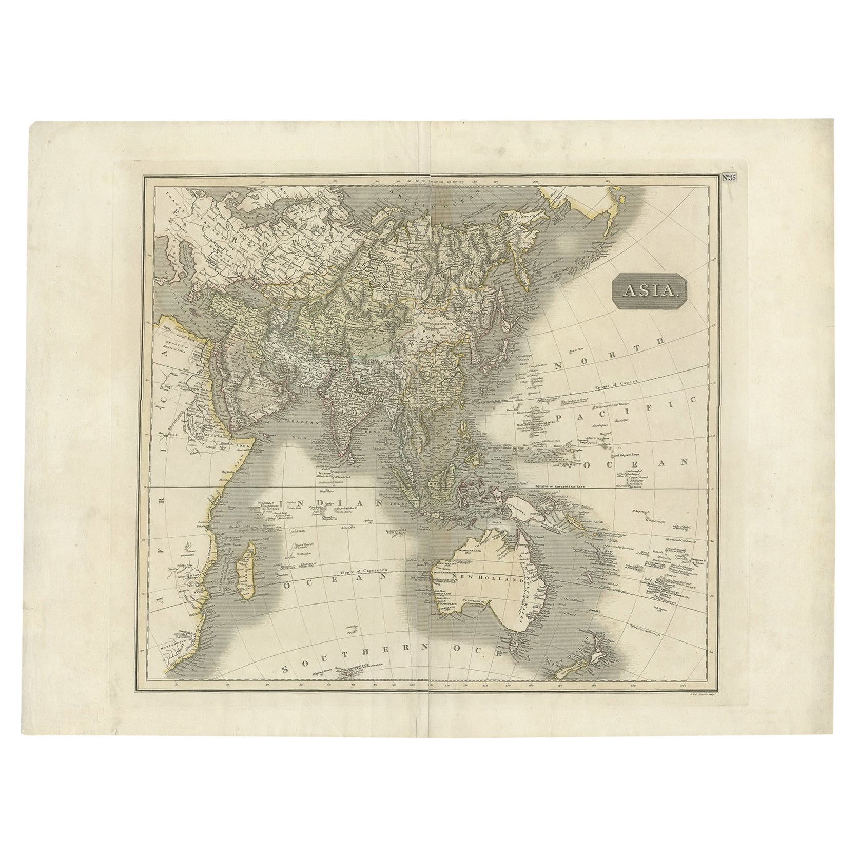
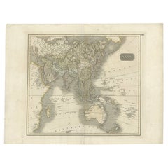
Antique Map of Asia Depicting Asia and Australia, c.1814
Located in Langweer, NL
Antique map titled 'Asia'. This map depicts Asia and Australia. Engraved by J. and G. Menzies and issued for Thomson's 'New General Atlas'.
Artists and Engravers: John Thomson (1...
Category
Antique 19th Century Maps
Materials
Paper
You May Also Like
Antique French Map of Asia Including China Indoneseia India, 1783
Located in Amsterdam, Noord Holland
Very nice map of Asia. 1783 Dedie au Roy.
Additional information:
Country of Manufacturing: Europe
Period: 18th century Qing (1661 - 1912)
Condition: Overall Condition B (Good Used)...
Category
Antique 18th Century European Maps
Materials
Paper

$486 Sale Price
40% Off
Antique 1803 Italian Map of Asia Including China Indoneseia India
Located in Amsterdam, Noord Holland
Antique 1803 Italian Map of Asia Including China Indoneseia India
Very nice map of Asia. 1803.
Additional information:
Type: Map
Country of Manufacturing: Europe
Period: 19th centu...
Category
Antique 19th Century European Maps
Materials
Paper

$438 Sale Price
39% Off
Original Antique Map of South East Asia by Thomas Clerk, 1817
Located in St Annes, Lancashire
Great map of South East Asia
Copper-plate engraving
Drawn and engraved by Thomas Clerk, Edinburgh.
Published by Mackenzie And Dent, 1817
Unframed.
Category
Antique 1810s English Maps
Materials
Paper

Super Rare Antique French Map of Chine and the Chinese Empire, 1780
Located in Amsterdam, Noord Holland
Super Rare Antique French Map of Chine and the Chinese Empire, 1780
Very nice map of Asia. 1780 Made by Bonne.
Additional information:
Type: Map
...
Category
Antique 18th Century European Maps
Materials
Paper

$438 Sale Price
49% Off
Large Original Vintage Map of S.E Asia, with a Vignette of Singapore
Located in St Annes, Lancashire
Great map of South East Asia
Original color. Good condition
Published by Alexander Gross
Unframed.
Category
Vintage 1920s English Maps
Materials
Paper

Original Antique Map of China, Arrowsmith, 1820
Located in St Annes, Lancashire
Great map of China
Drawn under the direction of Arrowsmith
Copper-plate engraving
Published by Longman, Hurst, Rees, Orme and Brown, 1820
Unfr...
Category
Antique 1820s English Maps
Materials
Paper

More Ways To Browse
Fading Glass
Philippines Antique
Leather Pouf And Ottomans
Low Side Tables
Set Of Four Italian Dining Chairs
Silk Runner Carpet
3x5 Rugs
Italian Lacquer Dining Room Sets
Round Brass Table
Round Table Base
Belgian Antiques
Cream Soup
Early English Silver
James Bond
Paisley Rugs and Carpets
Antique Pagoda
Black And Chrome Lounge Chair
Ceramic 1960s Italy