Items Similar to British Isles – England, Scotland
Ireland Antique Map, Bonne c1780


Want more images or videos?
Request additional images or videos from the seller
1 of 9
British Isles – England, Scotland
Ireland Antique Map, Bonne c1780
$379.70
£283.46
€320
CA$527.52
A$567.42
CHF 303.24
MX$6,688.25
NOK 3,823.21
SEK 3,495.14
DKK 2,438.76
About the Item
British Isles – England, Scotland
Ireland Map, Bonne c1780
Description:
This elegant map depicts England, Scotland, and Ireland with remarkable detail, showing counties, rivers, and coastal features. Produced by Rigobert Bonne, it reflects late-18th-century French geographic scholarship and political interest in the British Isles. The engraving is crisp and balanced, making it ideal for both collectors and interior display.
The map is offered unframed, preserving the sheet in its original, untouched state.
Condition: Good condition. Light toning, original centerfold, minor margin wear.
Framing tips: Dark brown or black frame with a wide cream mat enhances contrast.
Keywords: British Isles map, England Scotland Ireland, antique UK map, 18th century cartography, Rigobert Bonne
Technique: Copper engraving
Maker: Rigobert Bonne, France, circa 1780
- Dimensions:Height: 16.15 in (41 cm)Width: 10.24 in (26 cm)Depth: 0.01 in (0.2 mm)
- Materials and Techniques:Paper,Engraved
- Place of Origin:
- Period:
- Date of Manufacture:Circa 1780
- Condition:Very good antique condition. Light age toning, original fold, clean margins. The map is offered unframed, preserving the sheet in its original, untouched state.
- Seller Location:Langweer, NL
- Reference Number:Seller: BG-14105-181stDibs: LU3054348264682
About the Seller
5.0
Recognized Seller
These prestigious sellers are industry leaders and represent the highest echelon for item quality and design.
Platinum Seller
Premium sellers with a 4.7+ rating and 24-hour response times
Established in 2009
1stDibs seller since 2017
2,836 sales on 1stDibs
Typical response time: 1 hour
- ShippingRetrieving quote...Shipping from: Langweer, Netherlands
- Return Policy
More From This Seller
View AllAntique Map of England and Ireland by Lattre, 1789
Located in Langweer, NL
Antique map titled 'Les Royaumes d'Angleterre d'Ecosse et d'Irlande'. Original antique map of England and Ireland. Originates from 'Petit Atlas ...
Category
Antique 18th Century Maps
Materials
Paper

Antique Map of the British Isles by H. Chatelain, 1719
By Henri-Abraham Chatelain
Located in Langweer, NL
Beautiful hand colored large format map of the British Isles, with large insets of the Eastern and Western Hemispheres and the coats of arms for Engl...
Category
Antique Early 18th Century Maps
Materials
Paper

Original Antique Map of the British Isles Surrounded by Text
Located in Langweer, NL
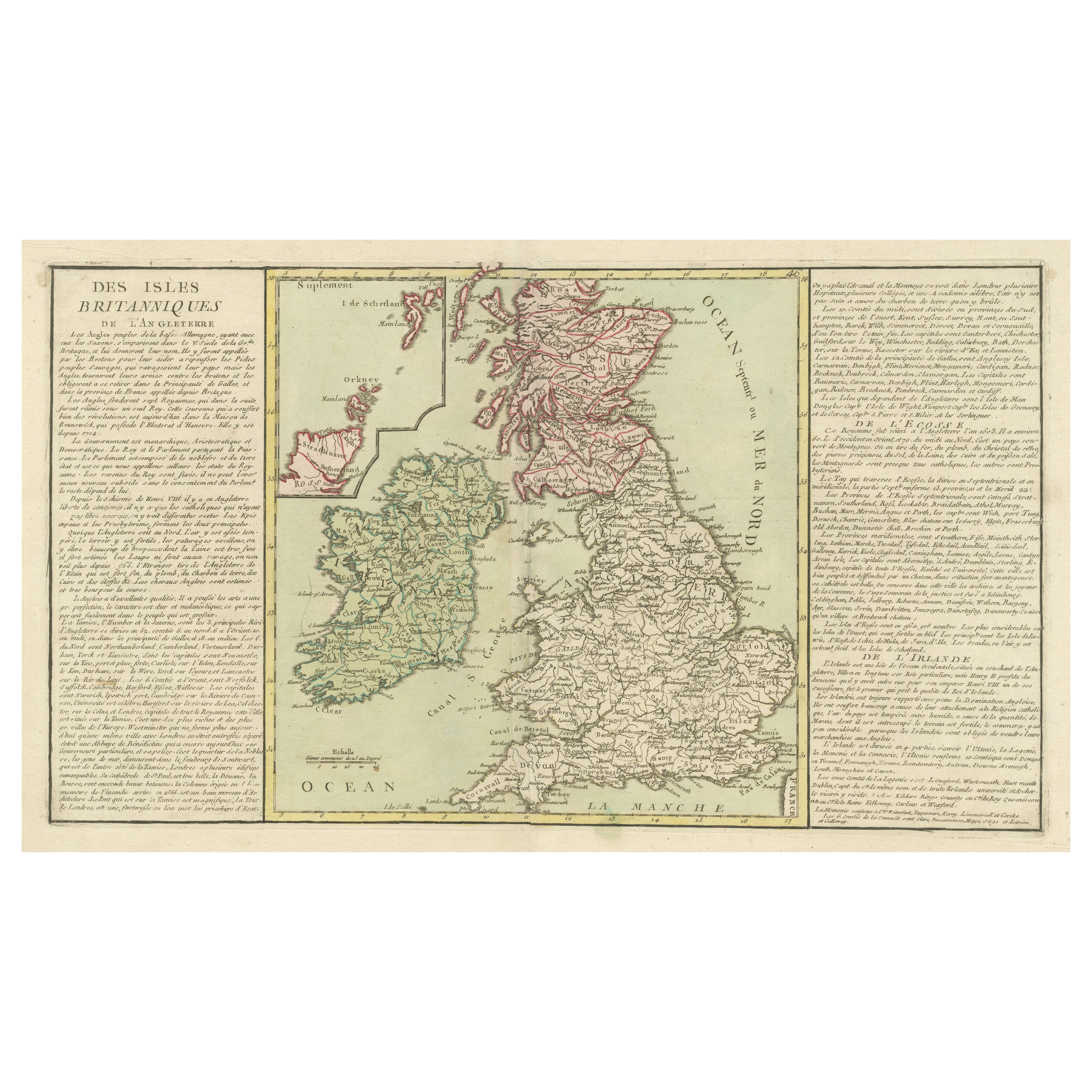
Antique map titled 'Des Isles Britanniques'. Original antique map of the British isles. This map is divided in to three major regions of the 18th century United Kingdom: England, Ire...
Category
Antique Late 18th Century Maps
Materials
Paper

$351 Sale Price
20% Off
Antique Map of the British Isles by Covens
Mortier, 1730
By Covens
Mortier
Located in Langweer, NL
Covens and Mortier's attractive double-page engraved map of the British Isles, based on the 1702 De L'Isle map. The map features a large car...
Category
Antique Mid-18th Century Maps
Materials
Paper

$617 Sale Price
20% Off
Antique Map of Great Britain and Ireland by Brion de la Tour, 1766
Located in Langweer, NL
Antique map titled 'Les Isles Britanniques (..).'
Attractive map of Great Britain surrounded by an engraved border printed from a separate coppe...
Category
Antique 18th Century Maps
Materials
Paper
Detailed Antique Map of Britain, Wales and the Coast of Ireland
Located in Langweer, NL
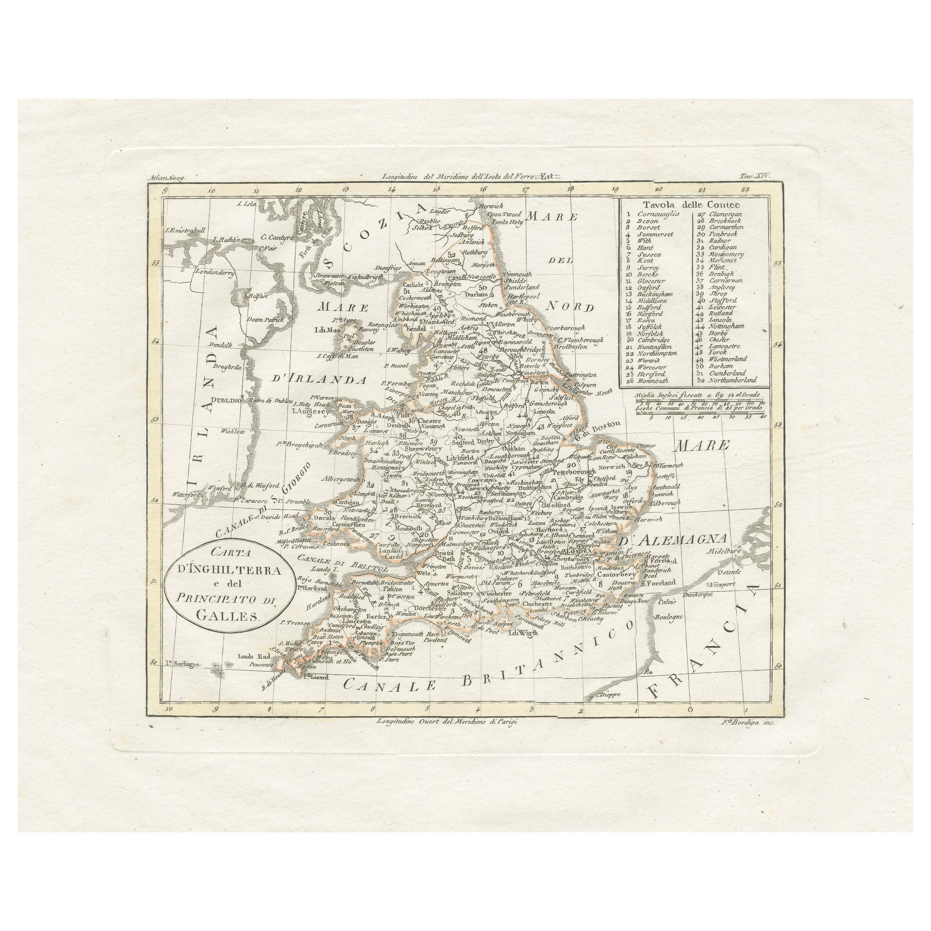
Antique map titled 'Carta d'Inghilterra e del Principato di Galles'. Detailed map of Britain, Wales and the coast of Ireland with a list of counties. This map originates from 'Nuovo ...
Category
Antique Mid-19th Century Maps
Materials
Paper

$246 Sale Price
20% Off
You May Also Like
England, Scotland
Ireland: A Hand Colored Map of Great Britain by Tirion
By Isaak Tirion
Located in Alamo, CA
This is a hand-colored double page copperplate map of Great Britain entitled "Nieuwe Kaart van de Eilanden van Groot Brittannien Behelzende de Kon...
Category
Antique Mid-18th Century Dutch Maps
Materials
Paper

England and the British Isles: A Large 17th Century Hand-colored Map by de Wit
By Frederick de Wit
Located in Alamo, CA
This is a large hand-colored 17th century map of England and the British Isles by Frederick de Wit entitled "Accuratissima Angliæ Regni et Walliæ Principatus", published in Amsterdam in 1680. It is a highly detailed map of England, Scotland, the Scottish Isles...
Category
Late 17th Century Other Art Style Landscape Prints
Materials
Engraving

Large 17th Century Hand Colored Map of England and the British Isles by de Wit
By Frederick de Wit
Located in Alamo, CA
A large hand colored 17th century map of England and the British Isles by Frederick de Wit entitled "Accuratissima Angliæ Regni et Walliæ Principatus", published in Amsterdam in 1680. It is a highly detailed map of England, Scotland, the Scottish Isles...
Category
Antique Late 17th Century Dutch Maps
Materials
Paper

Original Antique Map of Scotland by Dower, circa 1835
Located in St Annes, Lancashire
Nice map of Scotland
Drawn and engraved by J.Dower
Published by Orr & Smith. C.1835
Unframed.
Free shipping
Category
Antique 1830s English Maps
Materials
Paper

Antique Lithography Map, Oxfordshire, English, Framed Cartography, Robert Morden
Located in Hele, Devon, GB
This is an antique lithography map of Oxfordshire. An English, framed atlas engraving of cartographic interest by Robert Morden, dating to the late 17th century and later.
Superb l...
Category
Antique Late 17th Century British William and Mary Maps
Materials
Paper
Large Original Vintage Map of the United Kingdom, circa 1920
Located in St Annes, Lancashire
Great map of The United Kingdom
Unframed
Original color
By John Bartholomew and Co. Edinburgh Geographical Institute
Published, circa 1920
Free shipping.
Category
Vintage 1920s British Maps
Materials
Paper
