Items Similar to Caen – Antique Hand-Coloured Normandy Town Plan Engraving (1666)


Want more images or videos?
Request additional images or videos from the seller
1 of 9
Caen – Antique Hand-Coloured Normandy Town Plan Engraving (1666)
$455.98
£337.91
€380
CA$623.20
A$678.40
CHF 360.10
MX$8,162.61
NOK 4,562.89
SEK 4,180.90
DKK 2,894.57
About the Item
Caen – Antique Hand-Coloured Normandy Town Plan Engraving (1666)
This 17th-century copper engraving offers a finely detailed early plan of Caen, published in Antwerp in 1666 for the atlas associated with the Fransche Merkurius. Shown from an elevated bird’s-eye perspective, the engraving captures Caen’s historical centre with its fortified walls, winding streets, river network, bridges, gardens and surrounding agricultural lands. The engraving retains its period hand-colouring in harmonious shades of red, green and blue, enhancing the clarity of the town layout and giving the piece strong decorative character.
Small-format town plans from the Fransche Merkurius are sought after for their crisp, uncomplicated engraving style and their value as early visual records of French urban centres. Caen—one of the most important cities of Normandy—appears here in its 17th-century form, with the Abbaye-aux-Hommes, defensive structures and medieval street grid clearly represented. The wide margins, strong impression and attractive hand-colouring make this an appealing print for collectors of Normandy, French cartography and early urban history.
Condition report:
Good condition. Image area clean with bright and well-preserved hand-colouring. Noticeable foxing and toning in the blank margins, typical for 17th-century laid paper. No tears, losses or repairs affecting the printed image. Plate impression clear and well defined.
Framing tips:
A walnut, oak or light natural wood frame complements the green and red tones of the hand-colouring. A soft ivory or cream mat will reduce the visual impact of the marginal foxing and draw the eye into the central plan. For a contemporary interior, a thin black frame with a wide white mat provides a crisp, modern presentation.
Technique: Hand-coloured copper engraving
Maker: Published in Antwerp for Fransche Merkurius, 1666
- Dimensions:Height: 6.07 in (15.4 cm)Width: 8.63 in (21.9 cm)Depth: 0.01 in (0.2 mm)
- Materials and Techniques:Paper,Engraved
- Place of Origin:
- Period:1660-1669
- Date of Manufacture:1666
- Condition:Good condition. Image area clean with bright and well-preserved hand-colouring. Noticeable foxing and toning in the blank margins, typical for 17th-century laid paper. No tears, losses or repairs affecting the printed image. Plate impression clear.
- Seller Location:Langweer, NL
- Reference Number:Seller: BG-14168-41stDibs: LU3054347806792
About the Seller
5.0
Recognized Seller
These prestigious sellers are industry leaders and represent the highest echelon for item quality and design.
Platinum Seller
Premium sellers with a 4.7+ rating and 24-hour response times
Established in 2009
1stDibs seller since 2017
2,819 sales on 1stDibs
Typical response time: 1 hour
- ShippingRetrieving quote...Shipping from: Langweer, Netherlands
- Return Policy
More From This Seller
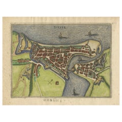
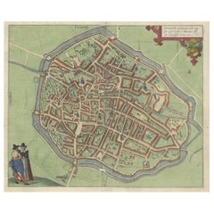
View AllDieppe – Antique Hand-Coloured French Coastal Town Engraving (1666)
Located in Langweer, NL
Dieppe – Antique Hand-Coloured French Coastal Town Engraving (1666)
This charming 17th-century copper engraving presents an early bird’s-eye plan of the fortified port town of Diepp...
Category
Antique 1660s Belgian Maps
Materials
Paper
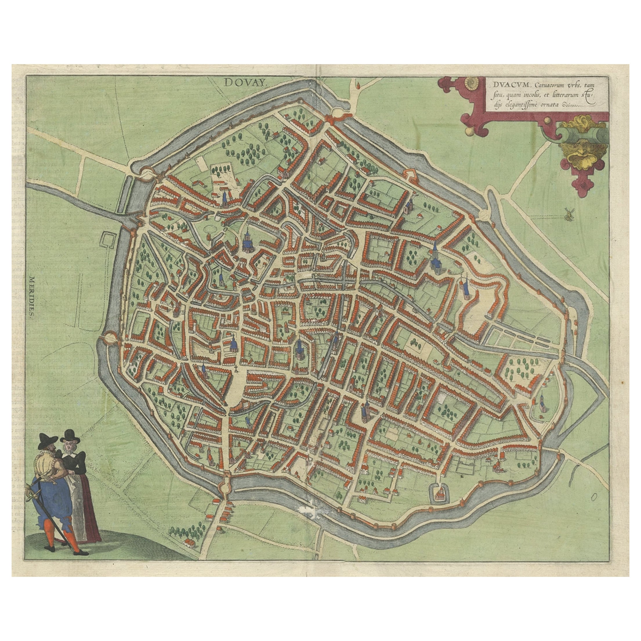
Very Old Original Antique Map of The City of Douai in France, ca.1575
Located in Langweer, NL
Antique Map of Douai (France) titled 'Duacum, Catuacorum Urbs, tam situ, quam incolis, et litterarum studijs elegantissime ornata'.
This map depicts the city of Douai (France) an...
Category
Antique 16th Century Maps
Materials
Paper
$787 Sale Price
20% Off
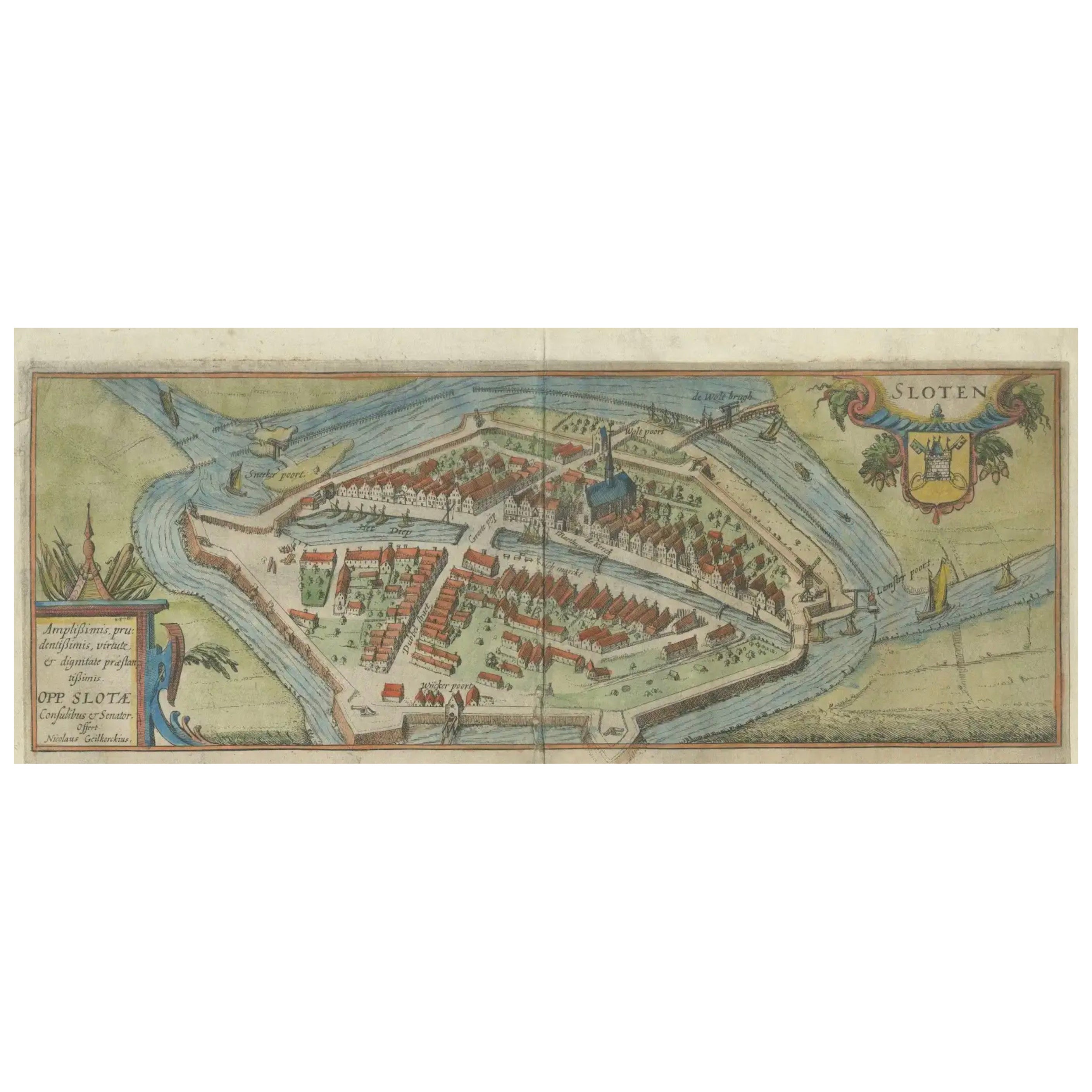
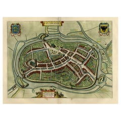
Dutch City Plan of Sloten in Friesland by N. Van Geelkercken, hand-colored 1616
Located in Langweer, NL
Bird’s-Eye View of Sloten in Friesland by Nicolaes van Geelkercken, ca. 1616
This captivating hand-colored engraving presents an early 17th-century bird’s-eye view of the fortified ...
Category
Antique 1610s Dutch Maps
Materials
Paper
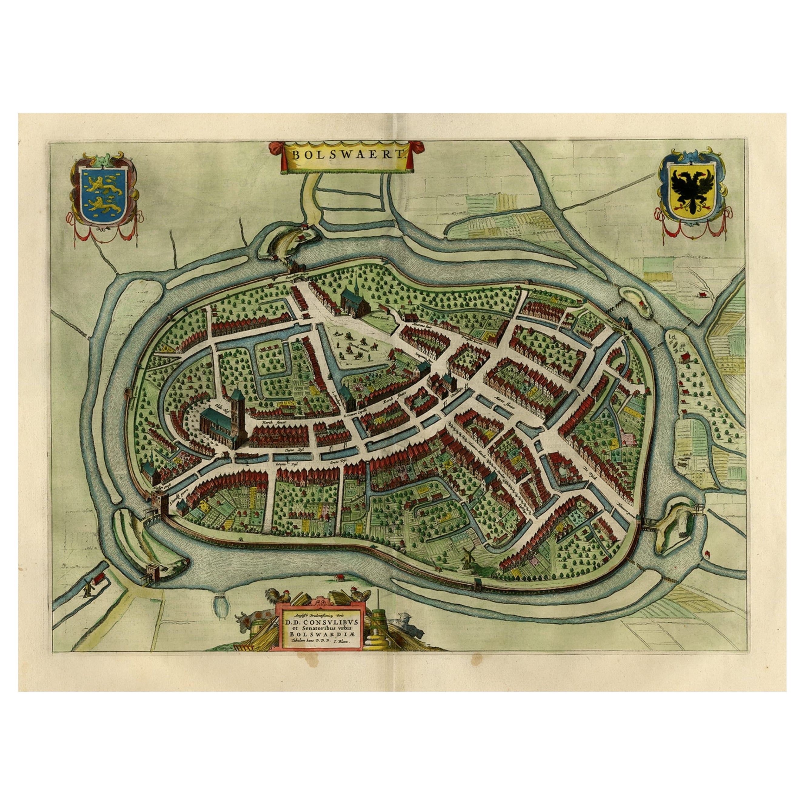
Nice Hand-Colored Plan by Blaeu of Bolsward in Friesland, the Netherlands, 1652
Located in Langweer, NL
Antique print, titled: 'Bolswaert' - (Town plan of Bolsward).
Plan of Bolsward in Friesland, the Netherlands. A cartouche and two coats of arms. From the town atlas 'Toneel der S...
Category
Antique 1650s Maps
Materials
Paper
$1,103 Sale Price
20% Off
Antique Map of Douai
France
by Braun
Hogenberg, circa 1575
Located in Langweer, NL
Beautiful map in excellent condition. This map depicts the city of Douai (France) and originates from 'Civitates Orbis Terrarum'.
Category
Antique 16th Century Maps
Materials
Paper

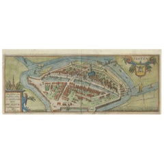
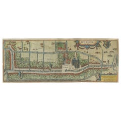
Dutch City Plan of Workum in Friesland by N. Van Geelkercken, hand-colored 1616
Located in Langweer, NL
Workum in Friesland by Nicolaes van Geelkercken, hand-colored map ca. 1616
This beautifully hand-colored engraving titled 'Worcum' presents an early 17th-century bird’s-eye view of ...
Category
Antique 1610s Dutch Maps
Materials
Paper
You May Also Like
Tournai (Tournay), Belgium: A 16th Century Hand-colored Map by Braun
Hogenberg
By Franz Hogenberg
Located in Alamo, CA
This is a 16th century original hand-colored copperplate engraved map of Tournai, Belgium, entitled "Tornacum" by Georg Braun & Franz Hogenberg, in volume IV of their famous city atlas "Civitates Orbis Terrarum", published in Cologne or Augsberg, Germany in 1575. The map provides a bird's-eye view of the walled city of Tournai, the second oldest city in Belgium. It lies approximately one hour by car southwest of Brussels or from Ghent. The names of thirty of its streets, prominent buildings, churches and squares are listed in a key within a strap-work cartouche in the lower left. These locations are numbered in the key corresponding to their locations on the map.
This colorful map of Tournai (Tornacum or Tournay as it was called in the 16th century) includes the title in Latin in a cartouche in the upper center. Three crests are present across the upper map. A man and two woman are standing on a hill in the foreground in the lower right dressed in the style of 16th century upper class residents of the town.
This is an English translation of an excerpt of Braun's description of Tornai: “Tornacum or Turnacum is a city in Gallia Belgica, situated on the Schelde in the territory of the Nervii, called Tournai by its French inhabitants, but Dorneck by the Germans. Tournai has always been a large and powerful city, with an abundance of goods and commercial activities and wonderfully resourceful craftsmen, who invent new articles every day, and although some of these go out of use they constantly conceive of other new things, both useful and delightful, so that they have at all times something that provides work and a means of livelihood for the poor."
ReferencesVan der Krogt 4, 4435, State 1; Taschen, Braun and Hogenberg...
Category
16th Century Old Masters Landscape Prints
Materials
Engraving

Utrecht, Netherlands: A Large 17th Century Hand-colored Map by Sanson
Jaillot
By Nicholas Sanson d
Abbeville
Located in Alamo, CA
This large hand-colored map entitled "La Seigneurie d'Utrecht. Dressé sur les memoires les plus nouveaux par le Sr. Sanson" was originally created by Nicholas Sanson d'Abbeville. Thi...
Category
1690s Landscape Prints
Materials
Engraving

The Loire Valley of France: A 17th C. Hand-colored Map by Sanson and Jaillot
By Nicholas Sanson d
Abbeville
Located in Alamo, CA
This large 17th century copper plate hand-colored engraved map entitled "Gouvernement D'Orleans et la Generalite divisee en ses Elections Par...
Category
1690s Landscape Prints
Materials
Engraving

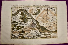
Vienna, Austria: A Large 17th Century Hand-colored Map by Sanson and Jaillot
By Nicholas Sanson d
Abbeville
Located in Alamo, CA
This large 17th century hand-colored map of Vienna, Austria and the surrounding countryside and villages entitled "Plan de la Ville de Vienne en Austrich...
Category
1690s Landscape Prints
Materials
Engraving
The Normandy Region of France: A 17th C. Hand-colored Map by Sanson and Jaillot
By Nicholas Sanson d
Abbeville
Located in Alamo, CA
This large hand-colored map entitled "Le Duché et Gouvernement de Normandie divisée en Haute et Basse Normandie en divers Pays; et par evêchez, avec le Gouvernement General du Havre ...
Category
1690s Landscape Prints
Materials
Engraving

18th Century Map Engraving - Newport, a Strong Sea-Port Town in Flanders
Located in Corsham, GB
A map of Nieuwpoort, anglicised to 'Newport', in northern Belgium. There is a panorama in the upper quarter depicting major landmarks. Below is a plan of the town, including its strong defences and ships at the port in the lower register. Inscribed with the title in plate to the lower edge, 'Newport a Strong Sea-Port Town...
Category
18th Century More Prints
Materials
Engraving

$269 Sale Price
20% Off