Items Similar to Canary Islands
Madeira Map – Atlantic Archipelagos c.1780


Want more images or videos?
Request additional images or videos from the seller
1 of 10
Canary Islands
Madeira Map – Atlantic Archipelagos c.1780
$384.61
£284.89
€320
CA$526.13
A$573.46
CHF 303.18
MX$6,903.31
NOK 3,848.12
SEK 3,527.94
DKK 2,438.22
About the Item
Canary Islands
Madeira Map – Atlantic Archipelagos c.1780
DESCRIPTION
This map focuses on the Canary Islands, Madeira, and Porto Santo, vital Atlantic staging points for European navigation. Engraved under Rigobert Bonne’s direction, it emphasizes precise coastal outlines and island placement rather than ornament. These islands played key roles in transatlantic voyages to Africa and the Americas. The map’s clarity and restrained style make it an excellent example of Enlightenment island cartography.
KEYWORDS
Canary Islands map, Madeira Porto Santo, Atlantic navigation, transatlantic routes, island cartography
CONDITION REPORT
Light age toning. Central fold. Minor edge wear and scattered foxing.
FRAMING TIPS
Float-mount recommended; light mat with slim dark frame for clean presentation.
Technique: Engraving
Maker: Rigobert Bonne, France, circa 1780
- Dimensions:Height: 16.15 in (41 cm)Width: 10.24 in (26 cm)Depth: 0.01 in (0.2 mm)
- Materials and Techniques:Paper,Engraved
- Place of Origin:
- Period:
- Date of Manufacture:Circa 1780
- Condition:Light age toning. Central fold as issued. Minor edge wear and scattered foxing.
- Seller Location:Langweer, NL
- Reference Number:Seller: BG-14105-91stDibs: LU3054348107912
About the Seller
5.0
Recognized Seller
These prestigious sellers are industry leaders and represent the highest echelon for item quality and design.
Platinum Seller
Premium sellers with a 4.7+ rating and 24-hour response times
Established in 2009
1stDibs seller since 2017
2,813 sales on 1stDibs
Typical response time: 1 hour
- ShippingRetrieving quote...Shipping from: Langweer, Netherlands
- Return Policy
More From This Seller
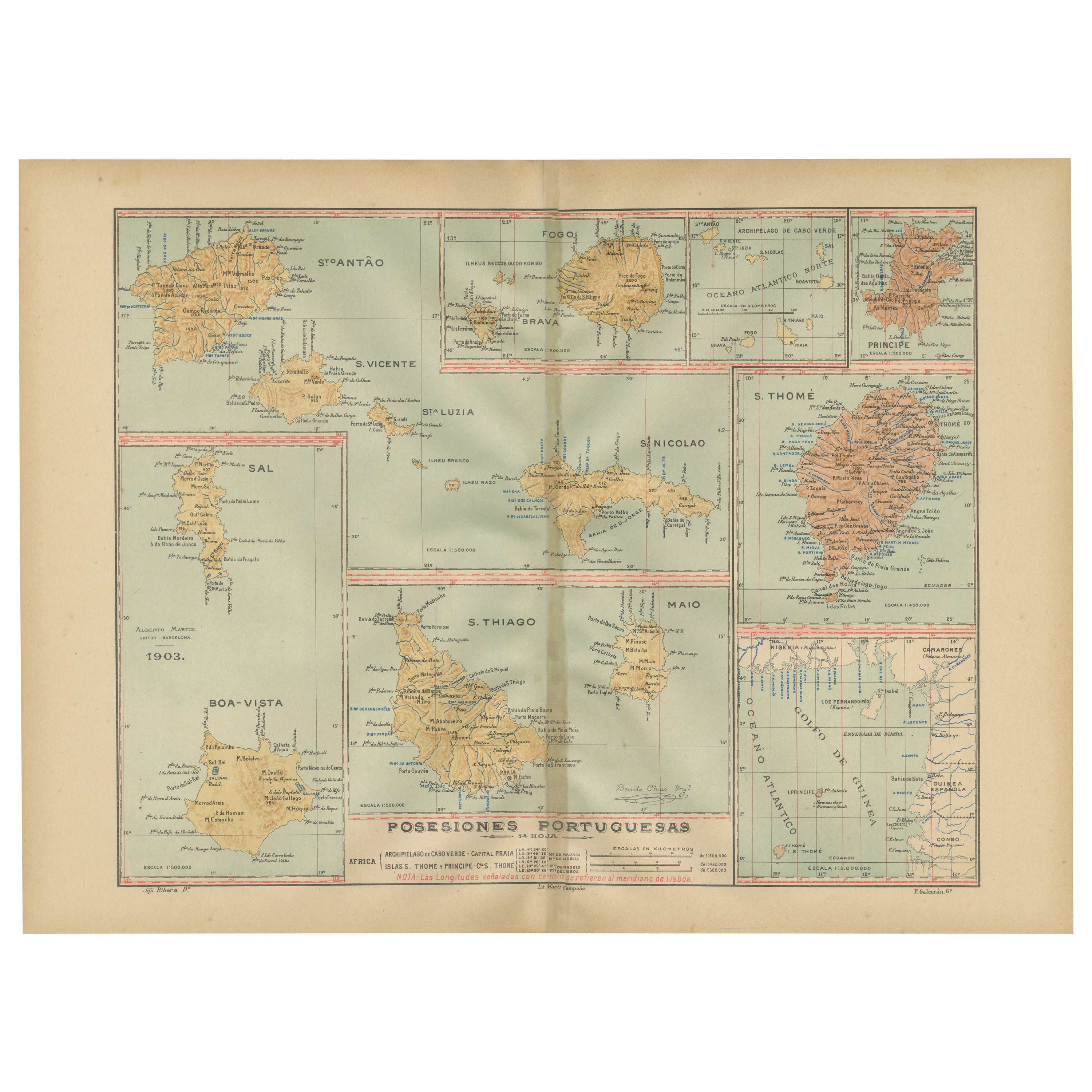
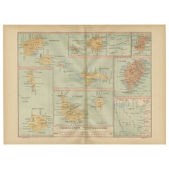
View AllIslands of Diversity: Portugal
s Atlantic Archipelagos in 1903
Located in Langweer, NL
The image is an original historical map from 1903 depicting Portuguese possessions in the Atlantic Ocean, specifically the islands of Cape Verde and the islands of São Tomé and Prínc...
Category
Antique Early 1900s Maps
Materials
Paper
Old Map of Morocco, The Canary Islands, Madeira, Inset of Penon de Velez, 1605
Located in Langweer, NL
Antique map titled 'Fessae et Marocchi Regna'. Original antique map of Morocco, extending south to Cape Bojador and , north to the Spanish Coast. Inset of Penon de Velez. Artists and...
Category
Antique 17th Century Dutch Maps
Materials
Paper
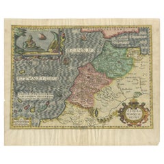
$1,126 Sale Price
25% Off
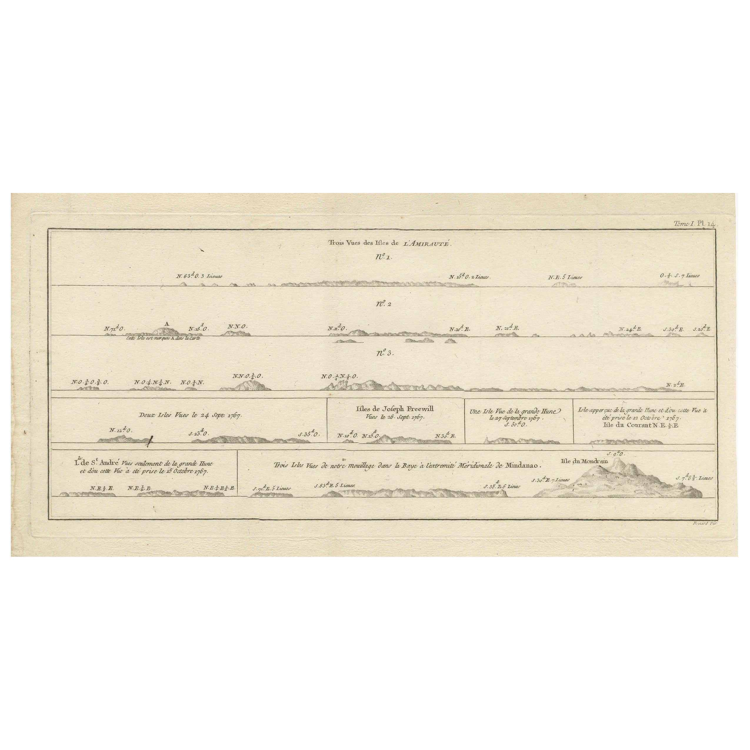
Antique Map of the Admiralty Islands, Bismarck Archipelago
Located in Langweer, NL
Antique map titled 'Trois Vues des Isles de l'Amirauté'. Several coastal views of the Admiralty Islands, Bismarck Archipelago, to the north of New Guinea in the South Pacific Ocean.
...
Category
Antique Late 18th Century Maps
Materials
Paper
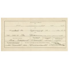
$365 Sale Price
20% Off
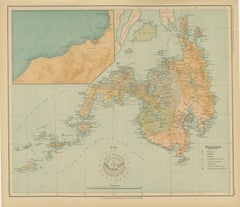
Antique Map of the Atlantic Islands, 1817
Located in Langweer, NL
Antique map titled 'Atlantic Islands'. Large map of the Atlantic Islands include the Cape Verde islands, Canary islands, Azore islands and Madeira islands. Also included a view of th...
Category
Antique Early 19th Century Maps
Materials
Paper

$432 Sale Price
20% Off
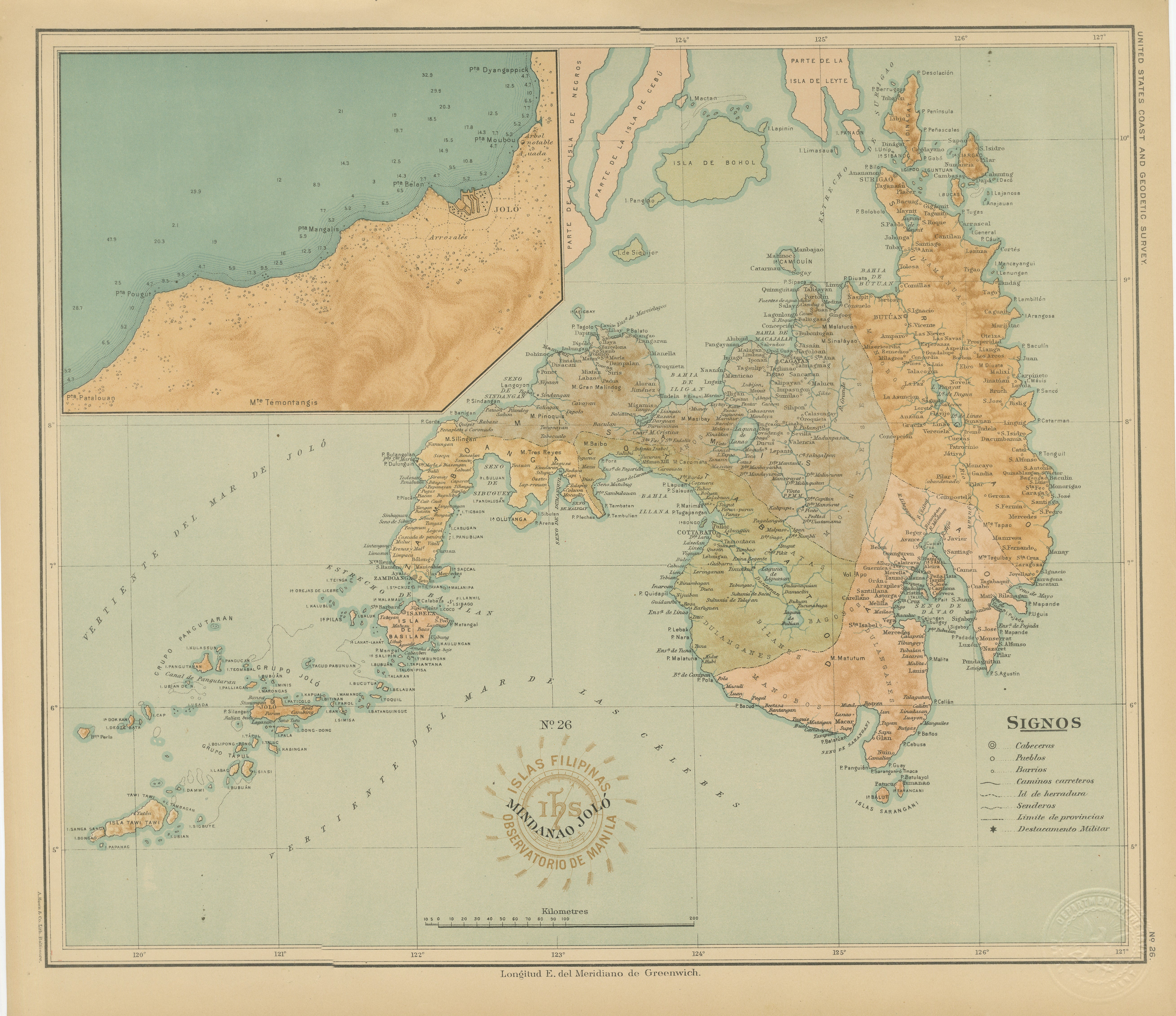
Map of the Island of Mindanao and the Sulu Archipelago – 1899
Located in Langweer, NL
Map of Batanes and Babuyan Islands – *Observatorio de Manila*, 1899
An original late-19th-century scientific map of the Batanes and Babuyan island groups, situated north of Luzon, p...
Category
Antique 1890s Philippine Maps
Materials
Paper
1855 Colton
s Map of Patagonia with South Atlantic Islands Insets
Located in Langweer, NL
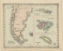
Title: 1855 Colton's Map of Patagonia with South Atlantic Islands Insets
Description: This is an 1855 map titled "Colton's Patagonia," published by J.H. Colton & Co. in New York. Th...
Category
Antique 1850s Maps
Materials
Paper
$192 Sale Price
42% Off
You May Also Like
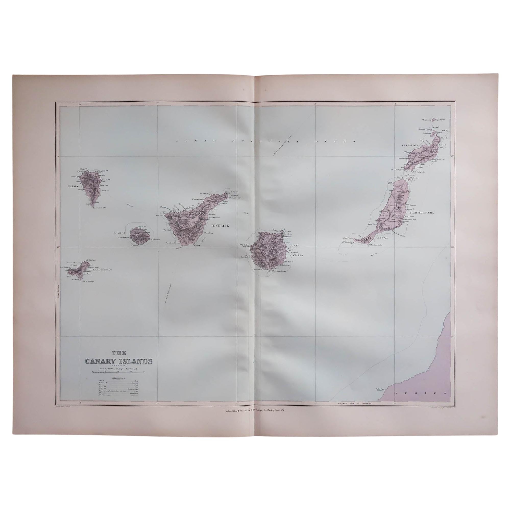
Large Original Antique Map of The Canary Islands. 1894
Located in St Annes, Lancashire
Superb Antique map of The Canary Islands
Published Edward Stanford, Charing Cross, London 1894
Original colour
Good condition
Unframed.
Free shipping
Category
Antique 1890s English Maps
Materials
Paper

1865 Chart of the Islands of Madeira
Located in Norwell, MA
Rare James Imray chart from 1865 titled "Chart of the Islands of Madeira, Porto Santo and Dezerea" drawn from the survey made by Captain Ate Vidal Royal Navy, London. Published by Ja...
Category
Antique 1860s European Maps
Materials
Paper

Large Original Antique Map of Madeira. 1894
Located in St Annes, Lancashire
Superb Antique map of Madeira
Published Edward Stanford, Charing Cross, London 1894
Original colour
Good condition
Unframed.
Free shipping
Category
Antique 1890s English Maps
Materials
Paper

Original Antique Map of South America. C.1780
Located in St Annes, Lancashire
Great map of South America
Copper-plate engraving
Published C.1780
Two small worm holes to left side of map
Unframed.
Category
Antique Early 1800s English Georgian Maps
Materials
Paper

Map Jersey Guernsey Scilly Islands Alderney
Located in BUNGAY, SUFFOLK
Rare map of The Islands of Guernsey and Jersey, including Alderney & the Scilly Islands
just purchased more information to follow
In the original cream mount and gilded frame.
Category
Antique 18th Century English Georgian Maps
Materials
Paper

1854 Map of Massachusetts, Connecticut and Rhode Island, Antique Wall Map
Located in Colorado Springs, CO
This striking wall map was published in 1854 by Ensign, Bridgman & Fanning and has both full original hand-coloring and original hardware. This impression is both informative and highly decorative.
The states are divided into counties, outlined in red, green, and black, and subdivided into towns. Roads, canals, and railroad lines are prominently depicted, although they are not all labeled. The mapmakers also marked lighthouses, banks, churches, and prominent buildings, with a key at right. The map is an informative and comprehensive overview of the infrastructural development of New England prior to the Civil War. Physical geographies depicted include elevation, conveyed with hachure marks, rivers and lakes. The impression features an inset map of Boston...
Category
Antique 19th Century American Maps
Materials
Paper
