Items Similar to Cape of Good Hope – Fort and City Plan, French Colonial Map, c.1765

Want more images or videos?
Request additional images or videos from the seller
1 of 9
Cape of Good Hope – Fort and City Plan, French Colonial Map, c.1765
$684.61
£507.58
€570
CA$940.49
A$1,026.70
CHF 540.57
MX$12,298.68
NOK 6,913.70
SEK 6,312.32
DKK 4,343.19
About the Item
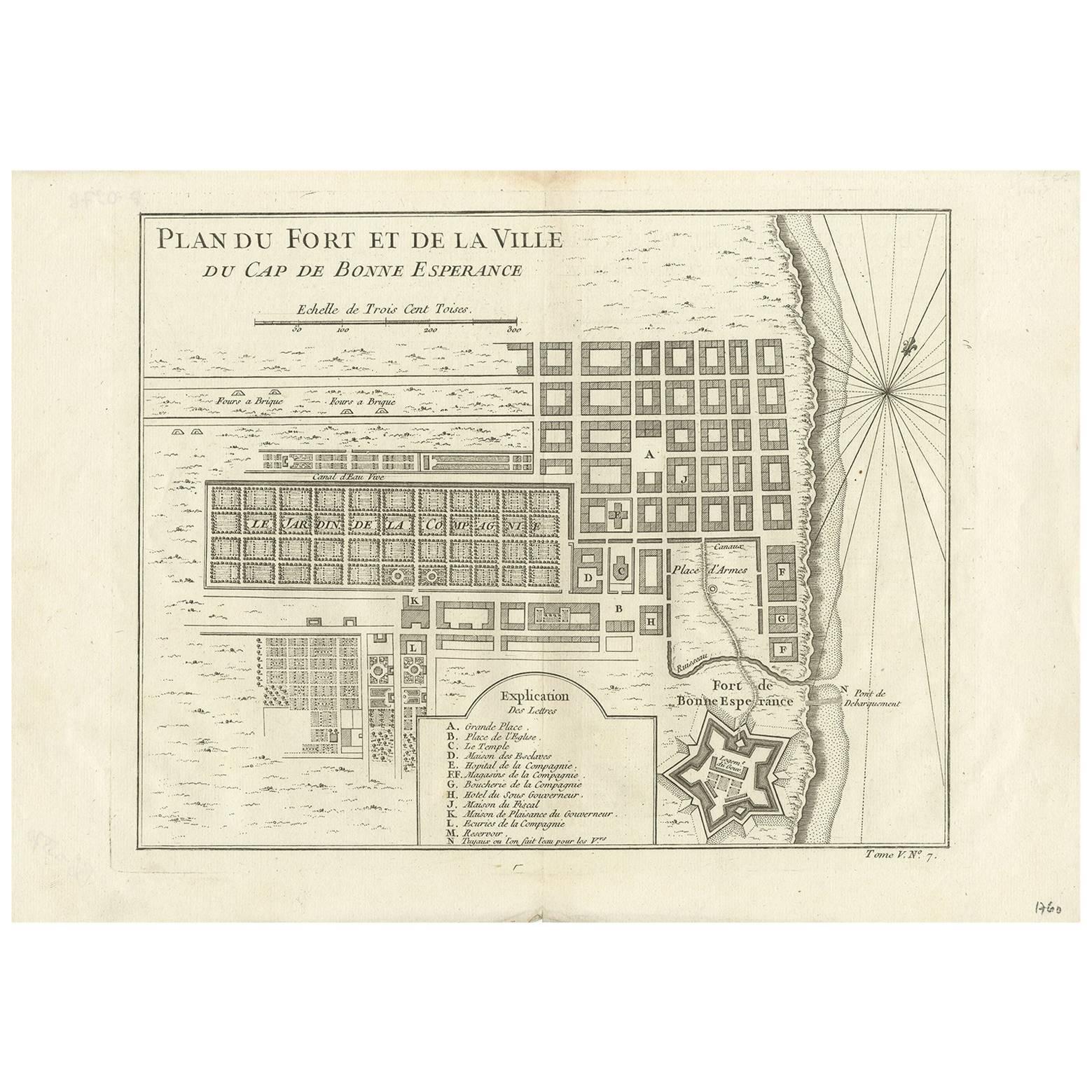
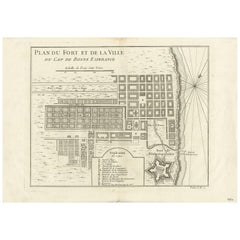
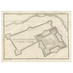
Cape of Good Hope – Fort and City Plan, French Colonial Map, c.1765
This detailed French plan depicts the fortifications and urban layout of the Cape of Good Hope, one of the most strategically important colonial ports of the 18th century. Titled “Plan du Fort et de la Ville du Cap de Bonne Esperance,” the map was engraved under the direction of Jacques-Nicolas Bellin, Hydrographer to the French King, and published in Paris circa 1760–1770 as part of his official hydrographic work for the Dépôt des cartes et plans de la Marine.
The plan shows the Cape as a carefully organized colonial settlement, with its rectilinear street grid, public squares, gardens, canals, and key administrative buildings clearly delineated. The famous star-shaped Fort de Bonne Esperance is rendered in precise detail, reflecting contemporary military engineering principles and the defensive importance of the site for European powers navigating between the Atlantic and Indian Oceans.
Bellin’s plan combines urban cartography with maritime intelligence. The shoreline, anchorage, landing points, and compass rose emphasize the Cape’s role as a critical resupply and control point on global trade routes linking Europe, Africa, and Asia. The inclusion of an explanatory legend identifying principal buildings and functions underscores the map’s practical and administrative purpose.
Although the Cape was under Dutch control at the time, French naval and commercial interests made accurate knowledge of the settlement essential. Bellin’s work reflects the broader European competition for influence along African coasts and sea routes during the mid-18th century. The restrained hand coloring, clear engraving, and balanced composition make this both a historically important document and a visually compelling display piece.
This plan is especially appealing to collectors of colonial urban history, fortification plans, and South African cartography, and it serves as an ideal counterpart to broader regional maps of East and Southern Africa.
Condition report
Good condition overall. Central vertical fold as issued. Light age toning consistent with period. Minor scattered spots and light surface marks. Original hand coloring. Plate mark visible. Margins intact.
Framing tips
A generous off-white or light sand-colored mat highlights the crisp geometry of the city grid and fort. A medium to dark wood frame complements the hand coloring and gives the piece a refined, architectural presence. Particularly effective as a focal work or paired with regional African maps.
Technique: Copper engraving with contemporary hand color
Maker: Jacques-Nicolas Bellin, France, c.1765
- Dimensions:Height: 10.04 in (25.5 cm)Width: 15.63 in (39.7 cm)Depth: 0.01 in (0.2 mm)
- Materials and Techniques:Paper,Engraved
- Place of Origin:
- Period:1760-1769
- Date of Manufacture:circa 1765
- Condition:Good condition overall. Central vertical fold as issued. Light age toning consistent with period. Minor scattered spots and light surface marks. Original hand coloring. Plate mark visible. Margins intact.
- Seller Location:Langweer, NL
- Reference Number:Seller: BG-14128-51stDibs: LU3054348016892
About the Seller
5.0
Recognized Seller
These prestigious sellers are industry leaders and represent the highest echelon for item quality and design.
Platinum Seller
Premium sellers with a 4.7+ rating and 24-hour response times
Established in 2009
1stDibs seller since 2017
2,810 sales on 1stDibs
Typical response time: <1 hour
- ShippingRetrieving quote...Shipping from: Langweer, Netherlands
- Return Policy
More From This Seller
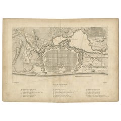
View AllAntique Map of the Cape of Good Hope by J.N. Bellin, 1748
Located in Langweer, NL
Early plan of the Cape of Good Hope, includng a town plan and illustrations of the fortificatons. This map originates from Tome V of Abbe Prevost's Histoire generale du voyages.
Category
Antique Mid-18th Century Maps
Materials
Paper
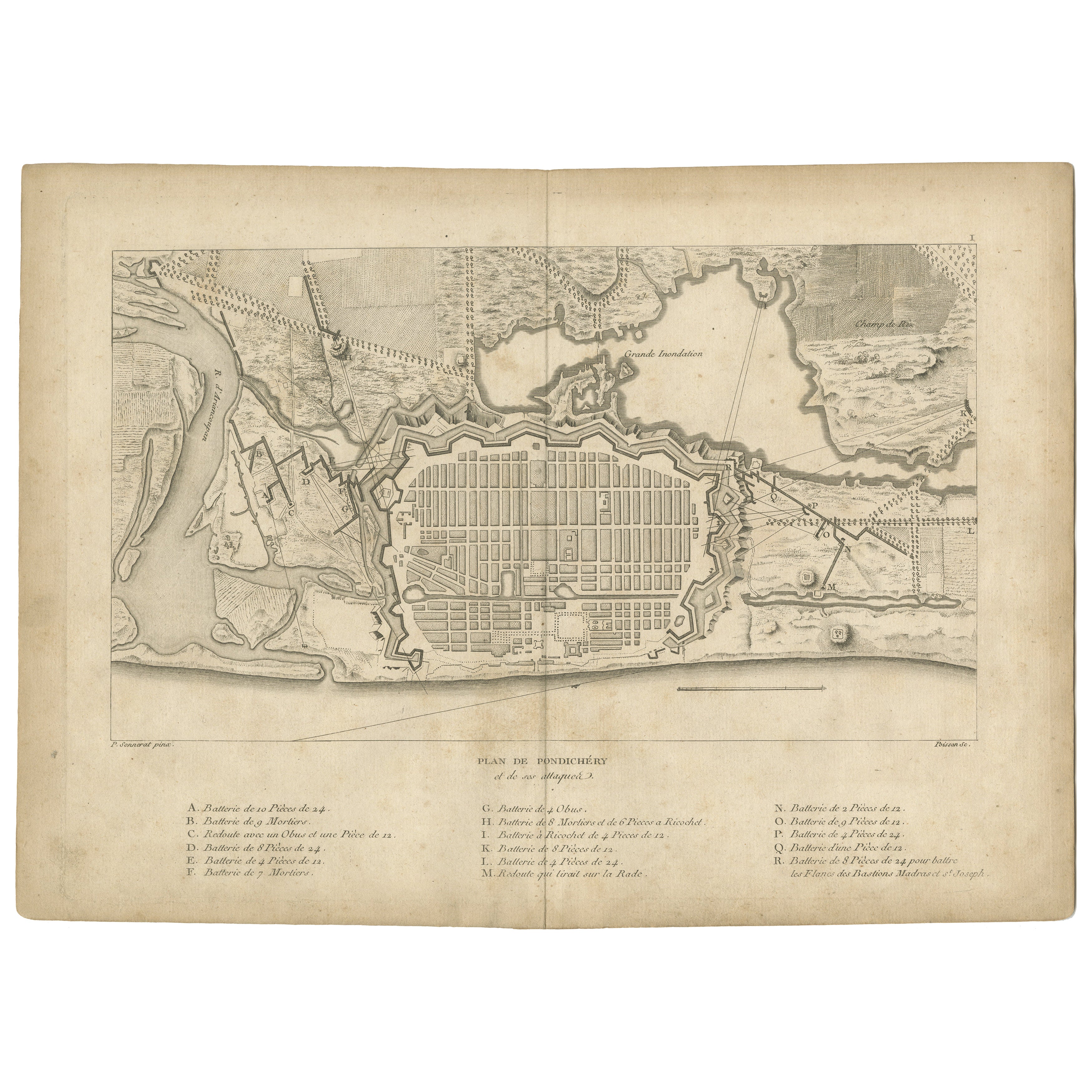
Plan of Pondicherry Fortifications and Attacks, France, c.1750
Located in Langweer, NL
Plan of Pondicherry Fortifications and Attacks, France, c.1750
This finely engraved map depicts the fortified city of Pondicherry, titled "Plan de Pondichéry et de ses attaques." It...
Category
Antique Mid-18th Century French Maps
Materials
Paper
Antique Map of the Environs of Cap-Français, Saint-Domingue, c.1760
Located in Langweer, NL
Antique Map of the Environs of Cap-Français, Saint-Domingue, c.1760
This detailed 18th-century copperplate engraving, titled Carte des Environs du Cap Français et des Paroisses qui ...
Category
Antique Early 18th Century French Maps
Materials
Paper
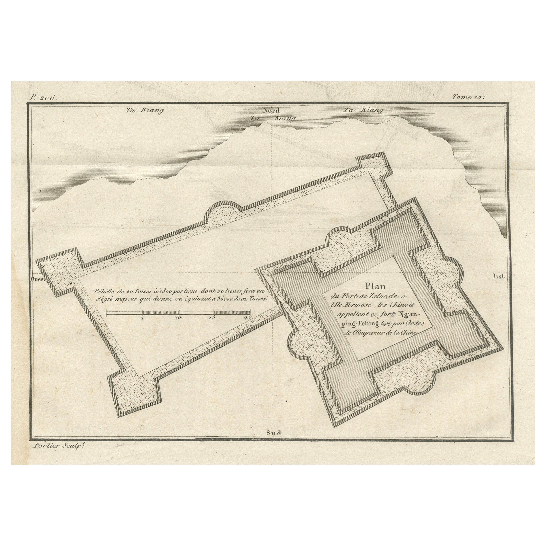
Plan of the Dutch Fort in Formosa – Antique French Jesuit Engraving, ca.1790
Located in Langweer, NL
Plan of the Dutch Fort in Formosa – Antique French Jesuit Engraving by Portier, c.1790
This antique French engraving by Portier, produced around 1790, shows a detailed plan of the D...
Category
Antique Late 18th Century French Maps
Materials
Paper
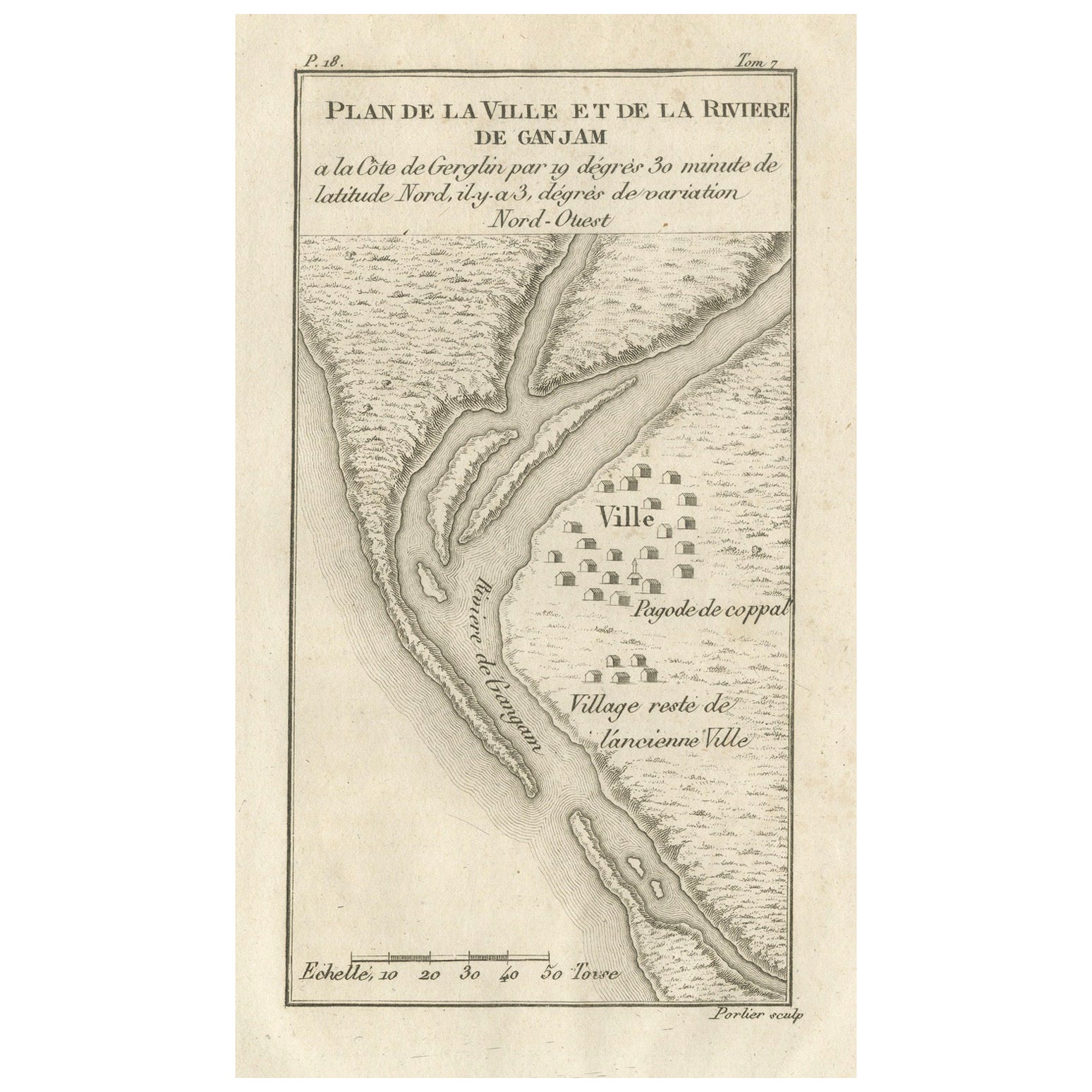
Plan of the Town and River of Ganjam, India – Antique French Map by Portier 1790
Located in Langweer, NL
Plan of the Town and River of Ganjam, India – Antique French Map by Portier, c.1790
This antique French engraving shows a detailed plan of the town and river of Ganjam, located on t...
Category
Antique Late 18th Century French Maps
Materials
Paper
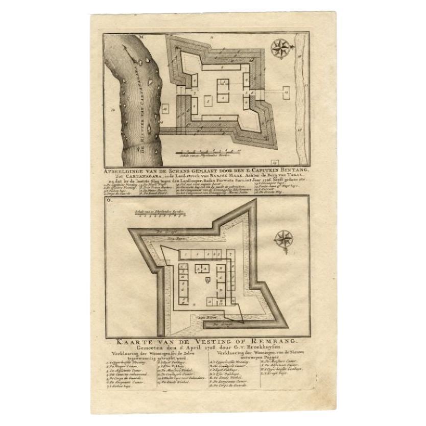
Antique Map of the Fortress of Captain E. Bintang by Valentijn, 1726
Located in Langweer, NL
Antique print titled 'Kaarte van de Schans gemaakt door den E. Capitein Bintang. Kaarte van de Vesting op Rembang.' A plan of the fort constructed by the Captain E. Bintang, in the B...
Category
Antique 18th Century Maps
Materials
Paper
You May Also Like
Original Antique Map or City Plan of Geneva, Switzerland. Circa 1835
Located in St Annes, Lancashire
Nice map of Geneva
Drawn and engraved by J.Dower
Published by Orr & Smith. C.1835
Unframed.
Free shipping
Category
Antique 1830s English Maps
Materials
Paper

18th Century Map Engraving - Plan of the Works of the City of Messina, Sicily
Located in Corsham, GB
A map of Messina, a harbour city in northeast Sicily. Inscribed with the title in plate to the lower edge, 'Plan of the Works of the City of Messina, one of the strongest and most co...
Category
18th Century More Prints
Materials
Engraving

$285 Sale Price
20% Off
18th Century Map Engraving - Newport, a Strong Sea-Port Town in Flanders
Located in Corsham, GB
A map of Nieuwpoort, anglicised to 'Newport', in northern Belgium. There is a panorama in the upper quarter depicting major landmarks. Below is a plan of the town, including its strong defences and ships at the port in the lower register. Inscribed with the title in plate to the lower edge, 'Newport a Strong Sea-Port Town...
Category
18th Century More Prints
Materials
Engraving

$269 Sale Price
20% Off
Plan of Port Siagi - Etching by Joseph Roux - 1795
Located in Roma, IT
Plan of Port Siagi is al colored etching realized by Joseph Roux in 1795.
The title at the top " Plan du Port Siagi"
Passepartout included: 34 x 49
The artwork is hand water-color...
Category
1790s Modern Figurative Prints
Materials
Etching

Antique 1765 Wine Country Folding Map of France, Bordeau etc.
Located in Paonia, CO
Route du Carosse de Bordeaux, part de Paris tous les Mardis a 11 matin. a et pafse 1765 is a comprehensive map with two routes through the wine country of France starting in Paris going south...
Category
1760s Other Art Style Landscape Prints
Materials
Etching

Cadiz Island: A Framed 17th Century Hand-colored Map from Blaeu
s Atlas Major
By Joan (Johannes) Blaeu
Located in Alamo, CA
This is a 17th century hand-colored map entitled "Insula Gaditana Isla de Cadiz" from Johannes (Joan) Blaeu's Atlas Maior, published in Amsterdam in 1662.
The map provides an excellent plan of Cadiz Island on the southwest coast of Spain, with its harbor, fortifications, agricultural fields and several surrounding salt processing areas. Numerous sailing ships of various sizes are included in and around the harbor and bay, including five large sailing ships, as well as twenty-four smaller ships. There is a small compass rose overlying the bay. The bridge to the mainland from the island is shown on the right. There is an extremely ornate and colorful title cartouche in the lower left, with its mythological figures reminiscent of Raphael’s Galatea fresco at the Villa Farnesina in Rome. The vibrant colors are vividly preserved. The master colorist tried to emulate a painting by using various tones to create a three-dimensional effect.
Blaeu's name is present in the plate in the lower right. Blaeu stated in his description of Cadiz: “The main wealth of the islanders consists of salt, which they harvest, and
the tuna fisheries.”
This 17th century hand-colored map is framed in an ornate, partially textured bronze-colored wood frame and glazed with UV protected conservation glass. There is a vertical center fold, as issued. There is a faint crease in the lower right and faint color offset on the left from the right side of the map, resulting from having been in an atlas for hundreds of years. Small foci of paint are present in the upper portion of the left margin and in the left corner margin. The map is otherwise in very good condition.
Due in large part to their powerful trade empire, the Dutch became known for cartography in the seventeenth century. This period is considered the Golden Age of Dutch cartography. Their publishing houses produced the highest quality work in Europe, particularly those maps and charts of foreign lands, and Dutch map-making set the bar for cartographic accuracy and artistry into the early-eighteenth century. Some of the most well-known cartographers worked in Amsterdam during this period. Perhaps the most famous of these was the Blaeu family. Willem Janszoon Blaeu, set up shop in Amsterdam. His son, Johannes (Joan), succeeded him upon his death in 1638, continuing in his father’s position as Hydrographer to the Dutch East India Company and selling maps to the public. The Blaeu map presses, located near Amsterdam’s Dam Square...
Category
Mid-17th Century Old Masters Landscape Prints
Materials
Engraving
