Items Similar to Cartographic Elegance: The Art and Science of 17th-Century Asian Maps, ca.1681


Want more images or videos?
Request additional images or videos from the seller
1 of 9
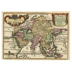
Cartographic Elegance: The Art and Science of 17th-Century Asian Maps, ca.1681
$370.21
$462.7620% Off
£276.38
£345.4720% Off
€312
€39020% Off
CA$514.33
CA$642.9120% Off
A$553.23
A$691.5420% Off
CHF 295.66
CHF 369.5820% Off
MX$6,521.04
MX$8,151.3020% Off
NOK 3,727.63
NOK 4,659.5320% Off
SEK 3,407.76
SEK 4,259.7020% Off
DKK 2,377.79
DKK 2,972.2420% Off
About the Item
This original antique map is an artifact from a pivotal era in cartography, reflecting not only the geographical knowledge of its time but also the intertwining of art and science in map-making.
The description indicates that it is an original colored copperplate print, which was a common technique used in the 17th century for producing maps. The copperplate engraving process involves etching or engraving the map onto a copper plate, which is then used to print the image onto paper. The addition of color was often done by hand, making each colored map from this period unique.
As for the cartographer, J. Harrewijn (also known as Jacques Harrewijn), he was an artist and engraver from the Low Countries, working around the late 17th century. While not as widely known as some of his contemporaries, Harrewijn contributed to the craft of mapmaking during a time often referred to as the "Golden Age of Cartography." This period was characterized by significant advancements in navigational techniques and a growing European interest in global exploration and trade. It was common during this era for cartographers to integrate current knowledge from explorers and scholars with decorative elements that made the maps not only informative but also visually appealing.
In terms of historical context, the map captures a time when the understanding of Asia's geography was evolving rapidly due to increased exploration and trade. The map's detail and artistic style provide insight into how Europeans of the time perceived the vast and diverse continent of Asia. The historical significance of such a map is profound, as it represents a bridge between ancient knowledge and the modern understanding of the world.
Asia's history, as mentioned, is vast and complex, with the development of civilizations across its various regions. It's important to recognize that while maps from this period attempted to be accurate, they were often influenced by the cartographer's limited knowledge and the geopolitical agendas of their patrons.
Given Harrewijn's contributions as a cartographer, his works would be of interest to historians, geographers, and collectors of antique maps. His engravings, like this map of Asia, serve as historical records that tell us about the state of geographical knowledge, as well as the artistry involved in the map-making process of his time.
- Dimensions:Height: 7.49 in (19 cm)Width: 9.22 in (23.4 cm)Depth: 0 in (0.02 mm)
- Materials and Techniques:Paper,Engraved
- Period:1680-1689
- Date of Manufacture:circa 1681
- Condition:Condition: good, given age. General age-related toning and/or occasional minor defects from handling. Please study scan carefully.
- Seller Location:Langweer, NL
- Reference Number:Seller: BG-137201stDibs: LU3054338597142
About the Seller
5.0
Recognized Seller
These prestigious sellers are industry leaders and represent the highest echelon for item quality and design.
Platinum Seller
Premium sellers with a 4.7+ rating and 24-hour response times
Established in 2009
1stDibs seller since 2017
2,836 sales on 1stDibs
Typical response time: 1 hour
- ShippingRetrieving quote...Shipping from: Langweer, Netherlands
- Return Policy
More From This Seller
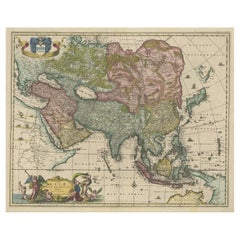
View AllAntique Duval Map of East Asia with China, Japan, Korea and the Great Wall, 1663
Located in Langweer, NL
Duval Asia Map 1663 China Japan Korea Great Wall Antique French Cartography
This elegant 17th-century map titled “L’Asie” is a finely executed French representation of the Asian continent by Pierre Duval, one of the foremost cartographers of Louis XIV’s France. Published in Paris in 1663, the map reflects a significant stage in European geographic knowledge, presenting Asia with increasing accuracy at a moment when global exploration, trade, and diplomatic contact were rapidly transforming Western understanding of the East.
Most of the place names shown represent geographical entities that still exist today or once existed historically, giving the map strong continuity between early modern geography and the modern world. Particularly notable is the improved rendering of Japan and the Korean peninsula, both shown with greater accuracy than in earlier 16th-century maps. The lower islands of Japan are better proportioned, and Korea is clearly depicted as a peninsula rather than an island, marking an important correction in European cartography.
China dominates the interior of the continent and is richly detailed with provinces, river systems, and cities. One of the most appealing features is the visible tracing of the Great Wall of China...
Category
Antique Mid-17th Century French Maps
Materials
Paper
Antique Map of Asia by Tirion
c.1760
Located in Langweer, NL
Antique map titled 'Nuova Carta dell Asia'. Decorative map of Asia. Published by I. Tirion, circa 1760.
Category
Antique Mid-18th Century Maps
Materials
Paper

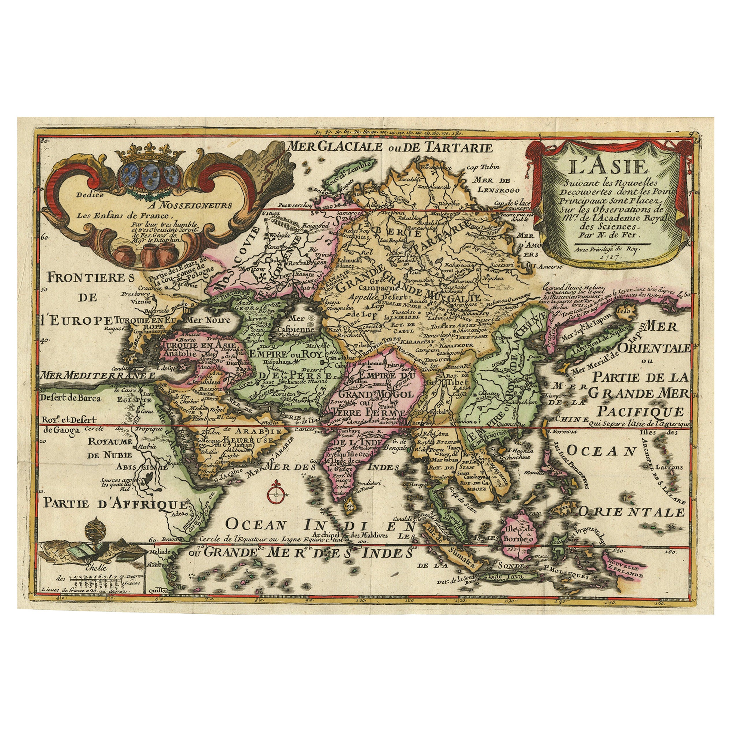
Rare Unusual Antique Map of Asia with a Landbridge from Korea to America, 1717
Located in Langweer, NL
Antique map titled 'L'Asie Suivant les Nouvelles Decouvertes (..).' Interesting and very unusual map of the Asian continent.
The map is based primarily on Dutch sources, particular...
Category
Antique 18th Century French Maps
Materials
Paper
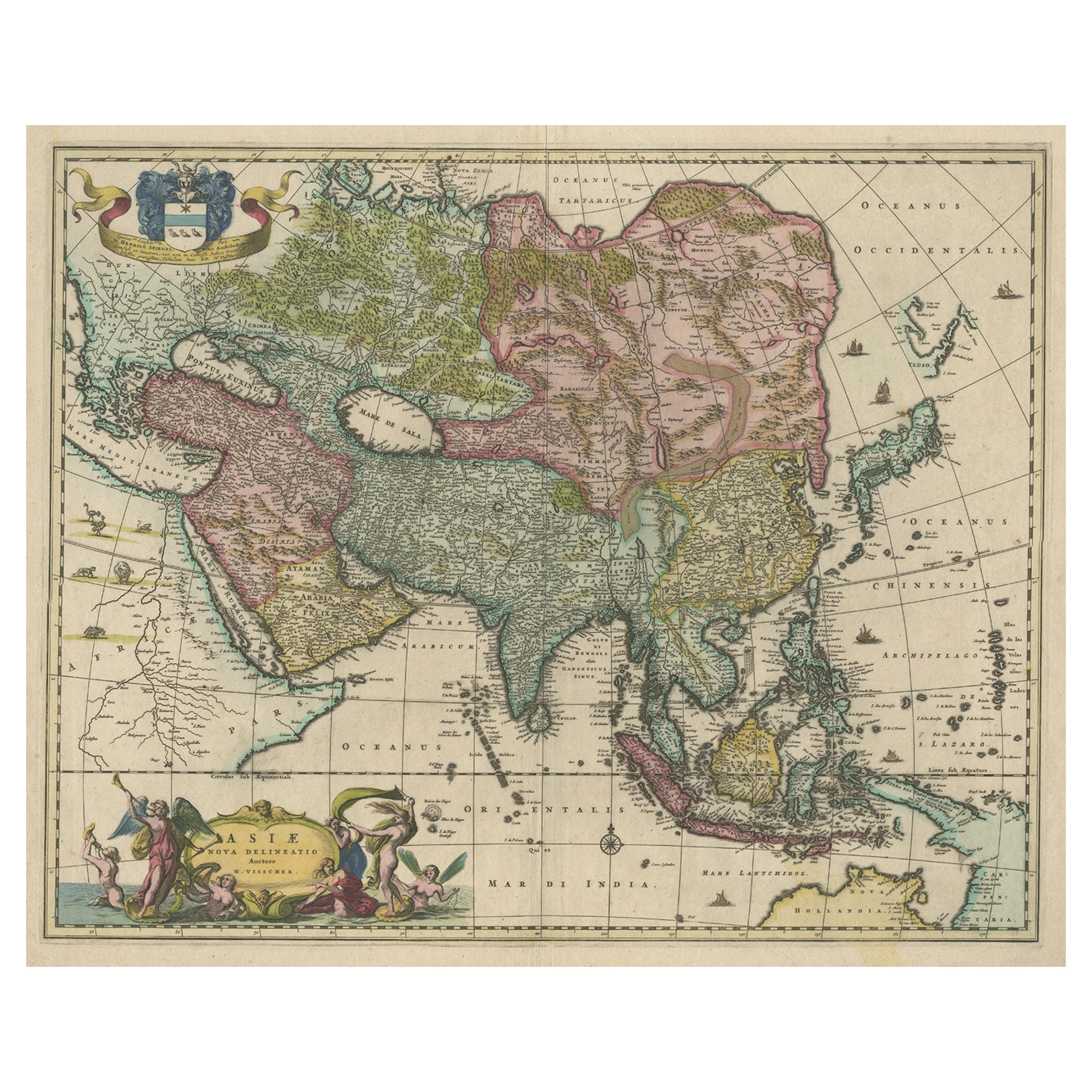
Antique Map of Asia and the East Indies and Korea as a Peninsula, ca.1660
Located in Langweer, NL
Antique map titled 'Asiae nova delineatio'. Decorative map of Asia and the East Indies. The map shows Korea as a peninsula. In China the Great Wall is depicted, as well as a long str...
Category
Antique 17th Century Maps
Materials
Paper
$2,373 Sale Price
20% Off
Free Shipping
Large Antique Map of Asia including All of Southeast Asia, c.1792
Located in Langweer, NL
Antique map titled 'L' Asie Divisee en ses Empires, Royaumes, et Etats'. Attractive, large map of Asia including all of Southeast Asia. The cartography is archaic for the period with...
Category
Antique 18th Century Maps
Materials
Paper

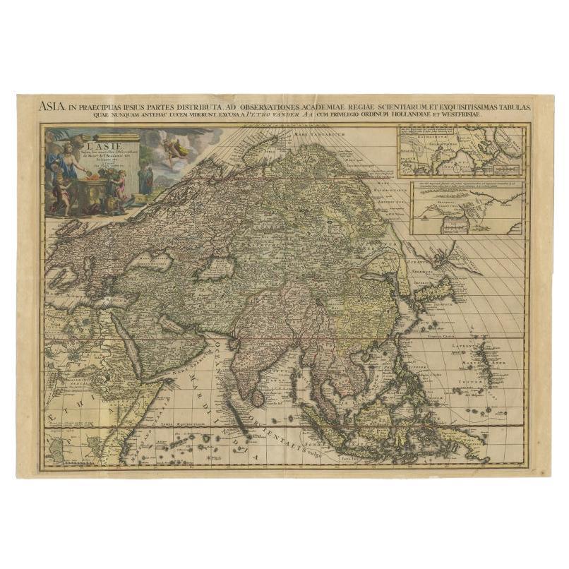
Important and Scarce Antique Map of Asia from Jesuit Sources, C.1713
Located in Langweer, NL
Antique map titled 'L'Asie selon les nouvelles observations de Messrs de l'Academie des Sciences etc'. The main focus of this important and scarce map of Asia is the delineation of the northeast part of the continent from Jesuit sources. The northeast coast is severely truncated with the discoveries of Nicolas Witsen shown, and the partial coastlines of Jesso and Compagnies Land are depicted to the north of Japan. Inset in the North Pacific is a map of that same region based on the information from Father Martino Martini. It shows Jesso connected to the mainland with a narrow strait between it and a huge Compagnies Land. An inset below, taken from Father Ferdinand Verbiest, illustrates the road between Peking and Kirin and Nincrita. Father Verbiest's world map of 1674, which he compiled for the Chinese, subsequently led to the Jesuits obtaining a commission to make a comprehensive topographical...
Category
Antique 18th Century Maps
Materials
Paper

$3,322 Sale Price
20% Off
You May Also Like
Antique 1803 Italian Map of Asia Including China Indoneseia India
Located in Amsterdam, Noord Holland
Antique 1803 Italian Map of Asia Including China Indoneseia India
Very nice map of Asia. 1803.
Additional information:
Type: Map
Country of Manufacturing: Europe
Period: 19th centu...
Category
Antique 19th Century European Maps
Materials
Paper

$438 Sale Price
39% Off
Antique French Map of Asia Including China Indoneseia India, 1783
Located in Amsterdam, Noord Holland
Very nice map of Asia. 1783 Dedie au Roy.
Additional information:
Country of Manufacturing: Europe
Period: 18th century Qing (1661 - 1912)
Condition: Overall Condition B (Good Used)...
Category
Antique 18th Century European Maps
Materials
Paper

$486 Sale Price
40% Off
Asia Declineatio: A 17th Century Hand-colored Map of Asia by Justus Danckerts
Located in Alamo, CA
This is a scarce 17th century beautifully hand-colored copperplate engraved map of Asia entitled “Exactissima Asiae Delineatio in Praecipuas Regiones Caerterasque Partes divisa et de...
Category
Late 17th Century Old Masters Landscape Prints
Materials
Engraving

Map of the East Indies: An Original 18th Century Hand-colored Map by E. Bowen
Located in Alamo, CA
This is an original 18th century hand-colored map entitled "An Accurate Map of the East Indies Exhibiting the Course of the European Trade both on the Continent and Islands" by Emanu...
Category
Mid-18th Century Old Masters Landscape Prints
Materials
Engraving

Accuratissima Totius Asiae Tabula - Etching by Frederick de Wit - 1680 ca
By Frederick de Wit
Located in Roma, IT
This double-page etching with contemporary coloring, entitled Accuratissima totius Asiae Tabula, was realized by the cartographer Frederick de Wit for the famous Atlas published in A...
Category
1680s Modern Figurative Prints
Materials
Etching

China: An Original 18th Century Hand-colored Map by E. Bowen
Located in Alamo, CA
This is an original 18th century hand-colored map entitled "A New & Accurate Map of China, Drawn from Surveys made by the Jesuit Missionaries, by order of the Emperor. The whole bein...
Category
Mid-18th Century Old Masters Landscape Prints
Materials
Engraving

More Ways To Browse
19th Century Round Dining Table
Carved Chinese Tables
Mid Century Modern Danish Teak Dining Tables
Long Rug Runners
Pair Arm Chairs
Sterling Silver Dinner Sets
United Chair Company
British Antiques
Italian Beech Chairs
Shirvan Rugs
Spain Marble
Vintage Brown Bottles
Vintage Danish Tables And Chairs
1960s Glass Top Coffee Table
Black Glass Coffee Tables
Burnt Wood
Mid Century Wrought Iron Chairs
Earth Toned Rug