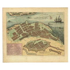
Items Similar to The City of Cowlang – Antique Map of Kollam (Quilon), India by Baldaeus, ca.1672

Video Loading
Want more images or videos?
Request additional images or videos from the seller
1 of 11
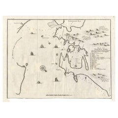
The City of Cowlang – Antique Map of Kollam (Quilon), India by Baldaeus, ca.1672
$760.79
£566.26
€640
CA$1,055.15
A$1,135.96
CHF 608.33
MX$13,687.91
NOK 7,675.42
SEK 7,024.25
DKK 4,877.98
About the Item
The City of Cowlang – Antique Map of Kollam (Quilon), India by Philip Baldaeus, c.1672
Rare and beautifully hand-colored 17th-century bird’s-eye plan of the fortified coastal city of Cowlang (modern Kollam or Quilon) on the Malabar Coast of India. The engraving shows the city’s defensive walls, bastions, streets, churches, convents, and key administrative buildings, as well as the harbor with European sailing ships anchored offshore.
The map originates from A True and Exact Description of the Most Celebrated East India Coasts of Malabar and Coromandel and the Isle of Ceylon (English edition of Naauwkeurige Beschryvinge van Malabar en Choromandel… en het machtige Eyland Ceylon) by Philippus Baldaeus, published in London around 1672. This important work records the geography, commerce, and missionary efforts of the Dutch East India Company (VOC) in southern India and Sri Lanka during the 17th century.
Cowlang (Kollam) was one of the earliest centers of European trade on the Malabar Coast, known for its spice markets and pearl fisheries. The plan’s key (A–G) identifies important landmarks: the port, the Dutch fort and governor’s residence, public buildings, churches, convents, and private houses. The detail of fortifications and European-style structures reflects the influence of the Dutch East India Company after their expulsion of the Portuguese from the region in 1658.
Philip Baldaeus (1632–1672), a Dutch Reformed minister and missionary, was among the first Europeans to study and document Tamil and Sinhalese culture in depth. His accounts and illustrations are among the most vivid early European descriptions of South India and Ceylon.
A rare and historically significant view combining early colonial cartography, architecture, and ethnography—an important visual record of VOC presence on the southwest coast of India.
Condition: Excellent impression with later hand-coloring on laid paper. Light toning and faint vertical fold as issued. Wide margins.
Framing tips: Best presented in a dark wood or teak frame with a cream or sand-colored mat to complement the warm coastal tones and maritime details.
Technique: Hand-colored copperplate engraving on laid paper
Maker: Philippus Baldaeus (author), anonymous engraver, Amsterdam or London, c.1672
- Dimensions:Height: 13.59 in (34.5 cm)Width: 16.54 in (42 cm)Depth: 0.01 in (0.2 mm)
- Materials and Techniques:Paper,Engraved
- Place of Origin:
- Period:1670-1679
- Date of Manufacture:circa 1672
- Condition:Condition: Excellent impression with later hand-coloring on laid paper. Light toning and faint vertical fold as issued. Wide margins.
- Seller Location:Langweer, NL
- Reference Number:Seller: PCT-587391stDibs: LU3054347116942
About the Seller
5.0
Recognized Seller
These prestigious sellers are industry leaders and represent the highest echelon for item quality and design.
Platinum Seller
Premium sellers with a 4.7+ rating and 24-hour response times
Established in 2009
1stDibs seller since 2017
2,828 sales on 1stDibs
Typical response time: 1 hour
- ShippingRetrieving quote...Shipping from: Langweer, Netherlands
- Return Policy
More From This Seller
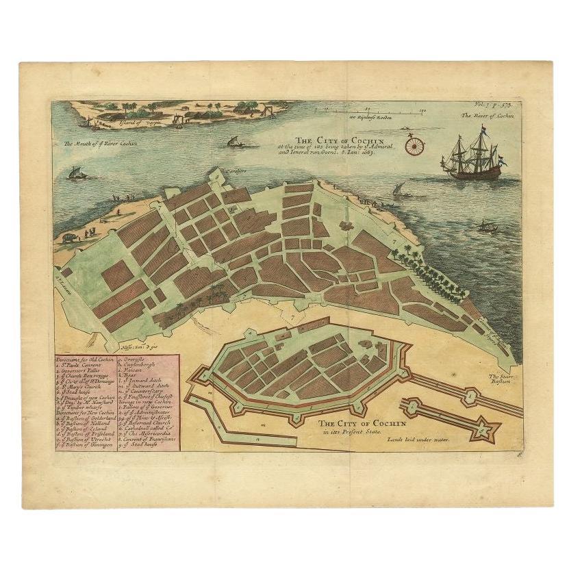
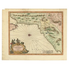
View AllVery Attractive Handcolored Antique Plan of Cochin in India, 1744
By Philip Baldaeus
Located in Langweer, NL
Antique map titled 'The City of Cochin (..).' Plan of Cochin, Malabar Coast, India, during the attack by Admiral van Goens in 1663. This map was published in 'The True and Exact Desc...
Category
Antique 18th Century Maps
Materials
Paper
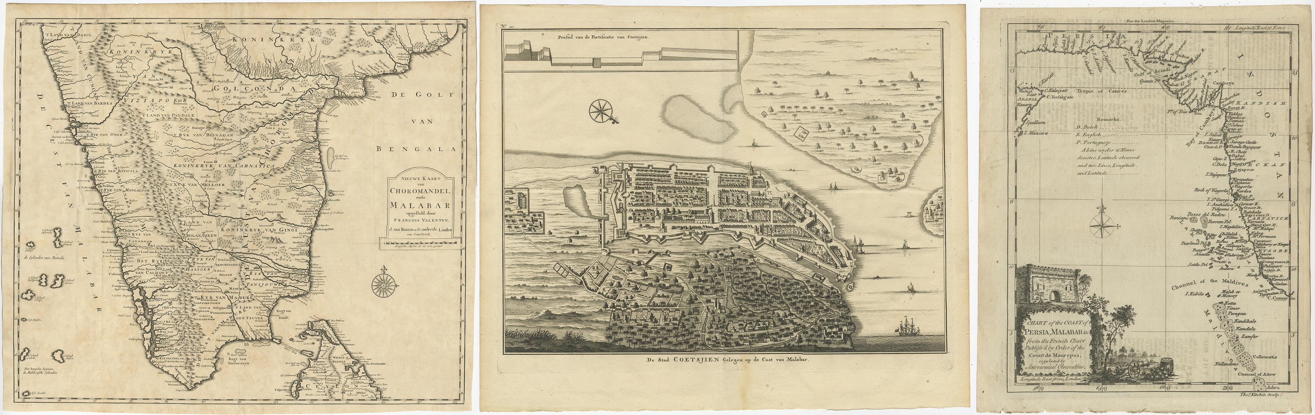
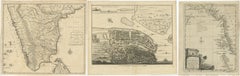
Antique Maps of the Malabar Coast – Valentyn, Cochin, and Malabar, 17
Located in Langweer, NL
Antique Maps of the Malabar Coast – Valentyn, Cochin, and London Magazine, 17th–18th Century
Description:
This compilation of three antique maps and views offers a remarkable cross-...
Category
Antique 19th Century Maps
Materials
Paper
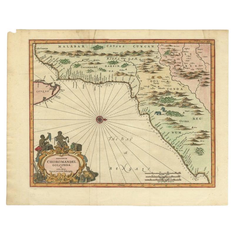
Antique Map of Choromandel, Golconda and Orixa, Malabar, India, 1744
By Philip Baldaeus
Located in Langweer, NL
Antique map titled 'Regionum Choromandel, Golconda (..).' Handsome map of Choromandel, Golconda and Orixa, published in 'The True and Exact Description of the Most Celebrated East - ...
Category
Antique 18th Century Maps
Materials
Paper
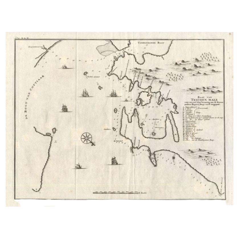
Antique Map of Trincomalee and Tambalagam Bay, 1758
Located in Langweer, NL
Antique map titled 'Bay de Trinquemale'. Map of Trincomalee and Tambalagam Bay in Sri Lanka. While these maps by Van Schley after Bellin were initially made for 'Histoire Generale de...
Category
Antique 18th Century Maps
Materials
Paper
$171 Sale Price
20% Off
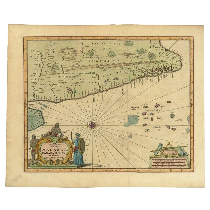
Antique Map of the Malabar Coast by Baldaeus, 1744
By Philip Baldaeus
Located in Langweer, NL
Antique map titled 'Descriptio Nova Imperii Malabar (..).' Nice map of the Malabar Coast. This map was published in 'The True and Exact Description of th...
Category
Antique 18th Century Maps
Materials
Paper
Antique Map of the City of Batavia by Van der Aa, circa 1730
Located in Langweer, NL
Antique map titled 'Plan de la Ville et du Chateau de Batavia en l'Isle de Iava - Ware affbeeldinge wegens het Casteel ende Stadt Batavia gelegen op groot Eylant Java'. Detailed plan...
Category
Antique Mid-18th Century Dutch Maps
Materials
Paper

You May Also Like
Antique Map - Gallia - Etching by Johannes Janssonius - 1650s
By Johannes Janssonius
Located in Roma, IT
Antique Map - Gallia is an antique map realized in 1650 by Johannes Janssonius (1588-1664).
The Map is Hand-colored etching, with coeval watercoloring.
Good conditions with slight ...
Category
1650s Modern Figurative Prints
Materials
Etching

Ancient Map - Zeilan - Etching by Johannes Janssonius - 1650s
By Johannes Janssonius
Located in Roma, IT
Ancient Map - Zeilan is an ancient map realized in 1650 by Johannes Janssonius (1588-1664).
The Map is Hand-colored etching, with coeval watercoloring.
...
Category
1650s Modern Figurative Prints
Materials
Etching

1646 Jansson Map Entitled "Procinvia Connactiae, " Ric.a006
Located in Norton, MA
1646 Jansson map entitled
"Procinvia connactiae,"
Ric.a006
Description: The PROVINCE of CONNAVGT 490 x 380From vol 4 of Jansson's Atlas Novus 1646, published in Amsterdam with...
Category
Antique 17th Century Unknown Maps
Materials
Paper

18th Century Map Engraving - Plan of the Works of the City of Messina, Sicily
Located in Corsham, GB
A map of Messina, a harbour city in northeast Sicily. Inscribed with the title in plate to the lower edge, 'Plan of the Works of the City of Messina, one of the strongest and most co...
Category
18th Century More Prints
Materials
Engraving

$285 Sale Price
20% Off
Antique Map - Mare Pacificum - Etching by Johannes Janssonius - 1650s
By Johannes Janssonius
Located in Roma, IT
Mare Pacificum is an antique map realized in 1650 by Johannes Janssonius (1588-1664).
The Map is Hand-colored etching, with coeval watercolorang.
Good conditions with slight foxing...
Category
1650s Modern Figurative Prints
Materials
Etching

Antique Map - Mar Di Athiopia - Etching by Johannes Janssonius - 1650s
By Johannes Janssonius
Located in Roma, IT
Antique Map - Mar Di Athiopia is an antique map realized in 1650 by Johannes Janssonius (1588-1664).
The Map is Hand-colored etching, with coeval watercolorang.
Good conditions wit...
Category
1650s Modern Figurative Prints
Materials
Etching
