Items Similar to Crete Map 1749 – Homann Heirs Engraving of Candia with Aegean Islands


Video Loading
Want more images or videos?
Request additional images or videos from the seller
1 of 11
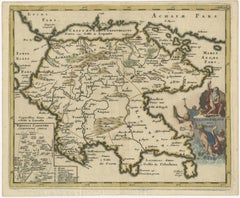
Crete Map 1749 – Homann Heirs Engraving of Candia with Aegean Islands
$1,281.72
£956.08
€1,080
CA$1,783.96
A$1,913.87
CHF 1,026.56
MX$23,042.79
NOK 12,941.03
SEK 11,800.43
DKK 8,230.42
About the Item
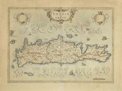
Crete Map 1749 – Homann Heirs Engraving of Candia with Aegean Islands
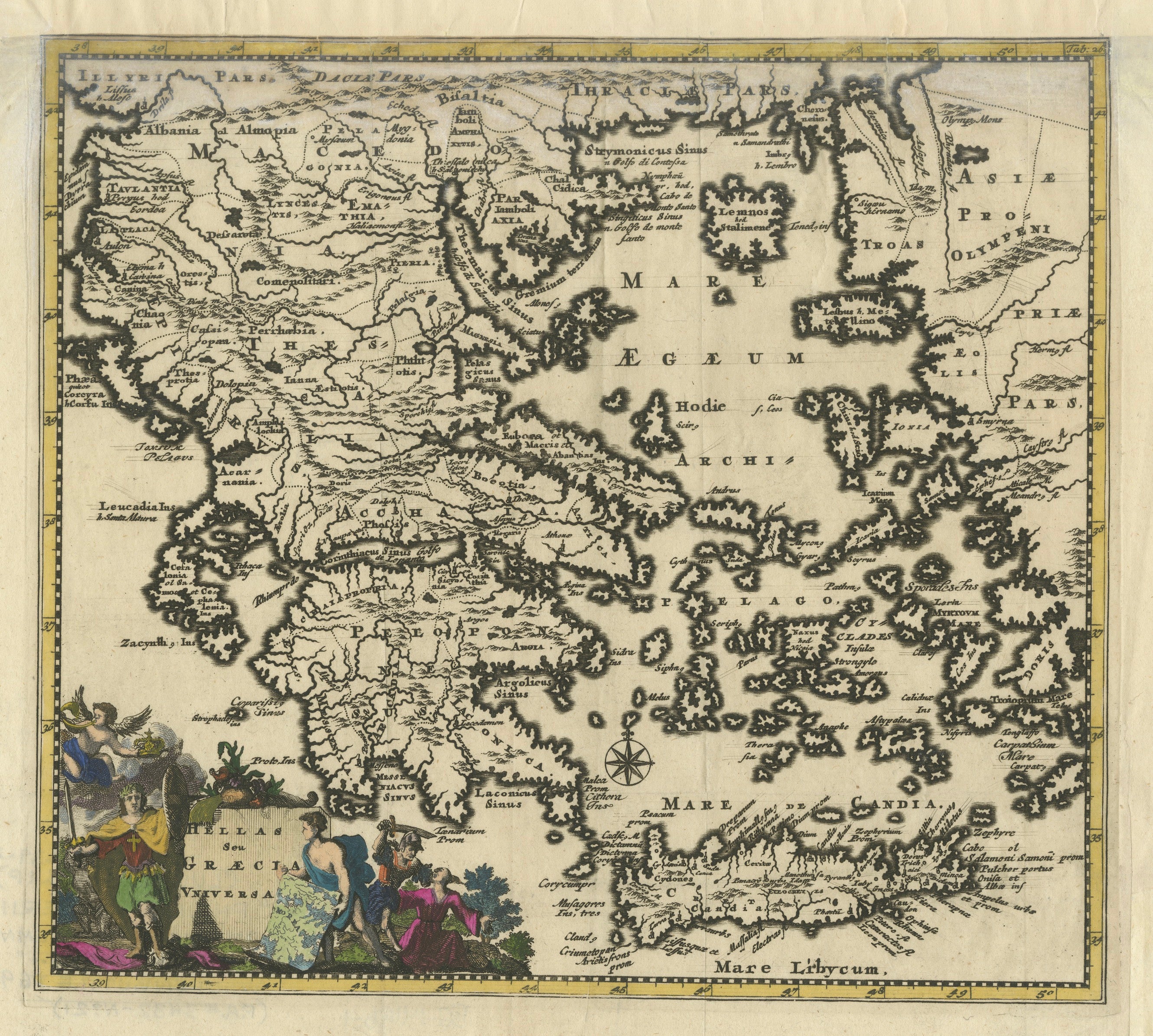
This fine 1749 map titled 'Insula Creta hodie Candia' presents an 18th-century cartographic portrait of the island of Crete, then known as Candia, published by the esteemed Homann Heirs in Nuremberg. Based on the original work by Johann Baptist Homann, this copperplate engraving exemplifies the clarity, precision, and decorative flourish for which the Homann publishing house was renowned. The sheet measures approximately 56 x 48 cm and is delicately hand-colored in the traditional manner, with subtle outlining of provincial borders in soft pastel tones. The large baroque title cartouche in the upper left remains uncolored, offering a dramatic contrast to the detailed geography.
This map provides an impressively detailed depiction of the island’s topography, settlements, and coastline, featuring mountains, fortified towns, and regional divisions. Above Crete, the southern Aegean is richly populated with the Cyclades and other surrounding Greek islands, each carefully labeled and positioned to reflect both strategic significance and navigational interest. The elegant balance between artistic embellishment and geographic functionality is characteristic of Homann maps of the period.
Johann Baptist Homann (1663–1724) established his reputation as the leading German mapmaker of his time. After his death, the firm continued under the imprint "Homann Heirs" and maintained its prominence through the 18th century. This map is a testament to the firm’s enduring legacy, combining informative cartography with refined aesthetic sensibility.
Condition:
The map is in very good condition, with original hand color and strong impression. There is a vertical centerfold, as issued, with mild toning around the edges and a few small spots that do not affect the visual appeal. The large decorative cartouche remains uncolored, as originally intended, adding depth and graphic interest to the composition.
Framing Tips:
This map will display beautifully in a natural or gilded wood frame, ideally with a double mount to echo the coloring of the sea and island terrain. A subtle olive or parchment-colored mat can enhance the classical feel. It would be well-suited for a library, study, or a coastal interior, offering both historical richness and elegant charm.
- Dimensions:Height: 20.56 in (52.2 cm)Width: 23.86 in (60.6 cm)Depth: 0.01 in (0.2 mm)
- Materials and Techniques:Paper,Engraved
- Place of Origin:
- Period:
- Date of Manufacture:1749
- Condition:The map is in very good condition, with original hand color and strong impression. There is a vertical centerfold, as issued, with mild toning around the edges and a few small spots that do not affect the visual appeal.
- Seller Location:Langweer, NL
- Reference Number:Seller: BG-140281stDibs: LU3054345436722
About the Seller
5.0
Recognized Seller
These prestigious sellers are industry leaders and represent the highest echelon for item quality and design.
Platinum Seller
Premium sellers with a 4.7+ rating and 24-hour response times
Established in 2009
1stDibs seller since 2017
2,830 sales on 1stDibs
Typical response time: 1 hour
- ShippingRetrieving quote...Shipping from: Langweer, Netherlands
- Return Policy
More From This Seller
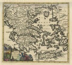
View AllAntique Map of the Peloponnese – Peloponnesus, Morea, by Cluver, ca.1697
Located in Langweer, NL
Hellas seu Graecia Universa is a finely detailed late-17th-century map of Greece and the Aegean world, issued by Philipp Cluver around 1697 (possibly 1694). The map was published in ...
Category
Antique Late 17th Century German Maps
Materials
Paper
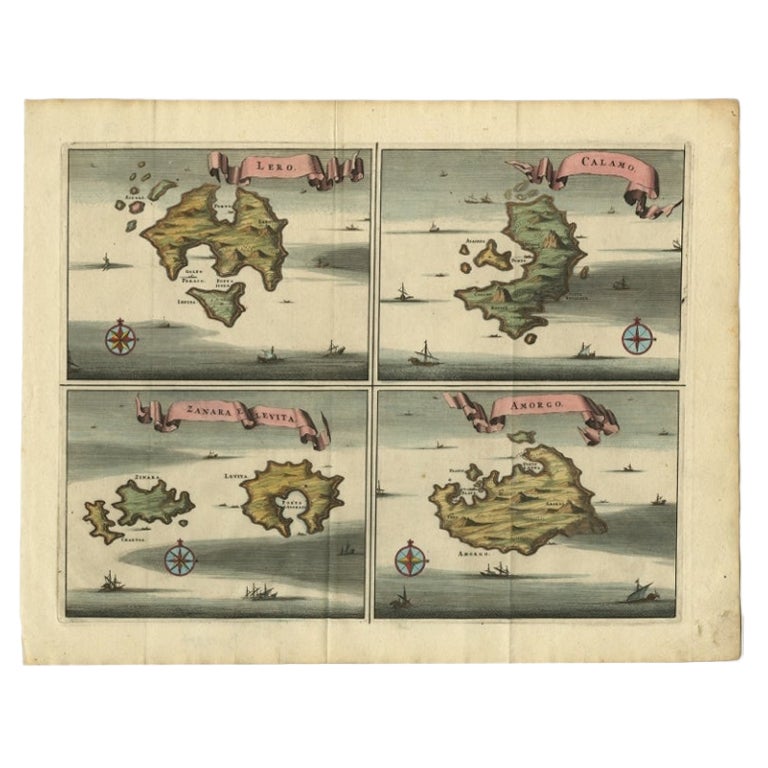
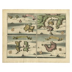
Original Antique Map of Leros and Kalimnos, and other islands, Greece, 1687
Located in Langweer, NL
Antique map titled 'Lero, Calamo, Zanara e Levita, Amorgo.'
heet with four maps on one page showing the islands Leros, Kalimnos, and other islands, Greece. Source unknown, to be de...
Category
Antique 17th Century Maps
Materials
Paper

Antique Classical Greece Map – Aegean Sea
Crete, ca.1697
Located in Langweer, NL
Hellas seu Graecia Universa is a finely detailed late-17th-century map of Greece and the Aegean world, issued by Philipp Cluver around 1697 (possibly 1694). The map was published in ...
Category
Antique Late 17th Century Maps
Materials
Paper
Antique Map of Menorca / Minorca by Homann Heirs
1757
Located in Langweer, NL
Antique map titled 'Carte Topographique de l'Isle Minorque'. Scarce decorative map of Menorca (or Minorca), with two gorgeous views of Mahon and Fort St. Phillipe at the bottom. Publ...
Category
Antique Mid-18th Century Maps
Materials
Paper

$759 Sale Price
20% Off
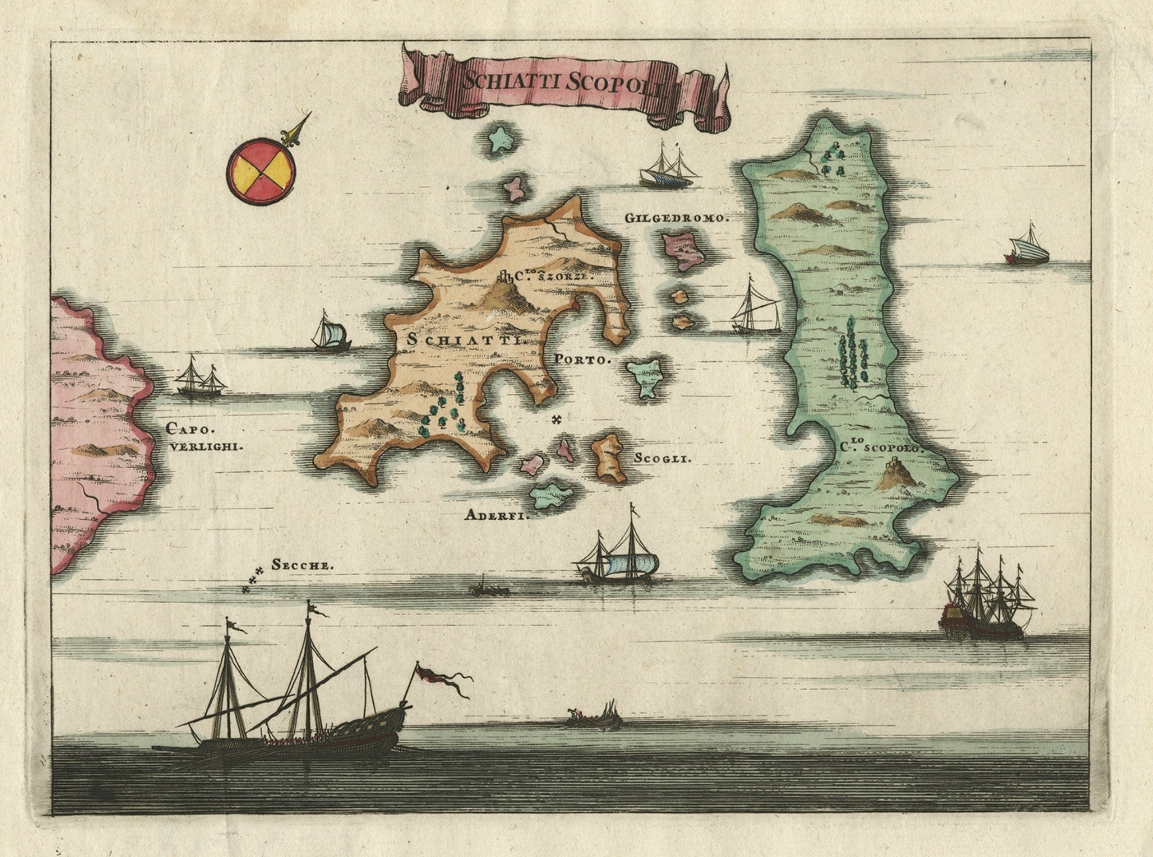
Antique Map of the Islands of Schiatti and Scopoli, Greece, 1687
Located in Langweer, NL
Antique map titled 'Schiatti - Scopoli.' This original antique map shows the islands Schiatti and Scopoli in Greece. Source unknown, to be determined.
Artists and Engravers: Made by...
Category
Antique 17th Century Maps
Materials
Paper
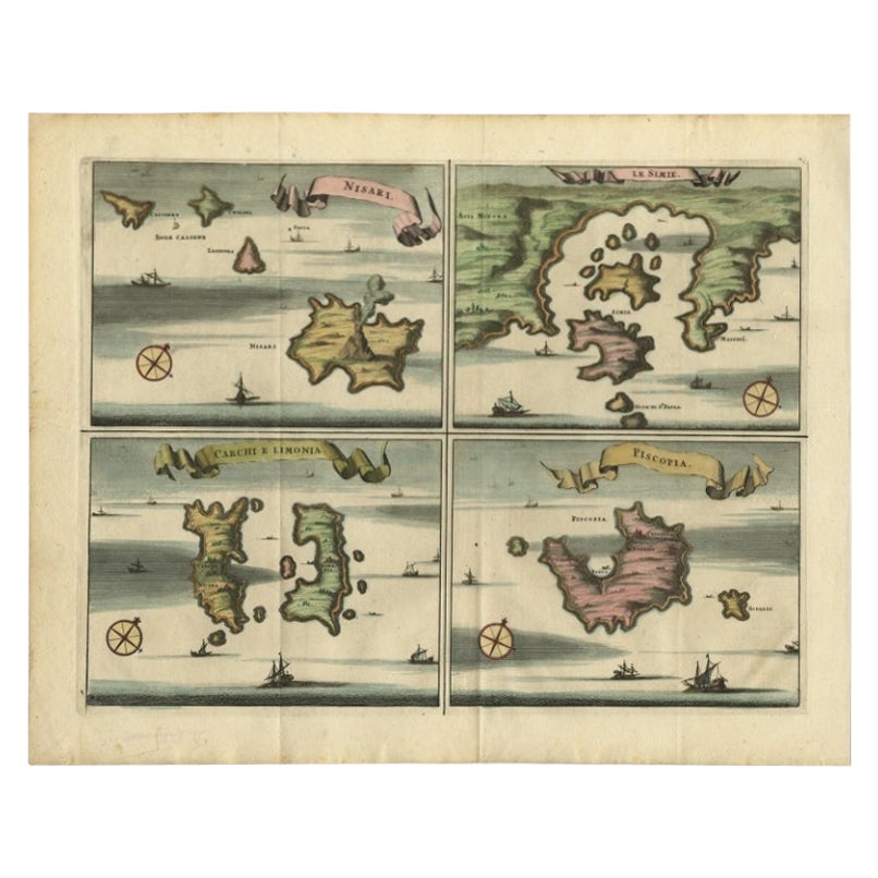
Antique Map of Nisari, Le Simie, Carchi Elimoia and Piscopia, Greece, 1687
Located in Langweer, NL
Antique map titled 'Carchi Elimoia, Nisari, Le Simie, Piscopia.' Sheet with four maps on one page showing Nisyros, Simi and other islands, Greece. Source unknown, to be determined. A...
Category
Antique 17th Century Maps
Materials
Paper
You May Also Like
Map of Crete - Etching by Johannes Blaeu - 1650s
Located in Roma, IT
Map of Crete (Candia olim Creta) is an etching realized by Johannes BLAEU (1596-1673) in 1650s.
Etching hand watercolored.
The renowned map of the island of Crete by Blaeu, hand-...
Category
1650s Modern Figurative Prints
Materials
Etching
Antique Map - Map of Greece - Etching by Johannes Janssonius - 1650s
By Johannes Janssonius
Located in Roma, IT
Antique Map of Greece - Graecia Vniversa is an antique map realized in 1650 by Johannes Janssonius (1588-1664).
The Map is Hand-colored etching, with coeval watercoloring.
Good co...
Category
1650s Modern Figurative Prints
Materials
Etching

Map of Greece - Etching by Antonio Zatta - 18th Century
Located in Roma, IT
This Map of Greece is an etching realized by Antonio Zatta, Cartographer, publisher and typographer.
The state of preservation of the artwork is good except for the worn paper and t...
Category
1780s Figurative Prints
Materials
Etching

Antique Map - Mar Di Athiopia - Etching by Johannes Janssonius - 1650s
By Johannes Janssonius
Located in Roma, IT
Antique Map - Mar Di Athiopia is an antique map realized in 1650 by Johannes Janssonius (1588-1664).
The Map is Hand-colored etching, with coeval watercolorang.
Good conditions wit...
Category
1650s Modern Figurative Prints
Materials
Etching

Antique Map - Archipela Meridionalis - Etching by Johannes Janssonius - 1650s
By Johannes Janssonius
Located in Roma, IT
Antique Map - Archipela Meridionalis is an antique map realized in 1650 by Johannes Janssonius (1588-1664).
The Map is Hand-colored etching, with coeval watercolorang.
Good conditi...
Category
1650s Modern Figurative Prints
Materials
Etching

Antique Map - Gallia - Etching by Johannes Janssonius - 1650s
By Johannes Janssonius
Located in Roma, IT
Antique Map - Gallia is an antique map realized in 1650 by Johannes Janssonius (1588-1664).
The Map is Hand-colored etching, with coeval watercoloring.
Good conditions with slight ...
Category
1650s Modern Figurative Prints
Materials
Etching

More Ways To Browse
German Engraving
Antique Crete
Paisley Rugs and Carpets
Black And Chrome Lounge Chair
Vintage 1930 Dining Room Set
Antique Victorian Dining Tables
Environment Furniture
Italian Plastic Chairs
Made In Belgium
Black Crystal Glasses
French Mid Century Modern Rug
China Silk Rug
Chrome Glass Coffee Tables
Antique Italian Chairs
Antique Walnut Bar
Beni Ourain Rugs
French Iron And Glass Table
Glass Top Wood Base Coffee Tables